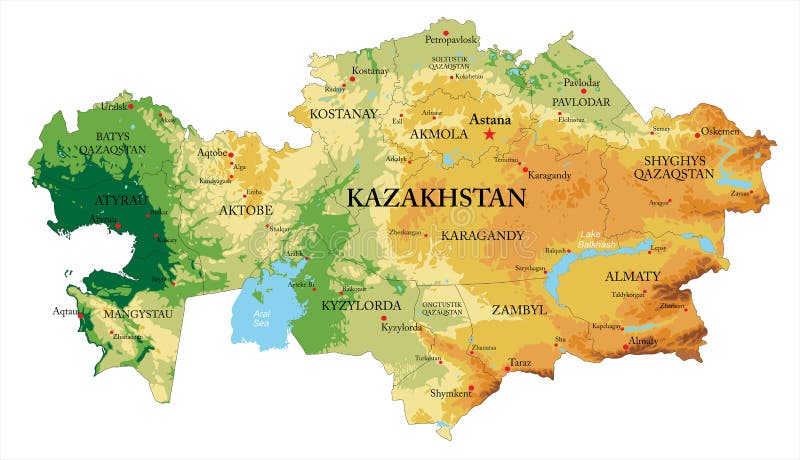
Free with trial Highly detailed physical map of Kazakhstan, in vector format, with all the relief forms and big cities. Alma ata vectors Kazakhstan relief map. Highly detailed physical map of Kazakhstan, in vector format, with all the relief forms and big cities
Free with trial Experience the captivating beauty of Alma Ata, Kazakhstan, from a unique perspective. This stunning aerial photograph showcases the vibrant urban sprawl of the city, seamlessly interwoven with the imposing mountain range that cradles it. The intricate network of roads, buildings, and parks unfolds before the viewer, revealing the city dynamic urban development. The juxtaposition of the city. Alma ata illustrations Breathtaking Aerial Panorama of Alma Ata Kazakhstan A City Nestled Amidst Majestic Mountains. Experience the captivating beauty of Alma Ata, Kazakhstan, from a unique perspective. This stunning aerial photograph showcases the vibrant urban sprawl of the city, seamlessly interwoven with the imposing mountain range that cradles it. The intricate network of roads, buildings, and parks unfolds before the viewer, revealing the city dynamic urban development. The juxtaposition of the city
Free with trial Location Map of Almaty Int. Airport (Alma-ata, Almaty, Kazakhstan). IATA-code: ALA. No labels at all. Alma ata illustrations Location Map of Almaty Int. Airport (Almaty, Kazakhstan). IATA-code ALA. Location Map of Almaty Int. Airport (Alma-ata, Almaty, Kazakhstan). IATA-code: ALA. No. Location Map of Almaty Int. Airport (Alma-ata, Almaty, Kazakhstan). IATA-code: ALA. No labels at all.
Free with trial Alma-Ata city map Kazakhstan - town streets on the plan. Monochrome line map of the scheme of road. Urban environment, architectural background. Vector. Alma ata vectors Alma-Ata city map Kazakhstan - town streets on the plan. Monochrome line map of the scheme of road. Vector. Alma-Ata city map Kazakhstan - town streets on the plan. Monochrome line map of the scheme of road. Urban environment, architectural background. Vector
Free with trial A map of a very beautiful city. Kazakhstan, the city of Alma-Ata. Alma ata illustrations Map of the city of Alma-Ata. A map of a very beautiful city. Kazakhstan, the city of Alma-Ata.
Free with trial Kazakhstan silhouette skyline. Kazakhstan - Alma-ata, Astana vector city, kazakh linear architecture, line travel illustration, landmarks. Kazakhstan flat icon, kazakh outline design, banner. Alma ata vectors Kazakhstan silhouette skyline. Kazakhstan - Alma-ata, Astana vector city, kazakh linear architecture, line travel
Free with trial Kazakhstan silhouette skyline. Kazakhstan - Alma-ata, Astana vector city, kazakh linear architecture, line travel illustration, landmarks. Kazakhstan flat icon, kazakh outline design banner. Alma ata illustrations Astana`s architectural landmarks , vector sketch illustration, Alma-ata, Astana. Kazakhstan silhouette skyline. Kazakhstan - Alma-ata, Astana vector city, kazakh linear architecture, line travel illustration, landmarks. Kazakhstan flat icon, kazakh outline design banner
Free with trial Kazakhstan, Alma-ata, Astana winter holidays skyline. Merry Christmas, Happy New Year decorated banner with Santa Claus. Outline vector. Kazakhstan, Alma-ata, Astana linear christmas city illustration. Alma ata vectors Kazakhstan, Alma-ata, Astana winter holidays skyline. Merry Christmas, Happy New Year decorated banner with Santa Claus
Free with trial Almaty city Republic of Kazakhstan, Regions of Kazakhstan map vector illustration, scribble sketch Alma-Ata and Verniy map,. Alma ata vectors Almaty city Republic of Kazakhstan, Regions of Kazakhstan map vector illustration, scribble sketch Alma-Ata and Verniy map
Free with trial Almaty city Republic of Kazakhstan, Regions of Kazakhstan map vector illustration, scribble sketch Alma-Ata and Verniy map,. Alma ata vectors Almaty city Republic of Kazakhstan, Regions of Kazakhstan map vector illustration, scribble sketch Alma-Ata and Verniy map
Free with trial Almaty city Republic of Kazakhstan, Regions of Kazakhstan map vector illustration, scribble sketch Alma-Ata and Verniy map,. Alma ata vectors Almaty city Republic of Kazakhstan, Regions of Kazakhstan map vector illustration, scribble sketch Alma-Ata and Verniy map
Free with trial Flag of Almaty formerly known as Alma-Ata and Verny is the largest city in Kazakhstan. 3D illustration. Alma ata illustrations Flag of Almaty, Kazakhstan. Flag of Almaty formerly known as Alma-Ata and Verny is the largest city in Kazakhstan. 3D illustration
Free with trial Flag of Almaty formerly known as Alma-Ata and Verny is the largest city in Kazakhstan. Alma ata illustrations Flag of Almaty, Kazakhstan. Flag of Almaty formerly known as Alma-Ata and Verny is the largest city in Kazakhstan
Free with trial Flag oSoviet Union 1980-1991 officially the Union of Soviet Socialist Republics USSR, was a transcontinental country that spanned much of Eurasia from 1922 to 1991. A flagship communist state, it was nominally a federal union comprising fifteen top-level republics; in practice, both its government and its economy were built on an authoritarian and highly centralized model until its final years. A Marxist Leninist one-party state, it was governed by the Communist Party of the Soviet Union, with Moscow as the capital. Other major cities included Leningrad, Kiev, Minsk, Tashkent, Alma Ata and Novosibirsk. It was by far the largest country in the world by land area, covering over 22,402,200 square kilometres 8,649,500 square miles and spanning eleven time zones. Alma ata illustrations Glossy glass Flag of Soviet Union 1980-1991. Flag oSoviet Union 1980-1991 officially the Union of Soviet Socialist Republics USSR, was a transcontinental country that spanned much of Eurasia from 1922 to 1991. A flagship communist state, it was nominally a federal union comprising fifteen top-level republics; in practice, both its government and its economy were built on an authoritarian and highly centralized model until its final years. A Marxist Leninist one-party state, it was governed by the Communist Party of the Soviet Union, with Moscow as the capital. Other major cities included Leningrad, Kiev, Minsk, Tashkent, Alma Ata and Novosibirsk. It was by far the largest country in the world by land area, covering over 22,402,200 square kilometres 8,649,500 square miles and spanning eleven time zones.
Free with trial Flag of Soviet Union 1923 1955 officially the Union of Soviet Socialist Republics USSR, was a transcontinental country that spanned much of Eurasia from 1922 to 1991. A flagship communist state, it was nominally a federal union comprising fifteen top-level republics; in practice, both its government and its economy were built on an authoritarian and highly centralized model until its final years. A Marxist Leninist one-party state, it was governed by the Communist Party of the Soviet Union, with Moscow as the capital. Other major cities included Leningrad, Kiev, Minsk, Tashkent, Alma Ata and Novosibirsk. It was by far the largest country in the world by land area, covering over 22,402,200 square kilometres 8,649,500 square miles and spanning eleven time zones. Alma ata illustrations Glossy glass Flag of Soviet Union 1923-1955. Flag of Soviet Union 1923 1955 officially the Union of Soviet Socialist Republics USSR, was a transcontinental country that spanned much of Eurasia from 1922 to 1991. A flagship communist state, it was nominally a federal union comprising fifteen top-level republics; in practice, both its government and its economy were built on an authoritarian and highly centralized model until its final years. A Marxist Leninist one-party state, it was governed by the Communist Party of the Soviet Union, with Moscow as the capital. Other major cities included Leningrad, Kiev, Minsk, Tashkent, Alma Ata and Novosibirsk. It was by far the largest country in the world by land area, covering over 22,402,200 square kilometres 8,649,500 square miles and spanning eleven time zones.
Free with trial Abstract city map. Town streets on the plan. Monochrome line map of the scheme of road. Urban environment, architectural background. Vector. Alma ata vectors Vector urban background. City map, with town streets on the plan. Scheme of road. Abstract city map. Town streets on the plan. Monochrome line map of the scheme of road. Urban environment, architectural background. Vector
Free with trial Coat of arms of the city of Almaty, Kazakhstan. Isolated on white background. Alma ata illustrations Coat of arms of the city of Almaty, Kazakhstan
Free with trial Almaty - region of Kazakhstan zoomed and highlighted with capital. Main physical landscape features. 3D rendering. Alma ata illustrations Almaty, Kazakhstan - highlighted with capital. Physical. Almaty - region of Kazakhstan zoomed and highlighted with capital. Main physical landscape features. 3D rendering
Free with trial Almaty - region of Kazakhstan zoomed and highlighted with capital. Satellite imagery. 3D rendering. Alma ata illustrations Almaty, Kazakhstan - highlighted with capital. Satellite. Almaty - region of Kazakhstan zoomed and highlighted with capital. Satellite imagery. 3D rendering
Free with trial Coat of arms of the city of Kapshagay. Kazakhstan. Isolated on white. Alma ata illustrations Coat of arms of the city of Kapshagay. Kazakhstan.
Free with trial Almaty - region of Kazakhstan zoomed and highlighted with capital. Colored and bumped map of the administrative division. 3D rendering. Alma ata illustrations Almaty, Kazakhstan - highlighted with capital. Administrative. Almaty - region of Kazakhstan zoomed and highlighted with capital. Colored and bumped map of the administrative division. 3D rendering
Free with trial Almaty Coat of Arms, Kazakhstan. 3D Illustration. Alma ata illustrations Almaty Coat of Arms, Kazakhstan.
Free with trial Map of Kazakhstan, Filled with the National Flag. Alma ata vectors Map of Kazakhstan, Filled with the National Flag
Free with trial Flag of the city of Almaty, Kazakhstan. Isolated on white background. Alma ata illustrations Flag of the city of Almaty, Kazakhstan
Free with trial 3D Flag of Almaty, Kazakhstan. 3D Illustration. Alma ata illustrations 3D Flag of Almaty, Kazakhstan.
Free with trial 3D Flag of Almaty, Kazakhstan. Close Up. Alma ata illustrations Flag of Almaty, Kazakhstan.
Free with trial Flag of Astana previously known as Akmolinsk, Tselinograd, Akmola and most recently Nur Sultan is the capital city of Kazakhstan. Alma ata illustrations Glossy glass Flag of Astana. Flag of Astana previously known as Akmolinsk, Tselinograd, Akmola and most recently Nur Sultan is the capital city of Kazakhstan.
Free with trial Flag of Kazakhstan official colors and proportions, vector image. Alma ata illustrations Flag of Kazakhstan official colors and proportions, vector image.
Free with trial Patriot heart in national Kazakhstan flag colors. Festive element, attributes of Kazakhstan Independence Day. Cartoon vector icon in national colors of country flag isolated on white background. Alma ata vectors Kazakhstan Flag Festive Patriot Heart Outline Icon. Patriot heart in national Kazakhstan flag colors. Festive element, attributes of Kazakhstan Independence Day. Cartoon vector icon in national colors of country flag isolated on white background
Free with trial Isolate flag of Kazakhstan on a flagpole fluttering in the wind on a blue background, 3d rendering. Alma ata illustrations Isolate flag of Kazakhstan on a flagpole fluttering in the wind on a blue background, 3d rendering
Free with trial Isolate flag of Kazakhstan on a flagpole fluttering in the wind on a white background, 3d rendering. Alma ata illustrations Isolate flag of Kazakhstan on a flagpole fluttering in the wind on a white background, 3d rendering.