Free with trial Danish straits and southern Baltic Sea, gray political map. Belts and sounds in Denmark, international waterways, connecting the Baltic Sea through Kattegat and Skagerrak to the North Sea. Vector. Belarus poland map vectors Danish straits and southern Baltic Sea, gray political map. Belts and sounds in Denmark, international waterways, connecting the Baltic Sea through Kattegat
Free with trial Bilevel globe map centered on Ukraine. Belarus poland map illustrations Globe centered on Ukraine. Bilevel map. Bilevel globe map centered on Ukraine
Free with trial Bilevel map centered on Lithuania neighborhood area. Belarus poland map illustrations Globe centered on Lithuania neighborhood. Bilevel map. Bilevel map centered on Lithuania neighborhood area
Free with trial Detailed white vector map of Europe with country borders on green background, info graphic, education, travel design, Europe, map, vector, geography, continent, outline, countries, green. Belarus poland map illustrations Detailed Europe Map on Green Background with Shadows. Detailed white vector map of Europe with country borders on green background, info graphic, education, travel design, Europe, map, vector, geography, continent, outline, countries, green
Free with trial Map of the Polish Podlaskie Voivodeship. Belarus poland map vectors Map of the Polish Podlaskie Voivodeship
Free with trial Prussian antique map in german language. Historical northern europe cartography. Belarus poland map illustrations Prussian antique map in german language. Soil types cartography. Prussian antique map in german language. Historical northern europe cartography
Free with trial Prussian antique map in german language. Vineyards, sugarcane mills. Spring temperature. Belarus poland map illustrations Prussian map in german language. Vineyards, sugarcane mills. Spring temperature
Free with trial Prussian antique map in german language. Historical northern europe cartography. Belarus poland map illustrations Prussian antique map in german language. Historical northern europe topography
Free with trial The Baltic States or the Baltic countries, political map. Geopolitical term encompassing Estonia, Latvia, and Lithuania, sometimes simply called the Baltics, all three members of the European Union. Belarus poland map vectors The Baltic States or the Baltic countries, political map of the Baltics. The Baltic States or the Baltic countries, political map. Geopolitical term encompassing Estonia, Latvia, and Lithuania, sometimes simply called the Baltics, all three members of the European Union.
Free with trial A stylized, simplified map of Europe featuring countries outlined in black and filled with vibrant, distinct colors. The map includes major landmasses and islands, presented against a clean white background. This graphic is ideal for educational materials, travel presentations, or conceptual designs related to European geography, culture, or politics. Belarus poland map illustrations Colorful Europe Map with Outline. A stylized, simplified map of Europe featuring countries outlined in black and filled with vibrant, distinct colors. The map includes major landmasses and islands, presented against a clean white background. This graphic is ideal for educational materials, travel presentations, or conceptual designs related to European geography, culture, or politics.
Free with trial A stylized, colorful map of Europe featuring distinct countries outlined and filled with various solid colors. The map includes major geographical regions and countries, presented on a clean white background. This graphic is ideal for educational purposes, travel planning, geopolitical discussions, or as a visual element in presentations and reports related to Europe. Belarus poland map illustrations Colorful Europe Map with Country Borders. A stylized, colorful map of Europe featuring distinct countries outlined and filled with various solid colors. The map includes major geographical regions and countries, presented on a clean white background. This graphic is ideal for educational purposes, travel planning, geopolitical discussions, or as a visual element in presentations and reports related to Europe.
Free with trial Vintage Map Of Ukraine With Oblasts On Retro Paper Background. Belarus poland map illustrations Vintage Map Of Ukraine With Oblasts On Retro Paper
Free with trial A 3D rendered illustration of the European continent, presented in a clean, minimalist style. The map features a light color palette, highlighting the geographical shapes and borders of the countries. This image is ideal for educational purposes, presentations, or as a background for various design projects related to Europe. Belarus poland map illustrations Europe Map - 3D Rendered Illustration. A 3D rendered illustration of the European continent, presented in a clean, minimalist style. The map features a light color palette, highlighting the geographical shapes and borders of the countries. This image is ideal for educational purposes, presentations, or as a background for various design projects related to Europe.
Free with trial Vintage Map Of Lithuania With Counties On Retro Paper Background. Belarus poland map illustrations Vintage Map Of Lithuania With Counties On Retro Paper
Free with trial A vibrant, stylized map of Europe showcasing country borders delineated by distinct colors: blue, green, orange, and yellow. The map features a clean white background, highlighting the geographical shapes of European nations. This graphic is ideal for presentations, educational materials, or any project requiring a clear and visually appealing representation of the European continent and its political divisions. Belarus poland map illustrations Colorful Map of Europe with Country Borders. A vibrant, stylized map of Europe showcasing country borders delineated by distinct colors: blue, green, orange, and yellow. The map features a clean white background, highlighting the geographical shapes of European nations. This graphic is ideal for presentations, educational materials, or any project requiring a clear and visually appealing representation of the European continent and its political divisions.
Free with trial This satellite-style map prominently features Germany highlighted in bright orange against a backdrop of Earth's continents and oceans. The image showcases Germany's geographical position within Europe, surrounded by surrounding countries and bodies of water. It's an ideal visual for presentations, educational materials, or any content related to Germany's location, European geography, or international relations. Belarus poland map illustrations Germany Highlighted on World Map - Geographic Location. This satellite-style map prominently features Germany highlighted in bright orange against a backdrop of Earth's continents and oceans. The image showcases Germany's geographical position within Europe, surrounded by surrounding countries and bodies of water. It's an ideal visual for presentations, educational materials, or any content related to Germany's location, European geography, or international relations.
Free with trial This is a clean, stylized map graphic showcasing the country of Lithuania prominently highlighted in green against a white background. The map displays the outline of Europe with surrounding countries and bodies of water rendered in thin black lines. The focus is on Lithuania's geographical location and borders within the broader European context. This image is ideal for educational materials, travel guides, geopolitical discussions, and presentations related to Lithuania and its neighboring regions. Belarus poland map illustrations Map of Lithuania Highlighted Green on European Continent Outline. This is a clean, stylized map graphic showcasing the country of Lithuania prominently highlighted in green against a white background. The map displays the outline of Europe with surrounding countries and bodies of water rendered in thin black lines. The focus is on Lithuania's geographical location and borders within the broader European context. This image is ideal for educational materials, travel guides, geopolitical discussions, and presentations related to Lithuania and its neighboring regions.
Free with trial A map of Europe highlighting country borders, major bodies of water, and key geographical features. Belarus poland map illustrations Detailed map of europe showing country borders and major bodies of water. A map of Europe highlighting country borders, major bodies of water, and key geographical features
Free with trial Ukraine political map showing the capital Kyiv, major cities, and national borders, ideal for geographic. Belarus poland map illustrations Ukraine Political Map with capital Kyiv, most important cities and national borders. Ukraine political map showing the capital Kyiv, major cities, and national borders, ideal for geographic
Free with trial Lithuania political map featuring the capital Vilnius, major cities, and national borders, ideal for educational, geographic, and reference purposes. Belarus poland map illustrations Lithuania political map with capital Vilnius, most important cities and national borders. Lithuania political map featuring the capital Vilnius, major cities, and national borders, ideal for educational, geographic, and reference purposes
Free with trial Close-up of arelief map centered on Russia. Belarus poland map illustrations Russia area. Relief map. Close-up of arelief map centered on Russia
Free with trial Close-up of abilevel map centered on Russia. Belarus poland map illustrations Russia area. Bilevel map. Close-up of abilevel map centered on Russia
Free with trial Close-up of abilevel map centered on Ukraine. Belarus poland map illustrations Ukraine area. Bilevel map. Close-up of abilevel map centered on Ukraine
Free with trial Close-up of aphysical map centered on Russia. Belarus poland map illustrations Russia area. Physical map. Close-up of aphysical map centered on Russia
Free with trial Close-up of agrayscale map centered on Russia. Belarus poland map illustrations Russia area. Grayscale map. Close-up of agrayscale map centered on Russia
Free with trial Close-up of agrayscale map centered on Ukraine. Belarus poland map illustrations Ukraine area. Grayscale map. Close-up of agrayscale map centered on Ukraine
Free with trial Close-up of abilevel map centered on Lithuania. Belarus poland map illustrations Lithuania area. Bilevel map. Close-up of abilevel map centered on Lithuania
Free with trial Close-up of aphysical map centered on Lithuania. Belarus poland map illustrations Lithuania area. Physical map. Close-up of aphysical map centered on Lithuania
Free with trial Close-up of atopographic map centered on Russia. Belarus poland map illustrations Russia area. Topographic map. Close-up of atopographic map centered on Russia
Free with trial Close-up of agrayscale map centered on Lithuania. Belarus poland map illustrations Lithuania area. Grayscale map. Close-up of agrayscale map centered on Lithuania
Free with trial Close-up of atopographic map centered on Ukraine. Belarus poland map illustrations Ukraine area. Topographic map. Close-up of atopographic map centered on Ukraine
Free with trial Close-up of aadministrative map centered on Russia. Belarus poland map illustrations Russia area. Administrative map. Close-up of aadministrative map centered on Russia
Free with trial Close-up of asepia elevation map centered on Russia. Belarus poland map illustrations Russia area. Sepia elevation map. Close-up of asepia elevation map centered on Russia
Free with trial Close-up of aadministrative map centered on Ukraine. Belarus poland map illustrations Ukraine area. Administrative map. Close-up of aadministrative map centered on Ukraine
Free with trial Close-up of asepia elevation map centered on Ukraine. Belarus poland map illustrations Ukraine area. Sepia elevation map. Close-up of asepia elevation map centered on Ukraine
Free with trial Close-up of asepia elevation map centered on Lithuania. Belarus poland map illustrations Lithuania area. Sepia elevation map. Close-up of asepia elevation map centered on Lithuania
Free with trial Detailed editable vector map of European Union, EU on Arab language. The map highlights countries boundaries, major cities, highways, rivers, and geographic features. Belarus poland map vectors Detailed editable vector map of Europa on Arab language. Detailed editable vector map of European Union, EU on Arab language. The map highlights countries boundaries, major cities, highways, rivers, and geographic features.
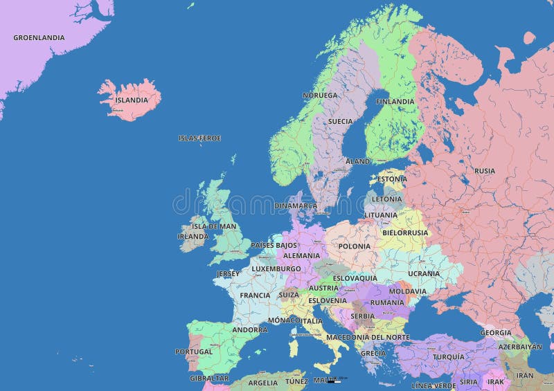
Free with trial Detailed editable vector map of European Union, EU on Polish language. The map highlights countries boundaries, major cities, highways, rivers, and geographic features. Belarus poland map vectors Detailed editable vector map of Europa on Polish language. Detailed editable vector map of European Union, EU on Polish language. The map highlights countries boundaries, major cities, highways, rivers, and geographic features.
Free with trial Detailed editable vector map of European Union, EU on French language. The map highlights countries boundaries, major cities, highways, rivers, and geographic features. Belarus poland map vectors Detailed editable vector map of Europa on French language. Detailed editable vector map of European Union, EU on French language. The map highlights countries boundaries, major cities, highways, rivers, and geographic features.
Free with trial Detailed editable vector map of European Union, EU on Hindi language. The map highlights countries boundaries, major cities, highways, rivers, and geographic features. Belarus poland map vectors Detailed editable vector map of Europa on Hindi language. Detailed editable vector map of European Union, EU on Hindi language. The map highlights countries boundaries, major cities, highways, rivers, and geographic features.
Free with trial Relief map centered on Russia neighborhood area. Belarus poland map illustrations Globe centered on Russia neighborhood. Relief map. Relief map centered on Russia neighborhood area
Free with trial Detailed editable vector map of European Union, EU on English language. The map highlights countries boundaries, major cities, highways, rivers, and geographic features. Belarus poland map vectors Detailed editable vector map of Europa on English language. Detailed editable vector map of European Union, EU on English language. The map highlights countries boundaries, major cities, highways, rivers, and geographic features.
Free with trial Map of Eastern Europe. Includes Ukraine, Belarus, Moldova, Romania, Bulgaria, Hungary, Slovakia, Czechia, and Poland with regional divisions. Isolated on a white background. Highly detailed vector illustration. Belarus poland map illustrations Highly detailed blue illustration map of Eastern Europe. Map of Eastern Europe. Includes Ukraine, Belarus, Moldova, Romania, Bulgaria, Hungary, Slovakia, Czechia, and Poland with regional divisions. Isolated on a white background. Highly detailed vector illustration.
Free with trial Relief globe map centered on Ukraine. Belarus poland map illustrations Globe centered on Ukraine. Relief map. Relief globe map centered on Ukraine
Free with trial Relief map centered on Ukraine neighborhood area. Belarus poland map illustrations Globe centered on Ukraine neighborhood. Relief map. Relief map centered on Ukraine neighborhood area
Free with trial Bilevel map centered on Russia neighborhood area. Belarus poland map illustrations Globe centered on Russia neighborhood. Bilevel map. Bilevel map centered on Russia neighborhood area
Free with trial Detailed editable vector map of European Union, EU on Spanish language. The map highlights countries boundaries, major cities, highways, rivers, and geographic features. Belarus poland map vectors Detailed editable vector map of Europa on Spanish language. Detailed editable vector map of European Union, EU on Spanish language. The map highlights countries boundaries, major cities, highways, rivers, and geographic features.
Free with trial Detailed editable vector map of European Union, EU on Italian language. The map highlights countries boundaries, major cities, highways, rivers, and geographic features. Belarus poland map vectors Detailed editable vector map of Europa on Italian language. Detailed editable vector map of European Union, EU on Italian language. The map highlights countries boundaries, major cities, highways, rivers, and geographic features.
Free with trial Detailed editable vector map of European Union, EU on Chinese language. The map highlights countries boundaries, major cities, highways, rivers, and geographic features. Belarus poland map vectors Detailed editable vector map of Europa on Chinese language. Detailed editable vector map of European Union, EU on Chinese language. The map highlights countries boundaries, major cities, highways, rivers, and geographic features.
Free with trial Detailed editable vector map of European Union, EU on Russian language. The map highlights countries boundaries, major cities, highways, rivers, and geographic features. Belarus poland map vectors Detailed editable vector map of Europa on Russian language. Detailed editable vector map of European Union, EU on Russian language. The map highlights countries boundaries, major cities, highways, rivers, and geographic features.
Free with trial Bilevel map centered on Ukraine neighborhood area. Belarus poland map illustrations Globe centered on Ukraine neighborhood. Bilevel map. Bilevel map centered on Ukraine neighborhood area
Free with trial Physical map centered on Russia neighborhood area. Belarus poland map illustrations Globe centered on Russia neighborhood. Physical map. Physical map centered on Russia neighborhood area
Free with trial Grayscale map centered on Russia neighborhood area. Belarus poland map illustrations Globe centered on Russia neighborhood. Grayscale map. Grayscale map centered on Russia neighborhood area
Free with trial Relief globe map centered on Lithuania. Belarus poland map illustrations Globe centered on Lithuania. Relief map. Relief globe map centered on Lithuania
Free with trial Physical map centered on Ukraine neighborhood area. Belarus poland map illustrations Globe centered on Ukraine neighborhood. Physical map. Physical map centered on Ukraine neighborhood area
Free with trial Relief map illustrating European nations with focus on countries bordering Turkey in black and gray Great for geographic or political illustrations. Belarus poland map illustrations Europe Map Relief Showing Countries Bordering Turkey. Relief map illustrating European nations with focus on countries bordering Turkey in black and gray Great for geographic or political illustrations
Free with trial Bilevel globe map centered on Lithuania. Belarus poland map illustrations Globe centered on Lithuania. Bilevel map. Bilevel globe map centered on Lithuania
Free with trial Grayscale globe map centered on Ukraine. Belarus poland map illustrations Globe centered on Ukraine. Grayscale map. Grayscale globe map centered on Ukraine
Free with trial Grayscale map centered on Ukraine neighborhood area. Belarus poland map illustrations Globe centered on Ukraine neighborhood. Grayscale map. Grayscale map centered on Ukraine neighborhood area
Free with trial Topographic map centered on Russia neighborhood area. Belarus poland map illustrations Globe centered on Russia neighborhood. Topographic map. Topographic map centered on Russia neighborhood area
Free with trial Physical map centered on Lithuania neighborhood area. Belarus poland map illustrations Globe centered on Lithuania neighborhood. Physical map. Physical map centered on Lithuania neighborhood area
Free with trial Physical globe map centered on Lithuania. Belarus poland map illustrations Globe centered on Lithuania. Physical map. Physical globe map centered on Lithuania
Free with trial Topographic map centered on Ukraine neighborhood area. Belarus poland map illustrations Globe centered on Ukraine neighborhood. Topographic map. Topographic map centered on Ukraine neighborhood area
Free with trial Grayscale globe map centered on Lithuania. Belarus poland map illustrations Globe centered on Lithuania. Grayscale map. Grayscale globe map centered on Lithuania
Free with trial Topographic globe map centered on Ukraine. Belarus poland map illustrations Globe centered on Ukraine. Topographic map. Topographic globe map centered on Ukraine
Free with trial Grayscale map centered on Lithuania neighborhood area. Belarus poland map illustrations Globe centered on Lithuania neighborhood. Grayscale map. Grayscale map centered on Lithuania neighborhood area
Free with trial Administrative map centered on Russia neighborhood area. Belarus poland map illustrations Globe centered on Russia neighborhood. Administrative map. Administrative map centered on Russia neighborhood area
Free with trial Map of Belgium with administrative divisions and highlighted position on Europe map. Isolated on white background. Vector illustration. Belarus poland map vectors Belgium Map with Administrative Divisions and Europe Highlight. Map of Belgium with administrative divisions and highlighted position on Europe map. Isolated on white background. Vector illustration.
Free with trial Administrative globe map centered on Ukraine. Belarus poland map illustrations Globe centered on Ukraine. Administrative map. Administrative globe map centered on Ukraine
Free with trial Sepia elevation globe map centered on Ukraine. Belarus poland map illustrations Globe centered on Ukraine. Sepia elevation map. Sepia elevation globe map centered on Ukraine
Free with trial Sepia elevation map centered on Ukraine neighborhood area. Belarus poland map illustrations Globe centered on Ukraine neighborhood. Sepia elevation map. Sepia elevation map centered on Ukraine neighborhood area
Free with trial Sepia elevation globe map centered on Lithuania. Belarus poland map illustrations Globe centered on Lithuania. Sepia elevation map. Sepia elevation globe map centered on Lithuania
Free with trial This antique-style map depicts the European continent with unique lettering and a sepia tone. Belarus poland map illustrations Vintage map of Europe with stylized country names and borders. This antique-style map depicts the European continent with unique lettering and a sepia tone
Free with trial Detailed vector map of Ukraine featuring key cities such as Kiev, Lviv, Kharkiv, Odessa, and Dnepropetrovsk. Includes surrounding countries. Belarus poland map illustrations Ukraine Country Map with Major Cities, Borders, and European Context. Detailed vector map of Ukraine featuring key cities such as Kiev, Lviv, Kharkiv, Odessa, and Dnepropetrovsk. Includes surrounding countries
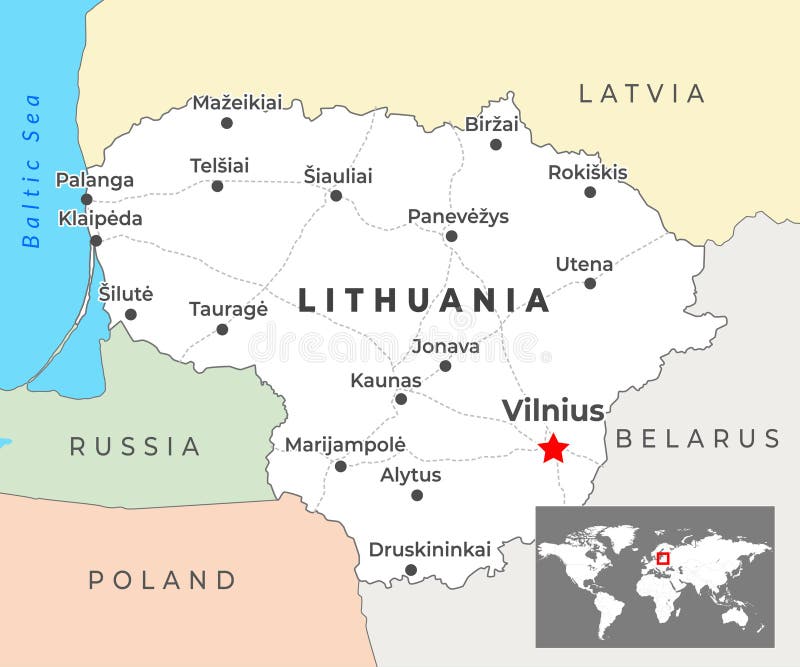
Free with trial Vector map of Lithuania showing cities like Vilnius, Kaunas, and Klaip? da with rivers and borders. Includes an inset map highlighting Lithuania's location within Europe. Belarus poland map illustrations Lithuania Country Map with Major Cities, Borders, and European Context. Vector map of Lithuania showing cities like Vilnius, Kaunas, and Klaip?da with rivers and borders. Includes an inset map highlighting Lithuania's location within Europe
Free with trial Close-up of asatellite map centered on Russia. Belarus poland map illustrations Russia area. Satellite map. Close-up of asatellite map centered on Russia
Free with trial Close-up of asatellite map centered on Russia. Belarus poland map illustrations Russia area. Satellite map. Close-up of asatellite map centered on Russia
Free with trial Close-up of asatellite map centered on Russia. Belarus poland map illustrations Russia area. Satellite map. Close-up of asatellite map centered on Russia