Free with trial 3D Germany white map with regions and main cities. Brandenburg area illustrations 3D Germany white map on grey. 3D Germany white map with regions and main cities
Free with trial Administrative and political vector map of Germany, newly revised 2019. Brandenburg area vectors Administrative and political vector map of Germany, newly revised 2019
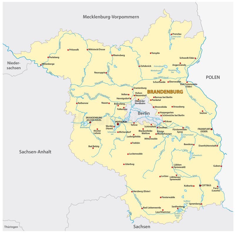
Free with trial Map of the state of Brandenburg in German language. Brandenburg area vectors Map of the state of Brandenburg in German languageBrandenburg, Germany, state, europe, central, map, brandenburg, germany, border. Map of the state of Brandenburg in German language.
Free with trial Map Administrative Structure Federal State Brandenburg Unified Municipality, Administrative Community, Administrative Association. Brandenburg area vectors Map Administrative Structure State of Brandenburg. Map Administrative Structure Federal State Brandenburg Unified Municipality, Administrative Community, Administrative Association
Free with trial Brandenburg state map, Germany, vector map silhouette illustration isolated on Germany map. Editable blank vector map. Province in Germany. Brandenburg area illustrations Brandenburg state map, Germany, vector map silhouette. Brandenburg state map, Germany, vector map silhouette illustration isolated on Germany map. Editable blank vector map. Province in Germany.
Free with trial Brandenburg red highlighted in map of Germany illustration. Brandenburg area illustrations Brandenburg red highlighted in map of Germany
Free with trial Map Administrative Structure Federal State Brandenburg counties and independent cities. Brandenburg area vectors Map Administrative Structure State of Brandenburg. Map Administrative Structure Federal State Brandenburg counties and independent cities
Free with trial Flag of German State Brandenburg waving on an isolated white background. Brandenburg area illustrations Flag of German state Brandenburg waving on an isolated white background.
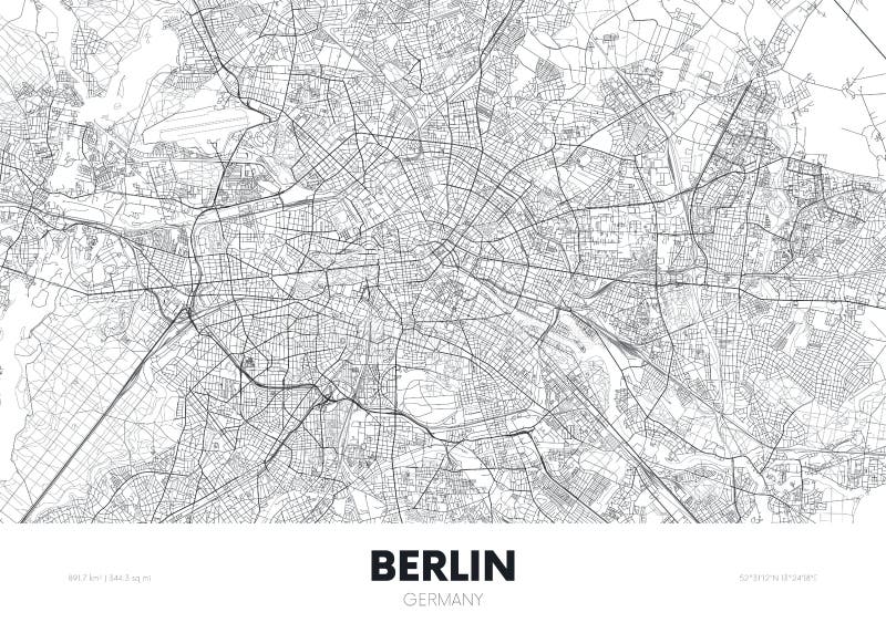
Free with trial Berlin Urban Area City Map. Black and White Vector Silhouette Version. Rich details for highways, roads and smaller streets. Usable for travel marketing, real estate and education. Brandenburg area vectors Berlin Urban Area City Map
Free with trial City map Berlin Germany, travel poster detailed urban street plan, vector illustration for design. Brandenburg area vectors City map Berlin Germany, travel poster detailed urban street plan, vector illustration
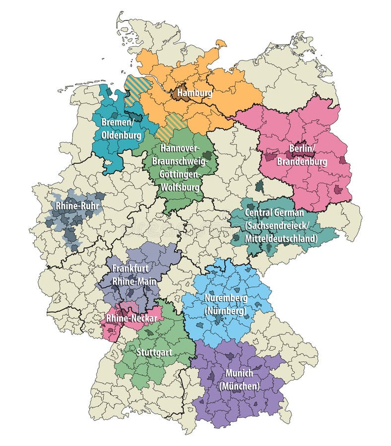
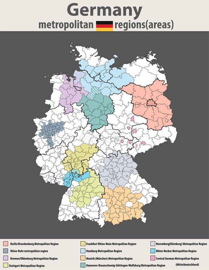
Free with trial Germany metropolitan regions vector isolated map. Brandenburg area vectors Germany metropolitan regions vector map. Germany metropolitan regions vector isolated map
Free with trial Saxony administrative and political map in german language. Brandenburg area vectors Saxony administrative and political map in german language
Free with trial Map of the state Saxony with the most important cities in german language. Brandenburg area vectors Map of the state Saxony with the most important cities in german language
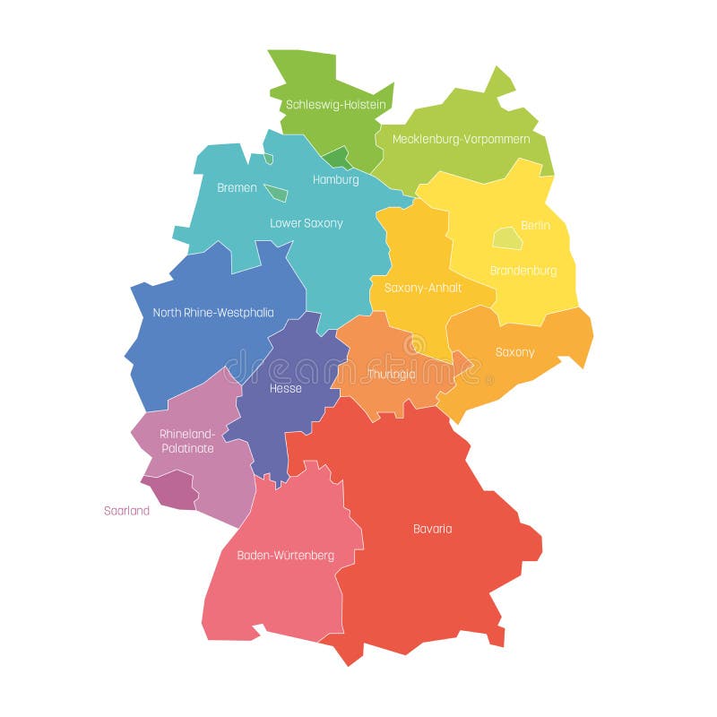
Free with trial States of Germany. Map of regional country administrative divisions. Colorful vector illustration. Brandenburg area vectors States of Germany. Map of regional country administrative divisions. Colorful vector illustration
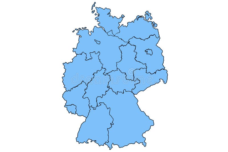
Free with trial Germany map and federal states map vector blue. Brandenburg area illustrations Germany map and federal states map vector blue
Free with trial Germany Map Administrative Structure Federal State Saxony-Anhalt counties and independent cities maps. Brandenburg area vectors Map Administrative Structure State of Saxony-Anhalt Germany. Germany Map Administrative Structure Federal State Saxony-Anhalt counties and independent cities maps
Free with trial Vector high detailed map of Germany metropolitan regions areas. Brandenburg area vectors Vector high detailed map of Germany metropolitan regions areas
Free with trial Vector high detailed map of Germany metropolitan regions areas. Brandenburg area vectors Vector high detailed map of Germany metropolitan regions areas
Free with trial Classic cars are on the road near the Brandenburg Gate in Germany. People walk on the sidewalk. The sun shines through clouds in the sky. This scene shows a bustling urban area. Brandenburg area illustrations Classic cars drive through the Brandenburg Gate in Germany during the mid-20th century. Classic cars are on the road near the Brandenburg Gate in Germany. People walk on the sidewalk. The sun shines through clouds in the sky. This scene shows a bustling urban area.
Free with trial Stunning night scene of Berlin with golden 2027 digits and fireworks illuminating the Brandenburg Gate area. Brandenburg area illustrations Festive 2027 New Year night in Berlin with fireworks over Brandenburg Gate and city skyline. Stunning night scene of Berlin with golden 2027 digits and fireworks. Stunning night scene of Berlin with golden 2027 digits and fireworks illuminating the Brandenburg Gate area
Free with trial This image is a detailed map of Berlin, Germany, showcasing the city's intricate network of roads and highways. The central area of Berlin is highlighted in green, providing a clear focus on the heart of the city. Major roads and highways are marked in yellow, connecting various districts and neighborhoods. Surrounding areas include notable locations such as Potsdam, Brandenburg, and other suburbs. Brandenburg area illustrations Detailed map of berlin with highlighted central area. This image is a detailed map of Berlin, Germany, showcasing the city's intricate network of roads and highways. The central area of Berlin is highlighted in green, providing a clear focus on the heart of the city. Major roads and highways are marked in yellow, connecting various districts and neighborhoods. Surrounding areas include notable locations such as Potsdam, Brandenburg, and other suburbs
Free with trial Symbol Map of the city Calau (Brandenburg, Germany) showing the area of the city with just a few black horizontal lines. Brandenburg area illustrations Map of the city Calau (Brandenburg, Germany)
Free with trial Symbol Map of the city Seelow (Brandenburg, Germany) showing the area of the city with just a few black horizontal lines. Brandenburg area illustrations Map of the city Seelow (Brandenburg, Germany)
Free with trial Symbol Map of the city Kyritz (Brandenburg, Germany) showing the area of the city with just a few black horizontal lines. Brandenburg area illustrations Map of the city Kyritz (Brandenburg, Germany)
Free with trial Symbol Map of the city Luckau (Brandenburg, Germany) showing the area of the city with just a few black horizontal lines. Brandenburg area illustrations Map of the city Luckau (Brandenburg, Germany)
Free with trial Symbol Map of the city Drebkau (Brandenburg, Germany) showing the area of the city with just a few black horizontal lines. Brandenburg area illustrations Map of the city Drebkau (Brandenburg, Germany)
Free with trial Symbol Map of the city Kremmen (Brandenburg, Germany) showing the area of the city with just a few black horizontal lines. Brandenburg area illustrations Map of the city Kremmen (Brandenburg, Germany)
Free with trial Symbol Map of the city Beeskow (Brandenburg, Germany) showing the area of the city with just a few black horizontal lines. Brandenburg area illustrations Map of the city Beeskow (Brandenburg, Germany)
Free with trial Symbol Map of the city Gransee (Brandenburg, Germany) showing the area of the city with just a few black horizontal lines. Brandenburg area illustrations Map of the city Gransee (Brandenburg, Germany)
Free with trial Symbol Map of the city Wriezen (Brandenburg, Germany) showing the area of the city with just a few black horizontal lines. Brandenburg area illustrations Map of the city Wriezen (Brandenburg, Germany)
Free with trial Symbol Map of the city Heidesee (Brandenburg, Germany) showing the area of the city with just a few black horizontal lines. Brandenburg area illustrations Map of the city Heidesee (Brandenburg, Germany)
Free with trial Symbol Map of the city Kolkwitz (Brandenburg, Germany) showing the area of the city with just a few black horizontal lines. Brandenburg area illustrations Map of the city Kolkwitz (Brandenburg, Germany)
Free with trial Symbol Map of the city Rehfelde (Brandenburg, Germany) showing the area of the city with just a few black horizontal lines. Brandenburg area illustrations Map of the city Rehfelde (Brandenburg, Germany)
Free with trial Symbol Map of the city Nuthetal (Brandenburg, Germany) showing the area of the city with just a few black horizontal lines. Brandenburg area illustrations Map of the city Nuthetal (Brandenburg, Germany)
Free with trial Symbol Map of the city Premnitz (Brandenburg, Germany) showing the area of the city with just a few black horizontal lines. Brandenburg area illustrations Map of the city Premnitz (Brandenburg, Germany)
Free with trial Symbol Map of the city Schipkau (Brandenburg, Germany) showing the area of the city with just a few black horizontal lines. Brandenburg area illustrations Map of the city Schipkau (Brandenburg, Germany)
Free with trial Symbol Map of the city Karstaedt (Brandenburg, Germany) showing the area of the city with just a few black horizontal lines. Brandenburg area illustrations Map of the city Karstaedt (Brandenburg, Germany)
Free with trial Symbol Map of the city Eichwalde (Brandenburg, Germany) showing the area of the city with just a few black horizontal lines. Brandenburg area illustrations Map of the city Eichwalde (Brandenburg, Germany)
Free with trial Symbol Map of the city Bestensee (Brandenburg, Germany) showing the area of the city with just a few black horizontal lines. Brandenburg area illustrations Map of the city Bestensee (Brandenburg, Germany)
Free with trial Symbol Map of the city Bad Saarow (Brandenburg, Germany) showing the area of the city with just a few black horizontal lines. Brandenburg area illustrations Map of the city Bad Saarow (Brandenburg, Germany)
Free with trial Symbol Map of the city Fehrbellin (Brandenburg, Germany) showing the area of the city with just a few black horizontal lines. Brandenburg area illustrations Map of the city Fehrbellin (Brandenburg, Germany)
Free with trial Symbol Map of the city Leegebruch (Brandenburg, Germany) showing the area of the city with just a few black horizontal lines. Brandenburg area illustrations Map of the city Leegebruch (Brandenburg, Germany)
Free with trial Symbol Map of the city Rheinsberg (Brandenburg, Germany) showing the area of the city with just a few black horizontal lines. Brandenburg area illustrations Map of the city Rheinsberg (Brandenburg, Germany)
Free with trial Symbol Map of the city Biesenthal (Brandenburg, Germany) showing the area of the city with just a few black horizontal lines. Brandenburg area illustrations Map of the city Biesenthal (Brandenburg, Germany)
Free with trial Symbol Map of the city Werneuchen (Brandenburg, Germany) showing the area of the city with just a few black horizontal lines. Brandenburg area illustrations Map of the city Werneuchen (Brandenburg, Germany)
Free with trial Symbol Map of the city Elsterwerda (Brandenburg, Germany) showing the area of the city with just a few black horizontal lines. Brandenburg area illustrations Map of the city Elsterwerda (Brandenburg, Germany)
Free with trial Symbol Map of the city Woltersdorf (Brandenburg, Germany) showing the area of the city with just a few black horizontal lines. Brandenburg area illustrations Map of the city Woltersdorf (Brandenburg, Germany)
Free with trial Symbol Map of the city Grossbeeren (Brandenburg, Germany) showing the area of the city with just a few black horizontal lines. Brandenburg area illustrations Map of the city Grossbeeren (Brandenburg, Germany)
Free with trial Symbol Map of the city Muencheberg (Brandenburg, Germany) showing the area of the city with just a few black horizontal lines. Brandenburg area illustrations Map of the city Muencheberg (Brandenburg, Germany)
Free with trial Symbol Map of the city Mittenwalde (Brandenburg, Germany) showing the area of the city with just a few black horizontal lines. Brandenburg area illustrations Map of the city Mittenwalde (Brandenburg, Germany)
Free with trial Symbol Map of the city Schulzendorf (Brandenburg, Germany) showing the area of the city with just a few black horizontal lines. Brandenburg area illustrations Map of the city Schulzendorf (Brandenburg, Germany)
Free with trial Symbol Map of the city Altlandsberg (Brandenburg, Germany) showing the area of the city with just a few black horizontal lines. Brandenburg area illustrations Map of the city Altlandsberg (Brandenburg, Germany)
Free with trial Symbol Map of the city Birkenwerder (Brandenburg, Germany) showing the area of the city with just a few black horizontal lines. Brandenburg area illustrations Map of the city Birkenwerder (Brandenburg, Germany)
Free with trial Symbol Map of the city Ketzin_Havel (Brandenburg, Germany) showing the area of the city with just a few black horizontal lines. Brandenburg area illustrations Map of the city Ketzin_Havel (Brandenburg, Germany)
Free with trial Symbol Map of the city Am Mellensee (Brandenburg, Germany) showing the area of the city with just a few black horizontal lines. Brandenburg area illustrations Map of the city Am Mellensee (Brandenburg, Germany)
Free with trial Symbol Map of the city Schwarzheide (Brandenburg, Germany) showing the area of the city with just a few black horizontal lines. Brandenburg area illustrations Map of the city Schwarzheide (Brandenburg, Germany)
Free with trial Symbol Map of the city Grossraeschen (Brandenburg, Germany) showing the area of the city with just a few black horizontal lines. Brandenburg area illustrations Map of the city Grossraeschen (Brandenburg, Germany)
Free with trial Symbol Map of the city Treuenbrietzen (Brandenburg, Germany) showing the area of the city with just a few black horizontal lines. Brandenburg area illustrations Map of the city Treuenbrietzen (Brandenburg, Germany)
Free with trial Symbol Map of the city Storkow (Mark) (Brandenburg, Germany) showing the area of the city with just a few black horizontal lines. Brandenburg area illustrations Map of the city Storkow (Mark) (Brandenburg, Germany)
Free with trial Symbol Map of the city Bad Liebenwerda (Brandenburg, Germany) showing the area of the city with just a few black horizontal lines. Brandenburg area illustrations Map of the city Bad Liebenwerda (Brandenburg, Germany)
Free with trial Symbol Map of the city Niedergoersdorf (Brandenburg, Germany) showing the area of the city with just a few black horizontal lines. Brandenburg area illustrations Map of the city Niedergoersdorf (Brandenburg, Germany)
Free with trial Symbol Map of the city Nuthe-Urstromtal (Brandenburg, Germany) showing the area of the city with just a few black horizontal lines. Brandenburg area illustrations Map of the city Nuthe-Urstromtal (Brandenburg, Germany)
Free with trial Symbol Map of the city Falkenberg_Elster (Brandenburg, Germany) showing the area of the city with just a few black horizontal lines. Brandenburg area illustrations Map of the city Falkenberg_Elster (Brandenburg, Germany)
Free with trial Symbol Map of the city Loewenberger Land (Brandenburg, Germany) showing the area of the city with just a few black horizontal lines. Brandenburg area illustrations Map of the city Loewenberger Land (Brandenburg, Germany)
Free with trial Symbol Map of the city Gruenheide (Mark) (Brandenburg, Germany) showing the area of the city with just a few black horizontal lines. Brandenburg area illustrations Map of the city Gruenheide (Mark) (Brandenburg, Germany)
Free with trial Symbol Map of the city Herzberg (Elster) (Brandenburg, Germany) showing the area of the city with just a few black horizontal lines. Brandenburg area illustrations Map of the city Herzberg (Elster) (Brandenburg, Germany)
Free with trial Symbol Map of the city Fuerstenberg_Havel (Brandenburg, Germany) showing the area of the city with just a few black horizontal lines. Brandenburg area illustrations Map of the city Fuerstenberg_Havel (Brandenburg, Germany)
Free with trial Symbol Map of the city Doberlug-Kirchhain (Brandenburg, Germany) showing the area of the city with just a few black horizontal lines. Brandenburg area illustrations Map of the city Doberlug-Kirchhain (Brandenburg, Germany)
Free with trial Symbol Map of the city Vetschau_Spreewald (Brandenburg, Germany) showing the area of the city with just a few black horizontal lines. Brandenburg area illustrations Map of the city Vetschau_Spreewald (Brandenburg, Germany)
Free with trial Symbol Map of the city Wusterhausen_Dosse (Brandenburg, Germany) showing the area of the city with just a few black horizontal lines. Brandenburg area illustrations Map of the city Wusterhausen_Dosse (Brandenburg, Germany)
Free with trial Symbol Map of the city Uebigau-Wahrenbrueck (Brandenburg, Germany) showing the area of the city with just a few black horizontal lines. Brandenburg area illustrations Map of the city Uebigau-Wahrenbrueck (Brandenburg, Germany)
Free with trial Symbol Map of the city Gross Kreutz (Havel) (Brandenburg, Germany) showing the area of the city with just a few black horizontal lines. Brandenburg area illustrations Map of the city Gross Kreutz (Havel) (Brandenburg, Germany)
Free with trial Symbol Map of the city Strausberg (Brandenburg, Germany) showing the area of the city with just a few black horizontal lines. Brandenburg area illustrations Map of the city Strausberg (Brandenburg, Germany)
Free with trial Symbol Map of the city Ludwigsfelde (Brandenburg, Germany) showing the area of the city with just a few black horizontal lines. Brandenburg area illustrations Map of the city Ludwigsfelde (Brandenburg, Germany)
Free with trial Symbol Map of the city Schwedt_Oder (Brandenburg, Germany) showing the area of the city with just a few black horizontal lines. Brandenburg area illustrations Map of the city Schwedt_Oder (Brandenburg, Germany)
Free with trial Symbol Map of the city Bernau bei Berlin (Brandenburg, Germany) showing the area of the city with just a few black horizontal lines. Brandenburg area illustrations Map of the city Bernau bei Berlin (Brandenburg, Germany)
Free with trial Symbol Map of the city Neuenhagen bei Berlin (Brandenburg, Germany) showing the area of the city with just a few black horizontal lines. Brandenburg area illustrations Map of the city Neuenhagen bei Berlin (Brandenburg, Germany)
Free with trial Brandenburg state (Germany) outline map set. Brandenburg area vectors Brandenburg outline map. Brandenburg state (Germany) outline map set
Free with trial Symbol Map of the city Brandenburg an der Havel (Brandenburg, Germany) showing the area of the city with just a few black horizontal lines. Brandenburg area illustrations Map of the city Brandenburg an der Havel (Brandenburg, Germany)
Free with trial Illustrated cityscape of Berlin showcasing the Brandenburg Gate, modern buildings, and the TV Tower. Includes green spaces and urban architecture, highlighting city landmarks and urban design. Brandenburg area illustrations Berlin Cityscape with Brandenburg Gate and TV Tower. Illustrated cityscape of Berlin showcasing the Brandenburg Gate, modern buildings, and the TV Tower. Includes green spaces and urban architecture, highlighting city landmarks and urban design