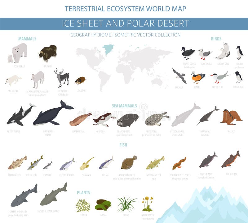
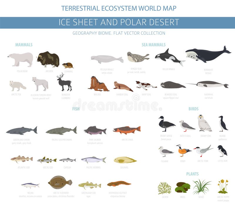
Free with trial Ice sheet and polar desert biome. Isometric 3d style. Terrestrial ecosystem world map. Arctic animals, birds, fish and plants infographic design. Vector illustration. Desert biome map vectors Ice sheet and polar desert biome. Isometric 3d style. Terrestrial ecosystem world map. Arctic animals, birds, fish and plants
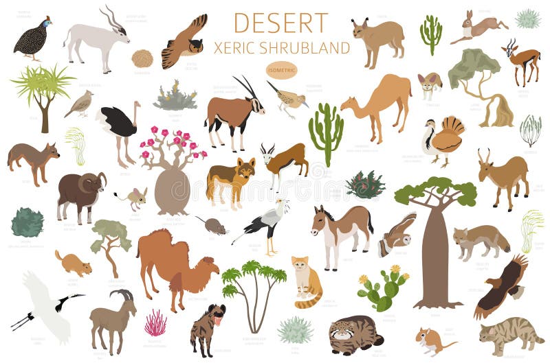
Free with trial Desert biome, xeric shrubland natural region infographic. Terrestrial ecosystem world map. Animals, birds and vegetations design set. Vector illustration. Desert biome map vectors Desert biome, xeric shrubland natural region infographic. Terrestrial ecosystem world map. Animals, birds and vegetations design
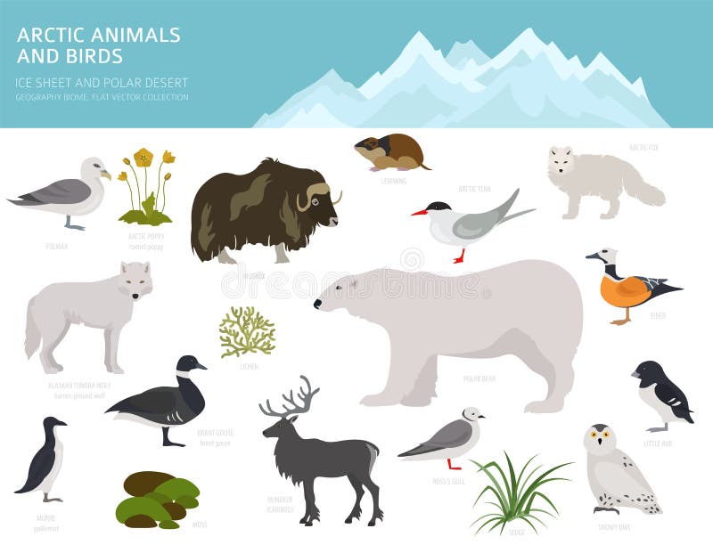
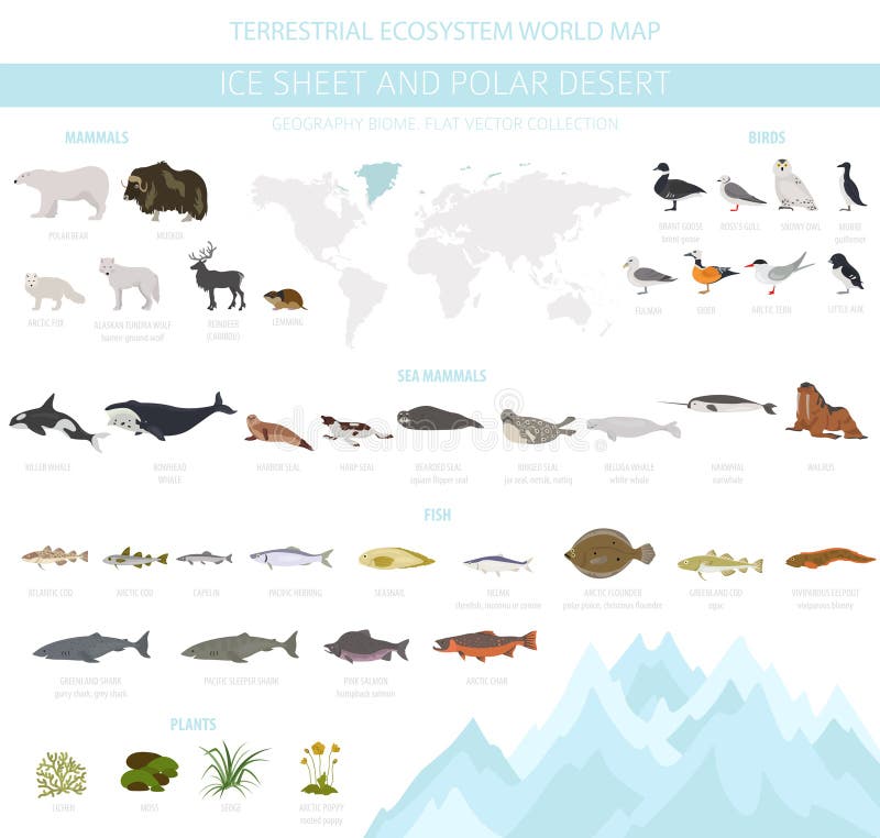
Free with trial Ice sheet and polar desert biome. Terrestrial ecosystem world map. Arctic animals, birds, fish and plants infographic design. Vector illustration. Desert biome map vectors Ice sheet and polar desert biome. Terrestrial ecosystem world map. Arctic animals, birds, fish and plants infographic design
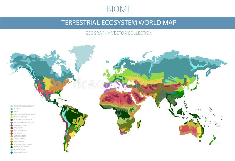
Free with trial Terrestrial ecosystem world map. Biome. World climatic zone infographic design. Vector illustration. Desert biome map vectors Terrestrial ecosystem world map. Biome. World climatic zone infographic design
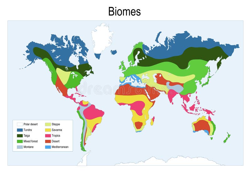
Free with trial Biomes. Terrestrial ecosystem is a community of living organisms. Biotope: montane, desert, tropics, savanna, steppe, mediterranean, mixed forest, taiga, tundra and polar desert. world map. Desert biome map vectors Biomes. world map. Biomes. Terrestrial ecosystem is a community of living organisms. Biotope: montane, desert, tropics, savanna, steppe, mediterranean, mixed forest, taiga, tundra and polar desert. world map
Free with trial Biomes. Terrestrial ecosystem is a community of living organisms. Biotope: montane, desert, tropics, savanna, steppe, mediterranean, mixed forest, taiga, tundra and polar desert. Vector map. Desert biome map vectors Biomes. Terrestrial ecosystem
Free with trial Biome pyramid as ecological weather or climate classification outline diagram. Educational labeled scheme with temperature and moisture axis that effects polar, subpolar, temperate and tropical region. Desert biome map vectors Biome pyramid as ecological weather or climate classification outline diagram
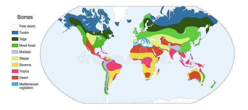
Free with trial Biomes. Color map of The main biomes in the world. Vector illustration. Desert biome map vectors Color map of The main biomes in the world
Free with trial Ice sheet and polar desert biome. Terrestrial ecosystem world map. Arctic animals, birds, fish and plants infographic design. Vector illustration. Desert biome map vectors Ice sheet and polar desert biome. Terrestrial ecosystem world map. Arctic animals, birds, fish and plants infographic design
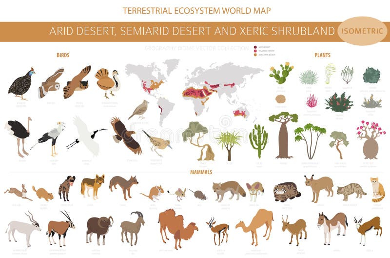
Free with trial Desert biome, xeric shrubland biome, natural region infographic. Terrestrial ecosystem world map. Animals, birds and vegetations isometric design set. Vector illustration. Desert biome map vectors Desert biome, xeric shrubland biome, natural region infographic. Terrestrial ecosystem world map. Animals, birds and vegetations
Free with trial Terrestrial ecosystem world map. Biome. World climatic zone infographic design. Vector illustration. Desert biome map vectors Terrestrial ecosystem world map. Biome. World climatic zone infographic design
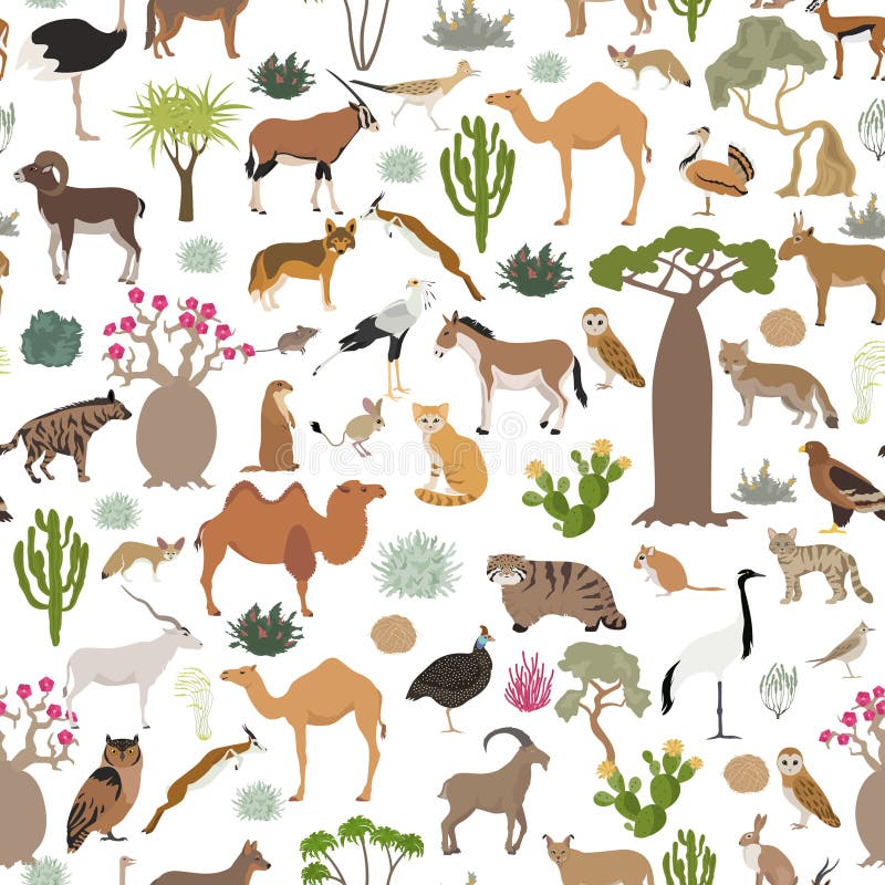
Free with trial Desert biome, xeric shrubland biome, natural region seamless pattern. Terrestrial ecosystem world map. Animals, birds and vegetations design set. Vector illustration. Desert biome map vectors Desert biome, xeric shrubland biome, natural region seamless pattern. Terrestrial ecosystem world map. Animals, birds and
Free with trial Ice sheet and polar desert biome. Terrestrial ecosystem world map. Arctic animals, birds, fish and plants infographic design. Vector illustration. Desert biome map vectors Ice sheet and polar desert biome. Terrestrial ecosystem world map. Arctic animals, birds, fish and plants infographic design
Free with trial Ice sheet and polar desert biome. Terrestrial ecosystem world map. Arctic animals, birds, fish and plants infographic design. Vector illustration. Desert biome map vectors Ice sheet and polar desert biome. Terrestrial ecosystem world map. Arctic animals, birds, fish and plants infographic design
Free with trial Ice sheet and polar desert biome. Isometric 3d style. Terrestrial ecosystem world map. Arctic animals, birds, fish and plants infographic design. Vector illustration. Desert biome map illustrations Ice sheet and polar desert biome. Isometric 3d style. Terrestrial ecosystem world map. Arctic animals, birds, fish and plants
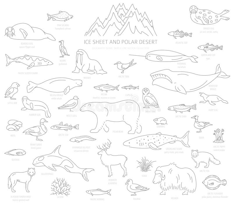
Free with trial Ice sheet and polar desert biome. Simple line style. Terrestrial ecosystem world map. Arctic animals, birds, fish and plants infographic design. Vector illustration. Desert biome map vectors Ice sheet and polar desert biome. Simple line style. Terrestrial ecosystem world map. Arctic animals, birds, fish and plants
Free with trial Ice sheet and polar desert biome. Terrestrial ecosystem world map. Arctic animals, birds, fish and plants infographic design. Vector illustration. Desert biome map vectors Ice sheet and polar desert biome. Terrestrial ecosystem world map. Arctic animals, birds, fish and plants infographic design
Free with trial Ice sheet and polar desert biome. Terrestrial ecosystem world map. Arctic animals, birds, fish and plants infographic design. Vector illustration. Desert biome map vectors Ice sheet and polar desert biome. Terrestrial ecosystem world map. Arctic animals, birds, fish and plants infographic design
Free with trial Ice sheet and polar desert biome. Simple line style. Terrestrial ecosystem world map. Arctic animals, birds, fish and plants infographic design. Vector illustration. Desert biome map vectors Ice sheet and polar desert biome. Simple line style. Terrestrial ecosystem world map. Arctic animals, birds, fish and plants
Free with trial Desert biome, xeric shrubland natural region infographic. Terrestrial ecosystem world map. Animals, birds and vegetations design set. Vector illustration. Desert biome map vectors Desert biome, xeric shrubland natural region infographic. Terrestrial ecosystem world map. Animals, birds and vegetations design
Free with trial Ice sheet and polar desert biome. Simple line style. Terrestrial ecosystem world map. Arctic animals, birds, fish and plants infographic design. Vector illustration. Desert biome map vectors Ice sheet and polar desert biome. Simple line style. Terrestrial ecosystem world map. Arctic animals, birds, fish and plants
Free with trial Ice sheet and polar desert biome. Terrestrial ecosystem world map. Arctic animals, birds, fish and plants infographic design. Vector illustration. Desert biome map vectors Ice sheet and polar desert biome. Terrestrial ecosystem world map. Arctic animals, birds, fish and plants infographic design
Free with trial Desert biome, xeric shrubland biome, natural region infographic. Terrestrial ecosystem world map. Animals, birds and vegetations isometric design set. Vector illustration. Desert biome map vectors Desert biome, xeric shrubland biome, natural region infographic. Terrestrial ecosystem world map. Animals, birds and vegetations
Free with trial Desert biome, xeric shrubland biome, natural region infographic. Terrestrial ecosystem world map. Animals, birds and vegetations isometric design set. Vector illustration. Desert biome map vectors Desert biome, xeric shrubland biome, natural region infographic. Terrestrial ecosystem world map. Animals, birds and vegetations
Free with trial Gobi Desert and Taklamakan Desert, gray political map. Gobi, a large, cold desert and grassland region in southern Mongolia and North China, and Taklamakan in Xinjiang, northwest China. Vector. Desert biome map vectors Gobi Desert and Taklamakan Desert, gray political map
Free with trial Gobi and Taklamakan Desert, political map. Gobi Desert, large, cold desert and grassland region in southern Mongolia and North China, and Taklamakan, in Xinjiang, northwest China. Illustration. Vector. Desert biome map vectors Gobi Desert and Taklamakan Desert, political map. Gobi and Taklamakan Desert, political map. Gobi Desert, large, cold desert and grassland region in southern Mongolia and North China, and Taklamakan, in Xinjiang, northwest China. Illustration. Vector
Free with trial Great Basin Desert, in the western United States, gray map. Temperate desert with hot, dry summers and snowy winters, spanning large portions of Nevada and Utah, extending into California and Idaho. Desert biome map vectors Great Basin Desert, in the western United States, gray map
Free with trial Great Basin Desert, in western United States, political map. Temperate desert with hot, dry summers and snowy winters, spanning large portions of Nevada and Utah, extending into California and Idaho. Desert biome map vectors Great Basin Desert, in western United States, political map
Free with trial North American Desert, known as Big Four, political map. Major deserts of North America, located in the Western USA and Northern Mexico, formed by Great Basin, Mojave, Sonoran, and Chihuahuan desert. Desert biome map vectors North American Desert, known as Big Four, political map
Free with trial Major deserts of North America, political map of the Big Four, located in the Western USA and Northern Mexico. North American Desert, formed by the Great Basin, Mojave, Sonoran, and Chihuahuan deserts. Desert biome map vectors Major deserts of North America, political map of the Big Four
Free with trial Colorful pixel art overworld map featuring a castle kingdom, active volcano, desert pyramids, crystal ocean, swamp, and forest biomes with pixel characters. AI-generated digital illustration. Desert biome map illustrations Pixel Art Fantasy RPG World Map with Castle Volcano Desert and Ocean. Colorful pixel art overworld map featuring a castle kingdom, active volcano, desert pyramids, crystal ocean, swamp, and forest biomes with pixel characters. AI-generated digital illustration.
Free with trial This image shows a world map with different shades of green, likely representing the distribution and density of vegetation or forest cover across various continents. The darker regions indicate higher concentrations of greenery, while lighter areas suggest lower vegetation density. The map highlights significant variations between continents, with some regions like the Amazon Basin and parts of. Desert biome map illustrations Global map depicting varying levels of greenery across continents. This image shows a world map with different shades of green, likely representing the distribution and density of vegetation or forest cover across various continents. The darker regions indicate higher concentrations of greenery, while lighter areas suggest lower vegetation density. The map highlights significant variations between continents, with some regions like the Amazon Basin and parts of
Free with trial The image shows a pixel art map featuring a variety of landscapes, including mountains, forests, deserts, and urban areas. The map uses a gradient color scheme with green representing forests and vegetation, brown and yellow for deserts and arid regions, blue for water bodies, and gray for urban and developed areas. The map appears to be divided into distinct regions with varying climates and. Desert biome map illustrations A colorful pixel art map of a region with diverse landscapes and climates. The image shows a pixel art map featuring a variety of landscapes, including mountains, forests, deserts, and urban areas. The map uses a gradient color scheme with green representing forests and vegetation, brown and yellow for deserts and arid regions, blue for water bodies, and gray for urban and developed areas. The map appears to be divided into distinct regions with varying climates and
Free with trial The image displays a satellite view of various land cover types globally, including forests, urban areas, agricultural lands, water bodies, and deserts. The regions are color-coded to differentiate between types of land use and vegetation, with green representing dense vegetation, brown indicating dry or desert areas, gray and white showing urban and developed regions, and blue representing water. Desert biome map illustrations Satellite map showing land cover classification across different regions. The image displays a satellite view of various land cover types globally, including forests, urban areas, agricultural lands, water bodies, and deserts. The regions are color-coded to differentiate between types of land use and vegetation, with green representing dense vegetation, brown indicating dry or desert areas, gray and white showing urban and developed regions, and blue representing water
Free with trial World map illustrating the distribution of biomes, vegetation, and landforms. Different colors represent various climates, including tropical rainforests, temperate zones, grasslands, semi-deserts, deserts, and polar regions. Tropical rainforests are prominent around the equator, especially in the Amazon Basin and Central Africa. Temperate zones appear in parts of North America, Europe, and Asia. Grasslands span regions in Africa, North America, and Asia. Deserts marked in orange occupy North Africa (Sahara) and parts of Australia. Polar regions shown in white cover Antarctica and areas in the Arctic. Oceans depicted in blue. Desert biome map illustrations World climate map showing distribution of biomes, vegetation, and landforms. World map illustrating the distribution of biomes, vegetation, and landforms. Different colors represent various climates, including tropical rainforests, temperate zones, grasslands, semi-deserts, deserts, and polar regions. Tropical rainforests are prominent around the equator, especially in the Amazon Basin and Central Africa. Temperate zones appear in parts of North America, Europe, and Asia. Grasslands span regions in Africa, North America, and Asia. Deserts marked in orange occupy North Africa (Sahara) and parts of Australia. Polar regions shown in white cover Antarctica and areas in the Arctic. Oceans depicted in blue.
Free with trial The image is a world map displaying vegetation coverage with a focus on forest distribution. Green areas represent regions with significant vegetation, primarily forests, while white areas indicate regions with sparse or no vegetation. The map highlights major forest regions such as the Amazon Basin in South America, the boreal forests in North America and Eurasia, and the tropical forests in. Desert biome map illustrations Map of the world showing vegetation coverage and global forest distribution. The image is a world map displaying vegetation coverage with a focus on forest distribution. Green areas represent regions with significant vegetation, primarily forests, while white areas indicate regions with sparse or no vegetation. The map highlights major forest regions such as the Amazon Basin in South America, the boreal forests in North America and Eurasia, and the tropical forests in
Free with trial Vibrant Cartoon Adventure Game Map with Diverse Biomes and Treasure Hunt Elements , elegant style. Desert biome map illustrations Vibrant Cartoon Adventure Game Map with Diverse Biomes and Treasure Hunt Elements
Free with trial Vibrant Cartoon Adventure Game Map with Diverse Biomes and Treasure Hunt Elements , intricate background design. Desert biome map illustrations Vibrant Cartoon Adventure Game Map with Diverse Biomes and Treasure Hunt Elements
Free with trial The image depicts a world map with varying shades of green indicating vegetation cover across different continents. The darker green areas represent regions with dense vegetation, while lighter shades indicate sparser vegetation. Antarctica and the Arctic regions are white, showing minimal to no vegetation. The map highlights the distribution of plant life and ecological diversity around the globe. Desert biome map illustrations World map showing green vegetation cover across continents isolated on transparent background, isolated on white background. The image depicts a world map with varying shades of green indicating vegetation cover across different continents. The darker green areas represent regions with dense vegetation, while lighter shades indicate sparser vegetation. Antarctica and the Arctic regions are white, showing minimal to no vegetation. The map highlights the distribution of plant life and ecological diversity around the globe
Free with trial The image is a top-down view of a pixelated Minecraft world map, featuring a variety of biomes including forests, oceans, deserts, and mountains. The map highlights key structures such as villages, temples, and mineshafts, with distinct color coding for different environments like blue for water, green for grassy areas, and brown for mountains. The map also includes a compass rose and a scale at. Desert biome map illustrations A vibrant pixel art map of minecraft showcasing diverse biomes and structures isolated on transparent background, isolated on. The image is a top-down view of a pixelated Minecraft world map, featuring a variety of biomes including forests, oceans, deserts, and mountains. The map highlights key structures such as villages, temples, and mineshafts, with distinct color coding for different environments like blue for water, green for grassy areas, and brown for mountains. The map also includes a compass rose and a scale at
Free with trial 3D Isometric Flat Vector Illustration of Tundra Biome, Environmental Biology. Desert biome map vectors 3D Isometric Flat Vector Illustration of Tundra Biome
Free with trial Isometric illustration of a diverse landscape grid, featuring various terrains. Each square depicts a unique biome: snowy mountains, lush forests, grassy plains, desert, volcanic areas, and bodies of water. The design emphasizes variety with distinct features like trees, rocks, hills, and rivers. Colors vary from greens and browns to blues and whites, providing a vibrant visual of ecological diversity. The image presents a simplified yet detailed representation of natural environments, often used in game design or geographic educational models. Desert biome map illustrations Isometric illustration of a diverse landscape grid, featuring various terrains. Each
Free with trial This image shows a detailed view of the Earth, focusing on the African continent and the surrounding oceans. The image highlights the diverse landscapes, including the vast Sahara Desert, the lush rainforests of the Congo Basin, and the intricate coastline of the continent. The oceans surrounding Africa are depicted with various currents and marine features. Desert biome map illustrations A detailed view of the earth highlighting the african continent and surrounding oceans. This image shows a detailed view of the Earth, focusing on the African continent and the surrounding oceans. The image highlights the diverse landscapes, including the vast Sahara Desert, the lush rainforests of the Congo Basin, and the intricate coastline of the continent. The oceans surrounding Africa are depicted with various currents and marine features
Free with trial This vibrant illustration depicts a desert oasis, complete with a winding river, lush vegetation, and rugged mountains. The image was generated by AI, showcasing the capabilities of modern artificial intelligence in creating realistic and detailed visuals. The scene evokes a sense of tranquility an. Desert biome map illustrations AI-Generated Oasis Landscape. This vibrant illustration depicts a desert oasis, complete with a winding river, lush vegetation, and rugged mountains. The image was generated by AI, showcasing the capabilities of modern artificial intelligence in creating realistic and detailed visuals. The scene evokes a sense of tranquility an
Free with trial Fantasy map grid showing colorful landscape icons and stylized terrain labels. Generative AI. Desert biome map illustrations Fantasy terrain concept art with stylized biomes and landscape thumbnails. Fantasy map grid showing colorful landscape icons and stylized terrain labels. Generative AI.
Free with trial This image presents a pixelated representation of Earth as viewed from space, focusing on the distribution of vegetation. The varying shades of green illustrate dense forests, grasslands, and other vegetated areas, while darker regions indicate less vegetation or urban and desert areas. The pixelation effect adds an abstract, mosaic-like quality to the depiction. Desert biome map illustrations A pixelated view of earth highlighting global vegetation cover. This image presents a pixelated representation of Earth as viewed from space, focusing on the. This image presents a pixelated representation of Earth as viewed from space, focusing on the distribution of vegetation. The varying shades of green illustrate dense forests, grasslands, and other vegetated areas, while darker regions indicate less vegetation or urban and desert areas. The pixelation effect adds an abstract, mosaic-like quality to the depiction
Free with trial The image consists of four circular diagrams representing the Earth's climate zones from a polar projection. The top-left diagram highlights polar and tundra regions in white, the top-right shows temperate zones in green, the bottom-left depicts arid and semi-arid regions in orange and brown, and the bottom-right displays tropical zones in dark green. Each zone is marked with its respective. Desert biome map illustrations Global distribution of major climate zones and their characteristics isolated on transparent background, isolated on white. The image consists of four circular diagrams representing the Earth's climate zones from a polar projection. The top-left diagram highlights polar and tundra regions in white, the top-right shows temperate zones in green, the bottom-left depicts arid and semi-arid regions in orange and brown, and the bottom-right displays tropical zones in dark green. Each zone is marked with its respective
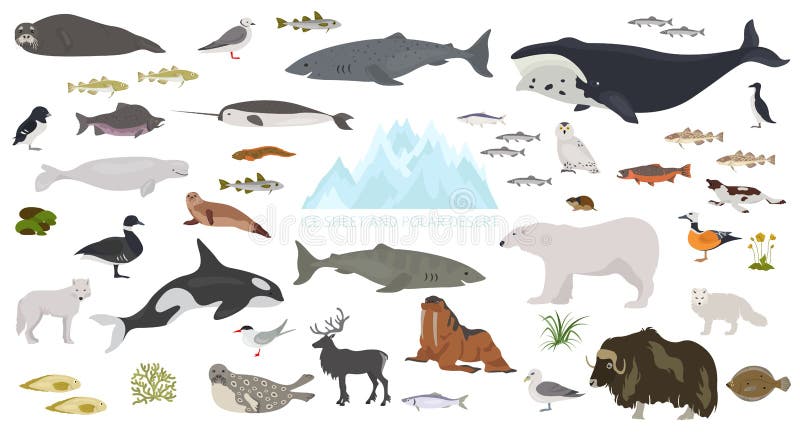
Free with trial Ice sheet and polar desert biome. Terrestrial ecosystem world map. Arctic animals, birds, fish and plants seamless pattern design. Vector illustration. Desert biome map vectors Ice sheet and polar desert biome. Terrestrial ecosystem world map. Arctic animals, birds, fish and plants seamless pattern design
Free with trial Desert biome, xeric shrubland biome, natural region seamless pattern. Terrestrial ecosystem world map. Animals, birds and vegetations design set. Vector illustration. Desert biome map vectors Desert biome, xeric shrubland biome, natural region seamless pattern. Terrestrial ecosystem world map. Animals, birds and
Free with trial Ice sheet and polar desert biome. Terrestrial ecosystem world map. Arctic animals, birds, fish and plants seamless pattern design. Vector illustration. Desert biome map vectors Ice sheet and polar desert biome. Terrestrial ecosystem world map. Arctic animals, birds, fish and plants seamless pattern design
Free with trial Ice sheet and polar desert biome. Terrestrial ecosystem world map. Arctic animals, birds, fish and plants infographic design. Vector illustration. Desert biome map illustrations Ice sheet and polar desert biome. Terrestrial ecosystem world map. Arctic animals, birds, fish and plants infographic design
Free with trial Desert biome, xeric shrubland natural region infographic. Terrestrial ecosystem world map. Animals, birds and vegetations design set. Vector illustration. Desert biome map vectors Desert biome, xeric shrubland natural region infographic. Terrestrial ecosystem world map. Animals, birds and vegetations design
Free with trial Desert biome, xeric shrubland natural region infographic. Terrestrial ecosystem world map. Animals, birds and vegetations design set. Vector illustration. Desert biome map vectors Desert biome, xeric shrubland natural region infographic. Terrestrial ecosystem world map. Animals, birds and vegetations design
Free with trial Desert biome, xeric shrubland biome, natural region infographic. Terrestrial ecosystem world map. Animals, birds and vegetations isometric design set. Vector illustration. Desert biome map vectors Desert biome, xeric shrubland biome, natural region infographic. Terrestrial ecosystem world map. Animals, birds and vegetations
Free with trial Diverse ecosystem illustration collection on isolated background. Modern gradient style education design includes jungle, desert and snow environment bubbles. Desert biome map vectors Diverse environment ecosystem illustration set. Diverse ecosystem illustration collection on isolated background. Modern gradient style education design includes jungle, desert and snow environment bubbles