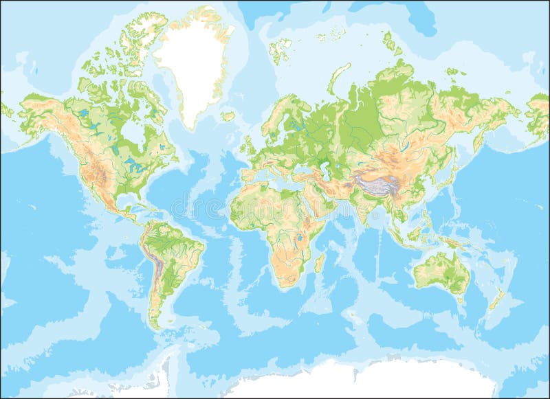
Free with trial Geological global earth map in colors. Geological global earth map illustrations Map of the world. Geological global earth map in colors
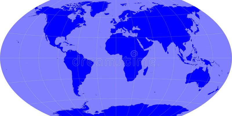
Free with trial Earth map - winkle projection with grids. Geological global earth map illustrations Earth map
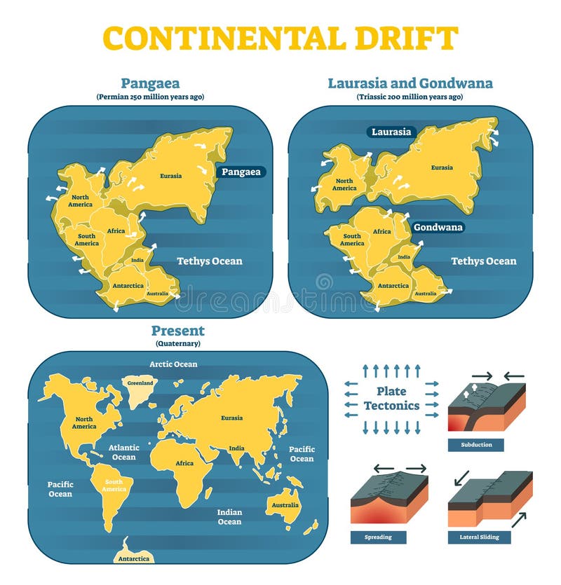
Free with trial Continental drift chronological movement, historical timeline with earth continents: Pangaea, Laurasia, Gondwana. Vector illustration world map. Geological global earth map vectors Continental drift chronological movement, historical timeline with earth continents: Pangaea, Laurasia, Gondwana.
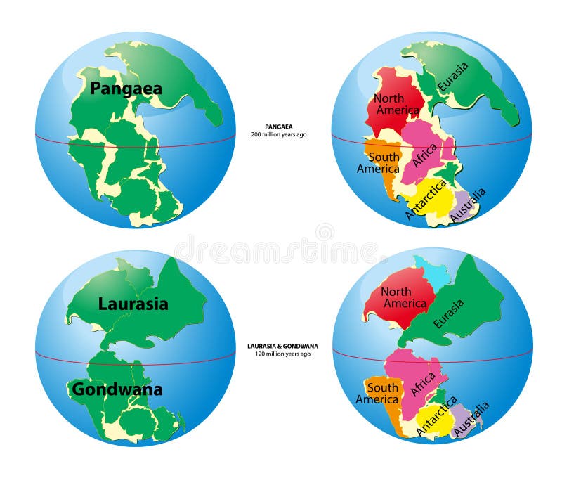
Free with trial World map of Pangaea - 200 million years ago, Laurasia, Gondwana - 120 million years ago. Geological global earth map vectors World map of Pangaea, Laurasia, Gondwana. World map of Pangaea - 200 million years ago, Laurasia, Gondwana - 120 million years ago.
Free with trial An abstract, overhead view of a world map rendered with a striking cracked earth texture. The continents appear as light, dry, and fractured landmasses against a dark, rough, and deeply textured background representing the oceans. This unique geological representation evokes themes of environmental fragility, climate change, drought, and global challenges, offering a powerful visual for topics related to ecology, sustainability, and the planet's future. Geological global earth map illustrations Cracked Earth World Map Texture. An abstract, overhead view of a world map rendered with a striking cracked earth texture. The continents appear as light, dry, and fractured landmasses against a dark, rough, and deeply textured background representing the oceans. This unique geological representation evokes themes of environmental fragility, climate change, drought, and global challenges, offering a powerful visual for topics related to ecology, sustainability, and the planet's future.
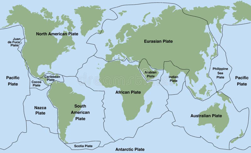
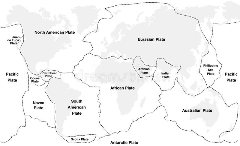
Free with trial Tectonic plates of planet earth - map with names of major an minor plates. Geological global earth map vectors Tectonic Plates
Free with trial Earth geological section. 3d rendered image. Geological global earth map illustrations Earth
Free with trial The image represents an isometric 3d map of a mountain with rocks and terrain. Geological global earth map illustrations 3d map isometric of mountain with rocks and terrain. The image represents an isometric 3d map of a mountain with rocks and terrain
Free with trial A powerful vector illustration showing seismic activity indicated by radiating waves on a world map, symbolizing earthquake monitoring and global risk. This graphic is ideal for geological studies, disaster preparedness, scientific reports, or any design conveying earth sciences, natural hazards, and the global impact of tectonic movements, vector design Generative AI. Geological global earth map vectors Seismic Activity on World Map, Earthquake Monitoring, Global Risk, vector design Generative AI. A powerful vector illustration showing seismic activity indicated by radiating waves on a world map, symbolizing earthquake monitoring and global risk. This graphic is ideal for geological studies, disaster preparedness, scientific reports, or any design conveying earth sciences, natural hazards, and the global impact of tectonic movements, vector design Generative AI
Free with trial Tectonic Plates on the planet Earth. modern continents and tectonic plates infographics Set of icons Earth. Geological global earth map vectors Tectonic Plates on the planet Earth. modern continents and infographics Set of icons Flat style. Tectonic Plates on the planet Earth. modern continents and tectonic plates infographics Set of icons Earth
Free with trial 3d Illustration of Earth structure isolated on black. Crust, upper mantle, lower mantle, outer core and inner core. Earth cutaway. Layered Earth. Geological global earth map illustrations Earth structure isolated on black. Crust, upper mantle, lower , outer core and inner . cutaway. Layered . 3d Illustration of Earth structure isolated on black. Crust, upper mantle, lower mantle, outer core and inner core. Earth cutaway. Layered Earth.
Free with trial Tectonic Plates on the planet Earth. modern continents and tectonic plates infographics Set of icons Earth. Geological global earth map vectors Tectonic Plates on the planet Earth. modern continents and infographics Set of icons Flat style. Tectonic Plates on the planet Earth. modern continents and tectonic plates infographics Set of icons Earth
Free with trial AI image of a meticulously crafted relief world map showcasing continents oceans and intricate geological details. This artistic visualization of Earth presents a compelling view of global. Generative AI image , minimalist background. Geological global earth map illustrations AI image Relief world map showing continents oceans and geological details artistic visualization. AI image of a meticulously crafted relief world map showcasing continents oceans and intricate geological details. This artistic visualization of Earth presents a compelling view of global . Generative AI image , minimalist background
Free with trial Watercolor map of the world isolated on white. Geological global earth map vectors Watercolor map of the world isolated
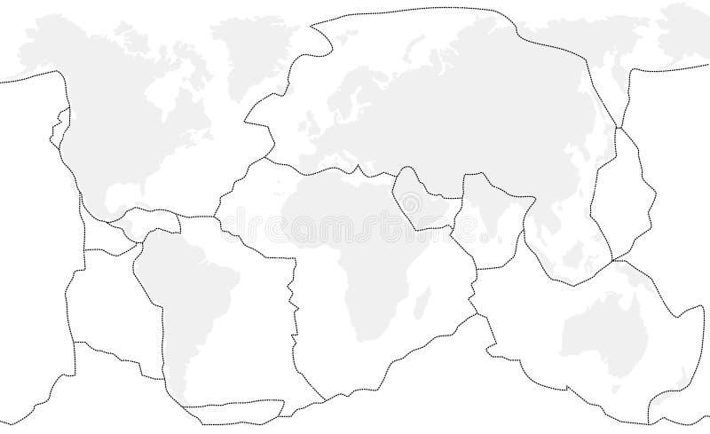
Free with trial Tectonic plates unlabeled - world map with fault lines of major an minor plates. Geological global earth map vectors Tectonic Plates Unlabeled
Free with trial Plate tectonics - world map with major an minor plates. Vector illustration. Geological global earth map vectors Plate Tectonics
Free with trial A blue globe representing the Earth with a map, symbolizing our planet and global connections. Geological global earth map illustrations Blue Globe Earth Planet World Map. A blue globe representing the Earth with a map, symbolizing our planet and global connections
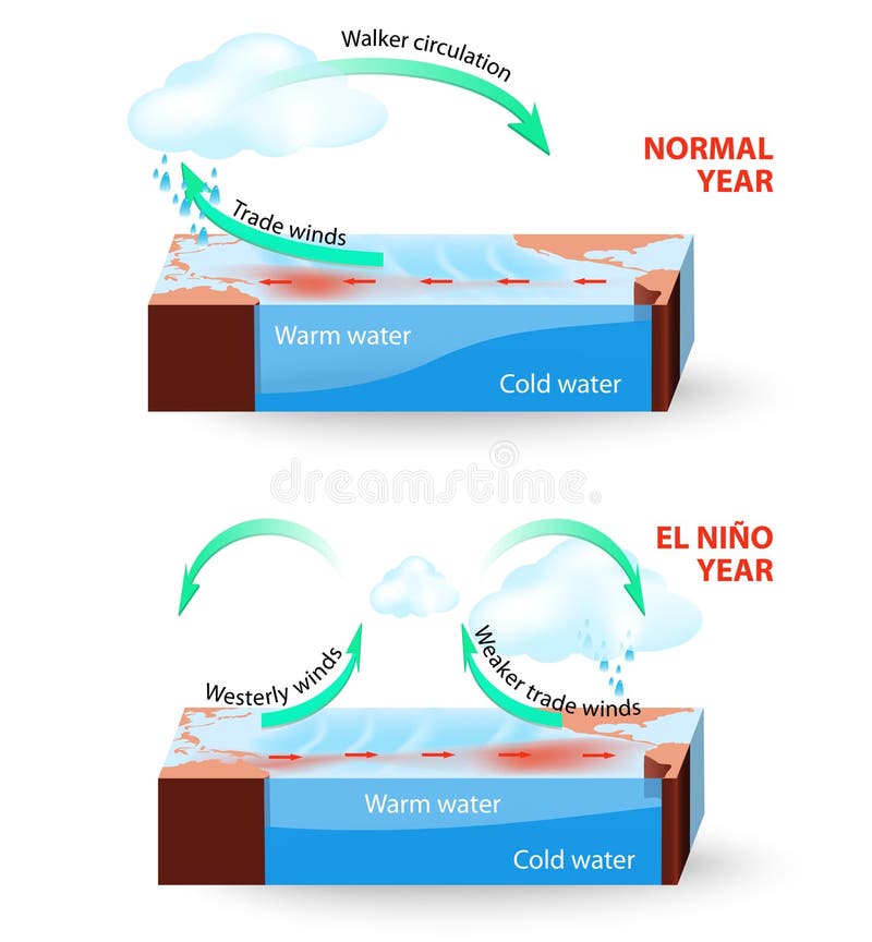
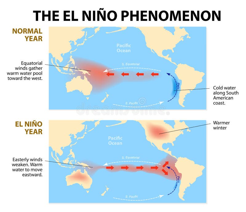
Free with trial El Nino Southern Oscillation (ENSO) is a global phenomenon in ocean and atmosphere. For an unknown reason El Nino events occur irregularly at intervals once every 2-7 years. The effects of El Niño mess up normal winter conditions throughout the Pacific Ocean and change global weather patterns and disrupt fisheries worldwide. Geological global earth map vectors Vector infographic. Cross section of El Nino South. El Nino Southern Oscillation (ENSO) is a global phenomenon in ocean and atmosphere. For an unknown reason El Nino events occur irregularly at intervals once every 2-7 years. The effects of El Niño mess up normal winter conditions throughout the Pacific Ocean and change global weather patterns and disrupt fisheries worldwide.
Free with trial Plate tectonics - planet earth with major an minor plates - GERMAN LABELING! Vector illustration. Geological global earth map vectors Plate Tectonics German. Plate tectonics - planet earth with major an minor plates - GERMAN LABELING! Vector illustration.
Free with trial Tectonic plates with names - world map with fault lines of major an minor plates. Geological global earth map vectors Tectonic Plates Names. Tectonic plates with names - world map with fault lines of major an minor plates.
Free with trial This image depicts a global map illustrating the concept of continental drift. It highlights the positions of the continents before they separated and drifted to their current locations. The map uses color gradients to represent different landmasses and oceanic regions, providing a visual representation of the Earth's geological history. Geological global earth map illustrations Global map showing continental drift. This image depicts a global map illustrating the concept of continental drift. It highlights the positions of the continents before they separated and drifted to their current locations. The map uses color gradients to represent different landmasses and oceanic regions, providing a visual representation of the Earth's geological history
Free with trial An illustration melting globe symbolizing global warming. Geological global earth map vectors Vector Globe. An illustration melting globe symbolizing global warming.
Free with trial Diagram shows the El Nino phenomenon. El Niño is a disruption of the ocean and atmosphere system in the Pacific ocean having important consequences for weather around the globe. Geological global earth map vectors El nino phenomenon
Free with trial An illustration globe sinking in the water symbolizing global warming. Geological global earth map vectors Vector Globe. An illustration globe sinking in the water symbolizing global warming.
Free with trial Vector illustration of a geologist. Geological global earth map illustrations Geology illustration series. Vector illustration of a geologist.
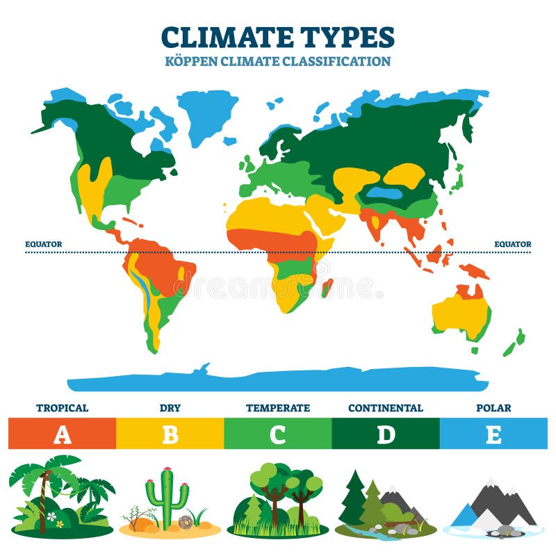
Free with trial Climate types vector illustration. Labeled classification educational scheme with tropical, dry, temperate, continental and polar sections. Koppen geographical and geological planet ecosystem example. Geological global earth map vectors Climate type vector illustration. Labeled classification educational scheme. Climate types vector illustration. Labeled classification educational scheme with tropical, dry, temperate, continental and polar sections. Koppen geographical and geological planet ecosystem example.
Free with trial Vector illustration of a geologist with a globe and volcano crater scale models. Geological global earth map illustrations Geology illustration series. Vector illustration of a geologist with a globe and volcano crater scale models.
Free with trial The image displays a world map with various regions highlighted in different colors, indicating diverse ecological, geological, or thematic data. Surrounding the globe are magnified circular insets showcasing detailed views of specific areas, each with unique patterns and color gradients. These close-ups likely represent specific data points like land use, vegetation, climate zones, or geological. Geological global earth map illustrations Global map with highlighted regions showing diverse ecological and geological data. The image displays a world map with various regions highlighted in different. The image displays a world map with various regions highlighted in different colors, indicating diverse ecological, geological, or thematic data. Surrounding the globe are magnified circular insets showcasing detailed views of specific areas, each with unique patterns and color gradients. These close-ups likely represent specific data points like land use, vegetation, climate zones, or geological
Free with trial Geopolitics word cloud shape concept. Geological global earth map illustrations Geopolitics word cloud shape
Free with trial Tectonic plates fit together to make up Earth’s surface. These plates move, bump together, overlap, and slide past each other, in the process making new areas of ocean floor, building mountains, causing earthquakes, and creating volcanoes. 3d rendering. Element of this image are furnished by Nasa. Geological global earth map illustrations Tectonic plates move constantly, making new areas of ocean floor, building mountains, causing earthquakes, and creating volcanoes. Tectonic plates fit together to make up Earth’s surface. These plates move, bump together, overlap, and slide past each other, in the process making new areas of ocean floor, building mountains, causing earthquakes, and creating volcanoes. 3d rendering. Element of this image are furnished by Nasa
Free with trial Tectonic plates fit together to make up Earth’s surface. These plates move, bump together, overlap, and slide past each other, in the process making new areas of ocean floor, building mountains, causing earthquakes, and creating volcanoes. 3d rendering. Element of this image are furnished by Nasa. North America. Geological global earth map illustrations Tectonic plates move constantly, making new areas of ocean floor, building mountains, causing earthquakes, and creating volcanoes. Tectonic plates fit together to make up Earth’s surface. These plates move, bump together, overlap, and slide past each other, in the process making new areas of ocean floor, building mountains, causing earthquakes, and creating volcanoes. 3d rendering. Element of this image are furnished by Nasa. North America
Free with trial A striking vector illustration depicting a global earthquake, with cracks radiating from a central point on the earth, symbolizing seismic activity and world disaster. This graphic is ideal for educational materials, emergency preparedness, or any design conveying geological impact, natural forces, and the global scale of earth's powerful movements, vector design Generative AI. Geological global earth map vectors Global Earthquake, Seismic Activity, World Disaster, Geological Impact, vector design Generative AI. A striking vector illustration depicting a global earthquake, with cracks radiating from a central point on the earth, symbolizing seismic activity and world disaster. This graphic is ideal for educational materials, emergency preparedness, or any design conveying geological impact, natural forces, and the global scale of earth's powerful movements, vector design Generative AI
Free with trial Tectonic plates fit together to make up Earth’s surface. These plates move, bump together, overlap, and slide past each other, in the process making new areas of ocean floor, building mountains, causing earthquakes, and creating volcanoes. 3d rendering. Element of this image are furnished by Nasa. Geological global earth map illustrations Tectonic plates move constantly, making new areas of ocean floor, building mountains, causing earthquakes, and creating volcanoes. Tectonic plates fit together to make up Earth’s surface. These plates move, bump together, overlap, and slide past each other, in the process making new areas of ocean floor, building mountains, causing earthquakes, and creating volcanoes. 3d rendering. Element of this image are furnished by Nasa
Free with trial Yellow safety helmet on pile of coal with world map. Idea of carbon footprint on earth. Concept for mining industry impact, on global eco. Pollution and resources consumption. Geological global earth map illustrations Yellow safety helmet on pile of coal with world map. Idea of carbon footprint on earth. Concept for mining industry impact on. Yellow safety helmet on pile of coal with world map. Idea of carbon footprint on earth. Concept for mining industry impact, on global eco. Pollution and resources consumption.
Free with trial Detailed earth physical map from space with mountain ranges, valleys, water bodies in global view, Generated by AI. Geological global earth map illustrations Detailed earth physical map from space with mountain ranges, valleys, water bodies in global view
Free with trial Detailed earth view physical map over global satellite photo reveals terrain features from space, Generated by AI. Geological global earth map illustrations Detailed earth view physical map over global satellite photo reveals terrain features from space
Free with trial This graphic illustrates a flat, simplified world map featuring all major continents and landmasses. The land areas are uniformly colored in a neutral gray tone against a pure white background, providing a clean design ideal for graphic use Rendered by Ai for versatility. It is a fundamental representation of global geography suitable for presentations, educational materials, and design projects. Geological global earth map illustrations Simple modern vector map of the global continents. This graphic illustrates a flat, simplified world map featuring all major continents and landmasses. The land areas are uniformly colored in a neutral gray tone against a pure white background, providing a clean design ideal for graphic use Rendered by Ai for versatility. It is a fundamental representation of global geography suitable for presentations, educational materials, and design projects
Free with trial This captivating detailed earth map offers a comprehensive view of our planet intricate geographical features. From the towering mountain ranges to the vast ocean depths, the image showcases the Earth diverse topography in stunning detail. The intricate patterns of landmasses and contours, along with the vibrant blue of the oceans, create a breathtaking visual representation of global geography. Geological global earth map illustrations Detailed Global Earth Map A Stunning Visual Exploration of Planet Earths Geography and Continents. This captivating detailed earth map offers a comprehensive view of our planet intricate geographical features. From the towering mountain ranges to the vast ocean depths, the image showcases the Earth diverse topography in stunning detail. The intricate patterns of landmasses and contours, along with the vibrant blue of the oceans, create a breathtaking visual representation of global geography
Free with trial Set line Mining dump truck Ground Ore mining Global planet with bulb Geological fault Topographic map Earth core structure crust and globe and book icon. Vector. Geological global earth map vectors Set line Mining dump truck, Ground, Ore mining, Global planet with bulb, Geological fault, Topographic map, Earth core. Set line Mining dump truck Ground Ore mining Global planet with bulb Geological fault Topographic map Earth core structure crust and globe and book icon. Vector.
Free with trial Set Archeology Topographic map Compass Earth core structure crust Soil analysis Geological fault and Global planet with bulb icon. Vector. Geological global earth map illustrations Set Archeology, Topographic map, Compass, Earth core structure crust, Soil analysis, Geological fault and Global planet. Set Archeology Topographic map Compass Earth core structure crust Soil analysis Geological fault and Global planet with bulb icon. Vector.
Free with trial An awe-inspiring conceptual image featuring a world map crafted from vibrant, sparkling gemstone-like crystals, floating on a dark, reflective surface. The continents are distinctly colored: red for Africa, green for South America, yellow for Asia and Australia, and various shades of white and grey for other regions. This intricate map is set within a breathtaking natural cave, adorned with ancient stalactites and stalagmites, with a distant light source hinting at discovery. It symbolizes global natural resources, geological wonders, and the hidden treasures of our planet. Geological global earth map illustrations Earth\'s Gemstone Map in a Mystical Cave. An awe-inspiring conceptual image featuring a world map crafted from vibrant, sparkling gemstone-like crystals, floating on a dark, reflective surface. The continents are distinctly colored: red for Africa, green for South America, yellow for Asia and Australia, and various shades of white and grey for other regions. This intricate map is set within a breathtaking natural cave, adorned with ancient stalactites and stalagmites, with a distant light source hinting at discovery. It symbolizes global natural resources, geological wonders, and the hidden treasures of our planet.
Free with trial A scientific vector illustration depicting the Earth's layers alongside a globe, explaining geological structure. Ideal for educational materials, environmental science, or research presentations. Represents planetary composition and natural processes, perfect for illustrating earth science concepts and global studies, vector design Generative AI. Geological global earth map vectors Earth Layers and Globe Vector, Geological Science Art, vector design Generative AI. A scientific vector illustration depicting the Earth's layers alongside a globe, explaining geological structure. Ideal for educational materials, environmental science, or research presentations. Represents planetary composition and natural processes, perfect for illustrating earth science concepts and global studies, vector design Generative AI
Free with trial A striking black and white conceptual illustration featuring a human silhouette sitting across a world map, primarily over Africa. The map is overlaid with various scientific and historical terms like "Biodiversity Hotspot," "Tectonic Plates," and "Ancient Sclietions," creating a thought-provoking visual. This graphic image explores themes of humanity's connection to the Earth, environmental impact, geology, and global history. Generated by AI. Geological global earth map vectors Human Silhouette on World Map with Geological and Ecological Labels. A striking black and white conceptual illustration featuring a human silhouette sitting across a world map, primarily over Africa. The map is overlaid with various scientific and historical terms like "Biodiversity Hotspot," "Tectonic Plates," and "Ancient Sclietions," creating a thought-provoking visual. This graphic image explores themes of humanity's connection to the Earth, environmental impact, geology, and global history. Generated by AI
Free with trial A detailed earth map image showcasing continents oceans and geographical features. perfect for educational purposes design projects or anyone interested in global geography and exploration. vivid colors and textures. Geological global earth map illustrations Detailed earth map image showcasing continents oceans and geographical features for education and design use. a detailed earth map image showcasing continents oceans and geographical features. perfect for educational purposes design projects or anyone interested in global geography and exploration. vivid colors and textures.
Free with trial A close-up shot of a person's hands typing on a laptop keyboard, engaged in advanced geological data analysis. The screen displays a sophisticated interface with a 3D topographic map illustrating 'NICKEL LATERITE RESOURCE ESTIMATION' alongside various 'GEOPHYSICAL PROFILE' charts and graphs. This image represents modern scientific research, mining exploration, and the application of big data analytics in earth sciences. It conveys concepts of technology, resource management, and strategic planning for mineral extraction, highlighting the digital transformation in geological surveys and environmental assessment. Geological global earth map illustrations Advanced Geological Resource Estimation on Laptop Screen. A close-up shot of a person's hands typing on a laptop keyboard, engaged in advanced geological data analysis. The screen displays a sophisticated interface with a 3D topographic map illustrating 'NICKEL LATERITE RESOURCE ESTIMATION' alongside various 'GEOPHYSICAL PROFILE' charts and graphs. This image represents modern scientific research, mining exploration, and the application of big data analytics in earth sciences. It conveys concepts of technology, resource management, and strategic planning for mineral extraction, highlighting the digital transformation in geological surveys and environmental assessment.
Free with trial A stylized world map rendered with a lava-like texture and glowing outlines, set against a dark, cracked earth background. The continents are defined by bright orange and yellow lines, creating a dramatic and fiery visual. Suitable for concepts related to climate change, global warming, geological events, or a dystopian future. Geological global earth map illustrations Lava World Map. A stylized world map rendered with a lava-like texture and glowing outlines, set against a dark, cracked earth background. The continents are defined by bright orange and yellow lines, creating a dramatic and fiery visual. Suitable for concepts related to climate change, global warming, geological events, or a dystopian future.
Free with trial Delve into the dynamic processes shaping our planet with this captivating map of Earth's tectonic plates. Rendered using the Kavrayskiy VII projection, this detailed global geological representation showcases the intricate network of plates that constantly move, collide, and diverge. Observe the vibrant color-coding that distinguishes various plate boundaries, including divergent, convergent,. Geological global earth map illustrations A Vibrant Visualization of Earths Tectonic Plates Global Geology Map with Kavrayskiy VII Projection. Delve into the dynamic processes shaping our planet with this captivating map of Earth's tectonic plates. Rendered using the Kavrayskiy VII projection, this detailed global geological representation showcases the intricate network of plates that constantly move, collide, and diverge. Observe the vibrant color-coding that distinguishes various plate boundaries, including divergent, convergent,
Free with trial A close-up shot of a person's hands typing on a laptop keyboard, with the screen displaying intricate geophysical data visualizations. The interface features a prominent "Magnetic Anomaly" map, a "Geophysical Map," and a "Geophysic Survey" with various charts, graphs, and 3D terrain models. This image represents advanced scientific research, geological exploration, and data analysis using cutting-edge software. It conveys concepts of big data interpretation, environmental studies, resource mapping, and technological innovation in earth sciences. Ideal for illustrating scientific computing, engineering, and professional analysis. Geological global earth map illustrations Geophysical Data Analysis on Laptop Screen with Magnetic Anomaly Map. A close-up shot of a person's hands typing on a laptop keyboard, with the screen displaying intricate geophysical data visualizations. The interface features a prominent "Magnetic Anomaly" map, a "Geophysical Map," and a "Geophysic Survey" with various charts, graphs, and 3D terrain models. This image represents advanced scientific research, geological exploration, and data analysis using cutting-edge software. It conveys concepts of big data interpretation, environmental studies, resource mapping, and technological innovation in earth sciences. Ideal for illustrating scientific computing, engineering, and professional analysis.
Free with trial Explore the breathtaking topography of our planet with this detailed 3D earth map. The exaggerated relief showcases the dramatic variations in elevation, highlighting the towering peaks of mountain ranges, the deep trenches of ocean basins, and the vast plateaus and plains that shape the Earth's surface. This interactive visualization provides a unique perspective on the global landscape,. Geological global earth map illustrations Unveiling Earths Dramatic Topography A 3D Map Exaggerates Mountain Ranges Ocean Depths and Global Relief. Explore the breathtaking topography of our planet with this detailed 3D earth map. The exaggerated relief showcases the dramatic variations in elevation, highlighting the towering peaks of mountain ranges, the deep trenches of ocean basins, and the vast plateaus and plains that shape the Earth's surface. This interactive visualization provides a unique perspective on the global landscape,
Free with trial Earth core structure with geological layers 3d rendering, three-dimensional object isolated illustration on white background. Geological global earth map illustrations Earth core structure with geological layers 3d rendering
Free with trial Over-the-shoulder view of a professional analyzing complex geological data on a laptop. The screen displays an advanced dashboard featuring a 3D topographical map illustrating 'PHOSPHATE FORMATION' and 'MINING BOUNDERY', alongside various interactive charts, graphs, and time series data. This visual represents modern resource exploration, environmental monitoring, and data-driven decision-making in geology, mining, and earth sciences. Ideal for themes of digital transformation, business intelligence, and scientific research. Geological global earth map illustrations Geological Data Analysis on Laptop: Mining and Phosphate Formation Dashboard. Over-the-shoulder view of a professional analyzing complex geological data on a laptop. The screen displays an advanced dashboard featuring a 3D topographical map illustrating 'PHOSPHATE FORMATION' and 'MINING BOUNDERY', alongside various interactive charts, graphs, and time series data. This visual represents modern resource exploration, environmental monitoring, and data-driven decision-making in geology, mining, and earth sciences. Ideal for themes of digital transformation, business intelligence, and scientific research.
Free with trial An illustration showcasing the Earth's geological layers and ocean currents. The layers are depicted in a block shape beneath the surface of the ocean, displaying various colors that represent different geological properties. Ocean currents are illustrated with colorful lines flowing over the global map, creating a dynamic and informative graphic. The underwater setting is conveyed by the deep , fresh composition. Geological global earth map illustrations Earths geological layers and ocean currents. An illustration showcasing the Earth's geological layers and ocean currents. The layers are depicted in a block shape beneath the surface of the ocean, displaying various colors that represent different geological properties. Ocean currents are illustrated with colorful lines flowing over the global map, creating a dynamic and informative graphic. The underwater setting is conveyed by the deep , fresh composition
Free with trial Essential tools for a geological expedition are laid out across a world map, symbolizing the planning and research phase of a global adventure. A hammer, compass, and magnifying glass await the start of a journey of discovery, mapping new territories and uncovering the Earths secrets. Geological global earth map illustrations Geological Survey and Cartography Concept. Essential tools for a geological expedition are laid out across a world map, symbolizing the planning and research phase of a global adventure. A hammer, compass, and magnifying glass await the start of a journey of discovery, mapping new territories and uncovering the Earths secrets
Free with trial View of the world map displaying geographical continents and a volcano eruption illustration showing inside earth layers Perfect for scientific or educational usage. Geological global earth map illustrations World Map with Volcano Showing Earth Layers. View of the world map displaying geographical continents and a volcano eruption illustration showing inside earth layers Perfect for scientific or educational usage
Free with trial Earth satellite, space station, planet satellite map, astronaut, space rocket, spacecraft, extraterrestrial space, celestial body, astronomical map, world communication ring, spherical star system spacecraft, interstellar space, interstellar travel, star planets, Milky Way, solar system, information age, urban bird's-eye view, earth terrain image, geological exploration, high-altitude photography, Earth satellite, high-altitude geography, Earth photography, world view, global terrain mapping, topographic map, technological background, land and ocean. Geological global earth map illustrations Human technological exploration of the universe, artificial satellite space illustration. Earth satellite, space station, planet satellite map, astronaut, space rocket, spacecraft, extraterrestrial space, celestial body, astronomical map, world communication ring, spherical star system spacecraft, interstellar space, interstellar travel, star planets, Milky Way, solar system, information age, urban bird's-eye view, earth terrain image, geological exploration, high-altitude photography, Earth satellite, high-altitude geography, Earth photography, world view, global terrain mapping, topographic map, technological background, land and ocean
Free with trial A 3D rendering depicts a world map with a central, wave-like geological formation composed of multiple layers of black and white rocks arranged in a curved pattern that creates depth and dimension, featuring a prominent red line running through its middle against a light blue background with scattered small islands and bodies of water, utilizing a predominantly blue and white color scheme with. Geological global earth map illustrations A 3D rendered world map with a futuristic geological wave structure made of layered black and white rocks and a red line. A 3D rendering depicts a world map with a central, wave-like geological formation composed of multiple layers of black and white rocks arranged in a curved pattern that creates depth and dimension, featuring a prominent red line running through its middle against a light blue background with scattered small islands and bodies of water, utilizing a predominantly blue and white color scheme with
Free with trial Illustration of global plate tectonics highlights Earth's dynamic crust, showing major tectonic plates and boundaries. The map includes North America, South America, Eurasia, and Africa, with marked divergent, convergent, and transform boundaries. Volcanoes are shown along plate edges, indicating active regions like the "Ring of Fire" and the Mid-Atlantic Ridge. The accompanying section illustrates subduction zones, mantle convection, and continental drift processes. Labels clarify tectonic activities, emphasizing the interconnectedness of Earth's surface and dynamic geological processes. Geological global earth map illustrations Global Plate Tectonics: Visualize Earth\'s dynamic crust, plate boundaries, volcanoes, and continental drift. Illustration of global plate tectonics highlights Earth's dynamic crust, showing major tectonic plates and boundaries. The map includes North America, South America, Eurasia, and Africa, with marked divergent, convergent, and transform boundaries. Volcanoes are shown along plate edges, indicating active regions like the "Ring of Fire" and the Mid-Atlantic Ridge. The accompanying section illustrates subduction zones, mantle convection, and continental drift processes. Labels clarify tectonic activities, emphasizing the interconnectedness of Earth's surface and dynamic geological processes.
Free with trial Panoramic coastal terrain map showing detailed Gulf of America elevation data created by geographers for professional earth science visualization projects and environmental research presentations. Geological global earth map illustrations Panoramic coastal terrain map showing detailed Gulf of America elevation data created by geographers for professional earth
Free with trial A colorful world map displays global temperature variations with orange hues for warmer regions and blue tones for cooler areas, also depicting ocean bathymetry in shades of light blue. Geological global earth map illustrations Vibrant world map showing global temperature distribution with ocean depths isolated on white background. A colorful world map displays global temperature variations with orange hues for warmer regions and blue tones for cooler areas, also depicting ocean bathymetry in shades of light blue
Free with trial A low-saturation, illustrative globe map displaying the major continents and oceans of Earth. The continents are shaded in green, the oceans in blue, and the map is oriented with the Americas on the left and Europe, Africa, and Asia on the right. The image appears to be a stylized representation without country borders, emphasizing the planet's geography. Geological global earth map illustrations Global map showing earth\'s surface with continents and oceansground. A low-saturation, illustrative globe map displaying the major continents and oceans of Earth. The continents are shaded in green, the oceans in blue, and the map is oriented with the Americas on the left and Europe, Africa, and Asia on the right. The image appears to be a stylized representation without country borders, emphasizing the planet's geography
Free with trial This historical visualization presents a three-section topographic world map analysis spanning 1954 to 1985, featuring a detailed line graph that tracks the evolution of global topographical features through time using curved wave-like patterns in contrasting shades of green, blue, and purple to represent different Earth regions and trends, with the green line specifically denoting topography, the. Geological global earth map illustrations Historical topographic world map line graph showing geographical features evolution from 1954 to 1985 with colorful waveform. This historical visualization presents a three-section topographic world map analysis spanning 1954 to 1985, featuring a detailed line graph that tracks the evolution of global topographical features through time using curved wave-like patterns in contrasting shades of green, blue, and purple to represent different Earth regions and trends, with the green line specifically denoting topography, the
Free with trial Schematic illustration showing abstract cut geological earth layers with minerals. Oil pump tower, production well drilling deep underground. Includes infographics for education on. Geological global earth map illustrations Schematic illustration showing abstract cut geological earth layers with minerals. Oil pump tower, production well drilling deep