Free with trial Isolated silver planet Earth. Glossy golden land. Metal atlas. PNG with transparent background. Highlighted iraq map vectors Brushed steel 3D globe gold earth crust. Isolated silver planet Earth. Glossy golden land. Metal atlas. PNG with transparent background.
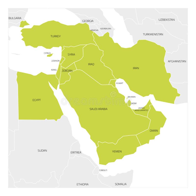
Free with trial Map of Middle East or Near East transcontinental region with green highlighted Western Asia countries, Turkey, Cyprus and Egypt. Flat map with thin white state borders. Highlighted iraq map vectors Map of Middle East region. Map of Middle East or Near East transcontinental region with green highlighted Western Asia countries, Turkey, Cyprus and Egypt. Flat map with thin white state borders.
Free with trial Map of Middle East or Near East transcontinental region with highlighted Western Asia countries, Turkey, Cyprus and Egypt. Flat grey map with country thin black borders. Highlighted iraq map vectors Map of Middle East region. Map of Middle East or Near East transcontinental region with highlighted Western Asia countries, Turkey, Cyprus and Egypt. Flat grey map with country thin black borders.
Free with trial Highlighted map of IRAQ inside detailed blank flat political map of the Asian continent on isolated background. Highlighted iraq map vectors Highlighted map of IRAQ inside political map of the Asian continent. Highlighted map of IRAQ inside detailed blank flat political map of the Asian continent on isolated background
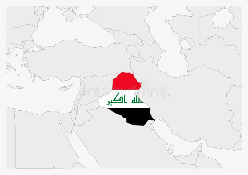
Free with trial Iraq map highlighted in Iraq flag colors, gray map with neighboring countries. Highlighted iraq map vectors Iraq map highlighted in Iraq flag colors
Free with trial Iraq map highlighted in Iraq flag colors and pin of country capital Baghdad, map with neighboring Asian countries. Highlighted iraq map vectors Iraq map highlighted in Iraq flag colors and pin of country capital Baghdad
Free with trial Map of Middle East or Near East transcontinental region with green highlighted Turkey, Syria, Iraq, Jordan, Lebanon and Israel. Flat map with thin white state borders. Highlighted iraq map vectors Map of Middle East region. Map of Middle East or Near East transcontinental region with green highlighted Turkey, Syria, Iraq, Jordan, Lebanon and Israel. Flat map with thin white state borders.
Free with trial Map of Middle East or Near East transcontinental region with orange highlighted Turkey, Syria, Iraq, Jordan, Lebanon and Israel. Flat map with yellow land, thin black borders and blue sea. Highlighted iraq map vectors Map of Middle East region. Map of Middle East or Near East transcontinental region with orange highlighted Turkey, Syria, Iraq, Jordan, Lebanon and Israel. Flat map with yellow land, thin black borders and blue sea.
Free with trial OPEC, Organization of the Petroleum Exporting Countries. World map with pink highlighted member states since 2017. Vector illustration. Highlighted iraq map vectors OPEC, Organization of the Petroleum Exporting Countries. World map with pink highlighted member states since 2017
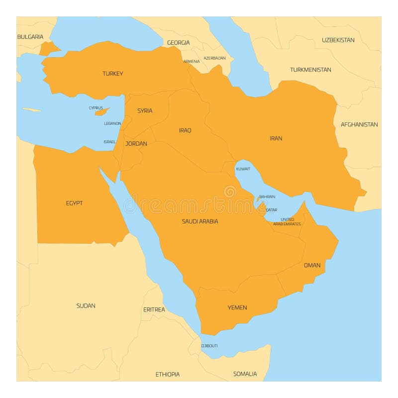
Free with trial Map of Middle East or Near East transcontinental region with orange highlighted Western Asia countries, Turkey, Cyprus and Egypt. Flat map with yellow land, thin black borders and blue sea. Highlighted iraq map vectors Map of Middle East region. Map of Middle East or Near East transcontinental region with orange highlighted Western Asia countries, Turkey, Cyprus and Egypt. Flat map with yellow land, thin black borders and blue sea.
Free with trial Sunset above Iraq from space on planet Earth with visible country borders. 3D illustration. Elements of this image furnished by NASA. Highlighted iraq map illustrations Iraq from space during sunrise. Sunset above Iraq from space on planet Earth with visible country borders. 3D illustration. Elements of this image furnished by NASA.
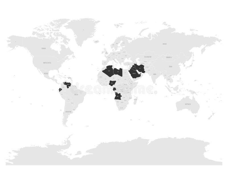
Free with trial OPEC, Organization of the Petroleum Exporting Countries. World map with black highlighted member states since 2017. Vector illustration. Highlighted iraq map vectors OPEC, Organization of the Petroleum Exporting Countries. World map
Free with trial Close-up of the Iran border area on a topographic map. Capital point. Outline around the country shape. Highlighted iraq map illustrations Shape of Iran. Outlined. Topographic. Close-up of the Iran border area on a topographic map. Capital point. Outline around the country shape.
Free with trial Close-up of the Iran border area on a satellite map. Capital point. Outline around the country shape. Highlighted iraq map illustrations Shape of Iran. Outlined. Satellite. Close-up of the Iran border area on a satellite map. Capital point. Outline around the country shape.
Free with trial OPEC, Organization of the Petroleum Exporting Countries. World map with pink highlighted member states since 2017. Vector illustration. Highlighted iraq map vectors OPEC, Organization of the Petroleum Exporting Countries.
Free with trial Iraq highlighted in with red glowing borders on a night map with city lights. Elements of this image furnished by ESA. Highlighted iraq map illustrations Iraq highlighted on night map. Iraq highlighted in with red glowing borders on a night map with city lights. Elements of this image furnished by ESA.
Free with trial Dahūk Map is highlighted on the Iraq map with detailed state and region outlines n. Highlighted iraq map illustrations Dahūk Map is highlighted on the Iraq map with detailed state and region outlines
Free with trial Iraq highlighted in red on a realistic map with country borders. Elements of this image furnished by ESA. Highlighted iraq map illustrations Iraq highlighted on realistic map. Iraq highlighted in red on a realistic map with country borders. Elements of this image furnished by ESA.
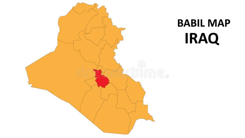
Free with trial Babil Map is highlighted on the Iraq map with detailed state and region outlines n. Highlighted iraq map vectors Babil Map is highlighted on the Iraq map with detailed state and region outlines
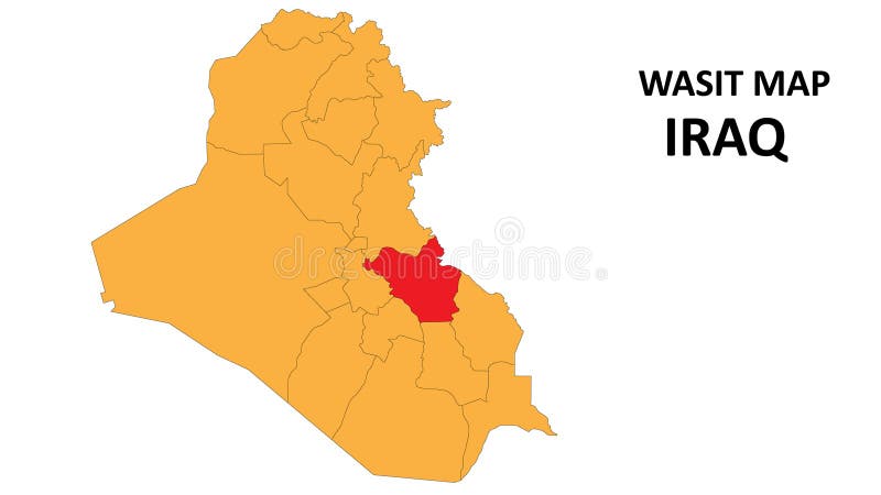
Free with trial Wasit Map is highlighted on the Iraq map with detailed state and region outlines n. Highlighted iraq map vectors Wasit Map is highlighted on the Iraq map with detailed state and region outlines
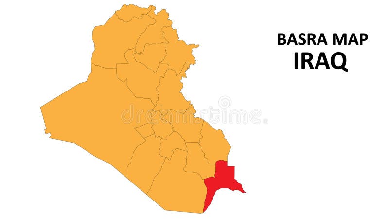
Free with trial Basra Map is highlighted on the Iraq map with detailed state and region outlines n. Highlighted iraq map vectors Basra Map is highlighted on the Iraq map with detailed state and region outlines
Free with trial Najaf Map is highlighted on the Iraq map with detailed state and region outlines n. Highlighted iraq map vectors Najaf Map is highlighted on the Iraq map with detailed state and region outlines
Free with trial Erbil Map is highlighted on the Iraq map with detailed state and region outlines n. Highlighted iraq map vectors Erbil Map is highlighted on the Iraq map with detailed state and region outlines
Free with trial Maysan Map is highlighted on the Iraq map with detailed state and region outlines n. Highlighted iraq map vectors Maysan Map is highlighted on the Iraq map with detailed state and region outlines
Free with trial Kirkuk Map is highlighted on the Iraq map with detailed state and region outlines n. Highlighted iraq map vectors Kirkuk Map is highlighted on the Iraq map with detailed state and region outlines
Free with trial Diyala Map is highlighted on the Iraq map with detailed state and region outlines n. Highlighted iraq map vectors Diyala Map is highlighted on the Iraq map with detailed state and region outlines
Free with trial Ninawa Map is highlighted on the Iraq map with detailed state and region outlines n. Highlighted iraq map vectors Ninawa Map is highlighted on the Iraq map with detailed state and region outlines
Free with trial Karbala Map is highlighted on the Iraq map with detailed state and region outlines n. Highlighted iraq map vectors Karbala Map is highlighted on the Iraq map with detailed state and region outlines
Free with trial Dhi Qar Map is highlighted on the Iraq map with detailed state and region outlines n. Highlighted iraq map vectors Dhi Qar Map is highlighted on the Iraq map with detailed state and region outlines
Free with trial Baghdad Map is highlighted on the Iraq map with detailed state and region outlines n. Highlighted iraq map vectors Baghdad Map is highlighted on the Iraq map with detailed state and region outlines
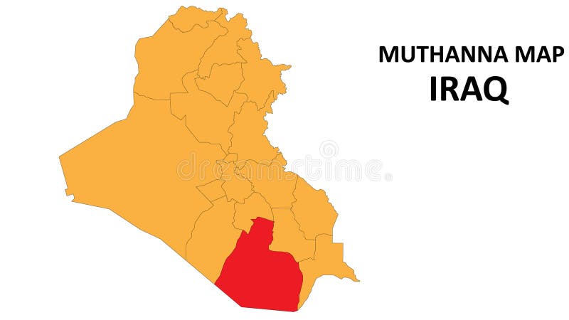
Free with trial Muthanna Map is highlighted on the Iraq map with detailed state and region outlines n. Highlighted iraq map vectors Muthanna Map is highlighted on the Iraq map with detailed state and region outlines
Free with trial Al-Anbar Map is highlighted on the Iraq map with detailed state and region outlines n. Highlighted iraq map vectors Al-Anbar Map is highlighted on the Iraq map with detailed state and region outlines
Free with trial SalahAl-Din Map is highlighted on the Iraq map with detailed state and region outlines n. Highlighted iraq map vectors SalahAl-Din Map is highlighted on the Iraq map with detailed state and region outlines
Free with trial Sulaymaniyah Map is highlighted on the Iraq map with detailed state and region outlines n. Highlighted iraq map vectors Sulaymaniyah Map is highlighted on the Iraq map with detailed state and region outlines
Free with trial Iraq highlighted on a detailed map, geographic location of Iraq. Vector Map. Highlighted iraq map vectors Iraq highlighted on a detailed map, geographic location of Iraq
Free with trial Iraq Highlighted on World Map with National Flag. Vector world map with Iraq highlighted using its national flag. Highlighted iraq map vectors Iraq Highlighted on World Map with National Flag. Iraq Map and Flag. Iraq Highlighted on World Map with National Flag. Vector world map with Iraq highlighted using its national flag
Free with trial Iraq Location Highlighted on Asian Map with Flag Icon. Detailed Vector Design. Highlighted iraq map vectors Iraq Location Highlighted on Asian Map with Flag Icon
Free with trial Highlighted Iraq on Global Map with 3D Flag Location Pin of Iraq. The image symbolizes travel, geography, international identity, and global navigation. Highlighted iraq map vectors Highlighted Iraq on Global Map with 3D Flag Location Pin of Iraq
Free with trial Iraq highlighted on a Pale colored elevation map with lakes and rivers. Highlighted iraq map illustrations Iraq highlighted. Pale. Iraq highlighted on a Pale colored elevation map with lakes and rivers
Free with trial Iraq highlighted on a Grayscale elevation map with lakes and rivers. Highlighted iraq map illustrations Iraq highlighted. Grayscale. Iraq highlighted on a Grayscale elevation map with lakes and rivers
Free with trial Iraq highlighted on a topographic, OSM standard style map map with the country's capital point, cartographic grid, distance scale and map border coordinates. Highlighted iraq map illustrations Iraq highlighted - composition. Topo standard. Iraq highlighted on a topographic, OSM standard style map map with the country's capital point, cartographic grid, distance scale and map border coordinates
Free with trial Iraq highlighted on a topographic, OSM Humanitarian style map. Highlighted iraq map illustrations Iraq highlighted. Topo Humanitarian. Iraq highlighted on a topographic, OSM Humanitarian style map
Free with trial Iraq highlighted on a high resolution satellite map. Highlighted iraq map illustrations Iraq highlighted. High-res satellite. Iraq highlighted on a high resolution satellite map
Free with trial Red simple blank political map of IRAQ with black national country borders on gray continent background and blue sea surfaces using orthographic projection of the highlighted beige Middle East. Highlighted iraq map vectors Red map of IRAQ inside highlighted beige map of the Middle East. Red simple blank political map of IRAQ with black national country borders on gray continent background and blue sea surfaces using orthographic projection of the highlighted beige Middle East
Free with trial Red simple blank political map of IRAQ with black national country borders on gray continent background and blue sea surfaces using orthographic projection of the highlighted beige Middle East. Highlighted iraq map vectors Red map of IRAQ inside highlighted beige map of the Middle East. Red simple blank political map of IRAQ with black national country borders on gray continent background and blue sea surfaces using orthographic projection of the highlighted beige Middle East
Free with trial Highlighted map of IRAQ inside detailed blank flat political map of the Asian continent on isolated background. Highlighted iraq map vectors Highlighted map of IRAQ inside political map of the Asian continent. Highlighted map of IRAQ inside detailed blank flat political map of the Asian continent on isolated background
Free with trial Highlighted map of IRAQ inside detailed blank flat political map of the Asian continent on isolated background. Highlighted iraq map vectors Highlighted map of IRAQ inside political map of the Asian continent. Highlighted map of IRAQ inside detailed blank flat political map of the Asian continent on isolated background
Free with trial Highlighted map of IRAQ inside detailed blank flat political map of the Asian continent on isolated background. Highlighted iraq map vectors Highlighted map of IRAQ inside political map of the Asian continent. Highlighted map of IRAQ inside detailed blank flat political map of the Asian continent on isolated background
Free with trial Highlighted map of IRAQ inside detailed blank flat political map of the Asian continent on isolated background. Highlighted iraq map vectors Highlighted map of IRAQ inside political map of the Asian continent. Highlighted map of IRAQ inside detailed blank flat political map of the Asian continent on isolated background
Free with trial Highlighted map of IRAQ inside detailed blank flat political map of the Asian continent on isolated background. Highlighted iraq map vectors Highlighted map of IRAQ inside political map of the Asian continent. Highlighted map of IRAQ inside detailed blank flat political map of the Asian continent on isolated background
Free with trial Highlighted map of IRAQ inside detailed blank flat political map of the Asian continent on isolated background. Highlighted iraq map vectors Highlighted map of IRAQ inside political map of the Asian continent. Highlighted map of IRAQ inside detailed blank flat political map of the Asian continent on isolated background
Free with trial Iraq Highlighted in Flag Colors on Geographic Map. Modern Map on a dark abstract backdrop. Highlighted iraq map vectors Iraq Highlighted in Flag Colors on Geographic Map
Free with trial Iraq Map Highlighted with Flag Marker. Flag Pointer on Geographic Map. Highlighted iraq map vectors Iraq Map Highlighted with Flag Marker
Free with trial Iran Highlighted in Red on Political Map of the Middle East illustration. Highlighted iraq map illustrations Iran Highlighted in Red on Political Map of the Middle East
Free with trial A stylized, glowing map of Iraq, divided into regions, with pins indicating specific locations. Includes a compass rose, suggesting navigation and global connectivity. Perfect for travel and geopoliti. Highlighted iraq map illustrations Map of iraq with highlighted regions and glowing pins. A stylized, glowing map of Iraq, divided into regions, with pins indicating specific locations. Includes a compass rose, suggesting navigation and global connectivity. Perfect for travel and geopoliti
Free with trial This image features a detailed map of the Middle East with specific countries highlighted in distinct colors. The map includes Turkey, Syria, Iraq, Iran, Saudi Arabia, Kuwait, Bahrain, United Arab Emirates, and Yemen. The highlighted countries are set against a transparent background, making the map visually clear and SEO-friendly. Highlighted iraq map illustrations Highlighted middle east map, isolated on white background. This image features a detailed map of the Middle East with specific countries highlighted in distinct colors. The map includes Turkey, Syria, Iraq, Iran, Saudi Arabia, Kuwait, Bahrain, United Arab Emirates, and Yemen. The highlighted countries are set against a transparent background, making the map visually clear and SEO-friendly
Free with trial High-resolution political map of the Middle East with Iran prominently highlighted in red. Ideal for educational materials, news articles, travel guides, and business presentations. Highlighted iraq map illustrations Detailed map of Iran highlighted in red on Middle East political geography. High-resolution political map of the Middle East with Iran prominently highlighted in red. Ideal for educational materials, news articles, travel guides, and business presentations
Free with trial This image depicts a world map with a focus on the Middle East and parts of Europe and Asia. The highlighted regions in red and green indicate specific areas of interest, possibly for geographical, political, or climatic analysis. The red area covers parts of the Middle East, including countries such as Turkey, Syria, Iraq, Iran, and parts of the Arabian Peninsula, while the green area spans. Highlighted iraq map illustrations Geographical map highlighting the middle east and surrounding regions in red and green. This image depicts a world map with a focus on the Middle East and parts of Europe and Asia. The highlighted regions in red and green indicate specific areas of interest, possibly for geographical, political, or climatic analysis. The red area covers parts of the Middle East, including countries such as Turkey, Syria, Iraq, Iran, and parts of the Arabian Peninsula, while the green area spans
Free with trial Map of the earth globe showing the location of the city Erbil in Iraq (Western Asia). The city in the map center is marked with a red dot and the country is also highlighted. No labels at all. Highlighted iraq map illustrations Map showing the location of the city Erbil in Iraq (Western Asia) on the earth globe. Map of the earth globe showing the location of the city Erbil in Iraq (Western Asia). The city in the map center is marked with a red dot and the country is also highlighted. No labels at all.
Free with trial Map of the earth globe showing the location of the city Mosul in Iraq (Western Asia). The city in the map center is marked with a red dot and the country is also highlighted. No labels at all. Highlighted iraq map illustrations Map showing the location of the city Mosul in Iraq (Western Asia) on the earth globe. Map of the earth globe showing the location of the city Mosul in Iraq (Western Asia). The city in the map center is marked with a red dot and the country is also highlighted. No labels at all.
Free with trial Map of the earth globe showing the location of the city Basrah in Iraq (Western Asia). The city in the map center is marked with a red dot and the country is also highlighted. No labels at all. Highlighted iraq map illustrations Map showing the location of the city Basrah in Iraq (Western Asia) on the earth globe. Map of the earth globe showing the location of the city Basrah in Iraq (Western Asia). The city in the map center is marked with a red dot and the country is also highlighted. No labels at all.
Free with trial Map of the earth globe showing the location of the city Kirkuk in Iraq (Western Asia). The city in the map center is marked with a red dot and the country is also highlighted. No labels at all. Highlighted iraq map illustrations Map showing the location of the city Kirkuk in Iraq (Western Asia) on the earth globe. Map of the earth globe showing the location of the city Kirkuk in Iraq (Western Asia). The city in the map center is marked with a red dot and the country is also highlighted. No labels at all.
Free with trial Map of the earth globe showing the location of the city Karbala in Iraq (Western Asia). The city in the map center is marked with a red dot and the country is also highlighted. No labels at all. Highlighted iraq map illustrations Map showing the location of the city Karbala in Iraq (Western Asia) on the earth globe. Map of the earth globe showing the location of the city Karbala in Iraq (Western Asia). The city in the map center is marked with a red dot and the country is also highlighted. No labels at all.
Free with trial Map of the earth globe showing the location of the city Baghdad in Iraq (Western Asia). The city in the map center is marked with a red dot and the country is also highlighted. No labels at all. Highlighted iraq map illustrations Map showing the location of the city Baghdad in Iraq (Western Asia) on the earth globe. Map of the earth globe showing the location of the city Baghdad in Iraq (Western Asia). The city in the map center is marked with a red dot and the country is also highlighted. No labels at all.
Free with trial Light green detailed blank political map of IRAQ with black national country borders on gray continent background and white sea surfaces using orthographic projection of dark green Middle East. Highlighted iraq map vectors Light green map of IRAQ inside highlighted dark green map of the Middle East. Light green detailed blank political map of IRAQ with black national country borders on gray continent background and white sea surfaces using orthographic projection of dark green Middle East
Free with trial Iraq Map in Blue with Gold Framed Accents. Modern Vector Map of Iraq. Vector Illustration. Highlighted iraq map vectors Iraq Map in Blue with Gold Framed Accents. Modern Vector Map of Iraq
Free with trial Vector illustration map of Iraq. A country in southwest Asia. Highlighted iraq map vectors Vector illustration map of Iraq
Free with trial Iraq map pin flag icon. Iraqi pennant map marker on a metal needle. 3D realistic vector illustration. Highlighted iraq map vectors Iraq map pin flag. 3D realistic vector illustration. Iraq map pin flag icon. Iraqi pennant map marker on a metal needle. 3D realistic vector illustration
Free with trial Iraq map pin flag icon. Iraqi pennant map marker on a metal needle. 3D realistic vector illustration. Highlighted iraq map illustrations Iraq map pin flag. 3D realistic vector illustration. Iraq map pin flag icon. Iraqi pennant map marker on a metal needle. 3D realistic vector illustration
Free with trial Detailed highlighted map of the region of the middle earth, vector illustration. Highlighted iraq map vectors Middle earth map. Detailed highlighted map of the region of the middle earth, vector illustration
Free with trial A conceptual map of the Middle East with Iran highlighted in glowing red, overlaid with a rising financial line graph and candlestick chart representing soaring WTI crude oil prices. The graphic includes text labels citing supply disruptions and geopolitical tensions as drivers for a price spike reaching nearly $200 per barrel by late 2026. Surrounding countries like Saudi Arabia, Iraq, and Turkey. Highlighted iraq map illustrations Map of Iran with soaring oil price graph. Geopolitical tensions on Middle East and supply disruptions causing crude spike. A conceptual map of the Middle East with Iran highlighted in glowing red, overlaid with a rising financial line graph and candlestick chart representing soaring WTI crude oil prices. The graphic includes text labels citing supply disruptions and geopolitical tensions as drivers for a price spike reaching nearly $200 per barrel by late 2026. Surrounding countries like Saudi Arabia, Iraq, and Turkey
Free with trial Map of the Middle East with Iran highlighted in dark grey. The surrounding countries are displayed in white, and the seas are in blue. A location marker indicates the Strait of Hormuz, a critical chokepoint for global oil shipping. The map emphasizes Iran's geopolitical significance in the region. Highlighted iraq map illustrations Middle East Map with Iran Highlighted in Dark Grey and Strait of Hormuz Location Marker, Geopolitical Conflict and Oil Shipping. Map of the Middle East with Iran. Map of the Middle East with Iran highlighted in dark grey. The surrounding countries are displayed in white, and the seas are in blue. A location marker indicates the Strait of Hormuz, a critical chokepoint for global oil shipping. The map emphasizes Iran's geopolitical significance in the region.
Free with trial A map of the middle east with the strait of hormuz highlighted, showing the persian gulf and gulf of oman. Highlighted iraq map illustrations A map of the middle east showing the strait of hormuz. a map of the middle east with the strait of hormuz highlighted, showing the persian gulf and gulf of oman
Free with trial Detailed 3D rendered map showcasing the strategic Strait of Hormuz, key Middle Eastern countries, and major oil shipping routes. Ideal for geopolitical analysis, news reports, and educational content on global energy trade. Highlighted iraq map illustrations 3d map of strait of hormuz with middle east countries and oil routes highlighted. Detailed 3D rendered map showcasing the strategic Strait of Hormuz, key Middle Eastern countries, and major oil shipping routes. Ideal for geopolitical analysis, news reports, and educational content on global energy trade
Free with trial High-resolution vector-style political map of the Middle East showcasing countries, major cities, and key water bodies like the Red Sea and Persian Gulf. Ideal for educational, business, and travel-related projects. Highlighted iraq map illustrations Detailed political map of middle east with red sea and persian gulf highlighted. High-resolution vector-style political map of the Middle East showcasing countries, major cities, and key water bodies like the Red Sea and Persian Gulf. Ideal for educational, business, and travel-related projects
Free with trial This image is a map focusing on the Arabian Peninsula, specifically highlighting Saudi Arabia in red and its neighboring regions in green. The map includes surrounding countries like Iraq, Bahrain, Qatar, United Arab Emirates, Oman, Yemen, and Kuwait. The map is useful for visualizing the geographical and political layout of this significant Middle Eastern area, showing borders and country names. Highlighted iraq map illustrations Geographical and political map highlighting saudi arabia and neighboring regions in the arabian peninsula. This image is a map focusing on the Arabian Peninsula, specifically highlighting Saudi Arabia in red and its neighboring regions in green. The map includes surrounding countries like Iraq, Bahrain, Qatar, United Arab Emirates, Oman, Yemen, and Kuwait. The map is useful for visualizing the geographical and political layout of this significant Middle Eastern area, showing borders and country names
Free with trial Red simple blank political map of OMAN with black borders on gray continent background and blue sea surfaces using orthographic projection of the highlighted beige Middle East. Highlighted iraq map vectors Red map of OMAN inside highlighted beige map of the Middle East. Red simple blank political map of OMAN with black borders on gray continent background and blue sea surfaces using orthographic projection of the highlighted beige Middle East