Free with trial Highly detailed physical map of the world,in vector format,with all the relief forms,countries and big cities. Indian cities vectors Physical map of the world
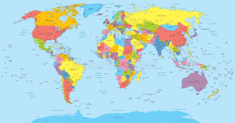
Free with trial Vector illustration of a High Detail Political Map of the world with different colors for each country. Each country has its capital and major cities. All seas and major lakes are named. Global colors used. All elements are separated in editable layers. Indian cities vectors World map with countries, country and city names. Vector illustration of a High Detail Political Map of the world with different colors for each country. Each country has its capital and major cities. All seas and major lakes are named. Global colors used. All elements are separated in editable layers.
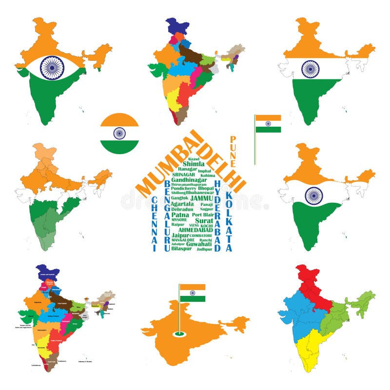
Free with trial India map designed in illustration with the regions colored in bright colors and with the main cities. On an illustration neighbouring countries are shown too. Indian cities vectors Map of India. India map designed in illustration with the regions colored in bright colors and with the main cities. On an illustration neighbouring countries are shown too
Free with trial Set of Indian cities skylines Mumbai Delhi Jaipur Kolkata Hyderabad Ahmedabad Pune Chennai Bangalore Trendy vector illustration linear style. Indian cities vectors Set Indian skylines Mumbai Delhi Jaipur Kolkata. Set of Indian cities skylines Mumbai Delhi Jaipur Kolkata Hyderabad Ahmedabad Pune Chennai Bangalore Trendy vector illustration linear style
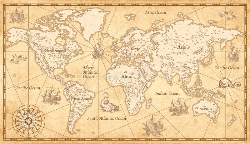
Free with trial Great Detail Illustration of the world map in vintage style with mountains, trees, cities and main rivers on a old parchment background. Indian cities vectors Vintage Illustrated World Map. Great Detail Illustration of the world map in vintage style with mountains, trees, cities and main rivers on a old parchment background.
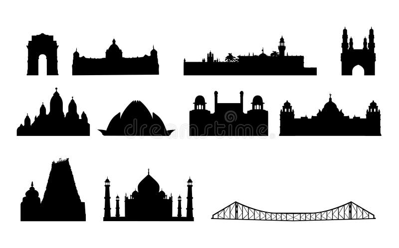
Free with trial Vectored illustrations as silhouettes of most famous landmarks and buildings in india, as india gate, calcutta iron bridge, and lotus, and other from cities as bombay, delhi, hyderabad and chennai. Indian cities vectors India famous landmarks vector. Vectored illustrations as silhouettes of most famous landmarks and buildings in india, as india gate, calcutta iron bridge, and lotus, and other from cities as bombay, delhi, hyderabad and chennai
Free with trial Vectored illustrations as silhouettes of most famous landmarks and buildings in india, as india gate, calcutta iron bridge, and lotus, and other from cities as bombay, delhi, hyderabad and chennai, all in a row, as cool travel background. Indian cities vectors India landmarks skyline vector. Vectored illustrations as silhouettes of most famous landmarks and buildings in india, as india gate, calcutta iron bridge, and lotus, and other from cities as bombay, delhi, hyderabad and chennai, all in a row, as cool travel background
Free with trial World landmarks decorative icons set with eiffel tower big ben coliseum isolated vector illustration. Indian cities vectors World Landmarks Set. World landmarks decorative icons set with eiffel tower big ben coliseum isolated vector illustration
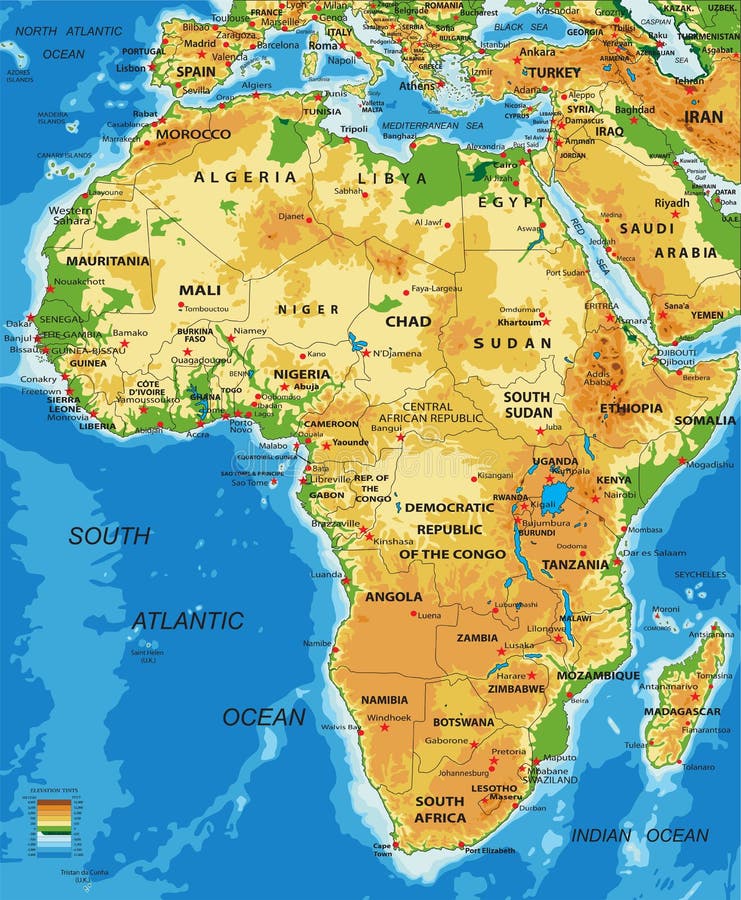
Free with trial Highly detailed physical map of Africa, in vector format, with all the relief forms, countries and big cities. Indian cities vectors Africa-physical map. Highly detailed physical map of Africa, in vector format, with all the relief forms, countries and big cities.
Free with trial India map designed in illustration with regions colored in bright colors and with the main cities. Neighbouring countries are in an additional format (. AI) in the latent layer. Indian cities vectors India map
Free with trial Set of Indian cities skylines Surat Visakhapatnam Thane Patna Nagpur Lucknow Indore Bhopal Kanpur Trendy vector illustration linear style. Indian cities vectors Set Indian cities vector illustration linear. Set of Indian cities skylines Surat Visakhapatnam Thane Patna Nagpur Lucknow Indore Bhopal Kanpur Trendy vector illustration linear style
Free with trial Australia road map with the most important cities and main roads. Indian cities vectors Australia map. Australia road map with the most important cities and main roads
Free with trial India map. Outline illustration country map with state names and their capital cities. Indian cities vectors India map
Free with trial World Landmark Icon Set. Travel symbol. Indian cities vectors Travel icons. World Landmark Icon Set. Travel symbol
Free with trial A set of world landmark icons. Indian cities vectors World Landmark Icon Set. A set of world landmark icons
Free with trial Highly detailed vector map of Ethiopia with administrative regions,main cities and roads. Indian cities vectors Ethiopia map. Highly detailed vector map of Ethiopia with administrative regions,main cities and roads.
Free with trial Political map of Tanzania with the capital Dodoma, national borders, most important cities, rivers and lakes. Vector illustration with english labeling and scale. Indian cities vectors Tanzania Political Map. Political map of Tanzania with the capital Dodoma, national borders, most important cities, rivers and lakes. Vector illustration with english labeling and scale.
Free with trial Highly detailed physical map of Africa, in vector format, with all the relief forms, countries and big cities. Indian cities vectors Africa-physical map. Highly detailed physical map of Africa, in vector format, with all the relief forms, countries and big cities.
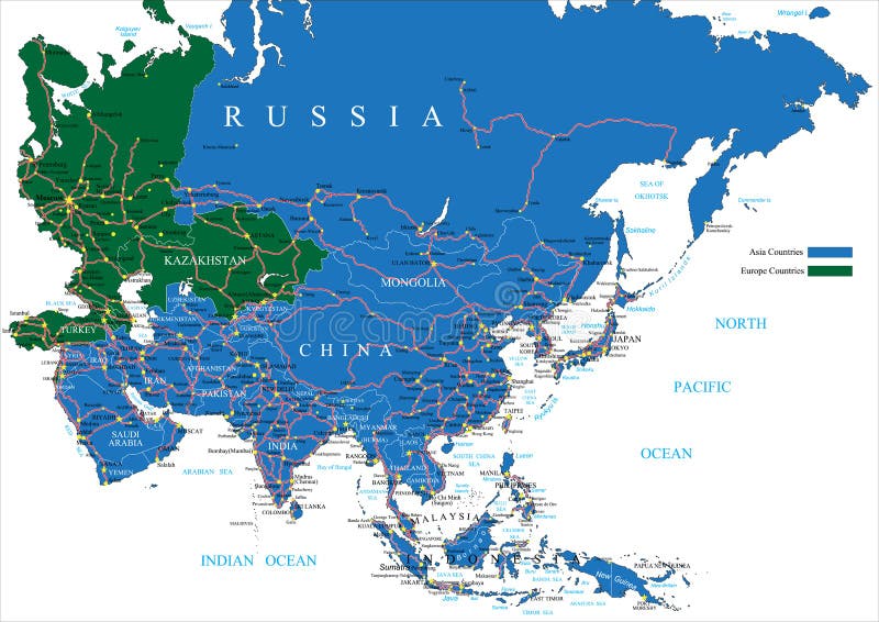
Free with trial Highly detailed vector map of Asia with countries, main cities and roads. Indian cities vectors Asia road map. Highly detailed vector map of Asia with countries, main cities and roads.
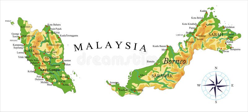
Free with trial Highly detailed physical map of Malaysia,in vector format,with all the relief forms,regions and big cities. Indian cities vectors Malaysia physical map. Highly detailed physical map of Malaysia,in vector format,with all the relief forms,regions and big cities.
Free with trial India map designed in illustration with regions colored in green colors and with the main cities. Neighbouring countries are in an additional format (. AI) in the latent layer. Indian cities vectors India
Free with trial Vectored illustrations as silhouettes of most famous landmarks and buildings in india, as india gate, calcutta iron bridge, and lotus, and other from cities as bombay, delhi, hyderabad and chennai and mandurai, all listed on a map with flag. Indian cities vectors India landmarks on map vector. Vectored illustrations as silhouettes of most famous landmarks and buildings in india, as india gate, calcutta iron bridge, and lotus, and other from cities as bombay, delhi, hyderabad and chennai and mandurai, all listed on a map with flag
Free with trial Traditional symbols in the form of a USA map. Indian cities illustrations Map of USA. Traditional symbols in the form of a USA map
Free with trial Map of Canada and Travel Icons. Canada Travel Map. Vector Illustration. Indian cities vectors Canada Travel Collection. Map of Canada and Travel Icons. Canada Travel Map. Vector Illustration
Free with trial Traditional symbols of architecture and culture of the USA in the form of heart. Indian cities vectors Icons of the USA in the form of heart. Traditional symbols of architecture and culture of the USA in the form of heart
Free with trial Vector Set of Various Canada Icons on a Circle Shape. Indian cities vectors Canada Travel Collection. Vector Set of Various Canada Icons on a Circle Shape.
Free with trial India map with indian flag. Indian cities displayed as house. Indian states and union territories map. tri color and ashoka chakra. Indian cities vectors India map, indian cities, states and india flag. India map with indian flag. Indian cities displayed as house. Indian states and union territories map. tri color and ashoka chakra.
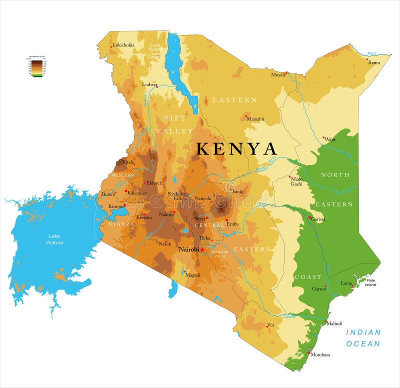
Free with trial Highly detailed physical map of the Kenya,in vector format,with all the relief forms,regions and big cities. Indian cities vectors Kenya physical map. Highly detailed physical map of the Kenya,in vector format,with all the relief forms,regions and big cities
Free with trial Map of India. Outline illustration country map with major cities (state capitals). Indian cities vectors India
Free with trial Great Detail Illustration of the world map in vintage style with mountains, trees, cities and main rivers on a old parchment background. Indian cities vectors Vintage Illustrated World Map. Great Detail Illustration of the world map in vintage style with mountains, trees, cities and main rivers on a old parchment background.
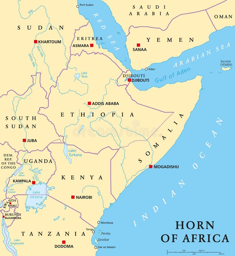
Free with trial Horn of Africa peninsula political map with capitals, national borders, important cities, rivers and lakes. In ancient times called Land of the Berbers. English labeling and scaling. Illustration. Indian cities vectors Horn of Africa Political Map. Horn of Africa peninsula political map with capitals, national borders, important cities, rivers and lakes. In ancient times called Land of the Berbers. English labeling and scaling. Illustration.
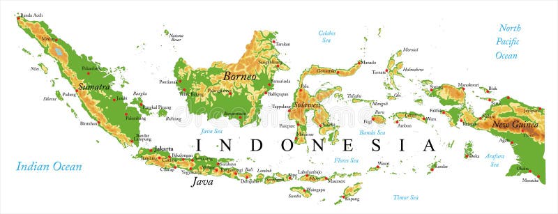
Free with trial Highly detailed physical map of Indonesia,in vector format,with all the relief forms,regions and big cities. Indian cities vectors Indonesia Relief map. Highly detailed physical map of Indonesia,in vector format,with all the relief forms,regions and big cities.
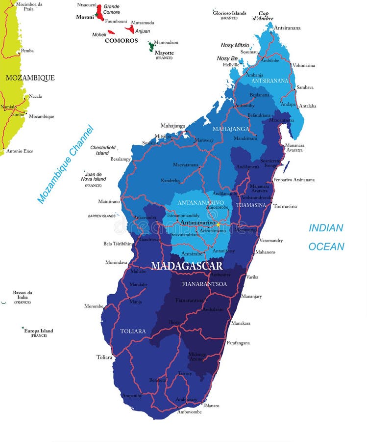
Free with trial Highly detailed vector map of Madagascar with administrative regions,main cities and roads. Indian cities vectors Madagascar map. Highly detailed vector map of Madagascar with administrative regions,main cities and roads.
Free with trial Political map of Ethiopia with capital Addis Ababa, national borders, most important cities, rivers and lakes. Illustration with English labeling and scaling. Indian cities vectors Ethiopia Political Map. Political map of Ethiopia with capital Addis Ababa, national borders, most important cities, rivers and lakes. Illustration with English labeling and scaling.
Free with trial Highly detailed Earth, illuminated by moonlight. The glow of cities sheds light on the detailed exaggerated terrain and translucent water of the oceans. Elements of this image furnished by NASA. Indian cities illustrations Night Earth. Part of Australia. Tasmania. Highly detailed Earth, illuminated by moonlight. The glow of cities sheds light on the detailed exaggerated terrain and translucent water of the oceans. Elements of this image furnished by NASA
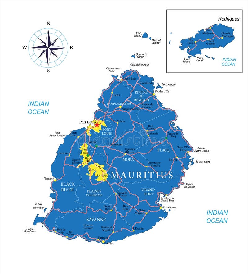
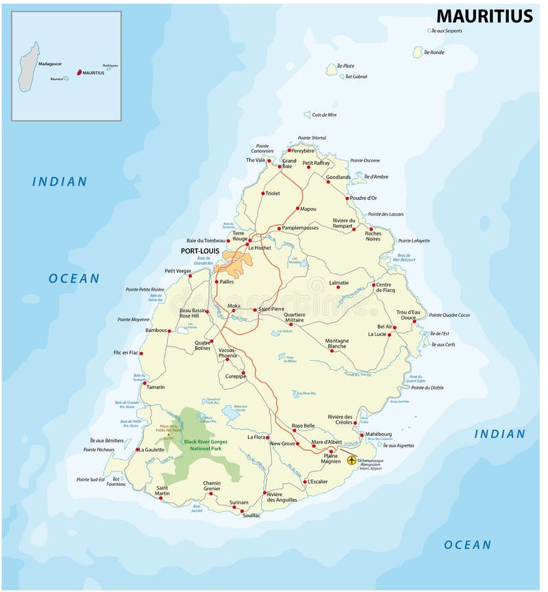
Free with trial Highly detailed vector map of Mauritius with administrative regions, main cities and roads. Indian cities vectors Mauritius map. Highly detailed vector map of Mauritius with administrative regions, main cities and roads.
Free with trial Highly detailed Earth, illuminated by moonlight. The glow of cities sheds light on the detailed exaggerated terrain. Night Earth. India and Sri Lanka. Elements of this image furnished by NASA. Indian cities illustrations Night Earth. India and Sri Lanka
Free with trial Australia Political Map with capital Canberra, national borders, important cities, rivers and lakes. English labeling and scaling. Illustration. Indian cities vectors Australia Political Map
Free with trial World famous monuments icon set. Indian cities illustrations World famous monuments background. World famous monuments icon set.
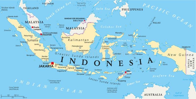
Free with trial Indonesia political map with capital Jakarta, national borders and important cities. English labeling and scaling. Illustration. Indian cities vectors Indonesia Political Map
Free with trial Seychelles Political Map with capital Victoria, important cities and islands and an overview map of the whole archipelago. English labeling and scaling. Illustration. Indian cities vectors Seychelles Political Map
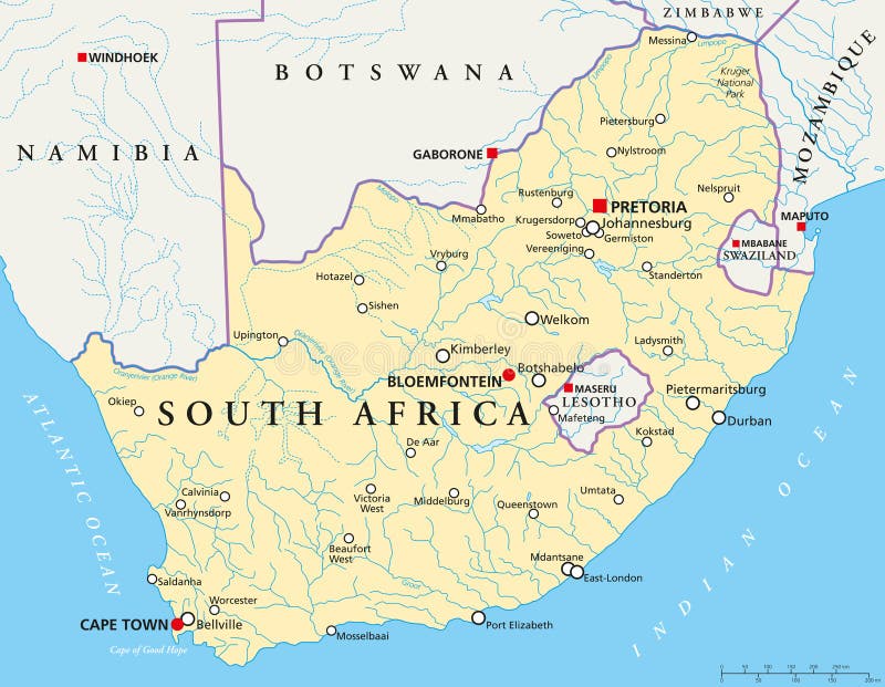
Free with trial Political map of South Africa with the capitals Pretoria, Bloemfontein and Cape Town, with national borders, most important cities, rivers and lakes. Illustration with English labeling and scaling. Indian cities vectors South Africa Political Map. Political map of South Africa with the capitals Pretoria, Bloemfontein and Cape Town, with national borders, most important cities, rivers and lakes. Illustration with English labeling and scaling.
Free with trial Vector map of the great African lakes. Indian cities vectors Map of the great African lakes
Free with trial Mombasa Nairobi Railway map in kenya. Indian cities vectors Mombasa Nairobi Railway map in kenya
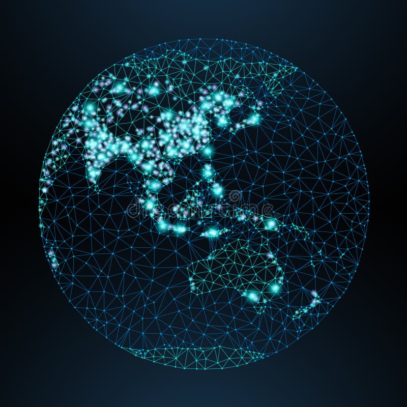
Free with trial Vector low-poly image of a globe with lights in the form of world cities or population density, consisting points, lines and shapes in form of stars and space. View of Asia. Indian cities vectors Vector low-poly image of a globe with lights
Free with trial Map of USA vector illustration, design. Icons with American white house, grand canyon, statue of liberty. New York and Washington cities. Explore United States of America concept image. Indian cities vectors Map of USA vector illustration, design
Free with trial Map of America vector illustration, design. Icons with USA capitol, statue of liberty, golden gate bridge. New York and san Francisco cities. Explore United states of America concept image. Indian cities vectors Map of America vector illustration, design
Free with trial Traditional symbols of architecture and culture of the USA. Indian cities vectors Symbols of the USA. Traditional symbols of architecture and culture of the USA
Free with trial Stylized map of the United States with American symbols. Indian cities vectors Stylized map of USA with traditional symbols. Stylized map of the United States with American symbols
Free with trial Cartoon vector map of India. Travel illustration with indian main cities. Vector illustration. Indian cities vectors Cartoon vector map of India. Travel illustration with indian main cities.
Free with trial Set of Indian cities skylines Surat Visakhapatnam Thane Patna Nagpur Lucknow Indore Bhopal Kanpur Trendy vector illustration linear style. Indian cities vectors Set Indian cities vector illustration linear. Set of Indian cities skylines Surat Visakhapatnam Thane Patna Nagpur Lucknow Indore Bhopal Kanpur Trendy vector illustration linear style
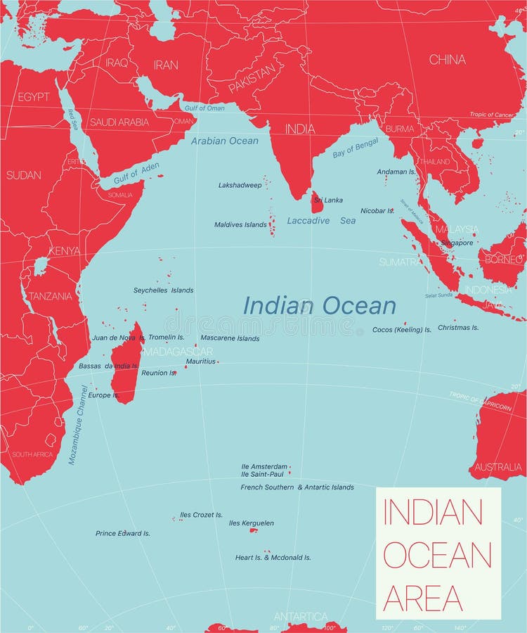
Free with trial Indian ocean region detailed editable map with regions cities and towns, geographic sites. Vector EPS-10 file. Indian cities vectors Indian ocean region detailed editable map
Free with trial India map. Cities regions Vector illustration. Indian cities illustrations India map. Cities, regions. Vector. India map. Cities regions Vector illustration
Free with trial List of cities and towns in India composed in love sign heart shape, word cloud collage, business and travel concept background. Indian cities illustrations List of cities and towns in India
Free with trial Large and detailed map of Indian River county in Florida, USA. Indian cities vectors Map of Indian River County in Florida
Free with trial Detailed vector map of Mauritius with main cities and roads. Indian cities illustrations Mauritius road map. Detailed vector map of Mauritius with main cities and roads
Free with trial Highly detailed physical map of Comoros islands in vector format,with all the relief forms,regions and big cities. Indian cities vectors Comoros islands highly detailed physical map. Highly detailed physical map of Comoros islands in vector format,with all the relief forms,regions and big cities
Free with trial South Africa,gray political map with nine provinces,with largest cities,and borders. Republic and southernmost country in Africa,with the three capitals Pretoria,Cape Town and Bloemfontein. Indian cities vectors South Africa, gray political map with provinces and largest cities. South Africa,gray political map with nine provinces,with largest cities,and borders. Republic and southernmost country in Africa,with the three capitals Pretoria,Cape Town and Bloemfontein.
Free with trial Highly detailed physical map of Seychelles islands in vector format,with all the relief forms,regions and big cities. Indian cities vectors Seychelles islands highly detailed physical map. Highly detailed physical map of Seychelles islands in vector format,with all the relief forms,regions and big cities
Free with trial South Africa,political map with provinces,largest cities,international and administrative borders. Republic and southernmost country in Africa,with capitals Pretoria,Cape Town and Bloemfontein. Indian cities vectors South Africa, political map with provinces, largest cities and borders. South Africa,political map with provinces,largest cities,international and administrative borders. Republic and southernmost country in Africa,with capitals Pretoria,Cape Town and Bloemfontein.
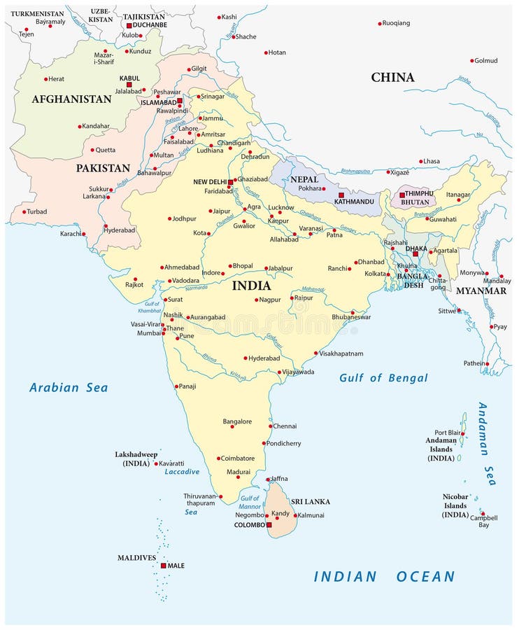
Free with trial Detailed vector map of south asia with the biggest cities. Indian cities illustrations South asia map. Detailed vector map of south asia with the biggest cities
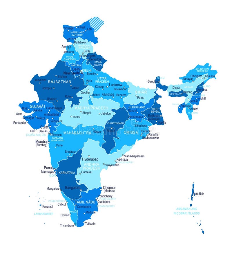
Free with trial India map with the main cities. Indian cities vectors India map with the main cities.
Free with trial Highly detailed physical map of Maldives islands in vector format,with all the relief forms,regions and big cities. Indian cities vectors Maldives islands highly detailed physical map. Highly detailed physical map of Maldives islands in vector format,with all the relief forms,regions and big cities
Free with trial The detailed map of the India with regions or states and cities, capitals and Sri Lanka. Indian cities vectors The detailed map of the India with regions or states and cities, capitals and Sri Lanka
Free with trial The detailed map of the India with regions or states and cities, capital. Administrative division. Indian cities vectors The detailed map of the India with regions or states and cities, capital. Administrative division.
Free with trial South Africa,flag and major cities. Indian cities vectors South Africa map. South Africa,flag and major cities.
Free with trial Popular cities in India. India map in 2020 with colouring state. Vector illustration of State and city map of India country. Indian cities vectors Popular cities in India.India map in 2020 with colouring state.Vector illustration of State and city map of India
Free with trial Highly detailed Earth, illuminated by moonlight. The glow of cities sheds light on the detailed exaggerated terrain. Night Earth. Africa and Madagascar. Elements of this image furnished by NASA. Indian cities illustrations Night Earth. Africa and Madagascar
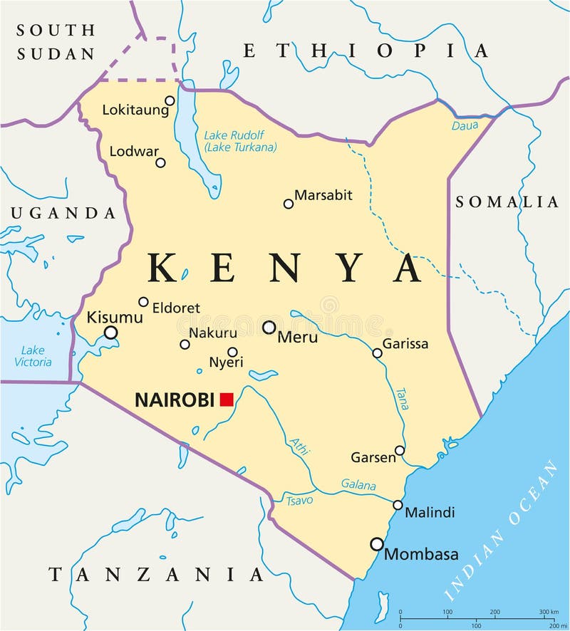
Free with trial Political map of Kenya with capital Nairobi, national borders, most important cities, rivers and lakes. Illustration with English labeling and scaling. Indian cities vectors Kenya Political Map. Political map of Kenya with capital Nairobi, national borders, most important cities, rivers and lakes. Illustration with English labeling and scaling.
Free with trial World famous monuments icon set. Indian cities illustrations World famous monuments background. World famous monuments icon set.
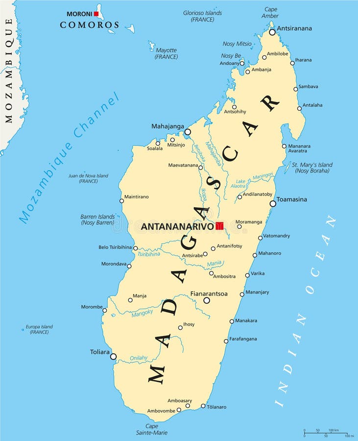
Free with trial Madagascar Political Map with capital Antananarivo, national borders, important cities, rivers and lakes. English labeling and scaling. Illustration. Indian cities vectors Madagascar Political Map
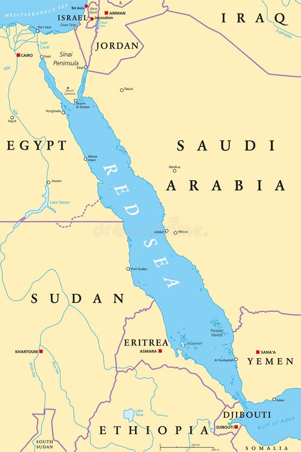
Free with trial Red Sea region political map with capitals, borders, important cities, rivers and lakes. Erythraean Sea, seawater inlet of Indian Ocean between Africa and Asia. Illustration. English labeling. Vector. Indian cities vectors Red Sea region political map
Free with trial TEMPLES OF INDIA FAMOUS TEMPLES ON INDIA MAP WITH LOCATIONS HINDUSTHAN. Indian cities illustrations TEMPLES OF INDIA FAMOUS TEMPLES ON INDIA MAP WITH LOCATIONS
Free with trial Vector map of Central America with Countries, Capitals, Main Cities and Seas and islands names in classic soft colors palette. Indian cities vectors Colorful Vector map of Central America. Vector map of Central America with Countries, Capitals, Main Cities and Seas and islands names in classic soft colors palette.
Free with trial Vector map of Central America with Countries, Capitals, Main Cities and Seas and islands names in strong brilliant colors palette. Indian cities vectors Colorful Vector map of Central America. Vector map of Central America with Countries, Capitals, Main Cities and Seas and islands names in strong brilliant colors palette.
Free with trial Highly detailed Earth with atmosphere, exaggerated relief and light-flooded cities. Transition from night to day. Asia. Indochina peninsula. 3D rendering. Elements of this image furnished by NASA. Indian cities illustrations Detailed Earth. Asia. Indochina peninsula. Highly detailed Earth with atmosphere, exaggerated relief and light-flooded cities. Transition from night to day. Asia. Indochina peninsula. 3D rendering. Elements of this image furnished by NASA
Free with trial Indian urban architectural style color building panorama set. Indian cities illustrations Hindu urban architectural style. Indian urban architectural style color building panorama set
Free with trial Great Detail Illustration of the North America map in vintage style with mountains, trees, cities and main rivers on a old parchment background decorated with many original illustrations. Indian cities vectors Illustrated Vintage North America Map. Great Detail Illustration of the North America map in vintage style with mountains, trees, cities and main rivers on a old parchment background decorated with many original illustrations.
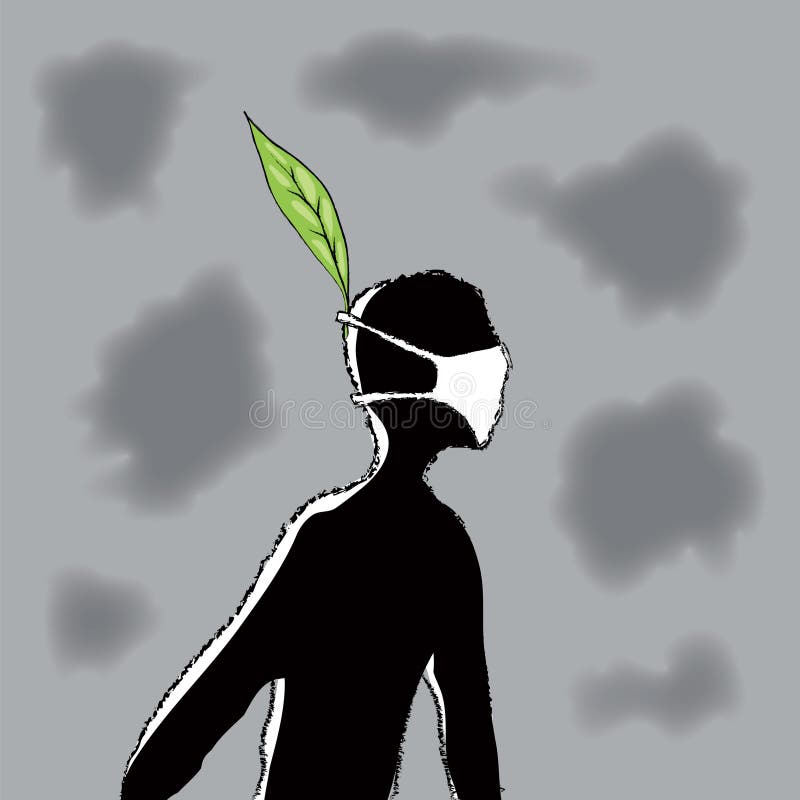
Free with trial Drawing freehand (cmyk to rgb). Indian cities vectors Air pollution (vector). Drawing freehand (cmyk to rgb)
Free with trial Sri Lanka political map with capitals Sri Jayawardenepura Kotte and Colombo, important cities, rivers and lakes. Former known as Ceylon, island country in South Asia. English labeling. Illustration. Indian cities vectors Sri Lanka Political Map