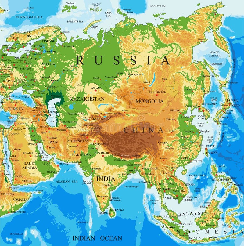
Free with trial Highly detailed physical map of Asia,in vector format,with all the relief forms. Laos physical map vectors Physical map of Asia
Free with trial High detail map of Asia continent, with a 3D Globe centered on Asia. n. Laos physical map vectors Asia Green Vector Map. High detail map of Asia continent, with a 3D Globe centered on Asia. n
Free with trial Highly detailed physical map of the Laos,in vector format,with all the relief forms,regions and big cities. Laos physical map vectors Laos physical map. Highly detailed physical map of the Laos,in vector format,with all the relief forms,regions and big cities
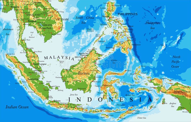
Free with trial Highly detailed physical map of Indonesia,in vector format,with all the relief forms,countries and big cities. Laos physical map vectors Indonesia physical map. Highly detailed physical map of Indonesia,in vector format,with all the relief forms,countries and big cities
Free with trial Physical map of the world, satellite view of Southeast Asia. Globe. Hemisphere. Reliefs and oceans. 3d rendering. Element of this image are furnished by NASA. Laos physical map illustrations Physical map of the world, satellite view of Southeast Asia, Indonesia. Globe. Hemisphere. Reliefs and oceans. Physical map of the world, satellite view of Southeast Asia. Globe. Hemisphere. Reliefs and oceans. 3d rendering. Element of this image are furnished by NASA
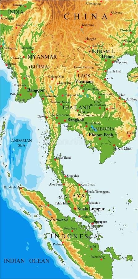
Free with trial Highly detailed physical map of Indochina,in vector format,with all the relief forms,countries and big cities. Laos physical map vectors Indochina physical map. Highly detailed physical map of Indochina,in vector format,with all the relief forms,countries and big cities.
Free with trial A very detailed map of the country of Syria colored with the most important rivers, lakes, seas in blue and forests in green, City, capital city. Laos physical map illustrations Physical map of the country of Syria colored. A very detailed map of the country of Syria colored with the most important rivers, lakes, seas in blue and forests in green, City, capital city
Free with trial Physical map centered on Laos neighborhood area. Laos physical map illustrations Globe centered on Laos neighborhood. Physical map. Physical map centered on Laos neighborhood area
Free with trial Physical globe map centered on Laos. Laos physical map illustrations Globe centered on Laos. Physical map. Physical globe map centered on Laos
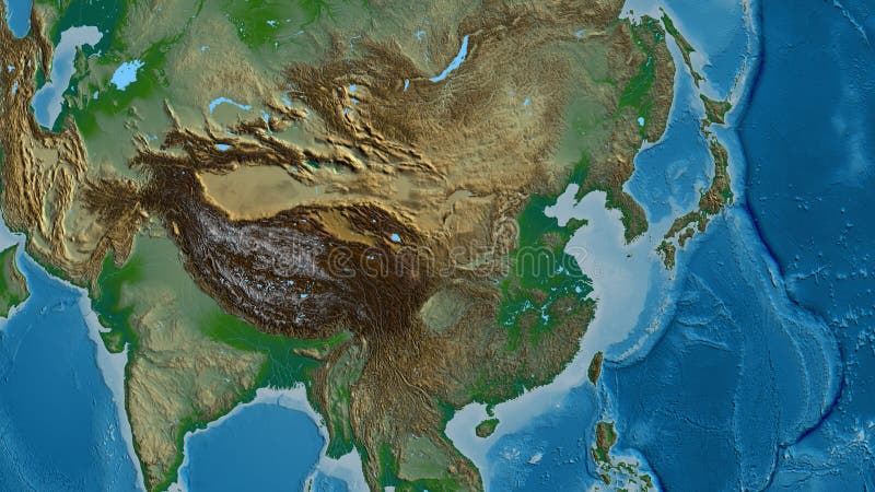
Free with trial A detailed physical relief map of the Indochinese Peninsula in Southeast Asia. This topographic map illustrates the region's diverse geography, with mountainous areas in shades of brown and yellow, and fertile lowlands in vibrant green. Key features like the Annamite Range and Mekong River basin are clearly visible. The map covers Thailand, Cambodia, Laos, and Vietnam, making it an excellent resource for educational, cartographic, geological, and travel-related projects, providing a clear visual representation of the area's physical landscape without any labels. Laos physical map illustrations Physical Map of the Indochinese Peninsula. A detailed physical relief map of the Indochinese Peninsula in Southeast Asia. This topographic map illustrates the region's diverse geography, with mountainous areas in shades of brown and yellow, and fertile lowlands in vibrant green. Key features like the Annamite Range and Mekong River basin are clearly visible. The map covers Thailand, Cambodia, Laos, and Vietnam, making it an excellent resource for educational, cartographic, geological, and travel-related projects, providing a clear visual representation of the area's physical landscape without any labels.
Free with trial This captivating silhouette map of Laos is perfect for educational purposes, showcasing the country's geographical features in a visually engaging way. The clean, black-and-chalkboard-style design creates a timeless aesthetic, ideal for classrooms, study rooms, or anyone interested in geography and exploring the diverse landscapes of Southeast Asia. The map clearly highlights the major physical. Laos physical map illustrations A Detailed Silhouette Map of Laos Educational Resource for Geography Studies in Asia. This captivating silhouette map of Laos is perfect for educational purposes, showcasing the country's geographical features in a visually engaging way. The clean, black-and-chalkboard-style design creates a timeless aesthetic, ideal for classrooms, study rooms, or anyone interested in geography and exploring the diverse landscapes of Southeast Asia. The map clearly highlights the major physical
Free with trial Laos region silhouettes set and blank map of the country isolated on white background. Vector illustration design. National region silhouettes Series. Laos physical map vectors Laos region silhouettes set and blank map of the country isolated on white background. Vector illustration design
Free with trial Abstract Laos Simple Map Background, vector editable design, can be used for business or presentation design. Laos physical map vectors Abstract Laos Simple Map Background
Free with trial Vector Laos Dotted Map Illustration, vector editable design, can be used for business or presentation design. Laos physical map vectors Vector Laos Dotted Map Illustration
Free with trial Abstract Silhouette Laos Simple Map, vector editable design, can be used for business or presentation design. Laos physical map vectors Abstract Silhouette Laos Simple Map
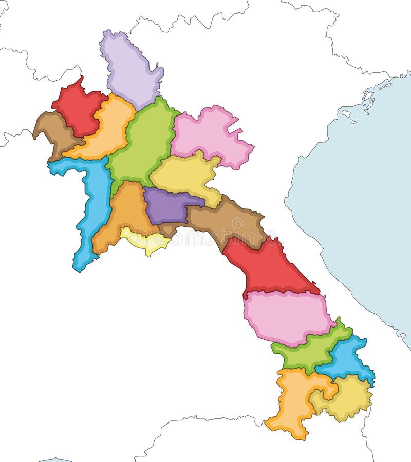
Free with trial Multicolor Map Of Laos With Provinces, vector editable design, can be used for business or presentation design. Laos physical map vectors Multicolor Map Of Laos With Provinces
Free with trial Colorful Laos Divided Map Illustration, vector editable design, can be used for business or presentation design. Laos physical map vectors Colorful Laos Divided Map Illustration
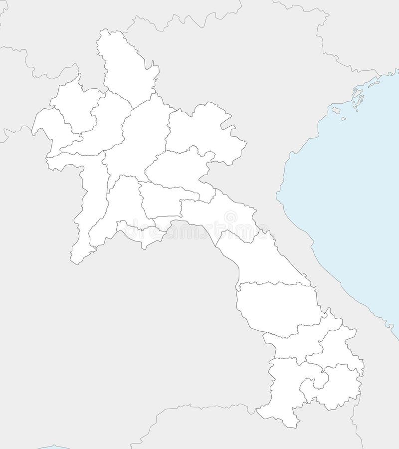
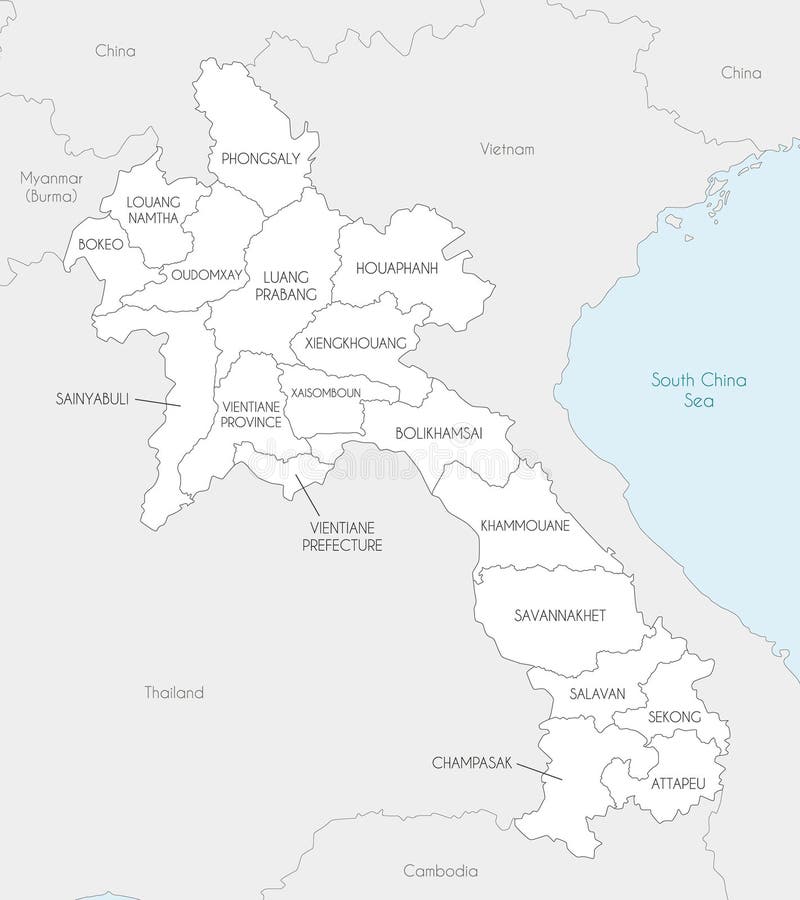
Free with trial Vector regional blank map of Laos with provinces and administrative divisions, and neighbouring countries and territories. Editable and clearly labeled layers. Laos physical map vectors Vector regional blank map of Laos with provinces and administrative divisions, and neighbouring countries and territories.
Free with trial Vector illustrated regional blank map of Laos with provinces and administrative divisions, and neighbouring countries and territories. Editable and clearly labeled layers. Laos physical map vectors Vector illustrated regional blank map of Laos with provinces and administrative divisions, and neighbouring countries. Vector illustrated regional blank map of Laos with provinces and administrative divisions, and neighbouring countries and territories. Editable and clearly labeled layers
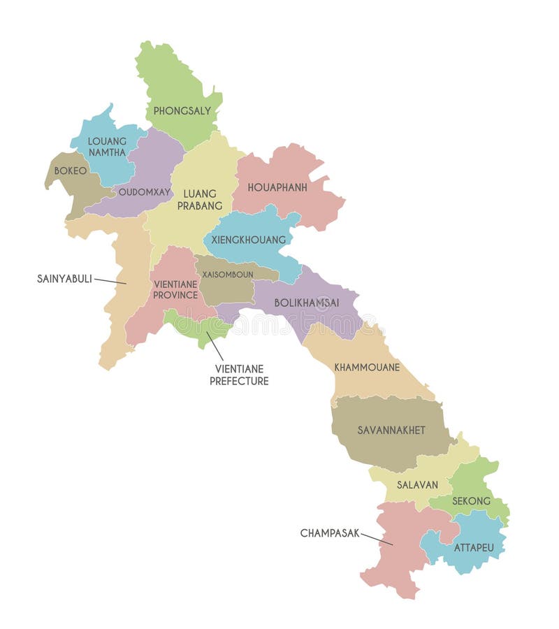
Free with trial Vector illustrated regional map of Laos with provinces and administrative divisions, and neighbouring countries and territories. Editable and clearly labeled layers. Laos physical map vectors Vector illustrated regional map of Laos with provinces and administrative divisions, and neighbouring countries and territories.
Free with trial Vector regional map of Laos with provinces and administrative divisions, and neighbouring countries and territories. Editable and clearly labeled layers. Laos physical map vectors Vector regional map of Laos with provinces and administrative divisions, and neighbouring countries and territories.
Free with trial Vector regional blank map of Laos with provinces or territories and administrative divisions. Editable and clearly labeled layers. Laos physical map vectors Vector regional blank map of Laos with provinces or territories and administrative divisions. Isolated on white background. Vector regional blank map of Laos with provinces or territories and administrative divisions. Editable and clearly labeled layers
Free with trial Grunge map of Laos printed on an old paper. Laos physical map illustrations Map of Laos printed on a paper. Grunge map of Laos printed on an old paper
Free with trial Vientiane capital city of Laos,Urban Streets Roads Map with city center location pin, illustration vector element image. Laos physical map vectors Vientiane, Laos,Urban Streets Roads Map with location pin. Vientiane capital city of Laos,Urban Streets Roads Map with city center location pin, illustration vector element image
Free with trial Outline Simple Map of Laos, can be used for business designs, presentation designs or any suitable designs. Laos physical map vectors Outline Simple Map of Laos
Free with trial Abstract Red Laos Simple Map, vector editable design, can be used for business or presentation design. Laos physical map vectors Abstract Red Laos Simple Map
Free with trial High Quality Yellow Laos Map, vector editable design, can be used for business or presentation design. Laos physical map vectors High Quality Yellow Laos Map
Free with trial Abstract Blue Laos Simple Map, vector editable design, can be used for business or presentation design. Laos physical map vectors Abstract Blue Laos Simple Map. Vector editable design, can be used for business or presentation design
Free with trial Black And White Laos Simple Map, vector editable design, can be used for business or presentation design. Laos physical map vectors Black And White Laos Simple Map
Free with trial Purple Editable Laos Simple Map, vector editable design, can be used for business or presentation design. Laos physical map vectors Purple Editable Laos Simple Map
Free with trial Green Vector Map Of Laos Country, vector editable design, can be used for business or presentation design. Laos physical map vectors Green Vector Map Of Laos Country
Free with trial Abstract Red Laos Map With Cities, vector editable design, can be used for business or presentation design. Laos physical map vectors Abstract Red Laos Map With Cities
Free with trial Vector Editable Pink Laos Simple Map, vector editable design, can be used for business or presentation design. Laos physical map vectors Vector Editable Pink Laos Simple Map
Free with trial Flat Gray Laos Map Banner Background, vector editable design, can be used for business or presentation design. Laos physical map vectors Flat Gray Laos Map Banner Background
Free with trial Abstract Laos Silhouette Detailed Map, vector editable design, can be used for business or presentation design. Laos physical map vectors Abstract Laos Silhouette Detailed Map
Free with trial Transparent Background Laos Simple Map, vector editable design, can be used for business or presentation design. Laos physical map vectors Transparent Background Laos Simple Map
Free with trial Black Outline Sketch Map Of Laos Country, vector editable design, can be used for business or presentation design. Laos physical map vectors Black Outline Sketch Map Of Laos Country
Free with trial Flat Gold Laos Simple Map Banner Background, vector editable design, can be used for business or presentation design. Laos physical map vectors Flat Gold Laos Simple Map Banner Background
Free with trial Detailed Map Of Laos With States And Cities, vector editable design, can be used for business or presentation design. Laos physical map vectors Detailed Map Of Laos With States And Cities
Free with trial Vector Brown Laos Map Isolated On White Background, vector editable design, can be used for business or presentation design. Laos physical map vectors Vector Brown Laos Map Isolated On White Background
Free with trial Blackboard with a the map of Laos drawn in the middle. Laos physical map illustrations Map of Laos drawn on a blackboard. Blackboard with a the map of Laos drawn in the middle
Free with trial A comprehensive and visually engaging map of Southeast Asia illustrates the region's political and physical geography through a color-coded design where different shades of green represent various countries and regions including Laos, Myanmar, Thailand, Cambodia, and Vietnam, while major hydrological features like the prominent Yangtze River flowing through the center alongside smaller rivers,. Laos physical map illustrations Detailed color-coded map of Southeast Asia showing countries, major cities, rivers, lakes, and geographical features with green. A comprehensive and visually engaging map of Southeast Asia illustrates the region's political and physical geography through a color-coded design where different shades of green represent various countries and regions including Laos, Myanmar, Thailand, Cambodia, and Vietnam, while major hydrological features like the prominent Yangtze River flowing through the center alongside smaller rivers,
Free with trial A detailed color-coded political map of Southeast Asia prominently features the countries of Laos, Myanmar, Cambodia, Thailand, and Vietnam using various shades of green and blue with accents of orange and yellow to differentiate regions, displaying national borders, labeled capital cities, and major urban centers alongside the intricate network of rivers and lakes that define the geography of. Laos physical map illustrations Color-coded political map of Southeast Asia showing Laos Myanmar Cambodia Thailand Vietnam with labeled capital cities rivers and. A detailed color-coded political map of Southeast Asia prominently features the countries of Laos, Myanmar, Cambodia, Thailand, and Vietnam using various shades of green and blue with accents of orange and yellow to differentiate regions, displaying national borders, labeled capital cities, and major urban centers alongside the intricate network of rivers and lakes that define the geography of
Free with trial Vector regional blank map of Laos with provinces or territories and administrative divisions. Editable and clearly labeled layers. Laos physical map vectors Vector regional blank map of Laos with provinces or territories and administrative divisions. Isolated on white background. Vector regional blank map of Laos with provinces or territories and administrative divisions. Editable and clearly labeled layers
Free with trial Vector regional map of Laos with provinces or territories and administrative divisions. Editable and clearly labeled layers. Laos physical map vectors Vector regional map of Laos with provinces or territories and administrative divisions. Isolated on white background. Vector regional map of Laos with provinces or territories and administrative divisions. Editable and clearly labeled layers
Free with trial Vector regional map of Laos with provinces or territories and administrative divisions. Editable and clearly labeled layers. Laos physical map vectors Vector regional map of Laos with provinces or territories and administrative divisions. Isolated on white background. Vector regional map of Laos with provinces or territories and administrative divisions. Editable and clearly labeled layers
Free with trial 3d Laos white map with regions isolated on white background. Laos physical map vectors 3d Laos white map with regions isolated
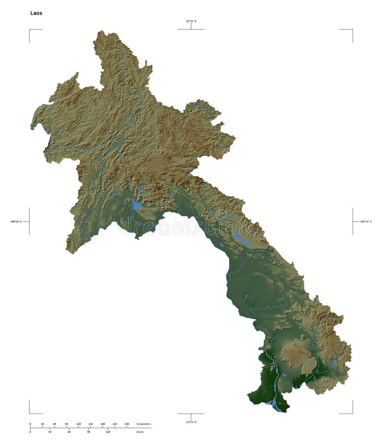
Free with trial Shape of a Colored elevation map with lakes and rivers of the Laos, with distance scale and map border coordinates, isolated on white. Laos physical map illustrations Laos shape on white. Physical. Shape of a Colored elevation map with lakes and rivers of the Laos, with distance scale and map border coordinates, isolated on white
Free with trial Physical map centered on China neighborhood area. Laos physical map illustrations Globe centered on China neighborhood. Physical map. Physical map centered on China neighborhood area
Free with trial Physical map centered on Myanmar neighborhood area. Laos physical map illustrations Globe centered on Myanmar neighborhood. Physical map. Physical map centered on Myanmar neighborhood area
Free with trial Physical map centered on Thailand neighborhood area. Laos physical map illustrations Globe centered on Thailand neighborhood. Physical map. Physical map centered on Thailand neighborhood area
Free with trial Physical globe map centered on Thailand. Laos physical map illustrations Globe centered on Thailand. Physical map. Physical globe map centered on Thailand
Free with trial Explore the intricate geography of Laos with this detailed line art map. Perfect for students, travelers, and designers, this vector graphic offers a clear representation of Laos borders, provinces, and major geographical features. The clean lines and illustrative style make it easy to visualize the country location in Southeast Asia. Ideal for educational purposes, planning journeys, or adding. Laos physical map illustrations Comprehensive Vector Map of Laos Detailed Line Art Geographic Illustration and Printable Options for Study Travel and. Explore the intricate geography of Laos with this detailed line art map. Perfect for students, travelers, and designers, this vector graphic offers a clear representation of Laos borders, provinces, and major geographical features. The clean lines and illustrative style make it easy to visualize the country location in Southeast Asia. Ideal for educational purposes, planning journeys, or adding
Free with trial Orange Simple Map Of Laos Country, vector editable design, can be used for business or presentation design. Laos physical map vectors Orange Simple Map Of Laos Country
Free with trial This captivating image showcases a detailed map of Laos, beautifully presented against a backdrop of the Lao national flag. The vibrant colors and intricate design of the flag create a striking contrast with the clear and precise map, making it ideal for a variety of uses. The map's clarity allows for easy identification of major cities, provinces, and geographical features, such as rivers and. Laos physical map illustrations Detailed Laos Map on a Vibrant National Flag Background A Stunning Geographic Stock Image Ideal for Educational. This captivating image showcases a detailed map of Laos, beautifully presented against a backdrop of the Lao national flag. The vibrant colors and intricate design of the flag create a striking contrast with the clear and precise map, making it ideal for a variety of uses. The map's clarity allows for easy identification of major cities, provinces, and geographical features, such as rivers and
Free with trial Grunge map of Laos with its flag printed within its border on an old paper. Laos physical map illustrations Map of Laos with its flag on a paper. Grunge map of Laos with its flag printed within its border on an old paper
Free with trial Close-up of aphysical map centered on China. Laos physical map illustrations China area. Physical map. Close-up of aphysical map centered on China
Free with trial Close-up of aphysical map centered on Myanmar. Laos physical map illustrations Myanmar area. Physical map. Close-up of aphysical map centered on Myanmar
Free with trial Close-up of aphysical map centered on Thailand. Laos physical map illustrations Thailand area. Physical map. Close-up of aphysical map centered on Thailand
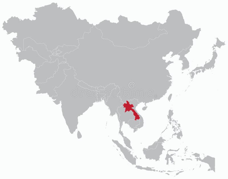
Free with trial Highlighted red map of LAOS inside grey detailed blank political map of Asia on light blue background, without the Middle East and Russia. Laos physical map vectors Highlighted red map of LAOS inside grey map of Asia with high details. Highlighted red map of LAOS inside grey detailed blank political map of Asia on light blue background, without the Middle East and Russia
Free with trial Highlighted red map of LAOS inside white detailed blank political map of Asia on blue background, without the Middle East and Russia. Laos physical map vectors Highlighted red map of LAOS inside white map of Asia with high details. Highlighted red map of LAOS inside white detailed blank political map of Asia on blue background, without the Middle East and Russia
Free with trial Highlighted red map of LAOS inside light red detailed political map of Asia using orthographic projection on white and blue background. Laos physical map vectors Highlighted red map of LAOS inside light red map of Asia with high details. Highlighted red map of LAOS inside light red detailed political map of Asia using orthographic projection on white and blue background
Free with trial Highlighted red map of LAOS inside orange detailed political map of Asia using orthographic projection on transparent background. Laos physical map vectors Highlighted red map of LAOS inside orange map of Asia with low details. Highlighted red map of LAOS inside orange detailed political map of Asia using orthographic projection on transparent background
Free with trial Highlighted red map of LAOS inside orange detailed tagged map of Asia using orthographic projection on blue background. Laos physical map vectors Highlighted red map of LAOS inside orange map of Asia with high details. Highlighted red map of LAOS inside orange detailed tagged map of Asia using orthographic projection on blue background
Free with trial Close-up of the China border area highlighting with a dark overlay on a physical map. Capital point. Glow around the country shape. English name of the country and its capital. Laos physical map illustrations China border shape overlay. Glowed. Physical. Labels. Close-up of the China border area highlighting with a dark overlay on a physical map. Capital point. Glow around the country shape. English name of the country and its capital
Free with trial Highlighted yellow map of LAOS inside white political map of Asia using orthographic projection on dark blue background. Laos physical map vectors Highlighted yellow map of LAOS inside white map of Asia with low details. Highlighted yellow map of LAOS inside white political map of Asia using orthographic projection on dark blue background
Free with trial Close-up of the China border area on a physical map. Capital point. Glow around the country shape. English name of the country and its capital. Laos physical map illustrations Shape of China. Glowed. Physical. Labels. Close-up of the China border area on a physical map. Capital point. Glow around the country shape. English name of the country and its capital
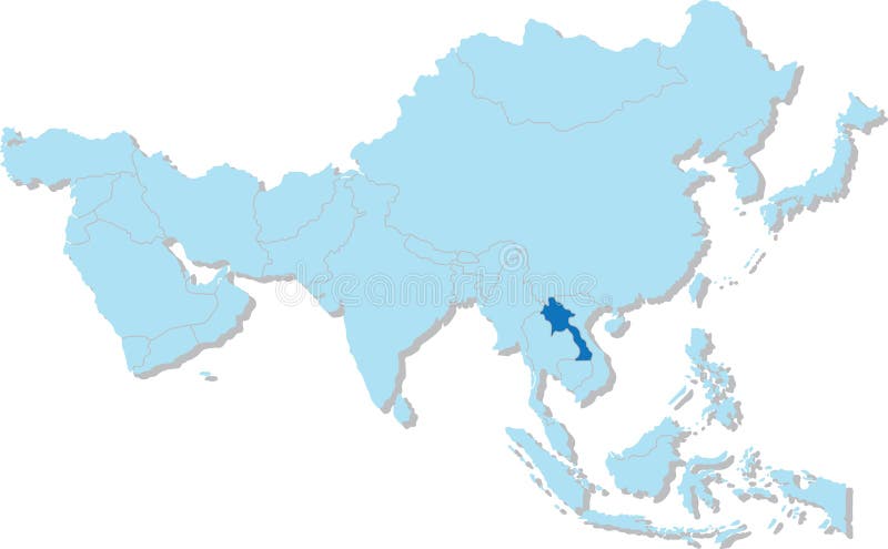
Free with trial Highlighted blue map of LAOS inside light blue 3D blank political map of Asia orthographic projection on transparent background, without Russia. Laos physical map vectors Highlighted blue map of LAOS inside light blue 3D map of Asia with low details. Highlighted blue map of LAOS inside light blue 3D blank political map of Asia orthographic projection on transparent background, without Russia
Free with trial Close-up of the China border area highlighting with a dark overlay on a physical map. Capital point. Bevelled edges of the country shape. English name of the country and its capital. Laos physical map illustrations China border shape overlay. Bevelled. Physical. Labels. Close-up of the China border area highlighting with a dark overlay on a physical map. Capital point. Bevelled edges of the country shape. English name of the country and its capital
Free with trial Close-up of the China border area highlighting with a dark overlay on a physical map. Capital point. Outline around the country shape. English name of the country and its capital. Laos physical map illustrations China border shape overlay. Outlined. Physical. Labels. Close-up of the China border area highlighting with a dark overlay on a physical map. Capital point. Outline around the country shape. English name of the country and its capital
Free with trial Close-up of the Cambodia border area highlighting with a dark overlay on a physical map. Capital point. Glow around the country shape. English name of the country and its capital. Laos physical map illustrations Cambodia border shape overlay. Glowed. Physical. Labels. Close-up of the Cambodia border area highlighting with a dark overlay on a physical map. Capital point. Glow around the country shape. English name of the country and its capital
Free with trial Close-up of the Thailand border area highlighting with a dark overlay on a physical map. Capital point. Glow around the country shape. English name of the country and its capital. Laos physical map illustrations Thailand border shape overlay. Glowed. Physical. Labels. Close-up of the Thailand border area highlighting with a dark overlay on a physical map. Capital point. Glow around the country shape. English name of the country and its capital
Free with trial Close-up of the China border area on a physical map. Capital point. Outline around the country shape. English name of the country and its capital. Laos physical map illustrations Shape of China. Outlined. Physical. Labels. Close-up of the China border area on a physical map. Capital point. Outline around the country shape. English name of the country and its capital
Free with trial Close-up of the China border area and its regional borders on a physical map. Capital point. Outline around the country shape. English name of the country and its capital. Laos physical map illustrations Shape of China with regional borders. Physical. Labels. Close-up of the China border area and its regional borders on a physical map. Capital point. Outline around the country shape. English name of the country and its capital
Free with trial Close-up of the China border area on a physical map. Capital point. Bevelled edges of the country shape. English name of the country and its capital. Laos physical map illustrations Shape of China. Bevelled. Physical. Labels. Close-up of the China border area on a physical map. Capital point. Bevelled edges of the country shape. English name of the country and its capital
Free with trial Close-up of the Cambodia border area on a physical map. Capital point. Glow around the country shape. English name of the country and its capital. Laos physical map illustrations Shape of Cambodia. Glowed. Physical. Labels. Close-up of the Cambodia border area on a physical map. Capital point. Glow around the country shape. English name of the country and its capital
Free with trial Close-up of the Thailand border area on a physical map. Capital point. Glow around the country shape. English name of the country and its capital. Laos physical map illustrations Shape of Thailand. Glowed. Physical. Labels. Close-up of the Thailand border area on a physical map. Capital point. Glow around the country shape. English name of the country and its capital
Free with trial Highlighted black map of LAOS inside dark grey detailed blank political map of Asia using orthographic projection on transparent background, without Russia. Laos physical map vectors Highlighted black map of LAOS inside dark grey map of Asia with high details. Highlighted black map of LAOS inside dark grey detailed blank political map of Asia using orthographic projection on transparent background, without Russia
Free with trial Close-up of the Cambodia border area highlighting with a dark overlay on a physical map. Capital point. Bevelled edges of the country shape. English name of the country and its capital. Laos physical map illustrations Cambodia border shape overlay. Bevelled. Physical. Labels. Close-up of the Cambodia border area highlighting with a dark overlay on a physical map. Capital point. Bevelled edges of the country shape. English name of the country and its capital
Free with trial Close-up of the Cambodia border area highlighting with a dark overlay on a physical map. Capital point. Outline around the country shape. English name of the country and its capital. Laos physical map illustrations Cambodia border shape overlay. Outlined. Physical. Labels. Close-up of the Cambodia border area highlighting with a dark overlay on a physical map. Capital point. Outline around the country shape. English name of the country and its capital