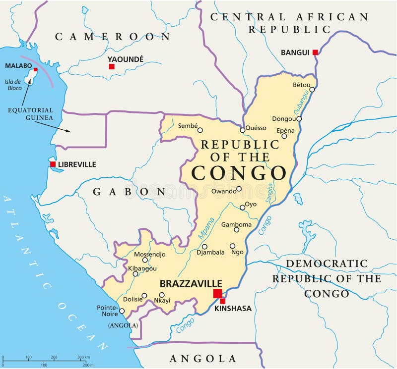
Free with trial Political map of the Republic of the Congo with capital Brazzaville, with national borders, most important cities, rivers and lakes. Illustration with English labeling and scaling. Libreville map vectors Republic of the Congo Political Map. Political map of the Republic of the Congo with capital Brazzaville, with national borders, most important cities, rivers and lakes. Illustration with English labeling and scaling.
Free with trial Vector file of Africa Continent map, black continent. Libreville map illustrations Africa Continent map
Free with trial Gabon, Libreville - capital city, pinned on political map - 3D illustration. Libreville map illustrations Gabon, Libreville - capital city, pinned on political map
Free with trial Gabon,political map. Gabonese Republic,a country on the Atlantic coast of Central Africa,with capital Libreville. Bordered by Equatorial Guinea,Cameroon,Republic of the Congo,and Gulf of Guinea. Libreville map vectors Gabon, the Gabonese Republic, a country in Central Africa, political map. Gabon,political map. Gabonese Republic,a country on the Atlantic coast of Central Africa,with capital Libreville. Bordered by Equatorial Guinea,Cameroon,Republic of the Congo,and Gulf of Guinea.
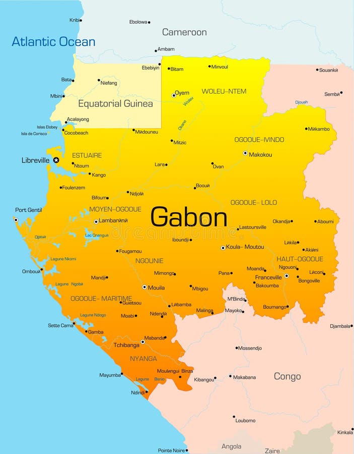
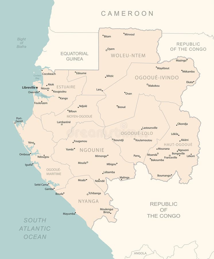
Free with trial Highly detailed vector map of Gabon with administrative regions, main cities and roads. Libreville map vectors Gabon map. Highly detailed vector map of Gabon with administrative regions, main cities and roads.
Free with trial The Republic of the Congo political map highlights its capital, Brazzaville, along with major cities. Libreville map vectors Republic of the Congo Political Map with capital Brazzaville, most important cities with national borders. The Republic of the Congo political map highlights its capital, Brazzaville, along with major cities
Free with trial 3d made flag map of Gabon. Libreville map illustrations 3d flag map of Gabon. 3d made flag map of Gabon
Free with trial Africa map with Gabon and tourism. Libreville map illustrations Africa map with Gabon
Free with trial Abstract blue world map with magnified Gabon. Gabon flag and map. Vector Illustration. Libreville map vectors Abstract blue world map with magnified Gabon.
Free with trial Zoom on Gabon Map and Flag. World Map. Libreville map vectors Zoom on Gabon Map and Flag. World Map
Free with trial Vector sketch map of the Gabon with flag, hand drawn chalk illustration. Libreville map vectors Gabon vector map with flag inside isolated on a white background. Sketch chalk hand drawn illustration. Vector sketch map of the Gabon with flag, hand drawn chalk illustration.
Free with trial Puzzle with the national flag of cameroon and gabon on a world map background. 3D illustration. Libreville map illustrations Puzzle with the national flag of cameroon and gabon on a world map. puzzle with the national flag of cameroon and gabon on a world map background. 3D illustration
Free with trial Administrative division of the Gabonese Republic. Libreville map vectors Gabon map. Administrative division of the Gabonese Republic
Free with trial Gabon area map in the Azimuthal Equidistant projection. shapes only - land/ocean mask. Overlay with clean background without borders. Libreville map illustrations Gabon - solid. Overlay. Gabon area map in the Azimuthal Equidistant projection. shapes only - land/ocean mask. Overlay with clean background without borders
Free with trial Gabon sunburst badge. The country sign with map of Gabon with Gabonese flag. Colorful rays around the logo. Vector illustration. Libreville map vectors Gabon sunburst badge.
Free with trial Black silhouette of the country Gabon with the contour line or frame. Effect of stickers, tag and label. Vector illustration. Libreville map illustrations Black silhouette of the country Gabon with the contour line or f
Free with trial The area of Gabon centered in the circle surrounding its continent on the desaturated background. Capital georeferences and names given. Satellite imagery. Libreville map illustrations Gabon - satellite. Continent. The area of Gabon centered in the circle surrounding its continent on the desaturated background. Capital georeferences and names given. Satellite imagery
Free with trial Gabon Libreville Retro Typography Map. Libreville map illustrations Gabon Libreville Typography Map. Gabon Libreville Retro Typography Map
Free with trial Gabon Libreville Round Seal Map Design. Libreville map vectors Gabon Libreville Seal Map Design. Gabon Libreville Round Seal Map Design
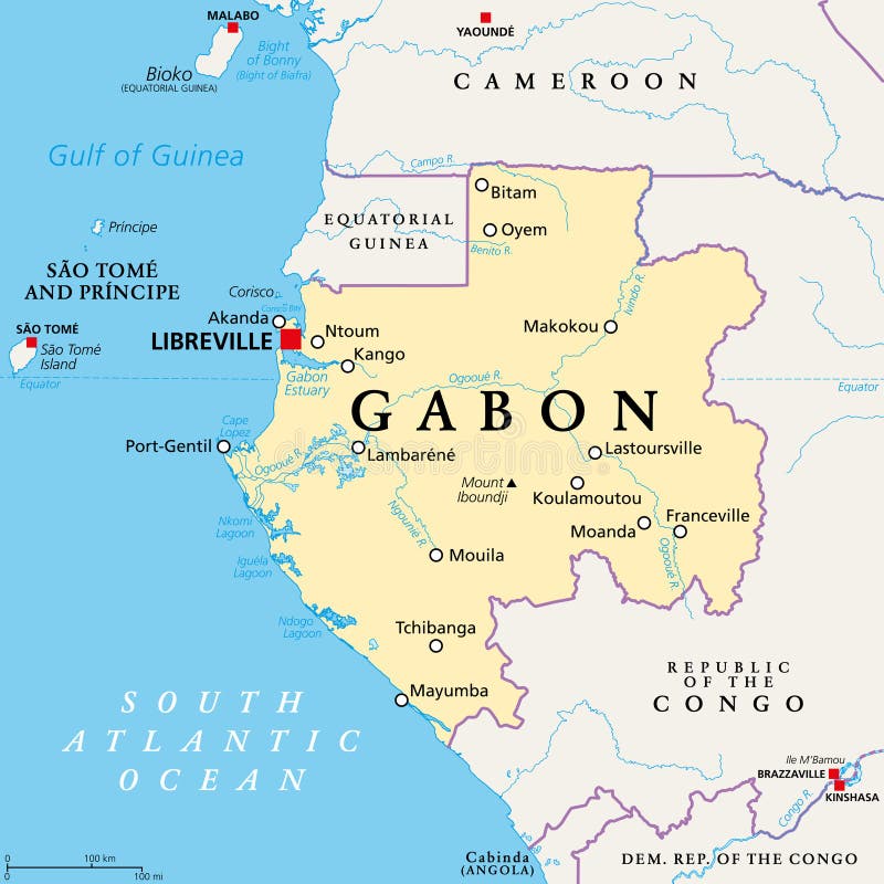
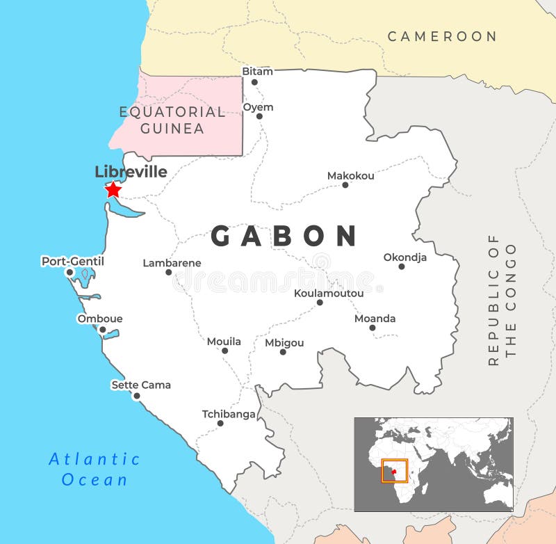
Free with trial Gabon Political Map showing the capital Libreville, key cities, and national borders, highlighting its position in Central Africa. Libreville map illustrations Gabon Political Map with capital Libreville, most important cities with national borders. Gabon Political Map showing the capital Libreville, key cities, and national borders, highlighting its position in Central Africa
Free with trial Gabon, Libreville - push pin on political map - 3D illustration. Libreville map illustrations Gabon, Libreville - push pin on political map
Free with trial Libreville capital city of Gabon,Urban Streets Roads Map with city center location pin, illustration vector element image. Libreville map vectors Libreville, Gabon,Urban Streets Roads Map with location pin. Libreville capital city of Gabon,Urban Streets Roads Map with city center location pin, illustration vector element image
Free with trial Gabon Libreville Round Seal Map Design. Libreville map illustrations Gabon Libreville Seal Map Design. Gabon Libreville Round Seal Map Design
Free with trial Green Libreville map, Gabon, detailed municipality map, skyline panorama. Decorative graphic tourist map of Libreville territory. Royalty free vector illustration. Libreville map vectors Green Libreville map, Gabon, detailed municipality map, skyline panorama. Decorative graphic tourist map of Libreville territory.
Free with trial Gabon, Libreville - location pin with national flag on political map - 3D illustration. Libreville map illustrations Gabon, Libreville - location pin with national flag on political map
Free with trial The map is not a big beautiful city. The capital of Gabon is Libreville. Libreville map illustrations Map of the city of Libreville. The map is not a big beautiful city. The capital of Gabon is Libreville.
Free with trial Gabon Libreville Gold Typography Stamp Design. Libreville map illustrations Gabon Libreville Seal Map Design. Gabon Libreville Gold Typography Stamp Design
Free with trial Gabon country dotted map. Black spot pixel illustration isolated on white background. Vector circle mosaic. Libreville map illustrations Gabon dotted vector map. Gabon country dotted map. Black spot pixel illustration isolated on white background. Vector circle mosaic.
Free with trial Gabon country silhouette. Vector map silhouette. Blue smooth shape like water drop or splash. Libreville map illustrations Gabon water drop map silhouette. Gabon country silhouette. Vector map silhouette. Blue smooth shape like water drop or splash
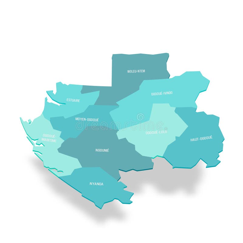
Free with trial Gabon political map of administrative divisions - provinces. Colorful isometric blank vector map. Libreville map vectors Gabon political map of administrative divisions
Free with trial Gabon political map of administrative divisions - provinces. Rainbow spectrum colorful blank vector map. Libreville map vectors Gabon political map of administrative divisions
Free with trial Gabon political map of administrative divisions - provinces. Colorful handdrawn doodle style map with black outline borders and name labels. Libreville map illustrations Gabon political map of administrative divisions
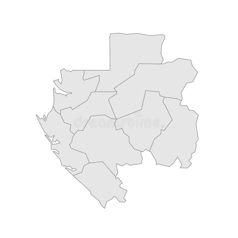
Free with trial Gabon political map of administrative divisions - provinces. Grey map with thin black outline and labels. Libreville map illustrations Gabon political map of administrative divisions. Provinces. Grey map with thin black outline and labels
Free with trial Stylized Map of Gabon with Neighboring Areas. Map in a modern, minimalistic style with soft gradient colors. Libreville map vectors Stylized Map of Gabon with Neighboring Areas
Free with trial Gabon country dotted map. Black spot pixel illustration isolated on white background. Vector circle mosaic. Libreville map illustrations Gabon dotted vector map. Gabon country dotted map. Black spot pixel illustration isolated on white background. Vector circle mosaic.
Free with trial Gabon country dotted map. Black spot pixel illustration isolated on white background. Vector circle mosaic. Libreville map illustrations Gabon dotted vector map. Gabon country dotted map. Black spot pixel illustration isolated on white background. Vector circle mosaic.
Free with trial Cameroon line, volcanic island chain off the coast of West Africa, gray political map. Volcano chain including islands in the Gulf of Guinea in the Atlantic Ocean and mountains on mainland of Africa. Libreville map vectors Cameroon line, volcanic island chain of West Africa, gray political map. Cameroon line, volcanic island chain off the coast of West Africa, gray political map. Volcano chain including islands in the Gulf of Guinea in the Atlantic Ocean and mountains on mainland of Africa.
Free with trial Gabon high detailed vector representation of country silhouette. 3D map on transparent background with dropped shadow. For educational, decorative, or informational use. Libreville map vectors Gabon vector map silhouette. Gabon high detailed vector representation of country silhouette. 3D map on transparent background with dropped shadow. For educational, decorative, or informational use.
Free with trial Gabon Libreville Sustainable Tourism Concept. Libreville map illustrations Gabon Libreville Sustainable Travel. Gabon Libreville Sustainable Tourism Concept
Free with trial Gabon Libreville Vintage Mail Envelope, Postmark. Libreville map illustrations Gabon Libreville Vintage Mail Envelope
Free with trial Vintage Map Of Central Africa On Retro Paper Background. Libreville map illustrations Vintage Map Of Central Africa On Retro Paper
Free with trial Gabon country silhouette. High detailed map. Solid blue vector sticker with white contour isolated on white background. Libreville map vectors Gabon vector country map sticker. Gabon country silhouette. High detailed map. Solid blue vector sticker with white contour isolated on white background.
Free with trial Abstract Map of Gabon and Surrounding Regions with Circular Patterns. Vibrant Abstract Map. Libreville map vectors Abstract Map of Gabon and Surrounding Regions with Circular Patterns
Free with trial Vintage Map Of Gabon With Provincial Boundaries On Retro Paper Background. Libreville map illustrations Vintage Map Of Gabon With Provincial Boundaries On Retro Paper
Free with trial Gabon - Dotted Map. Map formed by Dots. Vector Illustration. Libreville map illustrations Gabon - Dotted Map. Map formed by Dots. Vector Illustration
Free with trial 3D Isometric Map Highlighting Gabon in Red. Vector illustration. Libreville map vectors 3D Isometric Map Highlighting Gabon in Red
Free with trial Gabon country simplified map. Orange silhouette with thick black sharp contour outline isolated on white background. Simple vector icon. Libreville map illustrations Gabon simplified vector map. Gabon country simplified map. Orange silhouette with thick black sharp contour outline isolated on white background. Simple vector icon
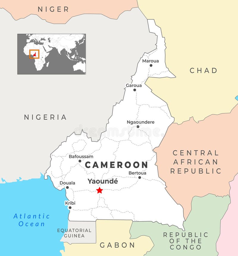
Free with trial Cameroon political map shows its capital Yaound� and includes key cities like Douala, Garoua, and Bafoussam, with national borders shared with Nigeria, Chad, Central African Republic, Congo, and Gabon. Libreville map illustrations Cameroon Political Map with capital Yaounde, most important cities with national borders. Cameroon political map shows its capital Yaound� and includes key cities like Douala, Garoua, and Bafoussam, with national borders shared with Nigeria, Chad, Central African Republic, Congo, and Gabon
Free with trial Gabon country simplified map. White silhouette with thick black contour on yellow background. Simple vector icon. Libreville map vectors Gabon simplified vector map. Gabon country simplified map. White silhouette with thick black contour on yellow background. Simple vector icon
Free with trial Gabon country simplified map. Violet silhouette with thin black smooth contour outline isolated on white background. Simple vector icon. Libreville map vectors Gabon simplified vector map. Gabon country simplified map. Violet silhouette with thin black smooth contour outline isolated on white background. Simple vector icon
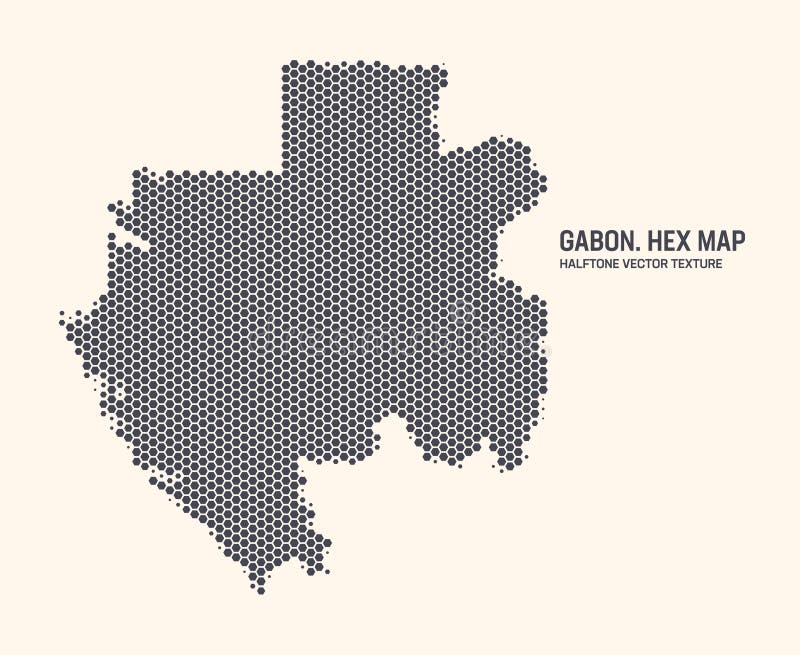
Free with trial Gabon Map Vector Hexagonal Halftone Pattern Isolate On Light Background. Hex Texture in the Form of a Map of Gabon. Modern Technological Military Contour Map of Gabon for Design or Business Projects. Libreville map vectors Gabon Map Vector Hexagonal Half Tone Pattern Isolated On Light Background. Gabon Map Vector Hexagonal Halftone Pattern Isolate On Light Background. Hex Texture in the Form of a Map of Gabon. Modern Technological Military Contour Map of Gabon for Design or Business Projects
Free with trial Gabon country simplified map. Thin triple pencil sketch outline isolated on white background. Simple vector icon. Libreville map vectors Gabon simplified sketch map. Gabon country simplified map.Thin triple pencil sketch outline isolated on white background. Simple vector icon
Free with trial Gabon political map of administrative divisions - provinces. Grey blank vector editable map EPS. Libreville map vectors Gabon editable vector political map EPS. Gabon political map of administrative divisions - provinces. Grey blank vector editable map EPS.
Free with trial Gabon country simplified map. Black broken outline contour on white background. Simple vector icon. Libreville map vectors Gabon simplified broken outline vector map. Gabon country simplified map. Black broken outline contour on white background. Simple vector icon
Free with trial Gabon country thick black outline silhouette. Simplified map. Vector icon isolated on white background. Libreville map vectors Gabon vector country map thick outline icon. Gabon country thick black outline silhouette. Simplified map. Vector icon isolated on white background.
Free with trial Gabon country simplified map. Thick black outline contour. Simple vector icon. Libreville map vectors Gabon simplified vector outline map. Gabon country simplified map. Thick black outline contour. Simple vector icon
Free with trial Gabon Libreville Stamps Collection on Paper. Libreville map illustrations Gabon Libreville Stamps on Paper. Gabon Libreville Stamps Collection on Paper
Free with trial Gabon country simplified map. Violet silhouette with thin black smooth contour outline isolated on white background. Simple vector icon. Libreville map vectors Gabon simplified vector map. Gabon country simplified map. Violet silhouette with thin black smooth contour outline isolated on white background. Simple vector icon
Free with trial Simple solid green outline map showing Gabon's shape without labels or borders. Libreville map vectors Gabon Map Boundary. Simple solid green outline map showing Gabon's shape without labels or borders.
Free with trial Gabon - blue map with neighboring countries and names. Vector illustration. Libreville map illustrations Gabon - blue map with neighboring countries and names
Free with trial Gabon political map of administrative divisions - provinces. Green flat vector map with dropped shadow and division name labels. Libreville map vectors Gabon political map of administrative divisions
Free with trial Gabon political map of administrative divisions - provinces. 3D isometric blank vector map in shades of grey. Libreville map vectors Gabon political map of administrative divisions
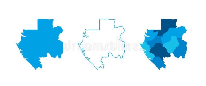
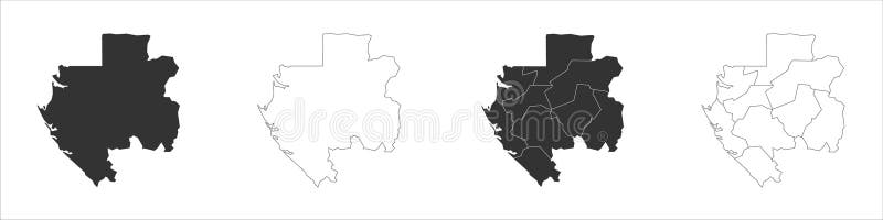
Free with trial Gabon set of three maps - solid map, outline map and map highlighting administrative divisions. Three distinct maps illustrate various representations of a geographical area. Libreville map vectors Gabon political map of administrative divisions. Gabon set of three maps - solid map, outline map and map highlighting administrative divisions. Three distinct maps illustrate various representations of a geographical area.
Free with trial Gabon set of three maps - solid map, outline map and map highlighting administrative divisions. Three distinct maps illustrate various representations of a geographical area. Libreville map vectors Gabon political map of administrative divisions. Gabon set of three maps - solid map, outline map and map highlighting administrative divisions. Three distinct maps illustrate various representations of a geographical area.
Free with trial Gabon political map of administrative divisions - provinces. 3D turquoise vector map with name labels. Libreville map vectors Gabon political map of administrative divisions
Free with trial Gabon highlighted on a detailed map, geographic location of Gabon. Vector Map. Libreville map vectors Gabon highlighted on a detailed map, geographic location of Gabon
Free with trial Gabon Map in Blue with Gold Framed Accents. Modern Vector Map of Gabon. Vector Illustration. Libreville map vectors Gabon Map in Blue with Gold Framed Accents. Modern Vector Map of Gabon
Free with trial Gabon - detailed map with administrative divisions country. Vector illustration. Libreville map illustrations Gabon - detailed map with administrative divisions country
Free with trial 3D Gabon map with flag. Three dimensional map of Gabon with shadow. Flag Gabonese Republic on white background for your design, app, UI. Stock vector. EPS10. Libreville map vectors 3D Gabon map with flag. Three dimensional map of Gabon with shadow. Flag Gabonese Republic on white background
Free with trial Gabon Country Map Featuring National Flag Colors. Vector illustration. Libreville map vectors Gabon Country Map Featuring National Flag Colors
Free with trial Gabon Highlighted on World Map with National Flag. Vector world map with Gabon highlighted using its national flag. Libreville map vectors Gabon Highlighted on World Map with National Flag. Gabon Map and Flag. Gabon Highlighted on World Map with National Flag. Vector world map with Gabon highlighted using its national flag
Free with trial Gabon shape whith country names word cloud in multiple languages. Gabon border map on classy triangles scattered around. Powerful vector illustration. Libreville map vectors Gabon shape whith country names word cloud in multiple languages. Gabon border map on classy triangles scattered around
Free with trial Gabon Libreville Old Style Mail Envelope with Flag and Postmark. Libreville map illustrations Gabon Libreville Old Style Mail Envelope
Free with trial Gabon Map Pin with National Flag on Open World Map. Perfect for use in travel guides, geography content, global positioning concepts, and international business themes. Libreville map vectors Gabon Map Pin with National Flag on Open World Map
Free with trial Gabon - Map of the country formed by lines. Vector Illustration. Libreville map illustrations Gabon - Map of the country formed by lines
Free with trial Gabon Location Highlighted on African Map with Flag Icon. Detailed Vector Design. Libreville map vectors Gabon Location Highlighted on African Map with Flag Icon