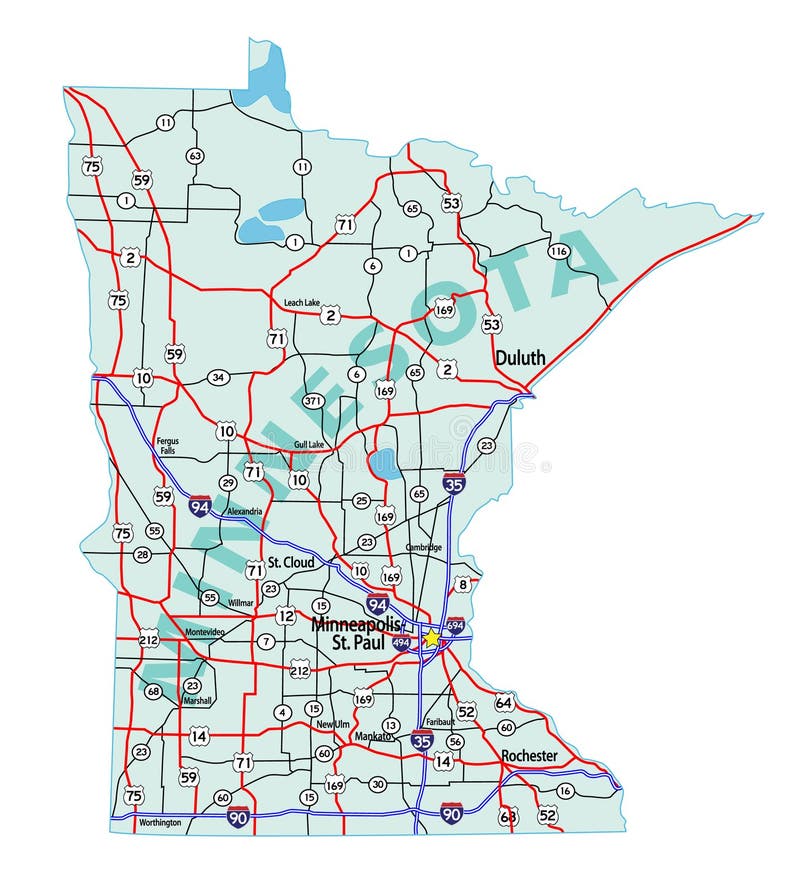
Free with trial Minnesota state road map with Interstates, U. S. Highways and state roads. All elements on separate layers for easy editing. Minnesota map roads vectors Minnesota State Interstate Map. Minnesota state road map with Interstates, U.S. Highways and state roads. All elements on separate layers for easy editing.
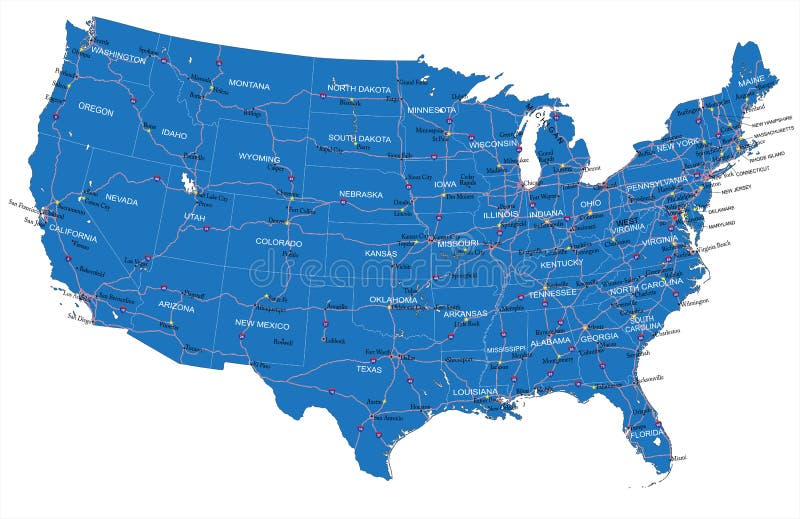
Free with trial Highly detailed vector map of U. S. A. with administrative regions,main cities and roads. Minnesota map roads vectors U.S.A. road map. Highly detailed vector map of U.S.A. with administrative regions,main cities and roads.
Free with trial Vintage wall art map of Hastings, located in Dakota, Minnesota, United States. Aerial plan with forests, roads, cities, lakes and rivers. Minnesota map roads illustrations Retro US map of Hastings, Minnesota. Vintage street map. Vintage wall art map of Hastings, located in Dakota, Minnesota, United States. Aerial plan with forests, roads, cities, lakes and rivers.
Free with trial This lovely pocket map with original color was published at the end of the California Gold Rush in order to illustrate all the known routes to California. This was a time when many territorial borders were in interesting configurations which would eventually evolve into states. Eight large territories in fact make up the majority of the territory covered by the Western United States, which would finally become fifteen states in all. These territories as named at the time included Washington, Oregon, Northwest, Minnesota, Utah, New Mexico, Nebraska, and Indian Territory. The map is rendered in great detail and includes transportation systems such as rivers, railroads, wagon roads and some railroad lines, in addition to oceanic shipping routes. These details extend to include portions of Canada, Central America, northern South America and all of the Caribbean Islands. Sea routes between various ports are painstakingly depicted, along with lovely vignettes of sailboats and steamships, with a table at the lower left listing the distances between ports. Minnesota map roads illustrations 1854 Map of the United States, Canada, Mexico and the West Indies with Central America, Showing All the Routes to California with. This lovely pocket map with original color was published at the end of the California Gold Rush in order to illustrate all the known routes to California. This was a time when many territorial borders were in interesting configurations which would eventually evolve into states. Eight large territories in fact make up the majority of the territory covered by the Western United States, which would finally become fifteen states in all. These territories as named at the time included Washington, Oregon, Northwest, Minnesota, Utah, New Mexico, Nebraska, and Indian Territory. The map is rendered in great detail and includes transportation systems such as rivers, railroads, wagon roads and some railroad lines, in addition to oceanic shipping routes. These details extend to include portions of Canada, Central America, northern South America and all of the Caribbean Islands. Sea routes between various ports are painstakingly depicted, along with lovely vignettes of sailboats and steamships, with a table at the lower left listing the distances between ports.
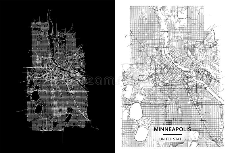
Free with trial High printable detail travel vector map with water objects, roads, railways. Minnesota map roads vectors Minneapolis, Minnesota, United States street map city centre for poster. High printable detail travel vector map. High printable detail travel vector map with water objects, roads, railways.
Free with trial Saint Paul map, capital city of the USA state of Minnesota. Municipal administrative area map with rivers and roads, parks and railways. Vector illustration. Minnesota map roads vectors Saint Paul map, capital city of the USA state of Minnesota. Municipal administrative area map with rivers and roads, parks and
Free with trial Background Saint Paul map, Minnesota, green city poster. Vector map with roads and water. Widescreen proportion, digital flat design roadmap. Minnesota map roads vectors Background Saint Paul map, Minnesota, green city poster. Vector map with roads and water. Widescreen proportion, flat design
Free with trial Explore the intricate urban landscape of Saint Paul, Minnesota with this meticulously detailed map. This comprehensive visual guide showcases the city's municipal administrative area, providing a clear overview of the city's geographical layout. Delve into the intricate network of roads, highlighting major thoroughfares and local streets. The map visually represents the city's extensive park. Minnesota map roads illustrations Comprehensive Saint Paul Minnesota Map Detailed View of City Administrative Boundaries Waterways Roads Parks and Rail. Explore the intricate urban landscape of Saint Paul, Minnesota with this meticulously detailed map. This comprehensive visual guide showcases the city's municipal administrative area, providing a clear overview of the city's geographical layout. Delve into the intricate network of roads, highlighting major thoroughfares and local streets. The map visually represents the city's extensive park
Free with trial Explore the intricate street network and urban landscape of Sauk Rapids, Minnesota, with this captivating black and white aerial street map. This detailed bird eye view provides a comprehensive overview of the city infrastructure, showcasing roads, streets, residential areas, commercial districts, and industrial zones. The map highlights the town geographic features, including rivers, parks, and. Minnesota map roads illustrations Detailed Aerial Street Map of Sauk Rapids Minnesota Black and White Birds Eye View for Urban Planning and. Explore the intricate street network and urban landscape of Sauk Rapids, Minnesota, with this captivating black and white aerial street map. This detailed bird eye view provides a comprehensive overview of the city infrastructure, showcasing roads, streets, residential areas, commercial districts, and industrial zones. The map highlights the town geographic features, including rivers, parks, and
Free with trial A detailed topographic map of Minneapolis, Minnesota, displays roads, highways, natural features, lakes, rivers and green areas with a hilly terrain. Useful for geographic studies, travel planning. Minnesota map roads illustrations Detailed Topographic Map of Minneapolis Minnesota Showing Roads Highways and Natural Features with Lakes Rivers and Green Areas. A detailed topographic map of Minneapolis, Minnesota, displays roads, highways, natural features, lakes, rivers and green areas with a hilly terrain. Useful for geographic studies, travel planning
Free with trial Minneapolis, MN, USA Stamp Map Postal. Silhouette Seal Roads and Streets. Passport Round Design. Vector Icon. Design Retro Travel National Symbol. Minnesota map roads vectors Minneapolis, MN, USA Stamp Map Postal. Silhouette Seal Roads and Streets. Passport Round Design. Vector Icon. Design Retro Travel National Symbol
Free with trial Vintage wall art map of Hugo, located in Washington, Minnesota, United States. Aerial plan with forests, roads, cities, lakes and rivers. Minnesota map roads illustrations Retro US map of Hugo, Minnesota. Vintage street map. Vintage wall art map of Hugo, located in Washington, Minnesota, United States. Aerial plan with forests, roads, cities, lakes and rivers.
Free with trial Vintage wall art map of Mora, located in Kanabec, Minnesota, United States. Aerial plan with forests, roads, cities, lakes and rivers. Minnesota map roads illustrations Retro US map of Mora, Minnesota. Vintage street map. Vintage wall art map of Mora, located in Kanabec, Minnesota, United States. Aerial plan with forests, roads, cities, lakes and rivers.
Free with trial Vintage wall art map of Cedar, located in Anoka, Minnesota, United States. Aerial plan with forests, roads, cities, lakes and rivers. Minnesota map roads illustrations Retro US map of Cedar, Minnesota. Vintage street map. Vintage wall art map of Cedar, located in Anoka, Minnesota, United States. Aerial plan with forests, roads, cities, lakes and rivers.
Free with trial Vintage wall art map of Dalbo, located in Isanti, Minnesota, United States. Aerial plan with forests, roads, cities, lakes and rivers. Minnesota map roads illustrations Retro US map of Dalbo, Minnesota. Vintage street map. Vintage wall art map of Dalbo, located in Isanti, Minnesota, United States. Aerial plan with forests, roads, cities, lakes and rivers.
Free with trial Vintage wall art map of Anoka, located in Anoka, Minnesota, United States. Aerial plan with forests, roads, cities, lakes and rivers. Minnesota map roads illustrations Retro US map of Anoka, Minnesota. Vintage street map. Vintage wall art map of Anoka, located in Anoka, Minnesota, United States. Aerial plan with forests, roads, cities, lakes and rivers.
Free with trial Vintage wall art map of Welch, located in Goodhue, Minnesota, United States. Aerial plan with forests, roads, cities, lakes and rivers. Minnesota map roads illustrations Retro US map of Welch, Minnesota. Vintage street map. Vintage wall art map of Welch, located in Goodhue, Minnesota, United States. Aerial plan with forests, roads, cities, lakes and rivers.
Free with trial Vintage wall art map of Hamel, located in Hennepin, Minnesota, United States. Aerial plan with forests, roads, cities, lakes and rivers. Minnesota map roads illustrations Retro US map of Hamel, Minnesota. Vintage street map. Vintage wall art map of Hamel, located in Hennepin, Minnesota, United States. Aerial plan with forests, roads, cities, lakes and rivers.
Free with trial Vintage wall art map of Mound, located in Hennepin, Minnesota, United States. Aerial plan with forests, roads, cities, lakes and rivers. Minnesota map roads illustrations Retro US map of Mound, Minnesota. Vintage street map. Vintage wall art map of Mound, located in Hennepin, Minnesota, United States. Aerial plan with forests, roads, cities, lakes and rivers.
Free with trial Vintage wall art map of Mayer, located in Carver, Minnesota, United States. Aerial plan with forests, roads, cities, lakes and rivers. Minnesota map roads illustrations Retro US map of Mayer, Minnesota. Vintage street map. Vintage wall art map of Mayer, located in Carver, Minnesota, United States. Aerial plan with forests, roads, cities, lakes and rivers.
Free with trial Vintage wall art map of Osseo, located in Hennepin, Minnesota, United States. Aerial plan with forests, roads, cities, lakes and rivers. Minnesota map roads illustrations Retro US map of Osseo, Minnesota. Vintage street map. Vintage wall art map of Osseo, located in Hennepin, Minnesota, United States. Aerial plan with forests, roads, cities, lakes and rivers.
Free with trial Vintage wall art map of Afton, located in Washington, Minnesota, United States. Aerial plan with forests, roads, cities, lakes and rivers. Minnesota map roads illustrations Retro US map of Afton, Minnesota. Vintage street map. Vintage wall art map of Afton, located in Washington, Minnesota, United States. Aerial plan with forests, roads, cities, lakes and rivers.
Free with trial Vintage wall art map of Stacy, located in Chisago, Minnesota, United States. Aerial plan with forests, roads, cities, lakes and rivers. Minnesota map roads illustrations Retro US map of Stacy, Minnesota. Vintage street map. Vintage wall art map of Stacy, located in Chisago, Minnesota, United States. Aerial plan with forests, roads, cities, lakes and rivers.
Free with trial Vintage wall art map of Plato, located in McLeod, Minnesota, United States. Aerial plan with forests, roads, cities, lakes and rivers. Minnesota map roads illustrations Retro US map of Plato, Minnesota. Vintage street map. Vintage wall art map of Plato, located in McLeod, Minnesota, United States. Aerial plan with forests, roads, cities, lakes and rivers.
Free with trial Vintage wall art map of Gibbon, located in Sibley, Minnesota, United States. Aerial plan with forests, roads, cities, lakes and rivers. Minnesota map roads illustrations Retro US map of Gibbon, Minnesota. Vintage street map. Vintage wall art map of Gibbon, located in Sibley, Minnesota, United States. Aerial plan with forests, roads, cities, lakes and rivers.
Free with trial Vintage wall art map of Dayton, located in Hennepin, Minnesota, United States. Aerial plan with forests, roads, cities, lakes and rivers. Minnesota map roads illustrations Retro US map of Dayton, Minnesota. Vintage street map. Vintage wall art map of Dayton, located in Hennepin, Minnesota, United States. Aerial plan with forests, roads, cities, lakes and rivers.
Free with trial Vintage wall art map of Chaska, located in Carver, Minnesota, United States. Aerial plan with forests, roads, cities, lakes and rivers. Minnesota map roads illustrations Retro US map of Chaska, Minnesota. Vintage street map. Vintage wall art map of Chaska, located in Carver, Minnesota, United States. Aerial plan with forests, roads, cities, lakes and rivers.
Free with trial Vintage wall art map of Carver, located in Carver, Minnesota, United States. Aerial plan with forests, roads, cities, lakes and rivers. Minnesota map roads illustrations Retro US map of Carver, Minnesota. Vintage street map. Vintage wall art map of Carver, located in Carver, Minnesota, United States. Aerial plan with forests, roads, cities, lakes and rivers.
Free with trial Vintage wall art map of Delano, located in Wright, Minnesota, United States. Aerial plan with forests, roads, cities, lakes and rivers. Minnesota map roads illustrations Retro US map of Delano, Minnesota. Vintage street map. Vintage wall art map of Delano, located in Wright, Minnesota, United States. Aerial plan with forests, roads, cities, lakes and rivers.
Free with trial Vintage wall art map of Braham, located in Kanabec, Minnesota, United States. Aerial plan with forests, roads, cities, lakes and rivers. Minnesota map roads illustrations Retro US map of Braham, Minnesota. Vintage street map. Vintage wall art map of Braham, located in Kanabec, Minnesota, United States. Aerial plan with forests, roads, cities, lakes and rivers.
Free with trial Vintage wall art map of Bethel, located in Anoka, Minnesota, United States. Aerial plan with forests, roads, cities, lakes and rivers. Minnesota map roads illustrations Retro US map of Bethel, Minnesota. Vintage street map. Vintage wall art map of Bethel, located in Anoka, Minnesota, United States. Aerial plan with forests, roads, cities, lakes and rivers.
Free with trial Vintage wall art map of Savage, located in Scott, Minnesota, United States. Aerial plan with forests, roads, cities, lakes and rivers. Minnesota map roads illustrations Retro US map of Savage, Minnesota. Vintage street map. Vintage wall art map of Savage, located in Scott, Minnesota, United States. Aerial plan with forests, roads, cities, lakes and rivers.
Free with trial Vintage wall art map of Dassel, located in Meeker, Minnesota, United States. Aerial plan with forests, roads, cities, lakes and rivers. Minnesota map roads illustrations Retro US map of Dassel, Minnesota. Vintage street map. Vintage wall art map of Dassel, located in Meeker, Minnesota, United States. Aerial plan with forests, roads, cities, lakes and rivers.
Free with trial Vintage wall art map of Grandy, located in Isanti, Minnesota, United States. Aerial plan with forests, roads, cities, lakes and rivers. Minnesota map roads illustrations Retro US map of Grandy, Minnesota. Vintage street map. Vintage wall art map of Grandy, located in Isanti, Minnesota, United States. Aerial plan with forests, roads, cities, lakes and rivers.
Free with trial Vintage wall art map of Cokato, located in Wright, Minnesota, United States. Aerial plan with forests, roads, cities, lakes and rivers. Minnesota map roads illustrations Retro US map of Cokato, Minnesota. Vintage street map. Vintage wall art map of Cokato, located in Wright, Minnesota, United States. Aerial plan with forests, roads, cities, lakes and rivers.
Free with trial Vintage wall art map of Darwin, located in Meeker, Minnesota, United States. Aerial plan with forests, roads, cities, lakes and rivers. Minnesota map roads illustrations Retro US map of Darwin, Minnesota. Vintage street map. Vintage wall art map of Darwin, located in Meeker, Minnesota, United States. Aerial plan with forests, roads, cities, lakes and rivers.
Free with trial Vintage wall art map of Isanti, located in Isanti, Minnesota, United States. Aerial plan with forests, roads, cities, lakes and rivers. Minnesota map roads illustrations Retro US map of Isanti, Minnesota. Vintage street map. Vintage wall art map of Isanti, located in Isanti, Minnesota, United States. Aerial plan with forests, roads, cities, lakes and rivers.
Free with trial Vintage wall art map of Shafer, located in Chisago, Minnesota, United States. Aerial plan with forests, roads, cities, lakes and rivers. Minnesota map roads illustrations Retro US map of Shafer, Minnesota. Vintage street map. Vintage wall art map of Shafer, located in Chisago, Minnesota, United States. Aerial plan with forests, roads, cities, lakes and rivers.
Free with trial Vintage wall art map of Hector, located in Renville, Minnesota, United States. Aerial plan with forests, roads, cities, lakes and rivers. Minnesota map roads illustrations Retro US map of Hector, Minnesota. Vintage street map. Vintage wall art map of Hector, located in Renville, Minnesota, United States. Aerial plan with forests, roads, cities, lakes and rivers.
Free with trial Vintage wall art map of Dundas, located in Rice, Minnesota, United States. Aerial plan with forests, roads, cities, lakes and rivers. Minnesota map roads illustrations Retro US map of Dundas, Minnesota. Vintage street map. Vintage wall art map of Dundas, located in Rice, Minnesota, United States. Aerial plan with forests, roads, cities, lakes and rivers.
Free with trial Vintage wall art map of Harris, located in Chisago, Minnesota, United States. Aerial plan with forests, roads, cities, lakes and rivers. Minnesota map roads illustrations Retro US map of Harris, Minnesota. Vintage street map. Vintage wall art map of Harris, located in Chisago, Minnesota, United States. Aerial plan with forests, roads, cities, lakes and rivers.
Free with trial Vintage wall art map of Rogers, located in Hennepin, Minnesota, United States. Aerial plan with forests, roads, cities, lakes and rivers. Minnesota map roads illustrations Retro US map of Rogers, Minnesota. Vintage street map. Vintage wall art map of Rogers, located in Hennepin, Minnesota, United States. Aerial plan with forests, roads, cities, lakes and rivers.
Free with trial Vintage wall art map of Jordan, located in Scott, Minnesota, United States. Aerial plan with forests, roads, cities, lakes and rivers. Minnesota map roads illustrations Retro US map of Jordan, Minnesota. Vintage street map. Vintage wall art map of Jordan, located in Scott, Minnesota, United States. Aerial plan with forests, roads, cities, lakes and rivers.
Free with trial Vintage wall art map of Warsaw, located in Rice, Minnesota, United States. Aerial plan with forests, roads, cities, lakes and rivers. Minnesota map roads illustrations Retro US map of Warsaw, Minnesota. Vintage street map. Vintage wall art map of Warsaw, located in Rice, Minnesota, United States. Aerial plan with forests, roads, cities, lakes and rivers.
Free with trial Vintage wall art map of Becker, located in Sherburne, Minnesota, United States. Aerial plan with forests, roads, cities, lakes and rivers. Minnesota map roads illustrations Retro US map of Becker, Minnesota. Vintage street map. Vintage wall art map of Becker, located in Sherburne, Minnesota, United States. Aerial plan with forests, roads, cities, lakes and rivers.
Free with trial Vintage wall art map of Hanover, located in Wright, Minnesota, United States. Aerial plan with forests, roads, cities, lakes and rivers. Minnesota map roads illustrations Retro US map of Hanover, Minnesota. Vintage street map. Vintage wall art map of Hanover, located in Wright, Minnesota, United States. Aerial plan with forests, roads, cities, lakes and rivers.
Free with trial Vintage wall art map of Glencoe, located in McLeod, Minnesota, United States. Aerial plan with forests, roads, cities, lakes and rivers. Minnesota map roads illustrations Retro US map of Glencoe, Minnesota. Vintage street map. Vintage wall art map of Glencoe, located in McLeod, Minnesota, United States. Aerial plan with forests, roads, cities, lakes and rivers.
Free with trial Vintage wall art map of Mendota, located in Dakota, Minnesota, United States. Aerial plan with forests, roads, cities, lakes and rivers. Minnesota map roads illustrations Retro US map of Mendota, Minnesota. Vintage street map. Vintage wall art map of Mendota, located in Dakota, Minnesota, United States. Aerial plan with forests, roads, cities, lakes and rivers.
Free with trial Vintage wall art map of Cologne, located in Carver, Minnesota, United States. Aerial plan with forests, roads, cities, lakes and rivers. Minnesota map roads illustrations Retro US map of Cologne, Minnesota. Vintage street map. Vintage wall art map of Cologne, located in Carver, Minnesota, United States. Aerial plan with forests, roads, cities, lakes and rivers.
Free with trial Vintage wall art map of Fairfax, located in Renville, Minnesota, United States. Aerial plan with forests, roads, cities, lakes and rivers. Minnesota map roads illustrations Retro US map of Fairfax, Minnesota. Vintage street map. Vintage wall art map of Fairfax, located in Renville, Minnesota, United States. Aerial plan with forests, roads, cities, lakes and rivers.
Free with trial Vintage wall art map of Watkins, located in Meeker, Minnesota, United States. Aerial plan with forests, roads, cities, lakes and rivers. Minnesota map roads illustrations Retro US map of Watkins, Minnesota. Vintage street map. Vintage wall art map of Watkins, located in Meeker, Minnesota, United States. Aerial plan with forests, roads, cities, lakes and rivers.
Free with trial Vintage wall art map of Winsted, located in McLeod, Minnesota, United States. Aerial plan with forests, roads, cities, lakes and rivers. Minnesota map roads illustrations Retro US map of Winsted, Minnesota. Vintage street map. Vintage wall art map of Winsted, located in McLeod, Minnesota, United States. Aerial plan with forests, roads, cities, lakes and rivers.
Free with trial Vintage wall art map of Newport, located in Washington, Minnesota, United States. Aerial plan with forests, roads, cities, lakes and rivers. Minnesota map roads illustrations Retro US map of Newport, Minnesota. Vintage street map. Vintage wall art map of Newport, located in Washington, Minnesota, United States. Aerial plan with forests, roads, cities, lakes and rivers.
Free with trial Vintage wall art map of Andover, located in Anoka, Minnesota, United States. Aerial plan with forests, roads, cities, lakes and rivers. Minnesota map roads illustrations Retro US map of Andover, Minnesota. Vintage street map. Vintage wall art map of Andover, located in Anoka, Minnesota, United States. Aerial plan with forests, roads, cities, lakes and rivers.
Free with trial Vintage wall art map of Loretto, located in Hennepin, Minnesota, United States. Aerial plan with forests, roads, cities, lakes and rivers. Minnesota map roads illustrations Retro US map of Loretto, Minnesota. Vintage street map. Vintage wall art map of Loretto, located in Hennepin, Minnesota, United States. Aerial plan with forests, roads, cities, lakes and rivers.
Free with trial Vintage wall art map of Stewart, located in McLeod, Minnesota, United States. Aerial plan with forests, roads, cities, lakes and rivers. Minnesota map roads illustrations Retro US map of Stewart, Minnesota. Vintage street map. Vintage wall art map of Stewart, located in McLeod, Minnesota, United States. Aerial plan with forests, roads, cities, lakes and rivers.
Free with trial Vintage wall art map of Goodhue, located in Goodhue, Minnesota, United States. Aerial plan with forests, roads, cities, lakes and rivers. Minnesota map roads illustrations Retro US map of Goodhue, Minnesota. Vintage street map. Vintage wall art map of Goodhue, located in Goodhue, Minnesota, United States. Aerial plan with forests, roads, cities, lakes and rivers.
Free with trial Vintage wall art map of Gaylord, located in Sibley, Minnesota, United States. Aerial plan with forests, roads, cities, lakes and rivers. Minnesota map roads illustrations Retro US map of Gaylord, Minnesota. Vintage street map. Vintage wall art map of Gaylord, located in Sibley, Minnesota, United States. Aerial plan with forests, roads, cities, lakes and rivers.
Free with trial Vintage wall art map of Waconia, located in Carver, Minnesota, United States. Aerial plan with forests, roads, cities, lakes and rivers. Minnesota map roads illustrations Retro US map of Waconia, Minnesota. Vintage street map. Vintage wall art map of Waconia, located in Carver, Minnesota, United States. Aerial plan with forests, roads, cities, lakes and rivers.
Free with trial Vintage wall art map of Kimball, located in Stearns, Minnesota, United States. Aerial plan with forests, roads, cities, lakes and rivers. Minnesota map roads illustrations Retro US map of Kimball, Minnesota. Vintage street map. Vintage wall art map of Kimball, located in Stearns, Minnesota, United States. Aerial plan with forests, roads, cities, lakes and rivers.
Free with trial Vintage wall art map of Wyoming, located in Anoka, Minnesota, United States. Aerial plan with forests, roads, cities, lakes and rivers. Minnesota map roads illustrations Retro US map of Wyoming, Minnesota. Vintage street map. Vintage wall art map of Wyoming, located in Anoka, Minnesota, United States. Aerial plan with forests, roads, cities, lakes and rivers.
Free with trial Vintage wall art map of Webster, located in Rice, Minnesota, United States. Aerial plan with forests, roads, cities, lakes and rivers. Minnesota map roads illustrations Retro US map of Webster, Minnesota. Vintage street map. Vintage wall art map of Webster, located in Rice, Minnesota, United States. Aerial plan with forests, roads, cities, lakes and rivers.
Free with trial Vintage wall art map of Bayport, located in Washington, Minnesota, United States. Aerial plan with forests, roads, cities, lakes and rivers. Minnesota map roads illustrations Retro US map of Bayport, Minnesota. Vintage street map. Vintage wall art map of Bayport, located in Washington, Minnesota, United States. Aerial plan with forests, roads, cities, lakes and rivers.
Free with trial Vintage wall art map of Wayzata, located in Hennepin, Minnesota, United States. Aerial plan with forests, roads, cities, lakes and rivers. Minnesota map roads illustrations Retro US map of Wayzata, Minnesota. Vintage street map. Vintage wall art map of Wayzata, located in Hennepin, Minnesota, United States. Aerial plan with forests, roads, cities, lakes and rivers.
Free with trial Vintage wall art map of Scandia, located in Washington, Minnesota, United States. Aerial plan with forests, roads, cities, lakes and rivers. Minnesota map roads illustrations Retro US map of Scandia, Minnesota. Vintage street map. Vintage wall art map of Scandia, located in Washington, Minnesota, United States. Aerial plan with forests, roads, cities, lakes and rivers.
Free with trial Vintage wall art map of Hampton, located in Dakota, Minnesota, United States. Aerial plan with forests, roads, cities, lakes and rivers. Minnesota map roads illustrations Retro US map of Hampton, Minnesota. Vintage street map. Vintage wall art map of Hampton, located in Dakota, Minnesota, United States. Aerial plan with forests, roads, cities, lakes and rivers.
Free with trial Vintage wall art map of Hamburg, located in Carver, Minnesota, United States. Aerial plan with forests, roads, cities, lakes and rivers. Minnesota map roads illustrations Retro US map of Hamburg, Minnesota. Vintage street map. Vintage wall art map of Hamburg, located in Carver, Minnesota, United States. Aerial plan with forests, roads, cities, lakes and rivers.
Free with trial Vintage wall art map of Waverly, located in Wright, Minnesota, United States. Aerial plan with forests, roads, cities, lakes and rivers. Minnesota map roads illustrations Retro US map of Waverly, Minnesota. Vintage street map. Vintage wall art map of Waverly, located in Wright, Minnesota, United States. Aerial plan with forests, roads, cities, lakes and rivers.
Free with trial Vintage wall art map of Medford, located in Steele, Minnesota, United States. Aerial plan with forests, roads, cities, lakes and rivers. Minnesota map roads illustrations Retro US map of Medford, Minnesota. Vintage street map. Vintage wall art map of Medford, located in Steele, Minnesota, United States. Aerial plan with forests, roads, cities, lakes and rivers.
Free with trial Vintage wall art map of Dennison, located in Goodhue, Minnesota, United States. Aerial plan with forests, roads, cities, lakes and rivers. Minnesota map roads illustrations Retro US map of Dennison, Minnesota. Vintage street map. Vintage wall art map of Dennison, located in Goodhue, Minnesota, United States. Aerial plan with forests, roads, cities, lakes and rivers.
Free with trial Vintage wall art map of Big Lake, located in Sherburne, Minnesota, United States. Aerial plan with forests, roads, cities, lakes and rivers. Minnesota map roads illustrations Retro US map of Big Lake, Minnesota. Vintage street map. Vintage wall art map of Big Lake, located in Sherburne, Minnesota, United States. Aerial plan with forests, roads, cities, lakes and rivers.
Free with trial Vintage wall art map of Lakeland, located in Washington, Minnesota, United States. Aerial plan with forests, roads, cities, lakes and rivers. Minnesota map roads illustrations Retro US map of Lakeland, Minnesota. Vintage street map. Vintage wall art map of Lakeland, located in Washington, Minnesota, United States. Aerial plan with forests, roads, cities, lakes and rivers.
Free with trial Vintage wall art map of Rockford, located in Hennepin, Minnesota, United States. Aerial plan with forests, roads, cities, lakes and rivers. Minnesota map roads illustrations Retro US map of Rockford, Minnesota. Vintage street map. Vintage wall art map of Rockford, located in Hennepin, Minnesota, United States. Aerial plan with forests, roads, cities, lakes and rivers.
Free with trial Vintage wall art map of Winthrop, located in Sibley, Minnesota, United States. Aerial plan with forests, roads, cities, lakes and rivers. Minnesota map roads illustrations Retro US map of Winthrop, Minnesota. Vintage street map. Vintage wall art map of Winthrop, located in Sibley, Minnesota, United States. Aerial plan with forests, roads, cities, lakes and rivers.
Free with trial Vintage wall art map of Franklin, located in Renville, Minnesota, United States. Aerial plan with forests, roads, cities, lakes and rivers. Minnesota map roads illustrations Retro US map of Franklin, Minnesota. Vintage street map. Vintage wall art map of Franklin, located in Renville, Minnesota, United States. Aerial plan with forests, roads, cities, lakes and rivers.
Free with trial Vintage wall art map of Victoria, located in Carver, Minnesota, United States. Aerial plan with forests, roads, cities, lakes and rivers. Minnesota map roads illustrations Retro US map of Victoria, Minnesota. Vintage street map. Vintage wall art map of Victoria, located in Carver, Minnesota, United States. Aerial plan with forests, roads, cities, lakes and rivers.
Free with trial Vintage wall art map of Owatonna, located in Steele, Minnesota, United States. Aerial plan with forests, roads, cities, lakes and rivers. Minnesota map roads illustrations Retro US map of Owatonna, Minnesota. Vintage street map. Vintage wall art map of Owatonna, located in Steele, Minnesota, United States. Aerial plan with forests, roads, cities, lakes and rivers.
Free with trial Vintage wall art map of Randolph, located in Dakota, Minnesota, United States. Aerial plan with forests, roads, cities, lakes and rivers. Minnesota map roads illustrations Retro US map of Randolph, Minnesota. Vintage street map. Vintage wall art map of Randolph, located in Dakota, Minnesota, United States. Aerial plan with forests, roads, cities, lakes and rivers.
Free with trial Vintage wall art map of Hinckley, located in Pine, Minnesota, United States. Aerial plan with forests, roads, cities, lakes and rivers. Minnesota map roads illustrations Retro US map of Hinckley, Minnesota. Vintage street map. Vintage wall art map of Hinckley, located in Pine, Minnesota, United States. Aerial plan with forests, roads, cities, lakes and rivers.
Free with trial Vintage wall art map of Champlin, located in Hennepin, Minnesota, United States. Aerial plan with forests, roads, cities, lakes and rivers. Minnesota map roads illustrations Retro US map of Champlin, Minnesota. Vintage street map. Vintage wall art map of Champlin, located in Hennepin, Minnesota, United States. Aerial plan with forests, roads, cities, lakes and rivers.