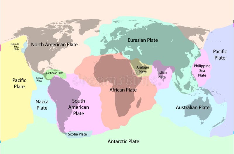
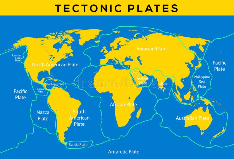
Free with trial Plate tectonics - world map with major an minor plates. Vector illustration. Nazca plate vectors Plate Tectonics
Free with trial A series of maps about the 8. 8 magnitude earthquake from Chile (27 february 2010), from Maule offshore (near Concepcion city). The earthquake was one of the most powerfull from the last 100 years. Nazca plate vectors Chile Earthquake 2010 Map. A series of maps about the 8.8 magnitude earthquake from Chile (27 february 2010), from Maule offshore (near Concepcion city). The earthquake was one of the most powerfull from the last 100 years.
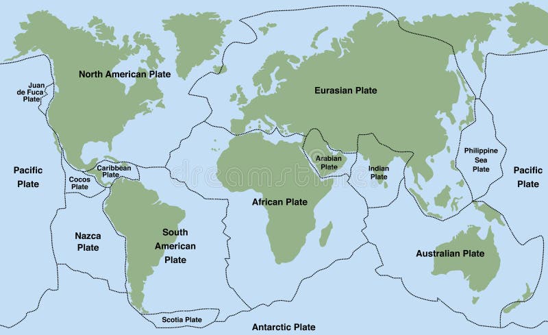
Free with trial Tectonic plate earth map. Continental ocean pacific, volcano lithosphere geography plates. Nazca plate vectors Tectonic plate earth map. Continental ocean pacific, volcano lithosphere geography plates
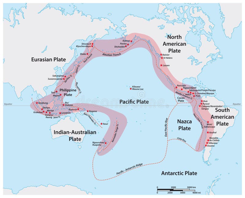
Free with trial Vector map of the Pacific Ring of Fire with the main volcanoes. Nazca plate vectors Vector map of the Pacific Ring of Fire with the main volcanoes
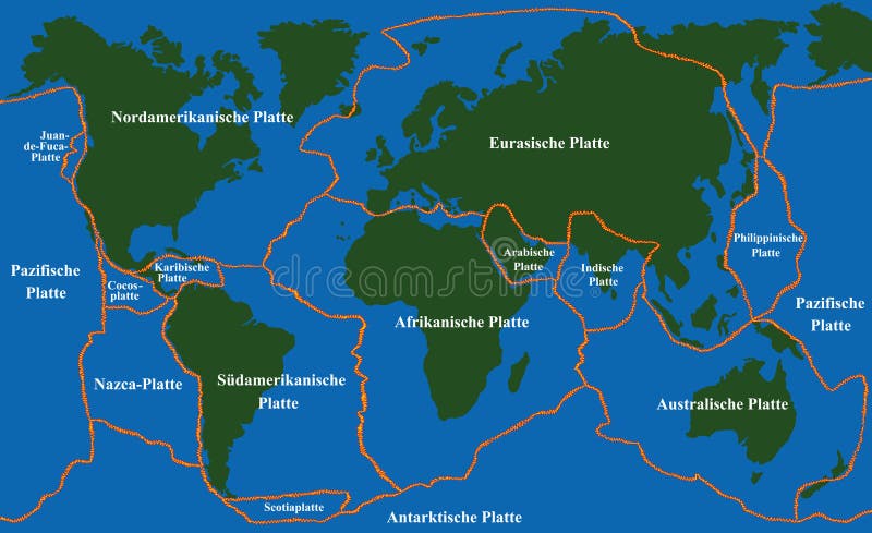
Free with trial Plate tectonics - world map with fault lines of major an minor plates. GERMAN LABELING! Vector illustration. Nazca plate vectors Plate Tectonics Faultlines German. Plate tectonics - world map with fault lines of major an minor plates. GERMAN LABELING! Vector illustration.
Free with trial Tectonic plate earth map. Continental ocean pacific, volcano lithosphere geography plates. Nazca plate vectors Tectonic plate earth map. Continental ocean pacific, volcano lithosphere geography plates
Free with trial Tectonic plate earth map. Continental ocean pacific, volcano lithosphere geography plates. Nazca plate vectors Tectonic plate earth map. Continental ocean pacific, volcano lithosphere geography plates
Free with trial Outline of the Nazca tectonic plate with the borders of surrounding plates against the background of a relief map. 3D rendering. Nazca plate illustrations Nazca tectonic plate - outlined. Relief. Outline of the Nazca tectonic plate with the borders of surrounding plates against the background of a relief map. 3D rendering
Free with trial Shape of the Nazca tectonic plate on the Blue Marble satellite map in the Patterson Cylindrical (oblique) projection. Nazca plate illustrations Nazca tectonic plate. Satellite map. Shape of the Nazca tectonic plate on the Blue Marble satellite map in the Patterson Cylindrical (oblique) projection
Free with trial Tectonic plate boundaries adjacent to the Nazca tectonic plate on the solid contour map in the Patterson Cylindrical (oblique) projection. Nazca plate illustrations Near Nazca plate. Boundaries. Contour map. Tectonic plate boundaries adjacent to the Nazca tectonic plate on the solid contour map in the Patterson Cylindrical (oblique) projection
Free with trial Tectonic plates borders of areas adjacent to the Nazca plate area on the satellite map in the Fahey projection. Nazca plate illustrations Nazca plate - neighborhoods. Fahey. Satellite. Tectonic plates borders of areas adjacent to the Nazca plate area on the satellite map in the Fahey projection
Free with trial Nazca tectonic plate on the physical elevation map in the Gall Stereographic projection centered meridionally. Locations of earthquakes above 6. 5 magnitude recorded since the early 17th century. Nazca plate illustrations Nazca tectonic plate. Physical. Gall Stereographic. Earthquakes. Nazca tectonic plate on the physical elevation map in the Gall Stereographic projection centered meridionally. Locations of earthquakes above 6.5 magnitude recorded since the early 17th century
Free with trial Outline of the Nazca tectonic plate with the borders of surrounding plates against the background of a satellite map. 3D rendering. Nazca plate illustrations Nazca tectonic plate - outlined. Satellite. Outline of the Nazca tectonic plate with the borders of surrounding plates against the background of a satellite map. 3D rendering
Free with trial Plate tectonics - planet earth with major an minor plates - GERMAN LABELING! Vector illustration. Nazca plate vectors Plate Tectonics German. Plate tectonics - planet earth with major an minor plates - GERMAN LABELING! Vector illustration.
Free with trial Tectonic plate earth map. Continental ocean pacific, volcano lithosphere geography plates. Nazca plate vectors Tectonic plate earth map. Continental ocean pacific, volcano lithosphere geography plates
Free with trial Plate tectonics on the planet Earth. Pangaea. Continental drift. Supercontinent at 250 Ma. Era of the dinosaurs. Jurassic period. Mesozoic. Hand drawn sketch for typography. Vintage engraving style. Nazca plate vectors Plate tectonics on the planet Earth. Pangaea. Continental drift. Supercontinent at 250 Ma. Era of the dinosaurs
Free with trial Plate tectonics on the planet Earth. Pangaea. Continental drift. Supercontinent at 250 Ma. Era of the dinosaurs. Jurassic period. Mesozoic. Hand drawn sketch for typography. Vintage engraving style. Nazca plate vectors Plate tectonics on the planet Earth. Pangaea. Continental drift. Supercontinent at 250 Ma. Era of the dinosaurs
Free with trial Peru car license plate, letters, numbers and symbols, vector illustration, south america. Nazca plate vectors Peru car license plate, letters, numbers and symbols, illustration. Peru car license plate, letters, numbers and symbols, vector illustration, south america
Free with trial Area of the Nazca tectonic plate marked with a dashed line on a satellite imagery map in the Eckert III projection. Nazca plate illustrations Nazca plate dashed. Eckert III. Satellite. Area of the Nazca tectonic plate marked with a dashed line on a satellite imagery map in the Eckert III projection
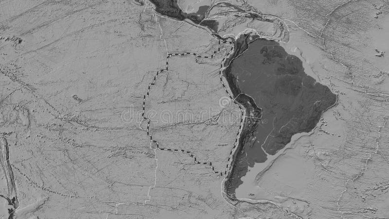
Free with trial Area of the Nazca tectonic plate marked with a dashed line on a grayscale elevation map in the Eckert III projection. Nazca plate illustrations Nazca plate dashed. Eckert III. Grayscale. Area of the Nazca tectonic plate marked with a dashed line on a grayscale elevation map in the Eckert III projection
Free with trial Area of the Nazca tectonic plate marked with a solid line on a satellite imagery map in the Eckert III projection. Nazca plate illustrations Nazca plate outlined. Eckert III. Satellite. Area of the Nazca tectonic plate marked with a solid line on a satellite imagery map in the Eckert III projection
Free with trial Area of the Nazca tectonic plate outlined and extracted from a global satellite imagery map in the Eckert III projection. Nazca plate illustrations Nazca plate extracted. Eckert III. Satellite. Area of the Nazca tectonic plate outlined and extracted from a global satellite imagery map in the Eckert III projection
Free with trial Satellite imagery map of the world in the Eckert III projection transformed to the center of the Nazca tectonic plate. Nazca plate illustrations Nazca plate - global map. Eckert III. Satellite. Satellite imagery map of the world in the Eckert III projection transformed to the center of the Nazca tectonic. Satellite imagery map of the world in the Eckert III projection transformed to the center of the Nazca tectonic plate
Free with trial Area of the Nazca tectonic plate marked with a dashed line against the background of a darkened satellite imagery map in the Eckert III projection. Nazca plate illustrations Nazca plate highlighted. Eckert III. Satellite. Area of the Nazca tectonic plate marked with a dashed line against the background of a darkened satellite imagery map in the Eckert III projection
Free with trial Tectonic plates borders of areas adjacent to the Nazca plate area on the satellite map in the Eckert III projection. Nazca plate illustrations Nazca plate - neighborhoods. Eckert III. Satellite. Tectonic plates borders of areas adjacent to the Nazca plate area on the satellite map in the Eckert III projection
Free with trial Area of the Nazca tectonic plate marked with a solid line on a grayscale elevation map in the Eckert III projection. Nazca plate illustrations Nazca plate outlined. Eckert III. Grayscale. Area of the Nazca tectonic plate marked with a solid line on a grayscale elevation map in the Eckert III projection
Free with trial Area of the Nazca tectonic plate outlined and extracted from a global grayscale elevation map in the Eckert III projection. Nazca plate illustrations Nazca plate extracted. Eckert III. Grayscale. Area of the Nazca tectonic plate outlined and extracted from a global grayscale elevation map in the Eckert III projection
Free with trial Grayscale elevation map of the world in the Eckert III projection transformed to the center of the Nazca tectonic plate. Nazca plate illustrations Nazca plate - global map. Eckert III. Grayscale. Grayscale elevation map of the world in the Eckert III projection transformed to the center of the Nazca tectonic plate
Free with trial Area of the Nazca tectonic plate marked with a dashed line against the background of a darkened grayscale elevation map in the Eckert III projection. Nazca plate illustrations Nazca plate highlighted. Eckert III. Grayscale. Area of the Nazca tectonic plate marked with a dashed line against the background of a darkened grayscale elevation map in the Eckert III projection
Free with trial Tectonic plates borders of areas adjacent to the Nazca plate area on the grayscale map in the Eckert III projection. Nazca plate illustrations Nazca plate - neighborhoods. Eckert III. Grayscale. Tectonic plates borders of areas adjacent to the Nazca plate area on the grayscale map in the Eckert III projection
Free with trial Nazca tectonic plate marked with a dashed line on a satellite imagery map in the Fahey projection. Nazca plate illustrations Nazca plate dashed. Fahey. Satellite. Nazca tectonic plate marked with a dashed line on a satellite imagery map in the Fahey projection
Free with trial Nazca tectonic plate marked with a solid line on a satellite imagery map in the Fahey projection. Nazca plate illustrations Nazca plate outlined. Fahey. Satellite. Nazca tectonic plate marked with a solid line on a satellite imagery map in the Fahey projection
Free with trial Nazca tectonic plate marked with a dashed line on a bilevel elevation map in the Eckert III projection. Nazca plate illustrations Nazca plate dashed. Eckert III. Bilevel. Nazca tectonic plate marked with a dashed line on a bilevel elevation map in the Eckert III projection
Free with trial Nazca tectonic plate outlined and extracted from a global satellite imagery map in the Fahey projection. Nazca plate illustrations Nazca plate extracted. Fahey. Satellite. Nazca tectonic plate outlined and extracted from a global satellite imagery map in the Fahey projection
Free with trial Satellite imagery map of the world in the Fahey projection transformed to the center of the Nazca tectonic plate. Nazca plate illustrations Nazca plate - global map. Fahey. Satellite. Satellite imagery map of the world in the Fahey projection transformed to the center of the Nazca tectonic plate
Free with trial Nazca tectonic plate marked with a dashed line against the background of a darkened satellite imagery map in the Fahey projection. Nazca plate illustrations Nazca plate highlighted. Fahey. Satellite. Nazca tectonic plate marked with a dashed line against the background of a darkened satellite imagery map in the Fahey projection
Free with trial Nazca tectonic plate marked with a solid line on a bilevel elevation map in the Eckert III projection. Nazca plate illustrations Nazca plate outlined. Eckert III. Bilevel. Nazca tectonic plate marked with a solid line on a bilevel elevation map in the Eckert III projection
Free with trial Nazca tectonic plate outlined and extracted from a global bilevel elevation map in the Eckert III projection. Nazca plate illustrations Nazca plate extracted. Eckert III. Bilevel. Nazca tectonic plate outlined and extracted from a global bilevel elevation map in the Eckert III projection
Free with trial Bilevel elevation map of the world in the Eckert III projection transformed to the center of the Nazca tectonic plate. Nazca plate illustrations Nazca plate - global map. Eckert III. Bilevel. Bilevel elevation map of the world in the Eckert III projection transformed to the center of the Nazca tectonic plate
Free with trial Nazca tectonic plate marked with a dashed line against the background of a darkened bilevel elevation map in the Eckert III projection. Nazca plate illustrations Nazca plate highlighted. Eckert III. Bilevel. Nazca tectonic plate marked with a dashed line against the background of a darkened bilevel elevation map in the Eckert III projection
Free with trial Tectonic plates borders of areas adjacent to the Nazca plate area on the bilevel map in the Eckert III projection. Nazca plate illustrations Nazca plate - neighborhoods. Eckert III. Bilevel. Tectonic plates borders of areas adjacent to the Nazca plate area on the bilevel map in the Eckert III projection
Free with trial Nazca tectonic plate on the Wiki style elevation map in the Patterson Cylindrical projection centered meridionally. Boundaries of other plates. Nazca plate illustrations Nazca tectonic plate. Wiki. Patterson Cylindrical. Boundaries. Nazca tectonic plate on the Wiki style elevation map in the Patterson Cylindrical projection centered meridionally. Boundaries of other plates
Free with trial Nazca tectonic plate on the solid contour map in the Patterson Cylindrical projection centered meridionally. Distribution of known volcanoes. Nazca plate illustrations Nazca tectonic plate. Contour. Patterson Cylindrical. Volcanoes. Nazca tectonic plate on the solid contour map in the Patterson Cylindrical projection centered meridionally. Distribution of known volcanoes
Free with trial Nazca tectonic plate on the grayscale elevation map in the Patterson Cylindrical projection centered meridionally. Boundaries of other plates. Nazca plate illustrations Nazca tectonic plate. Grayscale. Patterson Cylindrical. Boundari. Nazca tectonic plate on the grayscale elevation map in the Patterson Cylindrical projection centered meridionally. Boundaries of other plates
Free with trial Nazca tectonic plate on the physical elevation map in the Patterson Cylindrical projection centered meridionally. Locations of earthquakes above 6. 5 magnitude recorded since the early 17th century. Nazca plate illustrations Nazca tectonic plate. Physical. Patterson Cylindrical. Earthquak. Nazca tectonic plate on the physical elevation map in the Patterson Cylindrical projection centered meridionally. Locations of earthquakes above 6.5 magnitude recorded since the early 17th century
Free with trial Nazca tectonic plate on the solid contour map in the Patterson Cylindrical projection centered meridionally. Boundaries of other plates. Nazca plate illustrations Nazca tectonic plate. Contour. Patterson Cylindrical. Boundaries. Nazca tectonic plate on the solid contour map in the Patterson Cylindrical projection centered meridionally. Boundaries of other plates
Free with trial Nazca tectonic plate on the physical elevation map in the Patterson Cylindrical projection centered meridionally. Boundaries of other plates. Nazca plate illustrations Nazca tectonic plate. Physical. Patterson Cylindrical. Boundarie. Nazca tectonic plate on the physical elevation map in the Patterson Cylindrical projection centered meridionally. Boundaries of other plates
Free with trial Nazca tectonic plate on the solid contour map in the Patterson Cylindrical Oblique projection centered meridionally and latitudinally. Boundaries of other plates. Nazca plate illustrations Nazca tectonic plate. Contour. Patterson Cylindrical Oblique. Bo. Nazca tectonic plate on the solid contour map in the Patterson Cylindrical Oblique projection centered meridionally and latitudinally. Boundaries of other plates
Free with trial Nazca tectonic plate on the bilevel elevation map in the Patterson Cylindrical Oblique projection centered meridionally and latitudinally. Boundaries of other plates. Nazca plate illustrations Nazca tectonic plate. Bilevel. Patterson Cylindrical Oblique. Bo. Nazca tectonic plate on the bilevel elevation map in the Patterson Cylindrical Oblique projection centered meridionally and latitudinally. Boundaries of other plates
Free with trial Nazca tectonic plate on the physical elevation map in the Patterson Cylindrical Oblique projection centered meridionally and latitudinally. Boundaries of other plates. Nazca plate illustrations Nazca tectonic plate. Physical. Patterson Cylindrical Oblique. B. Nazca tectonic plate on the physical elevation map in the Patterson Cylindrical Oblique projection centered meridionally and latitudinally. Boundaries of other plates
Free with trial Nazca tectonic plate on the Wiki style elevation map in the Patterson Cylindrical Oblique projection centered meridionally and latitudinally. Distribution of known volcanoes. Nazca plate illustrations Nazca tectonic plate. Wiki. Patterson Cylindrical Oblique. Volca. Nazca tectonic plate on the Wiki style elevation map in the Patterson Cylindrical Oblique projection centered meridionally and latitudinally. Distribution of known volcanoes
Free with trial Nazca tectonic plate on the grayscale elevation map in the Patterson Cylindrical projection centered meridionally. Locations of earthquakes above 6. 5 magnitude recorded since the early 17th century. Nazca plate illustrations Nazca tectonic plate. Grayscale. Patterson Cylindrical. Earthqua. Nazca tectonic plate on the grayscale elevation map in the Patterson Cylindrical projection centered meridionally. Locations of earthquakes above 6.5 magnitude recorded since the early 17th century
Free with trial Nazca tectonic plate on the solid contour map in the Patterson Cylindrical Oblique projection centered meridionally and latitudinally. Locations of earthquakes above 6. 5 magnitude recorded since the early 17th century. Nazca plate illustrations Nazca tectonic plate. Contour. Patterson Cylindrical Oblique. Ea. Nazca tectonic plate on the solid contour map in the Patterson Cylindrical Oblique projection centered meridionally and latitudinally. Locations of earthquakes above 6.5 magnitude recorded since the early 17th century
Free with trial Nazca tectonic plate on the physical elevation map in the Patterson Cylindrical projection centered meridionally. Distribution of known volcanoes. Nazca plate illustrations Nazca tectonic plate. Physical. Patterson Cylindrical. Volcanoes. Nazca tectonic plate on the physical elevation map in the Patterson Cylindrical projection centered meridionally. Distribution of known volcanoes
Free with trial Nazca tectonic plate on the bilevel elevation map in the Patterson Cylindrical Oblique projection centered meridionally and latitudinally. Locations of earthquakes above 6. 5 magnitude recorded since the early 17th century. Nazca plate illustrations Nazca tectonic plate. Bilevel. Patterson Cylindrical Oblique. Ea. Nazca tectonic plate on the bilevel elevation map in the Patterson Cylindrical Oblique projection centered meridionally and latitudinally. Locations of earthquakes above 6.5 magnitude recorded since the early 17th century
Free with trial Nazca tectonic plate on the Blue Marble satellite map in the Patterson Cylindrical projection centered meridionally. Locations of earthquakes above 6. 5 magnitude recorded since the early 17th century. Nazca plate illustrations Nazca tectonic plate. Satellite. Patterson Cylindrical. Earthqua. Nazca tectonic plate on the Blue Marble satellite map in the Patterson Cylindrical projection centered meridionally. Locations of earthquakes above 6.5 magnitude recorded since the early 17th century
Free with trial Nazca tectonic plate on the Wiki style elevation map in the Patterson Cylindrical projection centered meridionally. Locations of earthquakes above 6. 5 magnitude recorded since the early 17th century. Nazca plate illustrations Nazca tectonic plate. Wiki. Patterson Cylindrical. Earthquakes a. Nazca tectonic plate on the Wiki style elevation map in the Patterson Cylindrical projection centered meridionally. Locations of earthquakes above 6.5 magnitude recorded since the early 17th century
Free with trial Nazca tectonic plate on the solid contour map in the Patterson Cylindrical Oblique projection centered meridionally and latitudinally. Distribution of known volcanoes. Nazca plate illustrations Nazca tectonic plate. Contour. Patterson Cylindrical Oblique. Vo. Nazca tectonic plate on the solid contour map in the Patterson Cylindrical Oblique projection centered meridionally and latitudinally. Distribution of known volcanoes
Free with trial Nazca tectonic plate on the bilevel elevation map in the Patterson Cylindrical projection centered meridionally. Boundaries of other plates. Nazca plate illustrations Nazca tectonic plate. Bilevel. Patterson Cylindrical. Boundaries. Nazca tectonic plate on the bilevel elevation map in the Patterson Cylindrical projection centered meridionally. Boundaries of other plates
Free with trial Nazca tectonic plate on the Wiki style elevation map in the Patterson Cylindrical Oblique projection centered meridionally and latitudinally. Boundaries of other plates. Nazca plate illustrations Nazca tectonic plate. Wiki. Patterson Cylindrical Oblique. Bound. Nazca tectonic plate on the Wiki style elevation map in the Patterson Cylindrical Oblique projection centered meridionally and latitudinally. Boundaries of other plates
Free with trial Nazca tectonic plate on the Blue Marble satellite map in the Patterson Cylindrical projection centered meridionally. Distribution of known volcanoes. Nazca plate illustrations Nazca tectonic plate. Satellite. Patterson Cylindrical. Volcanoe. Nazca tectonic plate on the Blue Marble satellite map in the Patterson Cylindrical projection centered meridionally. Distribution of known volcanoes
Free with trial Nazca tectonic plate on the Wiki style elevation map in the Patterson Cylindrical Oblique projection centered meridionally and latitudinally. Locations of earthquakes above 6. 5 magnitude recorded since the early 17th century. Nazca plate illustrations Nazca tectonic plate. Wiki. Patterson Cylindrical Oblique. Earth. Nazca tectonic plate on the Wiki style elevation map in the Patterson Cylindrical Oblique projection centered meridionally and latitudinally. Locations of earthquakes above 6.5 magnitude recorded since the early 17th century
Free with trial Nazca tectonic plate on the Blue Marble satellite map in the Patterson Cylindrical projection centered meridionally. Boundaries of other plates. Nazca plate illustrations Nazca tectonic plate. Satellite. Patterson Cylindrical. Boundari. Nazca tectonic plate on the Blue Marble satellite map in the Patterson Cylindrical projection centered meridionally. Boundaries of other plates
Free with trial Nazca tectonic plate on the solid contour map in the Patterson Cylindrical projection centered meridionally. Locations of earthquakes above 6. 5 magnitude recorded since the early 17th century. Nazca plate illustrations Nazca tectonic plate. Contour. Patterson Cylindrical. Earthquake. Nazca tectonic plate on the solid contour map in the Patterson Cylindrical projection centered meridionally. Locations of earthquakes above 6.5 magnitude recorded since the early 17th century
Free with trial Nazca tectonic plate on the physical elevation map in the Patterson Cylindrical Oblique projection centered meridionally and latitudinally. Locations of earthquakes above 6. 5 magnitude recorded since the early 17th century. Nazca plate illustrations Nazca tectonic plate. Physical. Patterson Cylindrical Oblique. E. Nazca tectonic plate on the physical elevation map in the Patterson Cylindrical Oblique projection centered meridionally and latitudinally. Locations of earthquakes above 6.5 magnitude recorded since the early 17th century
Free with trial Nazca tectonic plate on the Wiki style elevation map in the Patterson Cylindrical projection centered meridionally. Distribution of known volcanoes. Nazca plate illustrations Nazca tectonic plate. Wiki. Patterson Cylindrical. Volcanoes and. Nazca tectonic plate on the Wiki style elevation map in the Patterson Cylindrical projection centered meridionally. Distribution of known volcanoes
Free with trial Nazca tectonic plate on the physical elevation map in the Patterson Cylindrical Oblique projection centered meridionally and latitudinally. Distribution of known volcanoes. Nazca plate illustrations Nazca tectonic plate. Physical. Patterson Cylindrical Oblique. V. Nazca tectonic plate on the physical elevation map in the Patterson Cylindrical Oblique projection centered meridionally and latitudinally. Distribution of known volcanoes
Free with trial Nazca tectonic plate on the bilevel elevation map in the Patterson Cylindrical projection centered meridionally. Locations of earthquakes above 6. 5 magnitude recorded since the early 17th century. Nazca plate illustrations Nazca tectonic plate. Bilevel. Patterson Cylindrical. Earthquake. Nazca tectonic plate on the bilevel elevation map in the Patterson Cylindrical projection centered meridionally. Locations of earthquakes above 6.5 magnitude recorded since the early 17th century
Free with trial Nazca tectonic plate on the bilevel elevation map in the Patterson Cylindrical Oblique projection centered meridionally and latitudinally. Nazca plate illustrations Nazca tectonic plate. Bilevel. Patterson Cylindrical Oblique. Nazca tectonic plate on the bilevel elevation map in the Patterson Cylindrical Oblique projection centered meridionally and latitudinally.
Free with trial Nazca tectonic plate on the grayscale elevation map in the Patterson Cylindrical Oblique projection centered meridionally and latitudinally. Boundaries of other plates. Nazca plate illustrations Nazca tectonic plate. Grayscale. Patterson Cylindrical Oblique. Nazca tectonic plate on the grayscale elevation map in the Patterson Cylindrical Oblique projection centered meridionally and latitudinally. Boundaries of other plates
Free with trial Nazca tectonic plate on the grayscale elevation map in the Patterson Cylindrical Oblique projection centered meridionally and latitudinally. Nazca plate illustrations Nazca tectonic plate. Grayscale. Patterson Cylindrical Oblique. Nazca tectonic plate on the grayscale elevation map in the Patterson Cylindrical Oblique projection centered meridionally and latitudinally.
Free with trial Nazca tectonic plate on the Wiki style elevation map in the Patterson Cylindrical projection centered meridionally. Nazca plate illustrations Nazca tectonic plate. Wiki. Patterson Cylindrical. Nazca tectonic plate on the Wiki style elevation map in the Patterson Cylindrical projection centered meridionally.
Free with trial Nazca tectonic plate on the grayscale elevation map in the Patterson Cylindrical Oblique projection centered meridionally and latitudinally. Locations of earthquakes above 6. 5 magnitude recorded since the early 17th century. Nazca plate illustrations Nazca tectonic plate. Grayscale. Patterson Cylindrical Oblique. Nazca tectonic plate on the grayscale elevation map in the Patterson Cylindrical Oblique projection centered meridionally and latitudinally. Locations of earthquakes above 6.5 magnitude recorded since the early 17th century
Free with trial This comprehensive tectonic map showcases the intricate dynamics of the Nazca Plate, a crucial component of South America's geological landscape. The map provides a detailed visualization of the plate's boundaries, its interaction with the South American Plate, and the resulting geological processes. Observe the intricate patterns of convergent and divergent plate boundaries, highlighting areas. Nazca plate illustrations Understanding South Americas Dynamic Geology A Detailed Tectonic Map of the Nazca Plate. This comprehensive tectonic map showcases the intricate dynamics of the Nazca Plate, a crucial component of South America's geological landscape. The map provides a detailed visualization of the plate's boundaries, its interaction with the South American Plate, and the resulting geological processes. Observe the intricate patterns of convergent and divergent plate boundaries, highlighting areas
Free with trial Nazca tectonic plate on the bilevel elevation map in the Patterson Cylindrical projection centered meridionally. Nazca plate illustrations Nazca tectonic plate. Bilevel. Patterson Cylindrical. Nazca tectonic plate on the bilevel elevation map in the Patterson Cylindrical projection centered meridionally.
Free with trial Nazca tectonic plate on the solid contour map in the Patterson Cylindrical projection centered meridionally. Nazca plate illustrations Nazca tectonic plate. Contour. Patterson Cylindrical. Nazca tectonic plate on the solid contour map in the Patterson Cylindrical projection centered meridionally.
Free with trial Nazca tectonic plate on the physical elevation map in the Patterson Cylindrical projection centered meridionally. Nazca plate illustrations Nazca tectonic plate. Physical. Patterson Cylindrical. Nazca tectonic plate on the physical elevation map in the Patterson Cylindrical projection centered meridionally.
Free with trial Nazca tectonic plate on the Blue Marble satellite map in the Patterson Cylindrical projection centered meridionally. Nazca plate illustrations Nazca tectonic plate. Satellite. Patterson Cylindrical. Nazca tectonic plate on the Blue Marble satellite map in the Patterson Cylindrical projection centered meridionally.
Free with trial Nazca tectonic plate on the grayscale elevation map in the Patterson Cylindrical projection centered meridionally. Nazca plate illustrations Nazca tectonic plate. Grayscale. Patterson Cylindrical. Nazca tectonic plate on the grayscale elevation map in the Patterson Cylindrical projection centered meridionally.
Free with trial Nazca tectonic plate on the Wiki style elevation map in the Patterson Cylindrical Oblique projection centered meridionally and latitudinally. Nazca plate illustrations Nazca tectonic plate. Wiki. Patterson Cylindrical Oblique. Nazca tectonic plate on the Wiki style elevation map in the Patterson Cylindrical Oblique projection centered meridionally and latitudinally.