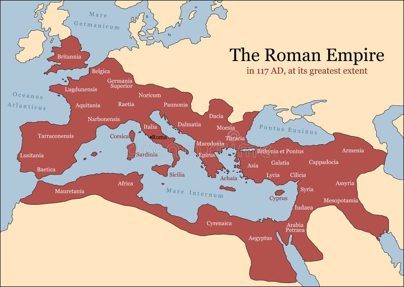
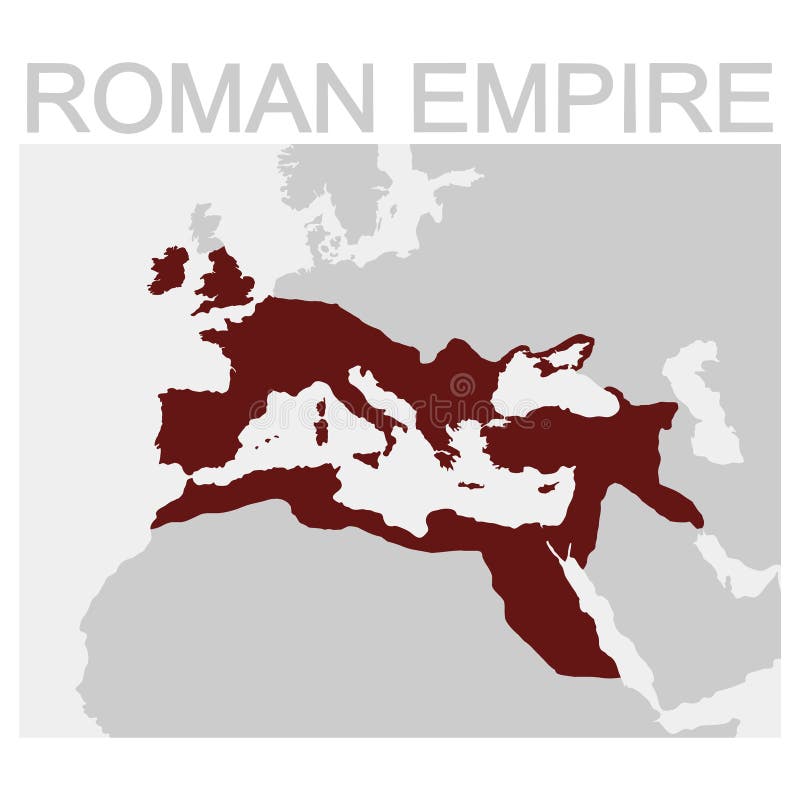
Free with trial The Roman Empire at its greatest extent in 117 AD at the time of Trajan, plus principal provinces. Vector illustration. Roman empire map vectors Roman Empire Provinces. The Roman Empire at its greatest extent in 117 AD at the time of Trajan, plus principal provinces. Vector illustration.
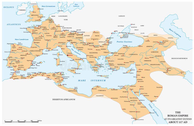
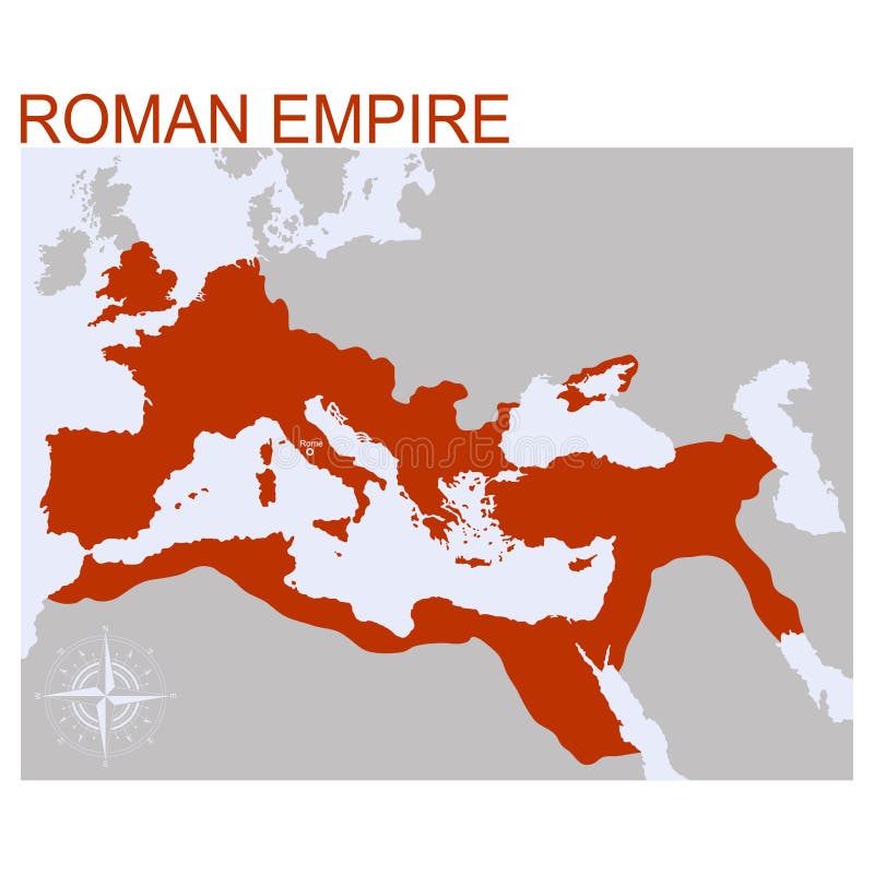
Free with trial The Roman Empire at its maximum expansion in 117 AD. Roman empire map vectors The Roman Empire at its maximum expansion in 117 AD
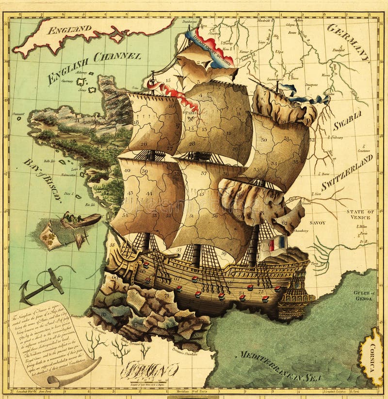
Free with trial Antique Map of Ancient France. Roman empire map illustrations Ancient map. Antique Map of Ancient France
Free with trial Some pictograms representing Italy and its traditions,. Roman empire map vectors Italy pictograms. Some pictograms representing Italy and its traditions,
Free with trial Great antique Rome - artwork in retro style series. Roman empire map illustrations Rome, architecture. Great antique Rome - artwork in retro style series
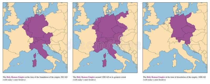
Free with trial Holy Roman Empire - rise and fall of the medieval europe empire from 962 AD to 1806 AD - with todays state borders. Vector illustration. Roman empire map vectors Holy Roman Empire History Map Rise And Fall. Holy Roman Empire - rise and fall of the medieval europe empire from 962 AD to 1806 AD - with todays state borders. Vector illustration.
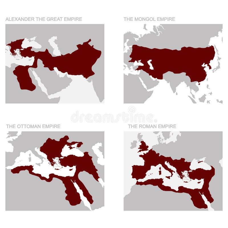
Free with trial Maps representing four different moments of territorial domain of the Roman Empire on Europe and North Africa. Roman empire map illustrations Expansion of Roman Empire before and after Christ. Maps representing four different moments of territorial domain of the Roman Empire on Europe and North Africa
Free with trial Ancient Rome Tiles for Online Strategic Game Insight and Development. Isometric Flat 3D Roman Imperial Buildings. Explore Game Phenomena of Rome Caesar Age Atmosphere. Roman empire map vectors Roman 01 Tiles Isometric. Ancient Rome Tiles for Online Strategic Game Insight and Development. Isometric Flat 3D Roman Imperial Buildings. Explore Game Phenomena of Rome Caesar Age Atmosphere
Free with trial Ancient Rome Tiles for Online Strategic Game Insight and Development. Isometric Flat 3D Roman Imperial Buildings. Explore Game Phenomena of Rome Caesar Age Atmosphere. Roman empire map vectors Roman 02 Tiles Isometric. Ancient Rome Tiles for Online Strategic Game Insight and Development. Isometric Flat 3D Roman Imperial Buildings. Explore Game Phenomena of Rome Caesar Age Atmosphere
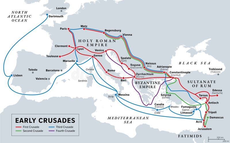
Free with trial Early Crusades, history map. The first four Crusades, a series of religious wars to the Holy Land, to conquer Jerusalem and its surrounding area, by the Christian Latin Church in the medieval period. Roman empire map vectors Early Crusades, history map of the first four Crusades to the Holy Land. Early Crusades, history map. The first four Crusades, a series of religious wars to the Holy Land, to conquer Jerusalem and its surrounding area, by the Christian Latin Church in the medieval period.
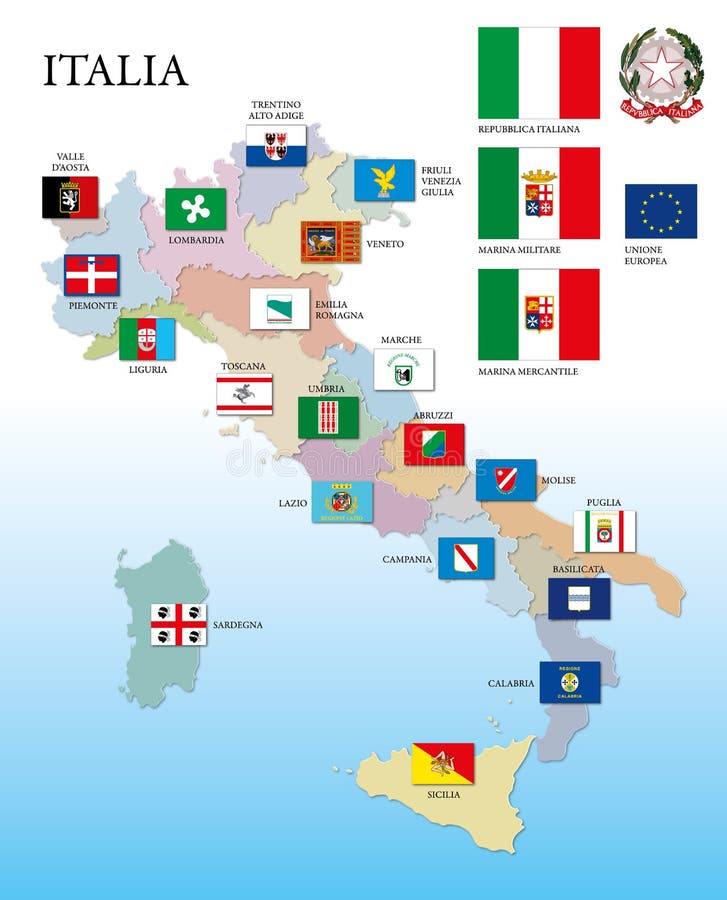
Free with trial Italy, regional flags and map, vector illustration. Roman empire map vectors Italy, regional flags and map
Free with trial Ancient Rome Tiles for Online Strategic Game Insight and Development. Isometric Flat 3D Roman Imperial Buildings. Explore Game Phenomena of Rome Caesar Age Atmosphere. Roman empire map vectors Roman 04 Tiles Isometric. Ancient Rome Tiles for Online Strategic Game Insight and Development. Isometric Flat 3D Roman Imperial Buildings. Explore Game Phenomena of Rome Caesar Age Atmosphere
Free with trial Illustration of map of Ancient Byzantium. Roman empire map vectors Map of Ancient Byzantium
Free with trial Some pictograms representing Italy and its traditions,. Roman empire map vectors Italy pictograms. Some pictograms representing Italy and its traditions,
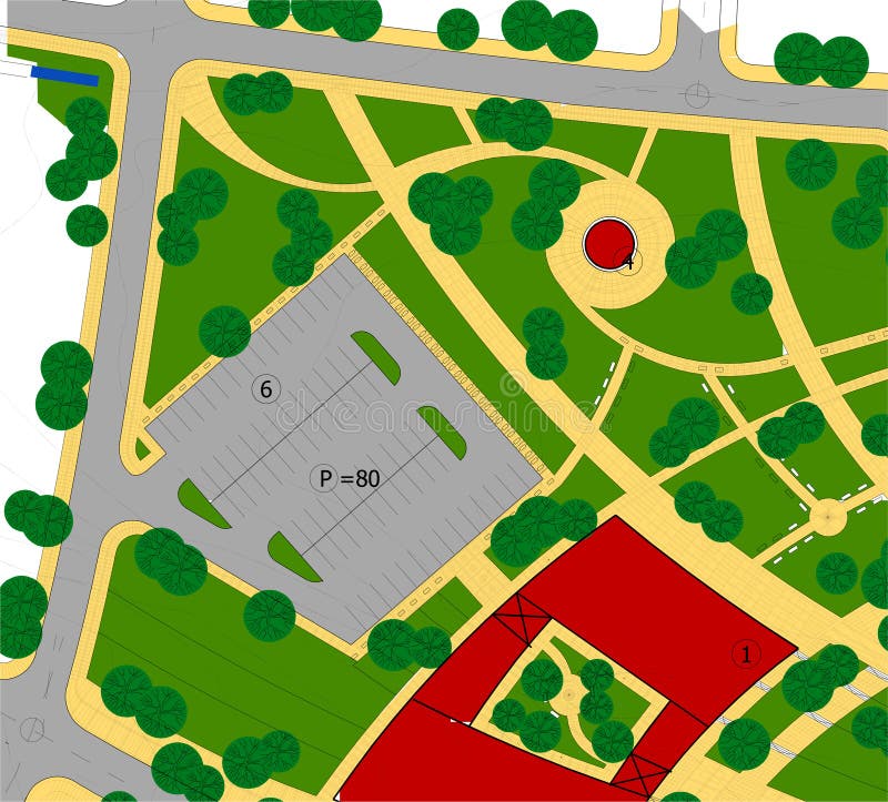
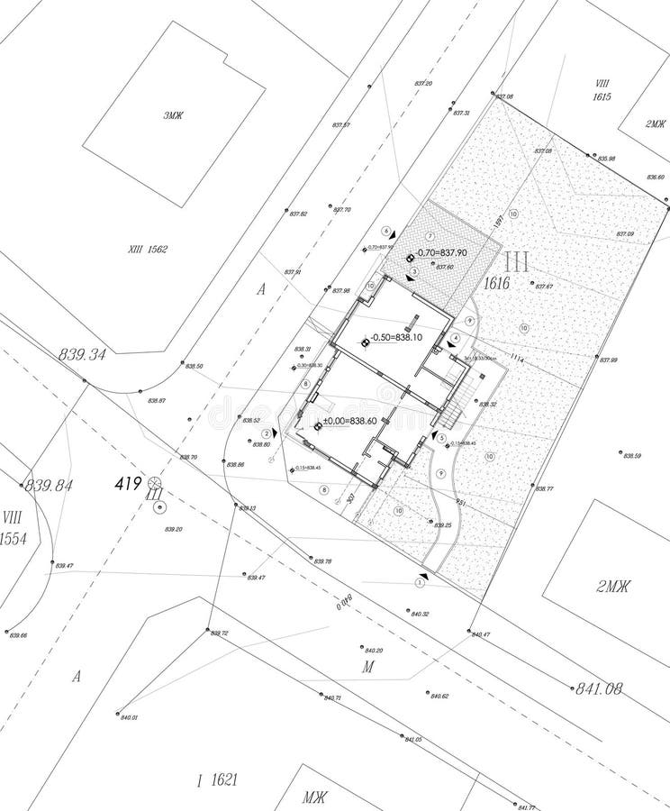
Free with trial Cadastre drawing - close up view. Roman empire map illustrations Urban plan drawing. Cadastre drawing - close up view
Free with trial Invasions of the Roman Empire, historical map. Migration Period, or also the Barbarian Invasions, from 300 to 600 AD. A period in European history marked by large-scale migrations by various tribes. Roman empire map vectors Invasions of the Roman Empire, historical map of the Migration Period. Invasions of the Roman Empire, historical map. Migration Period, or also the Barbarian Invasions, from 300 to 600 AD. A period in European history marked by large-scale migrations by various tribes.
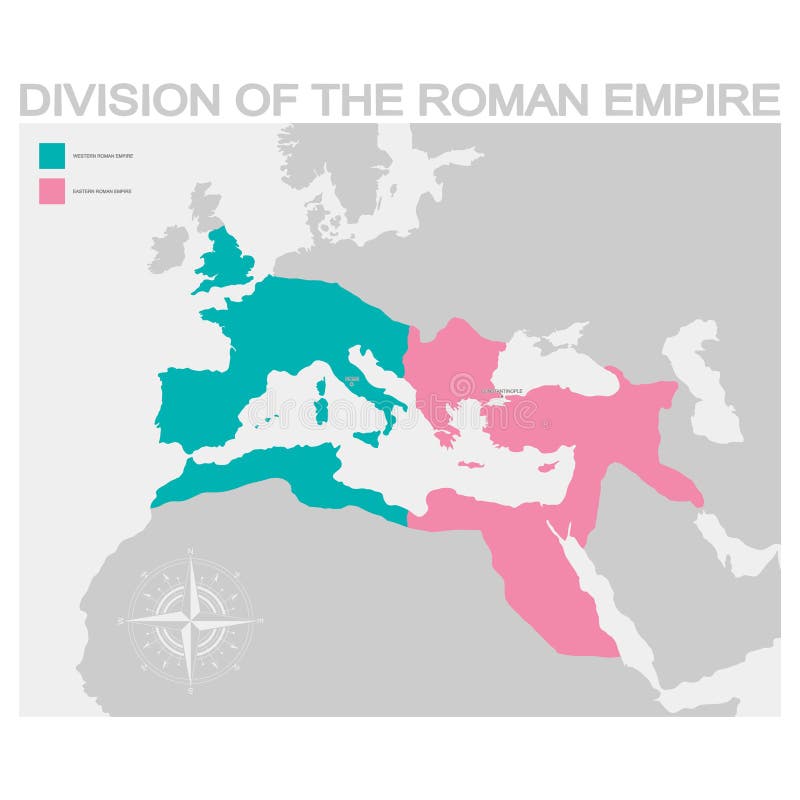
Free with trial Vector map of the Division of the Roman Empire. Roman empire map vectors Map of the Division of the Roman Empire
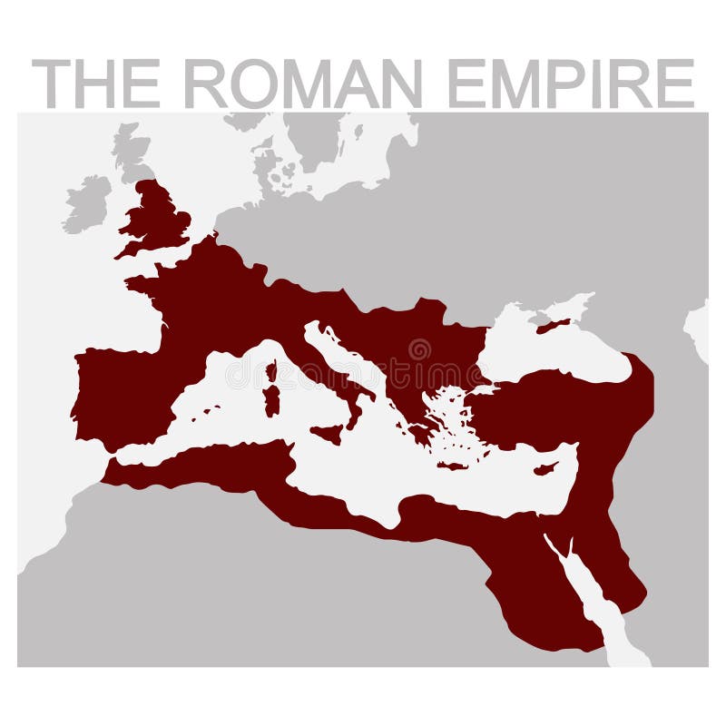
Free with trial Vector map of the Roman Empire for your design. Roman empire map vectors Vector map of the Roman Empire
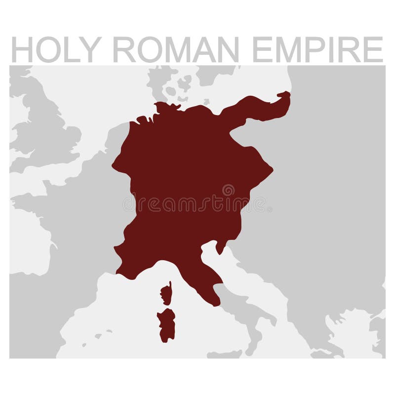
Free with trial Vector map of the Holy Roman Empire. Roman empire map vectors Map of the Holy Roman Empire
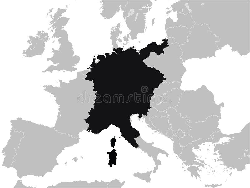
Free with trial Black Flat Map of Holy Roman Empire inside Gray Map of Europe. Roman empire map vectors Map of Holy Roman Empire
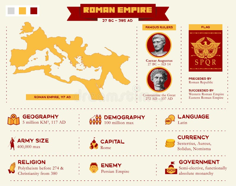
Free with trial Roman Empire infographic presentation with map and icon of geography, demography, language, army, military, capital, currency, religion, enemy and government. Vector illustration template concept. Roman empire map vectors Roman Empire infographic presentation with map and icon
Free with trial Ancient map of Constantinople city from rare book by Cristoforo Buondelmonti printed in 1475. Old paper page with image of Constantinople, capital of Roman Byzantine Empire. History concept. Roman empire map illustrations Ancient map of Constantinople city from rare book by Cristoforo Buondelmonti printed in 1475
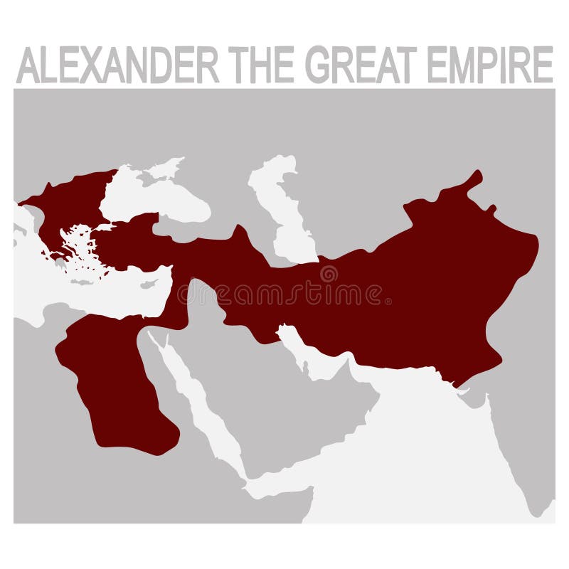
Free with trial Vector map of the alexander the great empire. Roman empire map vectors Map of the alexander the great empire
Free with trial Vector map of the Byzantine Empire for your design. Roman empire map vectors Vector map of the Byzantine Empire
Free with trial Black Flat Map of Angevin Empire year 1190 inside Gray Map of European Continent. Roman empire map vectors Map of Angevin Empire year 1190
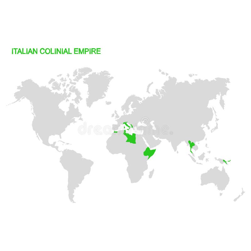
Free with trial Vector world map with Italian colonial empire. Roman empire map vectors World map with Italian colonial empire. Vector world map with Italian colonial empire
Free with trial The Ancient Roman Forum in Rome, Italy, is a magnificent archaeological site showcasing the ruins of grand temples, basilicas, and arches that were once the center of political, commercial, and social life in the Roman Empire. Highlights include the Via Sacra, Temple of Caesar, Senate House, and Arch of Titus, providing a fascinating glimpse into ancient Roman history and architecture. Roman empire map illustrations Generative AI, Ancient Roman Forum ruins, Italy. The Ancient Roman Forum in Rome, Italy, is a magnificent archaeological site showcasing the ruins of grand temples, basilicas, and arches that were once the center of political, commercial, and social life in the Roman Empire. Highlights include the Via Sacra, Temple of Caesar, Senate House, and Arch of Titus, providing a fascinating glimpse into ancient Roman history and architecture
Free with trial Early Crusades, gray history map. First four Crusades, a series of religious wars to the Holy Land, to conquer Jerusalem and its surrounding area by the Christian Latin Church in the medieval period. Roman empire map vectors Early Crusades, gray history map of the first Crusades to Holy Land. Early Crusades, gray history map. First four Crusades, a series of religious wars to the Holy Land, to conquer Jerusalem and its surrounding area by the Christian Latin Church in the medieval period.
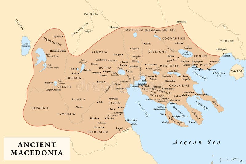
Free with trial Ancient Macedonia, Macedon, history map with approximate boundaries before Roman conquest. Kingdom on periphery of Archaic and Classical Greece which later become dominant state of Hellenistic Greece. Roman empire map vectors Ancient Macedonia, Macedon, history map
Free with trial Antique Map of Ancient France. Roman empire map illustrations Ancient map. Antique Map of Ancient France
Free with trial Ancient the Roma Empire territory maps, the Roma Empire development. Roman empire map illustrations The Roma Empire maps. Ancient the Roma Empire territory maps, the Roma Empire development
Free with trial Vector map of the Ancient Empires. Roman empire map vectors Map of the Ancient Empires
Free with trial Black Flat Map of Weimar Republic 1918–1933 inside Gray Map of Europe. Roman empire map vectors Map of Weimar Republic
Free with trial Black Flat Map of Kingdom of Italy year 1861 inside Gray Map of European Continent. Roman empire map vectors Map of Kingdom of Italy year 1861
Free with trial Black Flat Map of Map of Nazi Germany Third Reich 1933–1945 inside Gray Map of Europe. Roman empire map vectors Map of Nazi Germany Third Reich
Free with trial Black Flat Map of Kingdom of Portugal year 1190 inside Gray Map of European Continent. Roman empire map vectors Map of Kingdom of Portugal year 1190
Free with trial Vector Illustration of the Flag of German Empire 1871–1918. Roman empire map vectors Flag of German Empire
Free with trial Ancient Rome Tiles for Online Strategic Game Insight and Development. Isometric Flat 3D Roman Imperial Buildings. Explore Game Phenomena of Rome Caesar Age Atmosphere. Roman empire map vectors Roman 03 Tiles Isometric. Ancient Rome Tiles for Online Strategic Game Insight and Development. Isometric Flat 3D Roman Imperial Buildings. Explore Game Phenomena of Rome Caesar Age Atmosphere
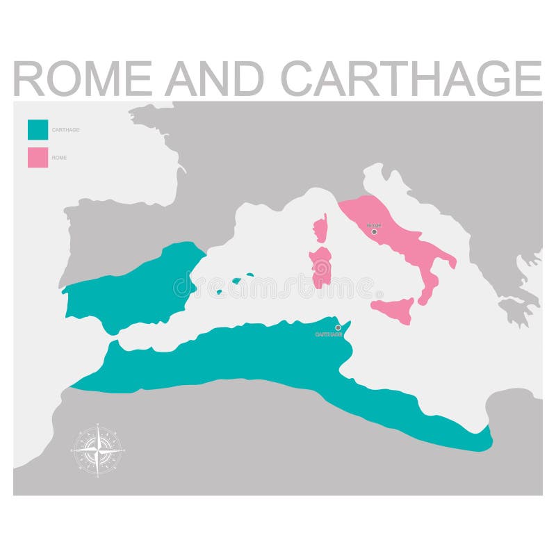
Free with trial Vector map of the Rome and Carthage territory. Roman empire map vectors Map of the Rome and Carthage territory
Free with trial The ancient Coliseum in Rome on background with Italy map. Roman empire map illustrations Italy set. The ancient Coliseum in Rome on background with Italy map
Free with trial Overview of relevant and touristic topics about Italy. Roman empire map illustrations Italy
Free with trial Cadastre drawing - close up view of a colored idea. Roman empire map illustrations Urban plan drawing. Cadastre drawing - close up view of a colored idea
Free with trial Cadastre drawing - close up view. Roman empire map illustrations Urban plan drawing. Cadastre drawing - close up view
Free with trial Cadastre drawing - close up view. Roman empire map illustrations Urban plan drawing. Cadastre drawing - close up view
Free with trial Vector isometric Pantheon illustration. Ancient Rome building icon. Gaming and infographic design. Roman empire map vectors Vector Ancient Isometric Illustration. Vector isometric Pantheon illustration. Ancient Rome building icon. Gaming and infographic design.
Free with trial Cadastre drawing - close up view of a colored idea. Roman empire map illustrations Urban plan drawing. Cadastre drawing - close up view of a colored idea
Free with trial Cadastre drawing - close up view. Roman empire map illustrations Urban plan drawing. Cadastre drawing - close up view
Free with trial Original elaboration italian flags. Roman empire map vectors I love italy flag. Original elaboration italian flags
Free with trial Vector Illustration of the Royal Arms of England. Roman empire map vectors Royal Arms of England
Free with trial Vector Illustration of the Flag of East Germany German Democratic Republic - GDR, 1949–1990. Roman empire map vectors Flag of East Germany German Democratic Republic - GDR
Free with trial Vintage-styled classroom featuring a history theme. An open "World History" book lies on a wooden desk, accompanied by a pair of glasses and a decorative wooden pointer. A chalkboard in the background displays a map of Europe and the Roman Empire, contributing to an academic setting. Large windows allow natural light to illuminate the room, highlighting the dust particles in the air, creating an antique atmosphere. The scene evokes a sense of historical study and traditional educational environments. Roman empire map illustrations In the background displays a map of Europe and the Roman Empire
Free with trial This old-world Roman Empire map depicts the Mediterranean basin surrounded by historically inspired territories rendered through isometric elevation and hand-drawn linework. Tiny triremes sail the seas, while forests, vineyards, fortified settlements, and desert caravans show regional diversity. An ornate Roman border and compass rose complete the composition on worn parchment with soft earth-tone patina, ideal for educational or decorative use. This image was AI-generated. Roman empire map illustrations Old world map of Roman Empire with decorative compass rose. This old-world Roman Empire map depicts the Mediterranean basin surrounded by historically inspired territories rendered through isometric elevation and hand-drawn linework. Tiny triremes sail the seas, while forests, vineyards, fortified settlements, and desert caravans show regional diversity. An ornate Roman border and compass rose complete the composition on worn parchment with soft earth-tone patina, ideal for educational or decorative use. This image was AI-generated.
Free with trial This detailed antique-style map presents the Roman Empire surrounding the Mediterranean Sea in a semi-isometric cartographic view. Stylized ink waves, miniature triremes, and elevated terrain highlight Italy, Greece, Egypt, and Western provinces through visual storytelling. Marble landmarks, amphitheaters, aqueducts, and roads enrich the historic feel, framed by a Roman-themed border with laurel motifs and compass rose. Aged parchment tones enhance authenticity. This image was AI-generated. Roman empire map illustrations Antique isometric map of Roman Empire around Mediterranean Sea. This detailed antique-style map presents the Roman Empire surrounding the Mediterranean Sea in a semi-isometric cartographic view. Stylized ink waves, miniature triremes, and elevated terrain highlight Italy, Greece, Egypt, and Western provinces through visual storytelling. Marble landmarks, amphitheaters, aqueducts, and roads enrich the historic feel, framed by a Roman-themed border with laurel motifs and compass rose. Aged parchment tones enhance authenticity. This image was AI-generated.
Free with trial This old-world style Roman Empire map presents the Mediterranean as a maritime hub, with symbolic terrain, villas, forts, harbors, aqueducts, and cultivated farmlands across surrounding territories. Sea lanes feature galleys and mythical creatures, while forests, vineyards, and desert routes showcase regional variety. A laurel and mosaic border frames the parchment surface with aged discoloration and timeless character. This image was AI-generated. Roman empire map illustrations Old-world Roman Empire map with mosaic border and sea creatures. This old-world style Roman Empire map presents the Mediterranean as a maritime hub, with symbolic terrain, villas, forts, harbors, aqueducts, and cultivated farmlands across surrounding territories. Sea lanes feature galleys and mythical creatures, while forests, vineyards, and desert routes showcase regional variety. A laurel and mosaic border frames the parchment surface with aged discoloration and timeless character. This image was AI-generated.
Free with trial This classical map illustration depicts the Roman Empire surrounding the Mediterranean Sea using stylized elevation shading, engraved hatching, and stippled terrain. Terracotta towns, columned forums, amphitheaters, and stone bridges mark major regions, while mountainous Balkan and Anatolian landscapes provide dramatic contrast. Decorative laurel filigree, sea monsters, and merchant ships deliver old-world cartographic charm in a warm sepia palette. This image was AI-generated. Roman empire map illustrations Classical Mediterranean map of Roman Empire with ancient settlements. This classical map illustration depicts the Roman Empire surrounding the Mediterranean Sea using stylized elevation shading, engraved hatching, and stippled terrain. Terracotta towns, columned forums, amphitheaters, and stone bridges mark major regions, while mountainous Balkan and Anatolian landscapes provide dramatic contrast. Decorative laurel filigree, sea monsters, and merchant ships deliver old-world cartographic charm in a warm sepia palette. This image was AI-generated.
Free with trial This vintage Roman Empire map features the Mediterranean Sea at its center, framed by diverse ancient regions illustrated with miniature villas, temples, lighthouses, and coastal ports. Forests, vineyards, aqueducts, and desert caravans show cultural variety across Europe, North Africa, and the Near East. A Roman mosaic-themed border and compass rose reinforce authenticity, while muted sepia and oxidized green tones enhance antiquity. This image was AI-generated. Roman empire map illustrations Vintage Roman Empire Mediterranean map with mosaic border and galleys. This vintage Roman Empire map features the Mediterranean Sea at its center, framed by diverse ancient regions illustrated with miniature villas, temples, lighthouses, and coastal ports. Forests, vineyards, aqueducts, and desert caravans show cultural variety across Europe, North Africa, and the Near East. A Roman mosaic-themed border and compass rose reinforce authenticity, while muted sepia and oxidized green tones enhance antiquity. This image was AI-generated.
Free with trial This vintage Roman Empire map features an artistic isometric illustration of Mediterranean territories, with rhythmic ink waves, galleys, and hand-drawn terrain. Elevated landforms show symbolic architecture, including marble monuments in Italy, island towns across the Aegean, Nile greenery in Egypt, and fortified hill settlements in Gaul and Britannia. A laurel and geometric frieze border frames the parchment background with worn, tea-stained texture. This image was AI-generated. Roman empire map illustrations Vintage Roman Empire Mediterranean map with triremes and laurel border. This vintage Roman Empire map features an artistic isometric illustration of Mediterranean territories, with rhythmic ink waves, galleys, and hand-drawn terrain. Elevated landforms show symbolic architecture, including marble monuments in Italy, island towns across the Aegean, Nile greenery in Egypt, and fortified hill settlements in Gaul and Britannia. A laurel and geometric frieze border frames the parchment background with worn, tea-stained texture. This image was AI-generated.
Free with trial This classical map portrays the Roman Empire across the Mediterranean using an isometric topographical style. The composition blends engraved hatching, shaded relief, and miniature architectural elements such as temples, port towns, aqueduct arches, pyramidal forms, and coastal lighthouses. Warm sepia, dusty greens, and muted blues reinforce the aged parchment aesthetic, giving the artwork museum-quality charm and educational value. This image was AI-generated. Roman empire map illustrations Classical Roman Empire map with isometric terrain and ancient landmarks. This classical map portrays the Roman Empire across the Mediterranean using an isometric topographical style. The composition blends engraved hatching, shaded relief, and miniature architectural elements such as temples, port towns, aqueduct arches, pyramidal forms, and coastal lighthouses. Warm sepia, dusty greens, and muted blues reinforce the aged parchment aesthetic, giving the artwork museum-quality charm and educational value. This image was AI-generated.
Free with trial This richly illustrated antique map presents the Mediterranean world of the Roman Empire in a classical, top-down cartographic style. The sea forms the central focus, surrounded by visually distinct regions: Italy with marble structures and terracotta towns, North Africa with dunes and oases, and Greece with olive-covered hills. Fine engraved shading, sea creatures, ships, and a laurel border enhance the historic charm. This image was AI-generated. Roman empire map illustrations Antique Mediterranean map of Roman Empire with symbolic regional landmarks. This richly illustrated antique map presents the Mediterranean world of the Roman Empire in a classical, top-down cartographic style. The sea forms the central focus, surrounded by visually distinct regions: Italy with marble structures and terracotta towns, North Africa with dunes and oases, and Greece with olive-covered hills. Fine engraved shading, sea creatures, ships, and a laurel border enhance the historic charm. This image was AI-generated.
Free with trial This vintage-style map presents the Roman Empire across the Mediterranean basin with a semi-isometric illustrated perspective. The sea is surrounded by diverse regions, from terracotta-roofed Italian villas and aqueducts to forests in Gaul, fortified hill settlements, desert trade paths, and Nile farmlands. Engraved hatching, contour shading, and mosaic-inspired borders enhance the historical feel, complemented by galleys and sea creatures. This image was AI-generated. Roman empire map illustrations Antique map of Roman Empire surrounding Mediterranean with ancient landmarks. This vintage-style map presents the Roman Empire across the Mediterranean basin with a semi-isometric illustrated perspective. The sea is surrounded by diverse regions, from terracotta-roofed Italian villas and aqueducts to forests in Gaul, fortified hill settlements, desert trade paths, and Nile farmlands. Engraved hatching, contour shading, and mosaic-inspired borders enhance the historical feel, complemented by galleys and sea creatures. This image was AI-generated.
Free with trial This image depicts a detailed map of the ancient Roman Empire, highlighting its extensive territories and provinces. The map includes various regions such as Britannia, Gaul, Hispania, Italy, and Greece, among others. It illustrates the vast reach of Roman influence and control over Europe, North Africa, and the Middle East. Key cities and geographical features are marked, providing a. Roman empire map illustrations Ancient roman empire map. This image depicts a detailed map of the ancient Roman Empire, highlighting its extensive territories and provinces. The map includes various regions such as Britannia, Gaul, Hispania, Italy, and Greece, among others. It illustrates the vast reach of Roman influence and control over Europe, North Africa, and the Middle East. Key cities and geographical features are marked, providing a
Free with trial Step back in time with this meticulously crafted, antique-style map of the Roman Empire. Rendered with the precision and aesthetic of 1870s cartography, this stunning visual representation captures the vast expanse of the Roman world, showcasing its provinces, cities, and key geographical features. The intricate detail extends beyond simple borders, revealing the rich tapestry of Roman. Roman empire map illustrations Detailed 1870sStyle Roman Empire Map A Journey Through Ancient History. Step back in time with this meticulously crafted, antique-style map of the Roman Empire. Rendered with the precision and aesthetic of 1870s cartography, this stunning visual representation captures the vast expanse of the Roman world, showcasing its provinces, cities, and key geographical features. The intricate detail extends beyond simple borders, revealing the rich tapestry of Roman
Free with trial This image depicts a detailed map of the Roman Empire during its peak, highlighting various provinces and regions under Roman control. The map includes the Mediterranean Sea, Atlantic Ocean, and several notable regions such as Britannia, Gaul, Hispania, and Africa. Each province is color-coded and labeled, providing a clear visual representation of the empire's extensive territorial reach. Roman empire map illustrations Historical map of the roman empire. This image depicts a detailed map of the Roman Empire during its peak, highlighting various provinces and regions under Roman control. The map includes the Mediterranean Sea, Atlantic Ocean, and several notable regions such as Britannia, Gaul, Hispania, and Africa. Each province is color-coded and labeled, providing a clear visual representation of the empire's extensive territorial reach
Free with trial Detailed map of the Roman Empire, showcasing the territories and geographical features of the ancient world. The map is rendered in a vintage style, with aged paper texture and hand-drawn elements. It's a visually appealing representation of the Roman Empire's vast reach, suitable for historical education, educational materials, or as a decorative piece. The map includes key locations and regions, providing a comprehensive view of the empire's extent during its peak. Roman empire map illustrations Vintage Style Map of the Roman Empire. Detailed map of the Roman Empire, showcasing the territories and geographical features of the ancient world. The map is rendered in a vintage style, with aged paper texture and hand-drawn elements. It's a visually appealing representation of the Roman Empire's vast reach, suitable for historical education, educational materials, or as a decorative piece. The map includes key locations and regions, providing a comprehensive view of the empire's extent during its peak.
Free with trial This image is a detailed historical map of the Roman Empire, isolated on a transparent background. It features various regions and provinces of the empire, including Suria, Gallia, Britannia, and others. The map is color-coded to differentiate between different regions and is set against a white background for clarity. This image is SEO-friendly and ideal for educational and historical purposes. Roman empire map illustrations Historical map of the roman empire isolated on white background. This image is a detailed historical map of the Roman Empire, isolated on a transparent background. It features various regions and provinces of the empire, including Suria, Gallia, Britannia, and others. The map is color-coded to differentiate between different regions and is set against a white background for clarity. This image is SEO-friendly and ideal for educational and historical purposes
Free with trial A detailed vintage-style map of Europe rendered in light yellow tones with black outlines depicts the historical extent of the Roman Empire, featuring clearly labeled modern countries and borders alongside ancient cities like Rome, major geographical features including the Mediterranean Sea, Atlantic Ocean, and major rivers and lakes, with a comprehensive legend at the bottom explaining the color-. Roman empire map illustrations Vintage style historical map of Europe showing the territorial extent of the ancient Roman Empire with labeled countries cities. A detailed vintage-style map of Europe rendered in light yellow tones with black outlines depicts the historical extent of the Roman Empire, featuring clearly labeled modern countries and borders alongside ancient cities like Rome, major geographical features including the Mediterranean Sea, Atlantic Ocean, and major rivers and lakes, with a comprehensive legend at the bottom explaining the color-
Free with trial This map shows the expansion and influence of the Roman Empire, marked in red, across Europe, North Africa, and parts of the Middle East. The blue areas indicate regions influenced by Roman culture and governance. Roman empire map illustrations Map highlighting the spread of the roman empire and its influence across europe and north africa. This map shows the expansion and influence of the Roman Empire. This map shows the expansion and influence of the Roman Empire, marked in red, across Europe, North Africa, and parts of the Middle East. The blue areas indicate regions influenced by Roman culture and governance
Free with trial This classical parchment map focuses on the Mediterranean basin at the height of the Roman Empire. Regions are expressed through engraved terrain, Roman roads, coastal harbors, aqueducts, terracotta-roofed towns, and symbolic landmarks. Muted ochre, sepia, green, and blue tones enhance its ancient character, framed with laurel motifs and an ornate compass rose for authenticity. This image was AI-generated. Roman empire map illustrations Classical parchment map of Mediterranean basin during Roman Empire. This classical parchment map focuses on the Mediterranean basin at the height of the Roman Empire. Regions are expressed through engraved terrain, Roman roads, coastal harbors, aqueducts, terracotta-roofed towns, and symbolic landmarks. Muted ochre, sepia, green, and blue tones enhance its ancient character, framed with laurel motifs and an ornate compass rose for authenticity. This image was AI-generated.
Free with trial This vintage map presents the Roman Empire with engraved terrain and coastal symbolism across the Mediterranean world. The top-down layout highlights shaded relief of mountains, rivers, and hills, with Roman settlements, bridges, ports, and trade routes illustrated in fine linework. Stylized waves, galleys, and decorative borders reinforce its timeless old-world aesthetic. This image was AI-generated. Roman empire map illustrations Vintage Roman Empire map with engraved terrain and coastal symbols. This vintage map presents the Roman Empire with engraved terrain and coastal symbolism across the Mediterranean world. The top-down layout highlights shaded relief of mountains, rivers, and hills, with Roman settlements, bridges, ports, and trade routes illustrated in fine linework. Stylized waves, galleys, and decorative borders reinforce its timeless old-world aesthetic. This image was AI-generated.
Free with trial This old-world Mediterranean map illustrates the Roman Empire through hand-drawn terrain, coastal settlements, and symbolic cultural regions. Olive orchards, forests, deserts, oases, aqueducts, bridges, and stone roads form a unified visual network across Europe, North Africa, and the Near East. Stylized waves, merchant ships, triremes, and mythic sea motifs surround the parchment map, framed by a laurel-and-frieze border. This image was AI-generated. Roman empire map illustrations Old-world Mediterranean map depicting Roman Empire with ornate border. This old-world Mediterranean map illustrates the Roman Empire through hand-drawn terrain, coastal settlements, and symbolic cultural regions. Olive orchards, forests, deserts, oases, aqueducts, bridges, and stone roads form a unified visual network across Europe, North Africa, and the Near East. Stylized waves, merchant ships, triremes, and mythic sea motifs surround the parchment map, framed by a laurel-and-frieze border. This image was AI-generated.
Free with trial This antique-style map illustrates the Roman Empire surrounding the Mediterranean Sea in a historic cartographic design. Coastlines of Europe, North Africa, and the Near East form a warm sepia focal basin with engraved terrain, Roman roads, aqueducts, terracotta-roofed villas, temples, and harbors marking key regions. Stylized wave patterns, laurel borders, and an ornate compass rose enhance its classical presentation. This image was AI-generated. Roman empire map illustrations Antique map of Roman Empire surrounding Mediterranean with classical details. This antique-style map illustrates the Roman Empire surrounding the Mediterranean Sea in a historic cartographic design. Coastlines of Europe, North Africa, and the Near East form a warm sepia focal basin with engraved terrain, Roman roads, aqueducts, terracotta-roofed villas, temples, and harbors marking key regions. Stylized wave patterns, laurel borders, and an ornate compass rose enhance its classical presentation. This image was AI-generated.
Free with trial A vintage-style map of the Mediterranean during the Roman Empire, highlighted by ornate laurel borders and stylized sea motifs. The textured ink-washed sea is dotted with triremes and merchant ships, while surrounding lands feature forests, coastal forts, aqueducts, vineyards, and terracotta settlements. Engraved hatching and subtle elevation shading evoke a museum-quality, old-world charm, ideal for educational or decorative use. This image was AI-generated. Roman empire map illustrations Vintage Roman Empire Mediterranean map with laurel border and triremes. A vintage-style map of the Mediterranean during the Roman Empire, highlighted by ornate laurel borders and stylized sea motifs. The textured ink-washed sea is dotted with triremes and merchant ships, while surrounding lands feature forests, coastal forts, aqueducts, vineyards, and terracotta settlements. Engraved hatching and subtle elevation shading evoke a museum-quality, old-world charm, ideal for educational or decorative use. This image was AI-generated.
Free with trial Detailed historical map depicting the Roman road network of Mauretania Tingitana, present-day Morocco, during the period 286-290 AD. The map highlights key cities, geographical features like the Atlas Mountains, and the extent of Roman influence in the region. It showcases the infrastructure and settlements of the Roman province, offering a glimpse into the historical landscape and strategic importance of the area during the late Roman Empire. Roman empire map illustrations Map of Roman Mauretania Tingitana (286-290 AD). Detailed historical map depicting the Roman road network of Mauretania Tingitana, present-day Morocco, during the period 286-290 AD. The map highlights key cities, geographical features like the Atlas Mountains, and the extent of Roman influence in the region. It showcases the infrastructure and settlements of the Roman province, offering a glimpse into the historical landscape and strategic importance of the area during the late Roman Empire.
Free with trial This map illustrates the Roman Empire's extensive territories in Europe during its peak. It highlights various provinces and regions under Roman control, such as Britannia, Gaul, Hispania, and Italia. The map also shows significant bodies of water like the Atlantic Ocean and the Mediterranean Sea, providing a geographical context for the empire's vast reach. Roman empire map illustrations Map of the roman empire in europe. This map illustrates the Roman Empire's extensive territories in Europe during its peak. It highlights various provinces and regions under Roman control, such as Britannia, Gaul, Hispania, and Italia. The map also shows significant bodies of water like the Atlantic Ocean and the Mediterranean Sea, providing a geographical context for the empire's vast reach
Free with trial This old-world Mediterranean map depicts the Roman Empire's vast territories with hand-drawn coastlines, engraved shading, and symbolic regional architecture. Olive-covered hills, desert dunes, marble temples, amphitheaters, and fortified towns visually represent cultural zones across Europe, North Africa, and the Near East. Sea creatures, galleys, and classical ornamentation add charm to the parchment texture. This image was AI-generated. Roman empire map illustrations Old-world Mediterranean map depicting vast Roman Empire territories. This old-world Mediterranean map depicts the Roman Empire's vast territories with hand-drawn coastlines, engraved shading, and symbolic regional architecture. Olive-covered hills, desert dunes, marble temples, amphitheaters, and fortified towns visually represent cultural zones across Europe, North Africa, and the Near East. Sea creatures, galleys, and classical ornamentation add charm to the parchment texture. This image was AI-generated.