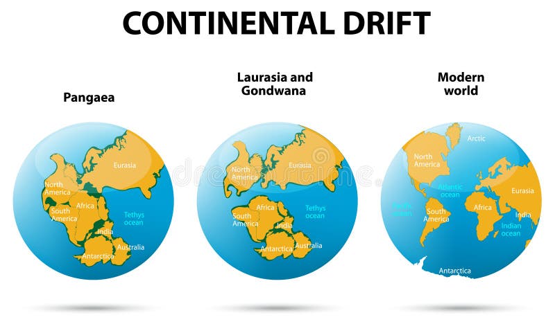
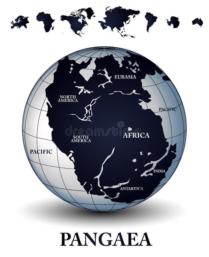
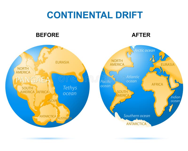
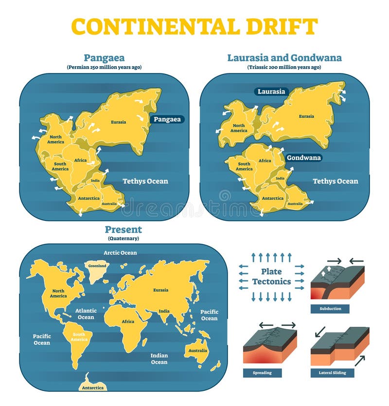
Free with trial Continental drift on the planet Earth. Pangaea, Laurasia, Gondwana, modern continents. Tectonic vectors Continental drift
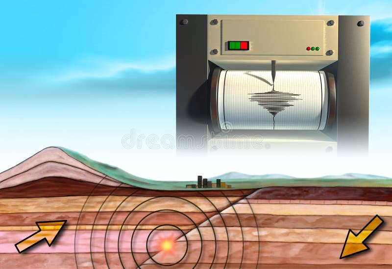
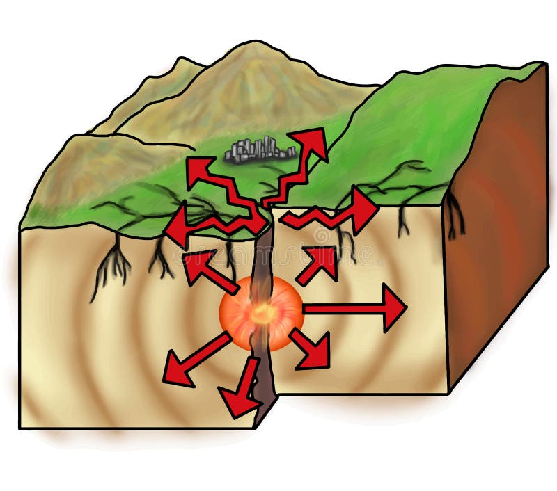
Free with trial Earthquake schematic showing an earth cross-section and a seismograph. Digital illustration. Tectonic illustrations Earthquake
Free with trial A world map with hypsometric tints and a shaded relief for the continents as well as the bathymetry to display the earth' topography. Tectonic illustrations Colorful World Map with Relief. A world map with hypsometric tints and a shaded relief for the continents as well as the bathymetry to display the earth' topography.
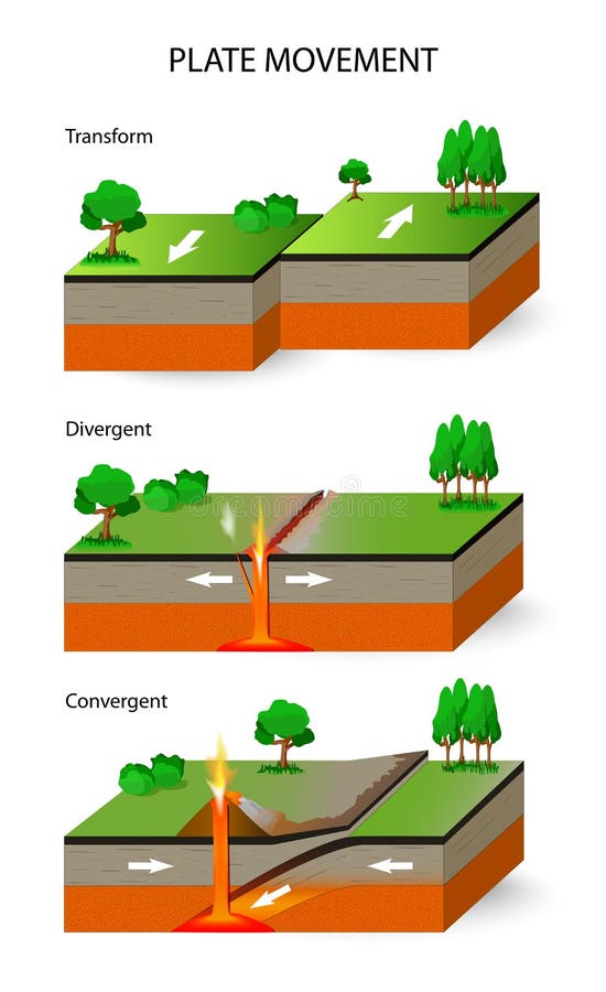
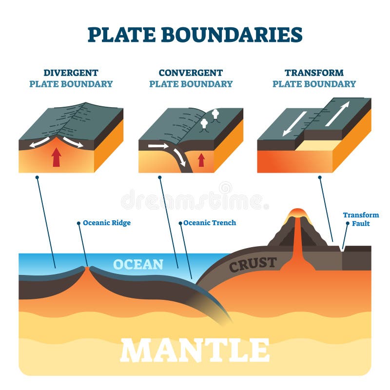
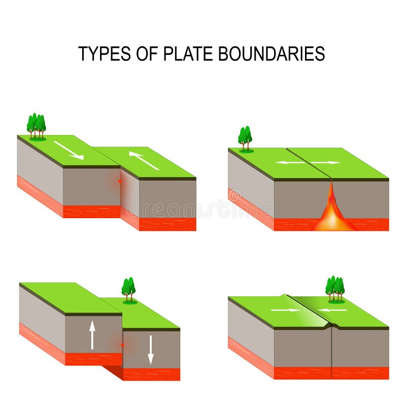
Free with trial Plate movement. A cross section illustrating the main types of tectonic plate boundaries. convergent, divergent, and transform. Tectonic vectors Tectonic Plates. Plate movement. Plate movement. A cross section illustrating the main types of tectonic plate boundaries. convergent, divergent, and transform
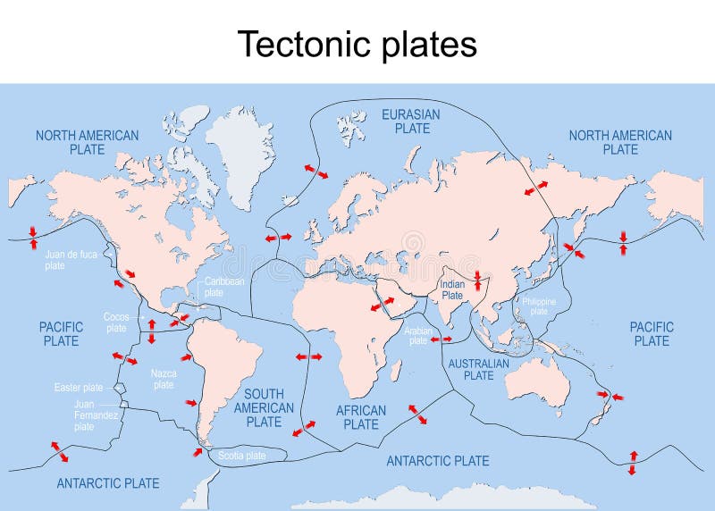
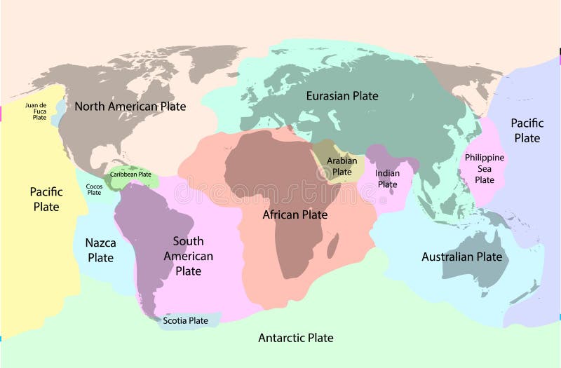
Free with trial Tectonic plates. World map with major an minor plates. Vector illustration. Tectonic vectors Tectonic plates. map. Tectonic plates. World map with major an minor plates. Vector illustration.
Free with trial A cross section illustrating the main types of tectonic plate boundaries. convergent, divergent, or transform. Earthquakes, volcanic activity, mountain-building, and oceanic trench formation occur along these plate boundaries. Tectonic vectors Tectonic plate boundaries
Free with trial Vector illustration of Tectonic Plates - Subduction zone - oceanic trench. Full compatible. Created with gradients. Tectonic vectors Tectonic Plates - Subduction zone
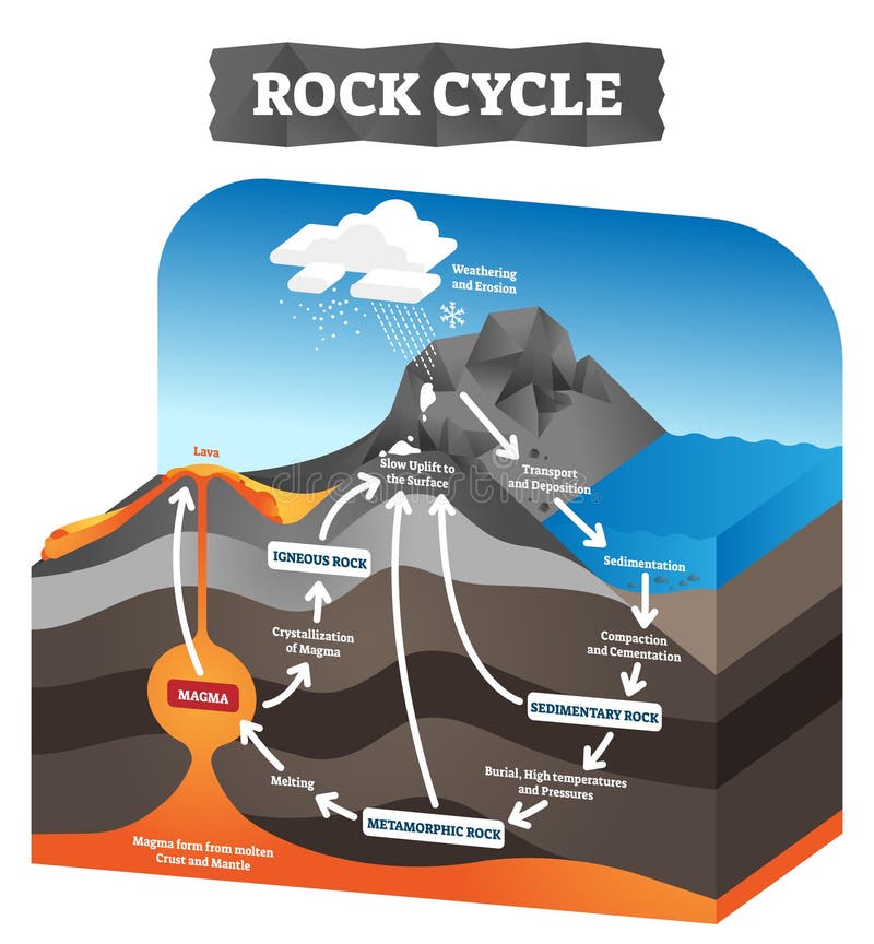
Free with trial Rock cycle vector illustration. Educational labeled geology process scheme. Diagram with sedimentary, metamorphic and igneous formation. Pressure force impact on tectonic plates. Ground erosion layers. Tectonic vectors Rock cycle vector illustration. Educational labeled geology process scheme.
Free with trial Convergent plate boundary created by two continental plates that slide towards each other. Digital illustration. Tectonic illustrations Plates tectonic. Convergent plate boundary created by two continental plates that slide towards each other. Digital illustration.
Free with trial Earth's fault lines between tectonic plates. Tectonic illustrations Earth's fault lines
Free with trial Section of the earth's crust. Tectonic illustrations Tectonic plates of the Earth's crust. Section of the earth's crust
Free with trial Section of the earth's crust. Tectonic illustrations Tectonic plates of the Earth's crust. Section of the earth's crust
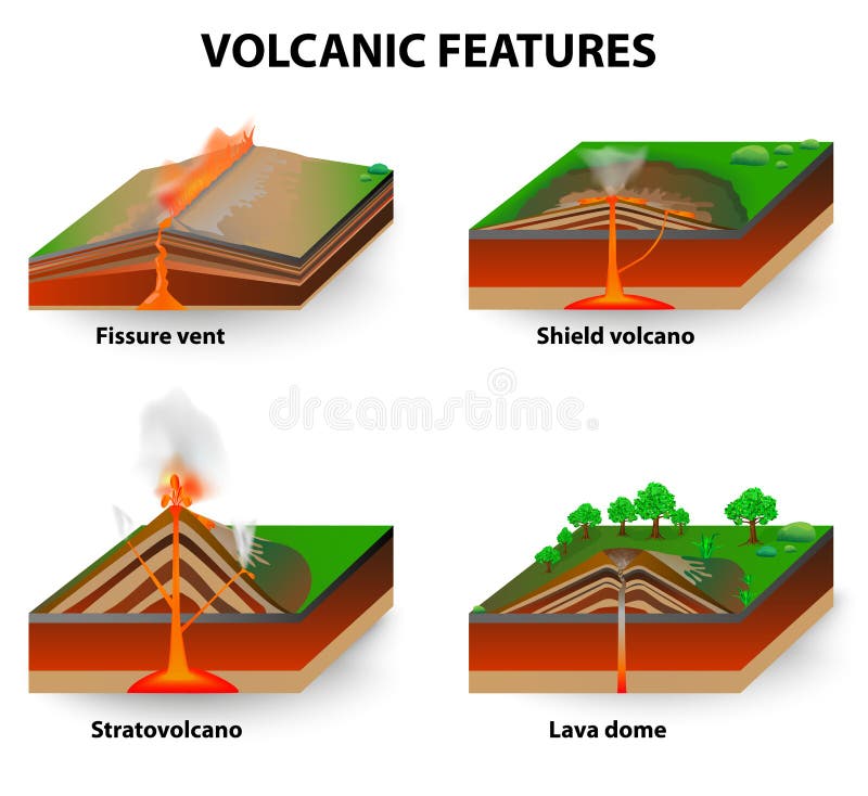
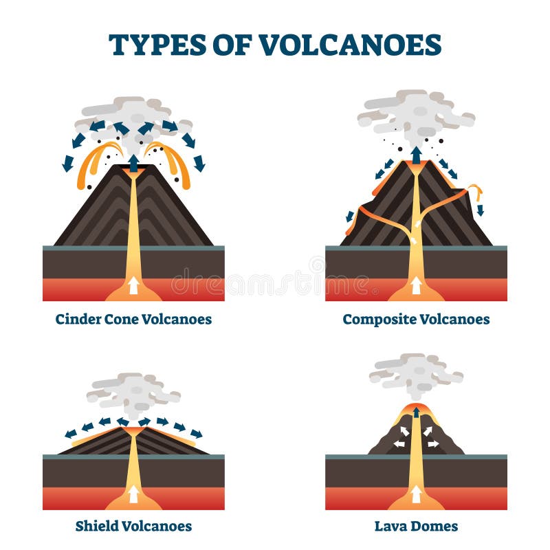
Free with trial Types of volcano. Volcanic eruptions produce volcanoes of different shapes, depending on the type of eruption and geology. Fissure vents, Shield volcanoes, Lava domes and stratovolcano. diagram. Tectonic vectors Volcanic features. Types of volcano. Volcanic eruptions produce volcanoes of different shapes, depending on the type of eruption and geology. Fissure vents, Shield volcanoes, Lava domes and stratovolcano. diagram
Free with trial Planet earth before and after vector illustration background. Tectonic vectors Planet earth before and after
Free with trial Types of geological faults. Transform and Thrust fault, horst and graben. vector. Tectonic vectors Fault geology. Types of geological faults. Transform and Thrust fault, horst and graben. vector
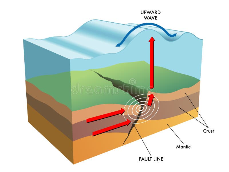
Free with trial Schematic representation of earthquake epicenter. Tectonic vectors Earthquake Epicenter
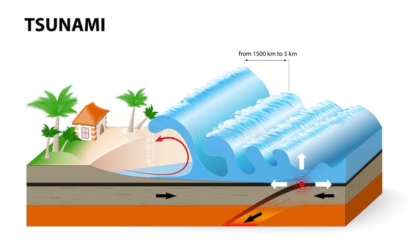
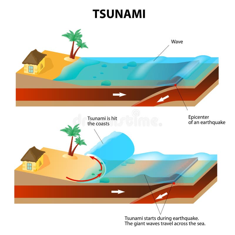
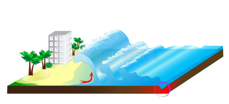
Free with trial A tsunami is a series of huge waves. It washes against the coast several times with great speed and force. Tsunamis generated by submarine earthquakes travel at subsonic speed across the ocean surface. Tectonic vectors A tsunami is a series of huge waves
Free with trial Architecture and ornaments vector set on white. Tectonic vectors Architecture and ornaments vector set
Free with trial A tsunami is a series of huge waves. It washes against the coast several times with great speed and force. Tsunamis generated by submarine earthquakes travel at subsonic speed across the ocean surface. Tectonic vectors Tsunami and Earthquake. Vector illustration. A tsunami is a series of huge waves. It washes against the coast several times with great speed and force. Tsunamis generated by submarine earthquakes travel at subsonic speed across the ocean surface.
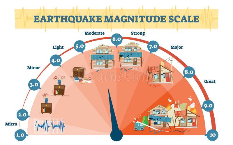
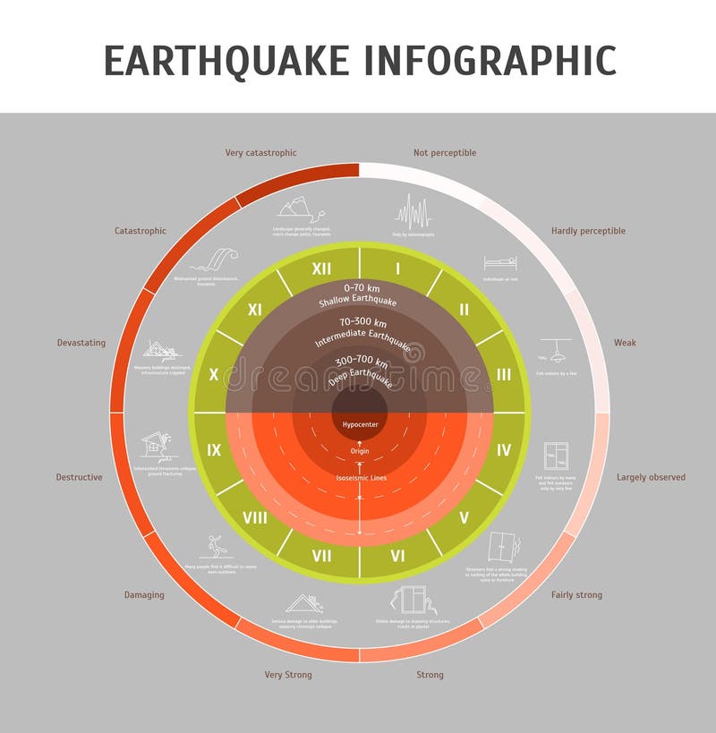
Free with trial Earthquake magnitude levels vector illustration diagram, Richter scale seismic activity diagram with shaking intensity, from moving furniture to crashing buildings. Tectonic vectors Earthquake magnitude levels vector illustration diagram, Richter scale seismic activity diagram. Earthquake magnitude levels vector illustration diagram, Richter scale seismic activity diagram with shaking intensity, from moving furniture to crashing buildings.
Free with trial Seismic activity isometric vector illustration outdoor nature scene diagram with two moving plates and focus epicenter. Tectonic vectors Seismic activity isometric vector illustration with two moving plates and focus epicenter. Seismic activity isometric vector illustration outdoor nature scene diagram with two moving plates and focus epicenter.
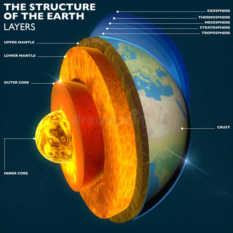
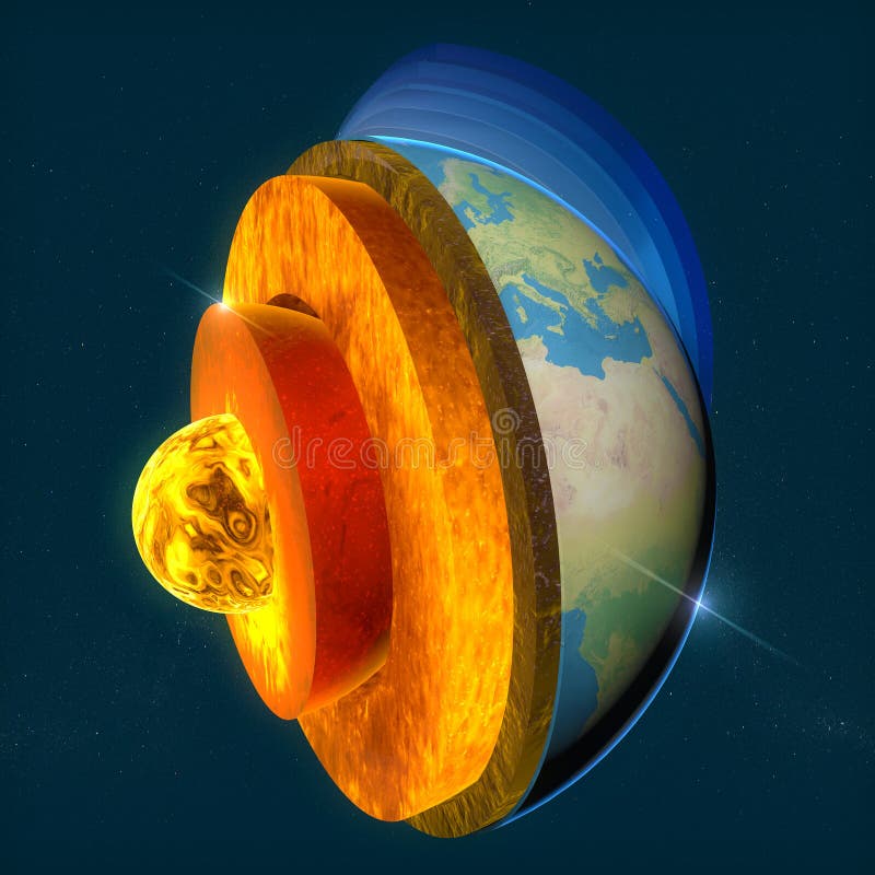
Free with trial Earth's core, section layers earth and sky, split, geophysics. Tectonic illustrations Earth's core, section layers earth and sky
Free with trial Three types of plate boundaries exist. This is Transform boundaries (Conservative). Tectonic illustrations Plate boundaries, transform boundaries, earthquake. Three types of plate boundaries exist. This is Transform boundaries (Conservative)
Free with trial Volcano eruption in the ocean, background of some objects with grunge. Tectonic vectors Volcano eruption in the ocean
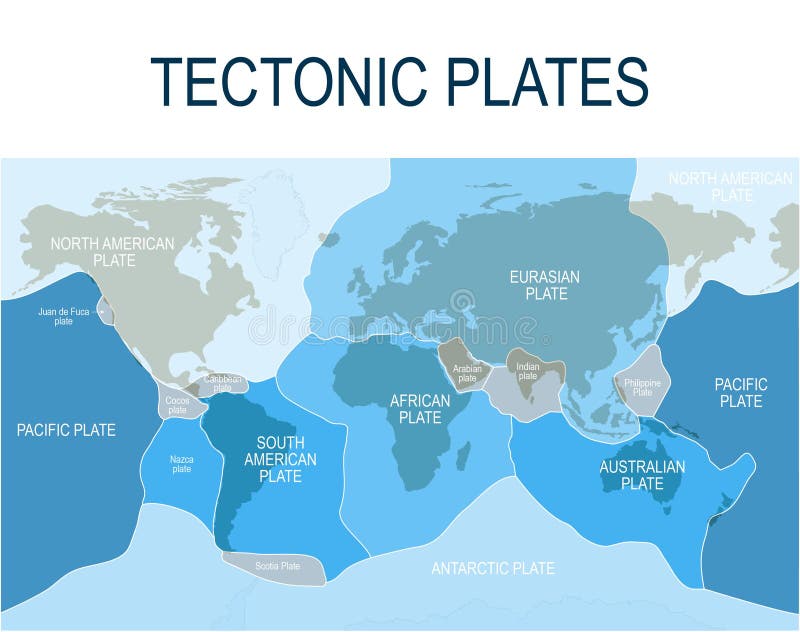
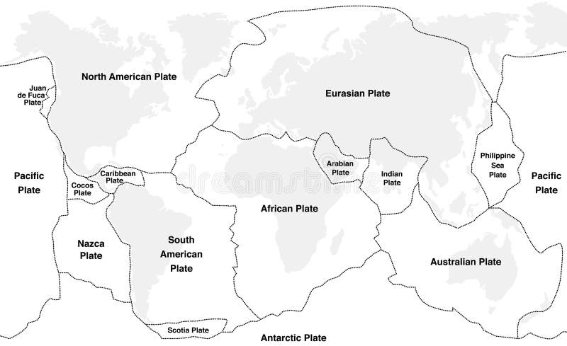
Free with trial Tectonic plates of planet earth - map with names of major an minor plates. Tectonic vectors Tectonic Plates
Free with trial Tectonic plate earth map. Continental ocean pacific, volcano lithosphere geography plates. Tectonic vectors Tectonic plate earth map. Continental ocean pacific, volcano lithosphere geography plates
Free with trial Map of Earth`s principal tectonic plates. Earth`s lithosphere. Major and minor plates. arrows indicate direction of movement at plate boundaries. Vector illustration. Tectonic vectors Map of Earth`s principal tectonic plates. Earth`s lithosphere. Major and minor plates. arrows indicate direction of movement at plate boundaries. Vector
Free with trial Tectonic Plates world map collection, vector diagram and tectonic movement illustrations. Tectonic vectors Tectonic Plates world map collection, vector diagram
Free with trial Earth's fault lines between tectonic plates in the East Asia region. Tectonic illustrations Earth's fault lines between tectonic plates
Free with trial Plate boundaries vector illustration. Labeled tectonic movement comparison. Scheme with divergent, convergent and transform. Side view structure explanation with oceanic ridge, trench and mantle fault. Tectonic vectors Plate boundaries vector illustration. Labeled tectonic movement comparison.
Free with trial Tectonic plates fit together to make up Earth’s surface. These plates move, bump together, overlap, and slide past each other, in the process making new areas of ocean floor, building mountains, causing earthquakes, and creating volcanoes. 3d rendering. Element of this image are furnished by Nasa. Tectonic illustrations Tectonic plates move constantly, making new areas of ocean floor, building mountains, causing earthquakes, and creating volcanoes. Tectonic plates fit together to make up Earth’s surface. These plates move, bump together, overlap, and slide past each other, in the process making new areas of ocean floor, building mountains, causing earthquakes, and creating volcanoes. 3d rendering. Element of this image are furnished by Nasa
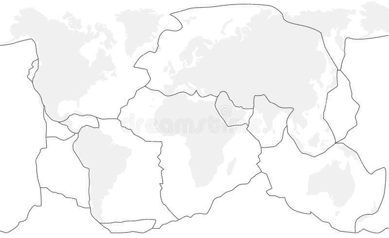
Free with trial Tectonic plates unlabeled - world map with fault lines of major an minor plates. Tectonic vectors Tectonic Plates Unlabeled
Free with trial Vector illustration shows divergence of continental tectonic plates. Tectonic vectors Continental plates-divergence. Vector illustration shows divergence of continental tectonic plates
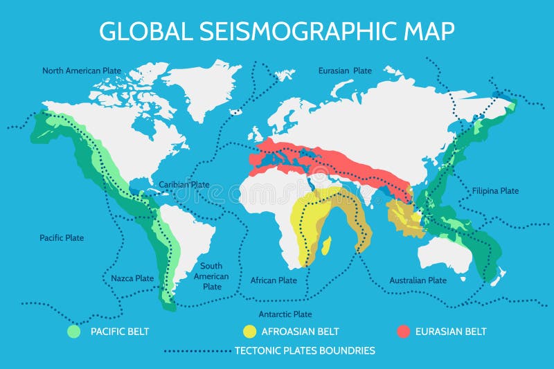
Free with trial World Seismographic Map with Earthquake Pacific Afroasian and Eurasian Belts and Main Tectonic Plates. Vector illustration. Tectonic vectors World Seismographic Map with Earthquake Belts and Tectonic Plates. World Seismographic Map with Earthquake Pacific Afroasian and Eurasian Belts and Main Tectonic Plates. Vector illustration
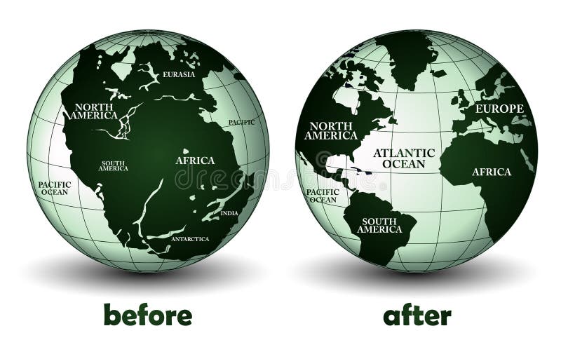
Free with trial Continental drift on the planet Earth. Before (Pangaea - 200 million years ago) and after (modern continents). Tectonic vectors Continental drift on the planet Earth
Free with trial Scientific illustration of the causes and effects of a tsunami. Tectonic vectors Tsunami
Free with trial View of Italian town with buildings, bridge, river and flowers. Hi rez JPEG and EPS8 is available. Tectonic vectors Italy. View of Italian town with buildings, bridge, river and flowers. Hi rez JPEG and EPS8 is available.
Free with trial Tsunami Wave from. Isometric representation of natural disaster. Vector. Tectonic vectors Tsunami
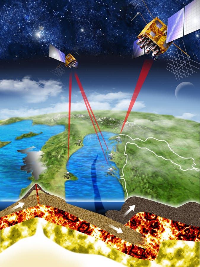
Free with trial Measurements done with GPS satellites under supervision of american-croatian group of scientists under the lead of dr. Richard Bennett from University of Arizona in Tucson discover that coasts of Croatia and Italy are nearing each other 4 mm per year and in 50 to 70 million years there shall be no seawater boundary between them. Tectonic illustrations Adriatic sea bottom trench. Measurements done with GPS satellites under supervision of american-croatian group of scientists under the lead of dr. Richard Bennett from University of Arizona in Tucson discover that coasts of Croatia and Italy are nearing each other 4 mm per year and in 50 to 70 million years there shall be no seawater boundary between them.
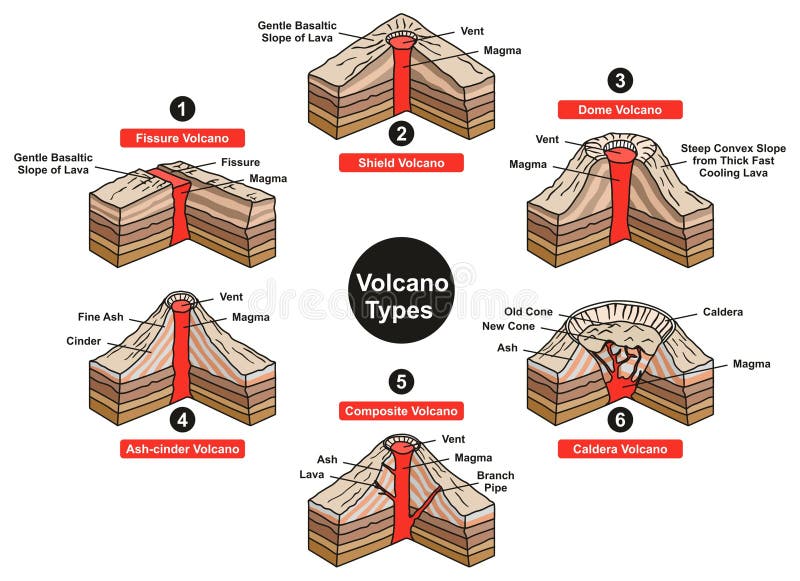
Free with trial Volcano Types Infographic Diagram including fissure sheild dome ash cinder composite and caldera with all parts vent slope magma lava for geology science and natural disaster education. Tectonic vectors Volcano Types Infographic Diagram
Free with trial Vector illustration shows divergence of oceanic plates. Tectonic vectors Oceanic plates-divergence. Vector illustration shows divergence of oceanic plates.
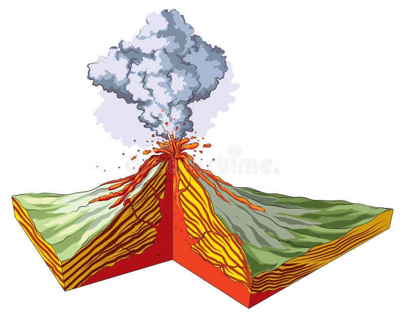
Free with trial Volcano cross section with hot lava and volcanic ash cloud vector diagram. Illustration of volcano mountain, volcanic lava flow. Tectonic vectors Volcano cross section with hot lava and volcanic ash cloud vector diagram
Free with trial Volcano igneous eruption in the cross section. Education scientific scheme for posters, placards, pages, banners, vector illustration. Tectonic vectors Volcano igneous eruption in the cross section. Education scientific scheme
Free with trial Lithosphere vector illustration. Labeled educational earth outer shell scheme. Explanation cross section diagram with asthenosphere, mantle and core structure. Detailed world parts explanation graphic. Tectonic vectors Lithosphere vector illustration. Labeled educational earth outer shell scheme
Free with trial Vector illustraton of collision of two oceanic plates. Tectonic vectors Collision of two oceanic plates
Free with trial Game background 2d game application. Vector design. Tileable horizontally. Size 1024x512. Tectonic vectors Rocks Game Background. Game background 2d game application. Vector design. Tileable horizontally. Size 1024x512
Free with trial Plate tectonics. Earth`s lithosphere. Scientific theory. Illustration shows Boundaries of Major main and minor plates. Continental drift. Tectonic vectors Plate tectonics. Major main and minor plates. Plate tectonics. Earth`s lithosphere. Scientific theory. Illustration shows Boundaries of Major main and minor plates. Continental drift.
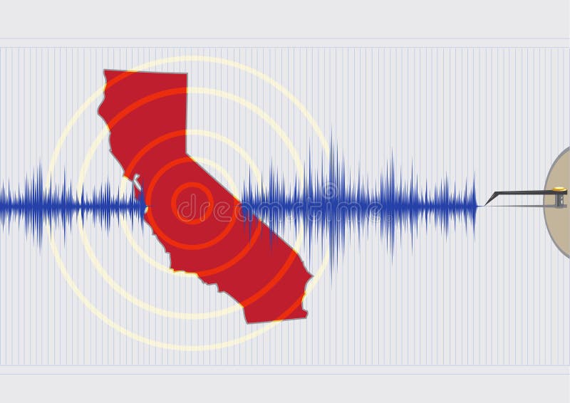
Free with trial Illustration concept of a Califonia Quake with seismic waves drawn by a seismography machine pen on a chart. Vector and Raster versions. Tectonic vectors California Earthquake Concept Vector EPS10 and Raster. Illustration concept of a Califonia Quake with seismic waves drawn by a seismography machine pen on a chart. Vector and Raster versions
Free with trial Earthquake. seismic activity: Seismic waves, fault, focus and epicenter earthquake. Tectonic vectors Earthquake. Seismic waves, fault, focus and epicenter earthquake. Earthquake. seismic activity: Seismic waves, fault, focus and epicenter earthquake
Free with trial Vector illustration of collision of two continental plates. Tectonic vectors Collision of two continental plates
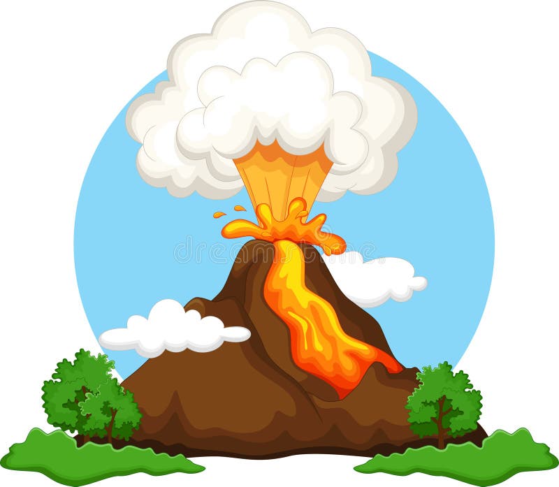
Free with trial Exotic volcano island. Vector illustration. Tectonic vectors Explosing volcano island. Exotic volcano island. Vector illustration
Free with trial Type of volcanoes vector illustration. Labeled geological classification. Geographic cinder cone, composite, shield and lava domes comparison. Different crater mantle lava eruption process infographic. Tectonic vectors Types of volcanoes vector illustration. Labeled geological classification. Type of volcanoes vector illustration. Labeled geological classification. Geographic cinder cone, composite, shield and lava domes comparison. Different crater mantle lava eruption process infographic
Free with trial Continental drift chronological movement, historical timeline with earth continents: Pangaea, Laurasia, Gondwana. Vector illustration world map. Tectonic vectors Continental drift chronological movement, historical timeline with earth continents: Pangaea, Laurasia, Gondwana.
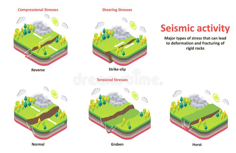
Free with trial Seismic activity diagram. Vector isometric Earth crust compression, shear and tension stresses. Earthquake natural disasters concept for educational poster, scientific infographic, presentation. Tectonic vectors Seismic activity earth crust stresses vector isometric diagram. Seismic activity diagram. Vector isometric Earth crust compression, shear and tension stresses. Earthquake natural disasters concept for educational poster, scientific infographic, presentation.
Free with trial Optical illusion background. Op art. Vector illustration. Tectonic vectors Optical illusion background.
Free with trial Earth's core, section layers earth and sky, split, geophysics. Tectonic illustrations Earth's core, section layers earth and sky
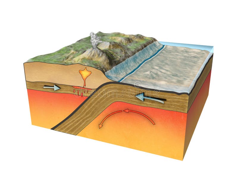
Free with trial Three types of plate boundaries exist. This is Convergent boundaries (Destructive). Tectonic illustrations Plate boundaries, convergent boundaries, earthquak. Three types of plate boundaries exist. This is Convergent boundaries (Destructive)
Free with trial Cartoon Earthquake Magnitude Infographic Concept Card Poster Seismic Disaster Element Flat Design Style. Vector illustration of Quake Intensity Diagram. Tectonic vectors Cartoon Earthquake Magnitude Infographic Concept Card Poster. Vector. Cartoon Earthquake Magnitude Infographic Concept Card Poster Seismic Disaster Element Flat Design Style. Vector illustration of Quake Intensity Diagram
Free with trial Seamless patterns with 3d effect. Vector set. Tectonic vectors Seamless relief patterns. Seamless patterns with 3d effect. Vector set.
Free with trial Three types of plate boundaries exist. This is Divergent boundaries (Constructive). Tectonic illustrations Plate boundaries, divergent boundaries, earthquake. Three types of plate boundaries exist. This is Divergent boundaries (Constructive)
Free with trial Continental drift. Vector illustration of Pangaea, Laurasia, Gondwana, modern continents in flat style. The movement of mainlands on the planet Earth in different periods from 250 MYA to Present. Tectonic vectors Continental drift. Vector illustration of Pangaea, Laurasia, Gondwana, modern continents in flat style. The movement of
Free with trial Earth's core, section layers earth and sky, split, geophysics. Tectonic illustrations Earth's core, section layers earth and sky
Free with trial Continental drift. Vector illustration of mainlands on the planet Earth in different periods from 250 MYA to Present in flat style. Pangaea, Laurasia, Gondwana, modern continents. Tectonic vectors Continental drift. Vector illustration of mainlands on the planet Earth in different periods from 250 MYA to Present
Free with trial Earthquake vector illustration with city. Tectonic vectors Earthquake vector illustration
Free with trial Continental drift. The movement of mainlands on the planet Earth in different periods from 250 MYA to Present. Vector illustration of Pangaea, Laurasia, Gondwana, modern continents in flat style. Tectonic vectors Continental drift. The movement of mainlands on the planet Earth in different periods from 250 MYA to Present. Vector
Free with trial Scientific ground cross-section to explain subduction and plate tectonics - 3d illustration. Tectonic illustrations Scientific ground cross-section to explain subduction and plate tectonics
Free with trial Tectonic plate interactions. Types of plate boundaries. Transform boundary occurs where two plates slide against each other in a shear movement. This movement is felt as an earthquake. Tectonic vectors Tectonic plate interactions. Volcanoes, Earthquakes, and Plate T. Tectonic plate interactions. Types of plate boundaries. Transform boundary occurs where two plates slide against each other in a shear movement. This movement is felt as an earthquake.
Free with trial Earth's fault lines between tectonic plates in the East Asia region. Tectonic illustrations Earth's fault lines between tectonic plates
Free with trial Tectonic plate earth map. Continental ocean pacific, volcano lithosphere geography plates. Tectonic vectors Tectonic plate earth map. Continental ocean pacific, volcano lithosphere geography plates
Free with trial Tectonic plate earth map. Continental ocean pacific, volcano lithosphere geography plates. Tectonic vectors Tectonic plate earth map. Continental ocean pacific, volcano lithosphere geography plates
Free with trial Layers of tectonic plates concept. Lithosphere and the structure of the earth. Soil and Limestone. Geography geology background. The scheme of the formation of mountains. Tectonic vectors Layers of tectonic plates concept. Lithosphere and the structure of the earth. Soil and Limestone. Geography geology
Free with trial Tectonic plates and Seismograph - 3D Rendering. Tectonic illustrations Tectonic plates and Seismograph
Free with trial Tectonic plates with names - world map with fault lines of major an minor plates. Tectonic vectors Tectonic Plates Names. Tectonic plates with names - world map with fault lines of major an minor plates.