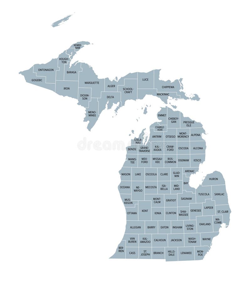
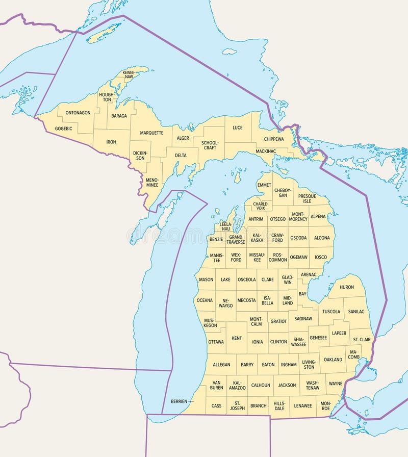
Free with trial Michigan counties, gray political map. A state in the Great Lakes region of the Upper Midwest of the United States, subdivided into 83 counties. Map with county boundaries and names. Illustration. Upper midwestern vectors U.S. state of Michigan, subdivided into 83 counties, gray political map. Michigan counties, gray political map. A state in the Great Lakes region of the Upper Midwest of the United States, subdivided into 83 counties. Map with county boundaries and names. Illustration
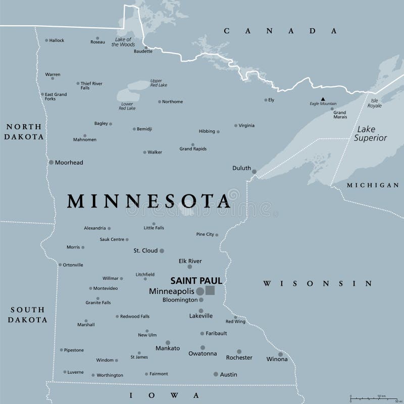
Free with trial Minnesota, MN, political map, with capital Saint Paul and metropolitan area Minneapolis. State in the upper Midwestern United States. Nicknamed Land of 10,000 Lakes, North Star State and Gopher State. Upper midwestern vectors Minnesota, MN, political map, US state, nicknamed Land of 10,000 Lakes. Minnesota, MN, political map, with capital Saint Paul and metropolitan area Minneapolis. State in the upper Midwestern United States. Nicknamed Land of 10,000 Lakes, North Star State and Gopher State.
Free with trial Wisconsin, WI, political map, with the capital Madison and metropolitan area Milwaukee. State in the upper Midwestern United States of America, with the nicknames Badger State, and Americas Dairyland. Upper midwestern vectors Wisconsin, WI, political map, US state, with the nickname Badger State. Wisconsin, WI, political map, with the capital Madison and metropolitan area Milwaukee. State in the upper Midwestern United States of America, with the nicknames Badger State, and Americas Dairyland.
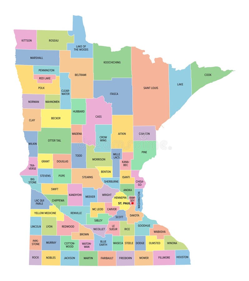
Free with trial Minnesota counties, gray political map. Minnesota, a state in the Upper Midwestern region of the United States, subdivided into 87 counties. Map with boundaries and county names. Illustration. Vector. Upper midwestern vectors U.S. state of Minnesota, subdivided into 87 counties, gray political map. Minnesota counties, gray political map. Minnesota, a state in the Upper Midwestern region of the United States, subdivided into 87 counties. Map with boundaries and county names. Illustration. Vector
Free with trial USA state travel and tourism plate, banner with American Michigan state. Vintage sign and postcard of State in Great Lakes region of upper Midwestern United States, capital is Lansing. Upper midwestern vectors Michigan USA state, vintage travel plate. USA state travel and tourism plate, banner with American Michigan state. Vintage sign and postcard of State in Great Lakes region of upper Midwestern United States, capital is Lansing
Free with trial South Dakota, SD, political map, with capital Pierre, and largest city Sioux Falls. State in the upper Midwestern subregion of the United States of America, nicknamed The Mount Rushmore State. Vector. Upper midwestern vectors South Dakota, SD, political map, US state, The Mount Rushmore State. South Dakota, SD, political map, with capital Pierre, and largest city Sioux Falls. State in the upper Midwestern subregion of the United States of America, nicknamed The Mount Rushmore State. Vector.
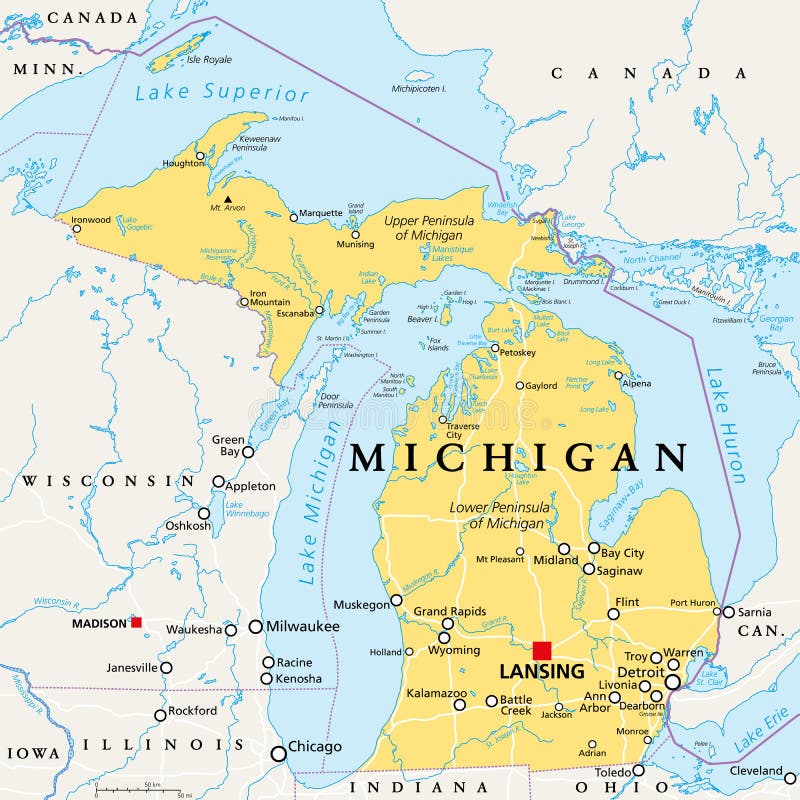
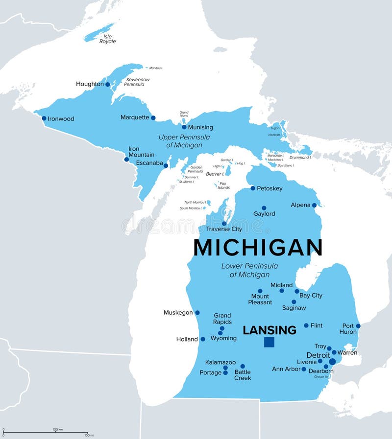
Free with trial Michigan, MI, political map, with capital Lansing and metropolitan area Detroit. State in Great Lakes region of upper Midwestern United States, nicknamed The Great Lake State, and The Wolverine State. Upper midwestern vectors Michigan, MI, political map, US state, nicknamed The Great Lake State. Michigan, MI, political map, with capital Lansing and metropolitan area Detroit. State in Great Lakes region of upper Midwestern United States, nicknamed The Great Lake State, and The Wolverine State.
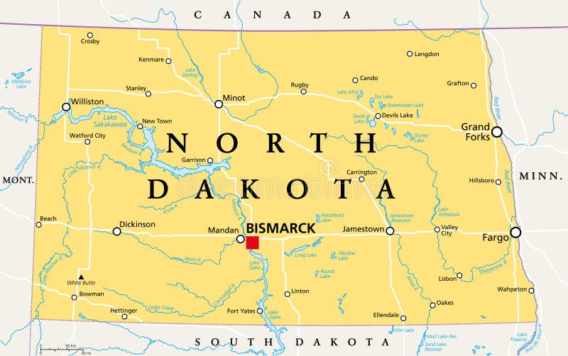
Free with trial North Dakota, ND, political map, with capital Bismarck. State in the upper Midwest subregion of the United States of America, nicknamed Peace Garden State, Roughrider State and Heaven on Earth. Vector. Upper midwestern vectors North Dakota, ND, political map, US state, Peace Garden State. North Dakota, ND, political map, with capital Bismarck. State in the upper Midwest subregion of the United States of America, nicknamed Peace Garden State, Roughrider State and Heaven on Earth. Vector
Free with trial Wisconsin state map, USA. Set of Wisconsin maps with outline border, counties and US states map. Black and white color vector illustration. Upper midwestern vectors Wisconsin state map, USA. Set of Wisconsin maps with outline border, counties and US states map. Black and white color
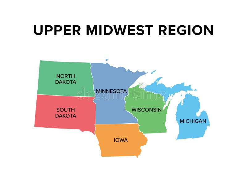
Free with trial Upper Midwest, region of the United States, map. Northern subregion of the Midwestern United States, usually defined to include the states Iowa, Michigan, Minnesota, Wisconsin, North and South Dakota. Upper midwestern vectors Upper Midwest, region of the United States, map
Free with trial Regions of Minnesota, state in the Upper Midwest of the USA. Arrowhead Region or Iron Range, Buffalo Ridge, Central, Minnesota River Valley, Northwest Angle, Red River Valley, Southeast, Twin Cities. Upper midwestern vectors Regions of Minnesota, state in the Upper Midwest of the USA
Free with trial State of Minnesota subdivided into 87 counties, outline map. State in the Upper Midwestern region of the United States, nicknamed North Star State. Map with boundaries and county names. Vector. Upper midwestern vectors State of Minnesota subdivided into 87 counties, outline map
Free with trial Michigan, U. S. state, political map. State in the Great Lakes region of upper Midwestern United States, with capital Lansing and metropolitan area Detroit. The Great Lake State, and Wolverine State. Upper midwestern vectors Michigan, U.S. state, political map
Free with trial Wisconsin, U. S. state, political map. State in the Great Lakes region of upper Midwestern United States, with capital Madison, metropolitan area Milwaukee. The Badger State and America's Dairyland. Upper midwestern vectors Wisconsin, U.S. state, political map
Free with trial Minnesota, U. S. state, subdivided into 87 counties, multi colored political map with capital St. Paul, borders and county names. State in the Upper Midwestern region of the USA. North Star State. Upper midwestern vectors Minnesota, U.S. state, subdivided into 87 counties, multi colored map. Minnesota, U.S. state, subdivided into 87 counties, multi colored political map with capital St. Paul, borders and county names. State in the Upper Midwestern region of the USA. North Star State.
Free with trial Minnesota counties, political map. Minnesota, a state in the Upper Midwestern region of the United States, is subdivided into 87 counties. Map with boundaries and county names. Illustration. Vector. Upper midwestern vectors U.S. state of Minnesota, subdivided into 87 counties, political map. Minnesota counties, political map. Minnesota, a state in the Upper Midwestern region of the United States, is subdivided into 87 counties. Map with boundaries and county names. Illustration. Vector
Free with trial Iowa is a doubly landlocked state in the upper Midwestern region of the United States, text concept on card. Upper midwestern illustrations Iowa is a doubly landlocked state in the upper Midwestern region of the United States, text concept on card
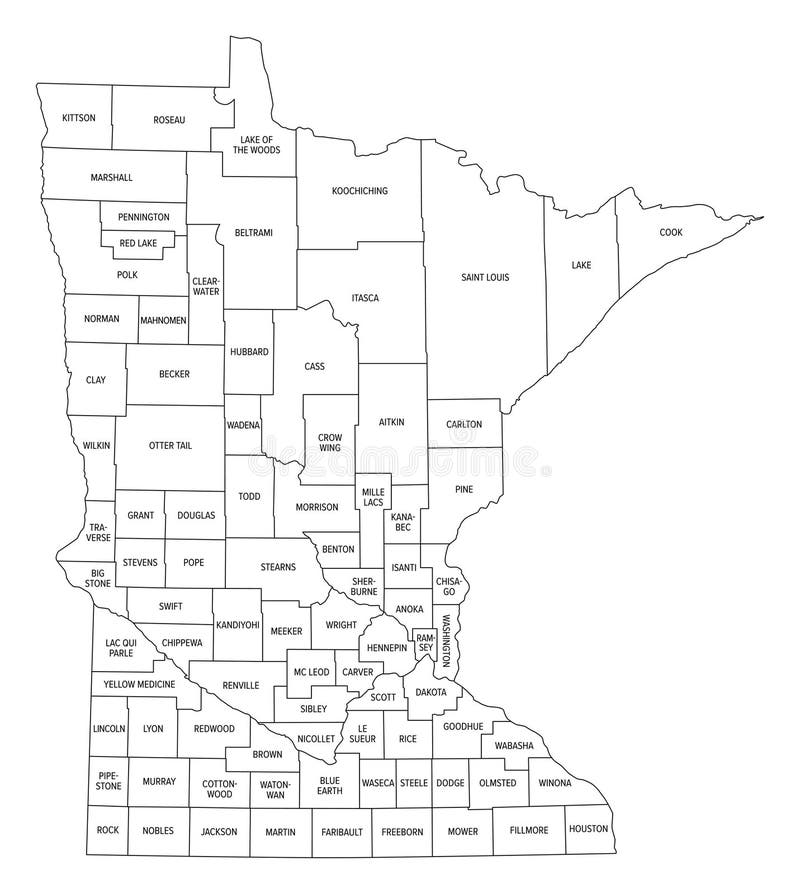
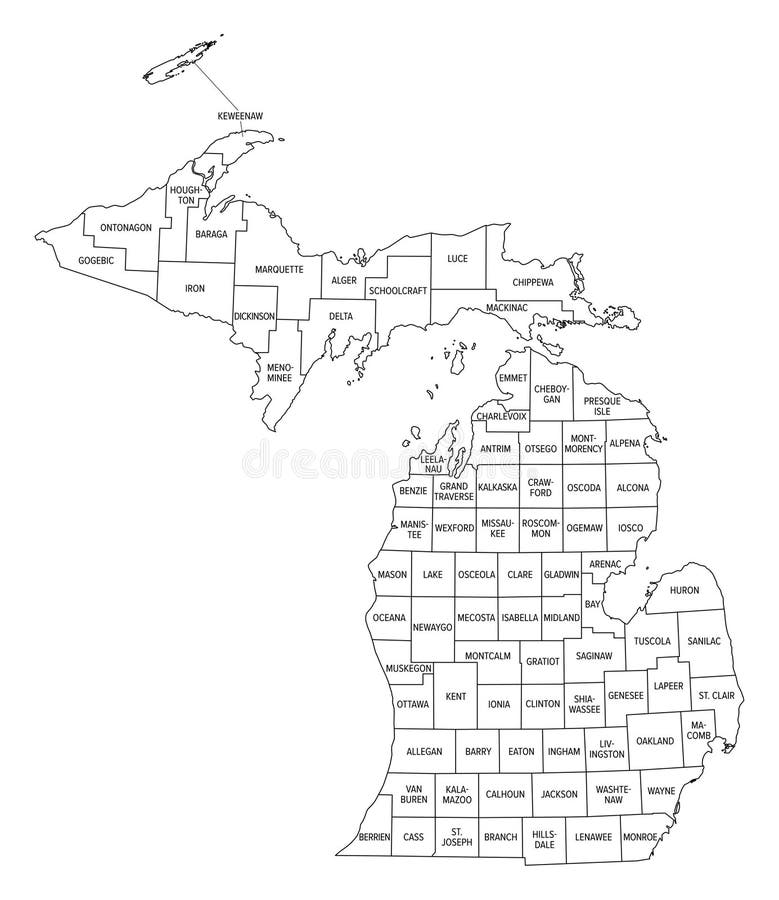
Free with trial State of Michigan divided into counties, outline map. State in the Great Lakes region of the Upper Midwest of United States, subdivided into 83 counties. Map with boundaries and county names. Vector. Upper midwestern vectors State of Michigan divided into counties, outline map
Free with trial Michigan, U. S. state, multi colored political map with borders, county names and capital Lansing. State in the Great Lakes region of the Upper Midwest of the United States, subdivided into 83 counties. Upper midwestern vectors Michigan, U.S. state, subdivided into 83 counties, multi colored map. Michigan, U.S. state, multi colored political map with borders, county names and capital Lansing. State in the Great Lakes region of the Upper Midwest of the United States, subdivided into 83 counties.
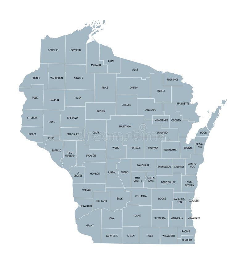
Free with trial Wisconsin counties, gray political map. A state in the Great Lakes region of the Upper Midwest of the United States, subdivided into 72 counties. Map with boundaries and county names. Illustration. Upper midwestern vectors U.S. state of Wisconsin, subdivided into 72 counties, gray political map. Wisconsin counties, gray political map. A state in the Great Lakes region of the Upper Midwest of the United States, subdivided into 72 counties. Map with boundaries and county names. Illustration
Free with trial Wisconsin counties, political map. A state in the Great Lakes region of the Upper Midwest of the United States, subdivided into 72 counties. Map with boundaries and county names. Illustration. Vector. Upper midwestern vectors U.S. state of Wisconsin, subdivided into 72 counties, political map. Wisconsin counties, political map. A state in the Great Lakes region of the Upper Midwest of the United States, subdivided into 72 counties. Map with boundaries and county names. Illustration. Vector
Free with trial Michigan counties, political map. A state in the Great Lakes region of the Upper Midwest of the United States, subdivided into 83 counties. Map with boundaries and county names. Illustration. Vector. Upper midwestern vectors U.S. state of Michigan, subdivided into 83 counties, gray political map. Michigan counties, political map. A state in the Great Lakes region of the Upper Midwest of the United States, subdivided into 83 counties. Map with boundaries and county names. Illustration. Vector
Free with trial This precise silhouette map of Michigan provides a comprehensive geographic outline of the Lower Peninsula and the Upper Peninsula, showcasing the state's distinct shape against a clean black background. Ideal for educational use, classroom presentations, or design projects, this detailed map offers a clear visual representation of Michigan's location within the United States and the surrounding. Upper midwestern illustrations Detailed Black Silhouette Map of Michigan A HighQuality Geographic Outline of the Great Lakes State for Educational and. This precise silhouette map of Michigan provides a comprehensive geographic outline of the Lower Peninsula and the Upper Peninsula, showcasing the state's distinct shape against a clean black background. Ideal for educational use, classroom presentations, or design projects, this detailed map offers a clear visual representation of Michigan's location within the United States and the surrounding
Free with trial Wisconsin, U. S. state, subdivided into 72 counties, multi colored political map with capital Madison, borders and county names. State in the Great Lakes region of the Upper Midwest of United States. Upper midwestern vectors Wisconsin, U.S. state, subdivided into 72 counties, multi colored map. Wisconsin, U.S. state, subdivided into 72 counties, multi colored political map with capital Madison, borders and county names. State in the Great Lakes region of the Upper Midwest of United States.
Free with trial Bright Yellow Daffodil �' Trumpet-Shaped Bloom with Six Delicate Petals on a White Background. Generative with AI. Upper midwestern illustrations . Bright Yellow Daffodil �' Trumpet-Shaped Bloom with Six Delicate Petals on a White Background. Generative with AI
Free with trial Discover a vintage map of Menominee, Michigan, and Marinette, Wisconsin, United States, twin port cities located along the scenic Menominee River at the edge of Green Bay. Known for their Great Lakes heritage, historic downtowns, and 19th-century architecture, these neighboring cities showcase the charm of early Midwestern industry and maritime trade. This antique cartography highlights engraved artwork, city planning, and waterfront landmarks, making it ideal for collectors, educators, and history enthusiasts fascinated by the cultural and architectural evolution of the Upper Midwest. Upper midwestern illustrations . Discover a vintage map of Menominee, Michigan, and Marinette, Wisconsin, United States, twin port cities located along the scenic Menominee River at the edge of Green Bay. Known for their Great Lakes heritage, historic downtowns, and 19th-century architecture, these neighboring cities showcase the charm of early Midwestern industry and maritime trade.This antique cartography highlights engraved artwork, city planning, and waterfront landmarks, making it ideal for collectors, educators, and history enthusiasts fascinated by the cultural and architectural evolution of the Upper Midwest.
Free with trial High-resolution 8k aerial render showcasing a massive agrivoltaic solar farm. The image captures a sophisticated "dual-use" agricultural system where elevated photovoltaic panels are arranged in precise geometric patterns above flourishing green crop rows. Set in a vast Midwestern landscape, the composition features clear service paths and irrigation channels, all under bright midday sunlight that creates sharp, authentic shadows and crisp glass reflections. The upper 45% of the frame is a vibrant blue sky with scattered fluffy white clouds, specifically designed to provide extensive negative copy space for high-impact sustainability headlines, corporate ESG branding, and renewable energy marketing. Ideal for clean-tech brochures, agricultural innovation reports, and environmental web headers. Devoid of artifacts, human figures, or brand logos. Upper midwestern illustrations AI Generated Aerial Agrivoltaic Solar Farm with Geometric Crop Rows and Wide Sky Copy Space. AI Generated high-resolution 8k aerial render showcasing a massive. high-resolution 8k aerial render showcasing a massive agrivoltaic solar farm. The image captures a sophisticated "dual-use" agricultural system where elevated photovoltaic panels are arranged in precise geometric patterns above flourishing green crop rows. Set in a vast Midwestern landscape, the composition features clear service paths and irrigation channels, all under bright midday sunlight that creates sharp, authentic shadows and crisp glass reflections. The upper 45% of the frame is a vibrant blue sky with scattered fluffy white clouds, specifically designed to provide extensive negative copy space for high-impact sustainability headlines, corporate ESG branding, and renewable energy marketing. Ideal for clean-tech brochures, agricultural innovation reports, and environmental web headers. Devoid of artifacts, human figures, or brand logos.
Free with trial A stylized, abstract outline of the state of Michigan is depicted in a deep blue color against a clean white background. The shape is rendered with a slightly textured, brushstroke-like quality, giving it an artistic and modern feel. A subtle, thin halo or loop is positioned above the northernmost point of the state, suggesting a sense of uniqueness, specialness, or perhaps a playful nod to the Great Lakes region's beauty. This graphic is versatile for use in travel, regional branding, or conceptual design projects. Upper midwestern illustrations Abstract Blue Michigan State Outline with Halo. A stylized, abstract outline of the state of Michigan is depicted in a deep blue color against a clean white background. The shape is rendered with a slightly textured, brushstroke-like quality, giving it an artistic and modern feel. A subtle, thin halo or loop is positioned above the northernmost point of the state, suggesting a sense of uniqueness, specialness, or perhaps a playful nod to the Great Lakes region's beauty. This graphic is versatile for use in travel, regional branding, or conceptual design projects.
Free with trial Minimalist white-on-black outline of the state of Michigan, USA. Sleek, modern design featuring the silhouette of Michigan�including both the Upper and Lower Peninsulas�in white against a black background. Ideal for maps, state-themed branding, travel marketing, educational graphics, or minimalist design projects highlighting U. S. geography. Upper midwestern vectors Michigan State Outline Vector Minimalist White on Black Design. Minimalist white-on-black outline of the state of Michigan, USA. Sleek, modern design featuring the silhouette of Michigan�including both the Upper and Lower Peninsulas�in white against a black background. Ideal for maps, state-themed branding, travel marketing, educational graphics, or minimalist design projects highlighting U.S. geography.
Free with trial Michigan state of great lakes travel plate, USA banner or vintage tin plaque. Vintage sign and postcard of region of upper Midwestern United States, capital is Lansing, retro postcard. Upper midwestern vectors Michigan USA state, vintage travel plate. Michigan state of great lakes travel plate, USA banner or vintage tin plaque. Vintage sign and postcard of region of upper Midwestern United States, capital is Lansing, retro postcard
Free with trial Grunge rubber stamp with name of North Dakota, Upper Midwestern. Upper midwestern vectors North Dakota, Upper Midwestern stamp. Grunge rubber stamp with name of North Dakota, Upper Midwestern
Free with trial Tourist map of North Dakota. Is a U. S. state in the upper Midwestern United States. Upper midwestern vectors Map of North Dakota
Free with trial Flags of Iowa and the United States waving in the wind on a clear day. State in the upper Midwestern region of the United States. 3d illustration render. Fluttering fabric. Upper midwestern illustrations Flags of Iowa and the United States waving in the wind on a clear day
Free with trial Close-up of Wisconsin state flag waving in the wind. Upper Midwestern United States state. 3d illustration render. Fluttering fabric. Upper midwestern illustrations Close-up of Wisconsin state flag waving in the wind
Free with trial Flags of Iowa and the United States waving in the wind on a clear day. State in the upper Midwestern region of the United States. 3d illustration render. Fluttering fabric. Upper midwestern illustrations Flags of Iowa and the United States waving in the wind on a clear day
Free with trial Wisconsin, WI, gray political map, with the capital Madison and the metropolitan area Milwaukee. State in the upper Midwestern United States of America, nicknamed Badger State, and Americas Dairyland. Upper midwestern vectors Wisconsin, WI, gray political map, US state, Badger State. Wisconsin, WI, gray political map, with the capital Madison and the metropolitan area Milwaukee. State in the upper Midwestern United States of America, nicknamed Badger State, and Americas Dairyland.
Free with trial Michigan, MI, gray political map with capital Lansing and metropolitan area Detroit. State in the Great Lakes region of upper Midwestern United States, nicknamed Great Lake State, and Wolverine State. Upper midwestern vectors Michigan, MI, gray political map, US state, The Great Lake State. Michigan, MI, gray political map with capital Lansing and metropolitan area Detroit. State in the Great Lakes region of upper Midwestern United States, nicknamed Great Lake State, and Wolverine State.
Free with trial Minnesota, MN, gray political map with capital Saint Paul and metropolitan area Minneapolis. State in upper Midwestern United States. Nicknamed Land of 10,000 Lakes, North Star State and Gopher State. Upper midwestern vectors Minnesota, MN, gray political map, US state, Land of 10,000 Lakes. Minnesota, MN, gray political map with capital Saint Paul and metropolitan area Minneapolis. State in upper Midwestern United States. Nicknamed Land of 10,000 Lakes, North Star State and Gopher State.
Free with trial South Dakota, SD, gray political map, with capital Pierre, and largest city Sioux Falls. State in the upper Midwestern subregion of United States of America, nicknamed The Mount Rushmore State. Vector. Upper midwestern vectors South Dakota, SD, gray political map, US state, The Mount Rushmore State. South Dakota, SD, gray political map, with capital Pierre, and largest city Sioux Falls. State in the upper Midwestern subregion of United States of America, nicknamed The Mount Rushmore State. Vector
Free with trial Minnesota north star state travel plate, USA tourism banner with constellation sign. Vintage postcard of Saint Paul capital, Minneapolis city. State in Upper Midwestern region of United States. Upper midwestern illustrations Minnesota USA state travel plate, tourism banner. Minnesota north star state travel plate, USA tourism banner with constellation sign. Vintage postcard of Saint Paul capital, Minneapolis city. State in Upper Midwestern region of United States
Free with trial Minnesota north star travel plate, state in Upper Midwestern region of United States. Vector USA tourism banner with constellation sign. Minneapolis city, vintage postcard of Saint Paul capital. Upper midwestern vectors Minnesota USA state travel plate, tourism banner. Minnesota north star travel plate, state in Upper Midwestern region of United States. Vector USA tourism banner with constellation sign. Minneapolis city, vintage postcard of Saint Paul capital
Free with trial Close-up view of the Minnesota state flag waving. Minnesota is a state in the upper midwestern region of the United States. Fabric textured background. Upper midwestern illustrations Close-up view of the Minnesota state flag waving
Free with trial The US state flag of Michigan waving in the wind. MIchigan is a state in the Great Lakes region of the upper Midwestern United States. Democracy and independence. Upper midwestern illustrations The US state flag of Michigan waving in the wind
Free with trial The US state flag of Minnesota waving in the wind. Minnesota is a state in the upper midwestern region of the United States. Rippled textile background. Realistic 3d illustration. US state flag. Upper midwestern illustrations The US state flag of Minnesota waving in the wind
Free with trial The Wisconsin state flag waving along with the national flag of the United States of America. Wisconsin is a state in the upper Midwestern United States. Upper midwestern illustrations The Wisconsin state flag waving along with the national flag of the United States of America
Free with trial Michigan MI Map Clouds USA United States America Weather Forecast 3d Illustration. Upper midwestern illustrations Michigan MI Map Clouds USA United States America Weather Forecast 3d Illustration
Free with trial North Dakota, ND, gray political map, with capital Bismarck. State in the upper Midwest subregion of United States of America nicknamed Peace Garden State, Roughrider State and Heaven on Earth. Vector. Upper midwestern vectors North Dakota, ND, gray political map, US state, Peace Garden State. North Dakota, ND, gray political map, with capital Bismarck. State in the upper Midwest subregion of United States of America nicknamed Peace Garden State, Roughrider State and Heaven on Earth. Vector
Free with trial Michigan Map United States America Growth Increase Improve 3d Illustration. Upper midwestern illustrations Michigan Map United States America Growth Increase Improve
Free with trial The Dakotas, gray political map. Collective term for the US states of North Dakota and South Dakota, in the Upper Midwest and North Central. Used to describe Dakota Territory and collective heritage. Upper midwestern vectors The Dakotas, US states North Dakota and South Dakota, gray political map. The Dakotas, gray political map. Collective term for the US states of North Dakota and South Dakota, in the Upper Midwest and North Central. Used to describe Dakota Territory and collective heritage.
Free with trial The Dakotas, political map. Collective term for the U. S. states of North Dakota and South Dakota, in the Upper Midwest and North Central. Used to describe the Dakota Territory and collective heritage. Upper midwestern vectors The Dakotas, the US states North Dakota and South Dakota, political map. The Dakotas, political map. Collective term for the U.S. states of North Dakota and South Dakota, in the Upper Midwest and North Central. Used to describe the Dakota Territory and collective heritage.
Free with trial Michigan State Map USA United States America Flag 3d Illustration. Upper midwestern illustrations Michigan State Map USA United States America Flag
Free with trial Fabric texture of the North Dakota Flag background - Flags from the USA. Upper midwestern illustrations Fabric texture of the North Dakota Flag - Flags from the USA. Fabric texture of the North Dakota Flag background - Flags from the USA
Free with trial Flag of North Dakota State of North Dakota, USA, vector set of isometric flat icons, 3D style. Editable design element for banner, website, presentation, infographic, poster, map, collage. Eps 10. Upper midwestern vectors Flag of North Dakota USA, vector isometric icon. Flag of North Dakota State of North Dakota, USA, vector set of isometric flat icons, 3D style. Editable design element for banner, website, presentation, infographic, poster, map, collage. Eps 10
Free with trial Isometric map and flag of North Dakota. 3D isometric shape of North Dakota State. Vector Illustration. Upper midwestern vectors North Dakota Isometric map and flag. Vector Illustration. Isometric map and flag of North Dakota. 3D isometric shape of North Dakota State. Vector Illustration
Free with trial The North Dakota state flag waving along with the national flag of the United States of America. In the background there is a clear sky. North Dakota is a U. S. state in the Upper Midwest. Upper midwestern illustrations The North Dakota state flag waving along with the national flag of the United States of America