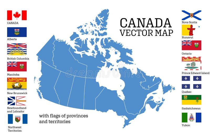
Free with trial Canada map with flags of provinces and territories. Vector illustration. Ottawa, Toronto, Vancouver. Vancouver island map shape vectors Canada map with flags of provinces and territories. Vector illustration
Free with trial Stamp Postal of Vancouver Island. Map Silhouette rubber Seal. Design Retro Travel. Seal Map of Vancouver Island grunge for your design. Canada. EPS10. Vancouver island map shape vectors Stamp Postal of Vancouver Island. Map Silhouette rubber Seal. Design Retro Travel. Seal Map of Vancouver Island
Free with trial Washington state road and national park vector map. Vancouver island map shape vectors Washington state road and national park vector map
Free with trial Vector flags of provinces and territories of Canada. Vector illustration. Ottawa, Toronto, Vancouver. Vancouver island map shape vectors Flags of Canadians provinces and territories. Vector illustration. Vector flags of provinces and territories of Canada. Vector illustration. Ottawa, Toronto, Vancouver
Free with trial Shape of Vancouver Island in the North Pacific Ocean, belonging to Canada. Vancouver island map shape illustrations Shape of Vancouver Island. Canada. Yellow. Shape of Vancouver Island in the North Pacific Ocean, belonging to Canada
Free with trial With Greater Vancouver, British Columbia, Canada and parts of Washington State, United States. Touristic map with key places and cities as text. Shapes are optimized. Vancouver island map shape vectors Vancouver Island Map, tourist map. With Greater Vancouver, British Columbia, Canada and parts of Washington State, United States. Touristic map with key places and cities as text. Shapes are optimized
Free with trial Nanaimo, Victoria, Tofino and Greater Vancouver. Canada, British Columbia. Touristic map. Simple grey scale map without text. Shapes are optimized for better readability. Vancouver island map shape vectors Map of Vancouver Island, partial map. Nanaimo, Victoria, Tofino and Greater Vancouver. Canada, British Columbia. Touristic map. Simple grey scale map without text. Shapes are optimized for better readability
Free with trial Vancouver Island in the North Pacific Ocean on a colored elevation map. Vancouver island map shape illustrations Vancouver Island. Canada. Physical. Vancouver Island in the North Pacific Ocean on a colored elevation map
Free with trial And parts of Washington State, United States. Simple grey scale map without text. Shapes are optimized for readability. Vancouver island map shape vectors Vancouver Island Map with Greater Vancouver, British Columbia, Canada. And parts of Washington State, United States. Simple grey scale map without text. Shapes are optimized for readability
Free with trial Canada Map Retro Map. Highly detailed vector illustration. Vancouver island map shape vectors Canada Map Retro Map
Free with trial With outlines of neighboring regions such as Yukon, Northwest Territories, Alberta, Alaska and Washington. Travel destination and touristic map. Vancouver island map shape vectors Simple map of British Columbia, province of Canada. With outlines of neighboring regions such as Yukon, Northwest Territories, Alberta, Alaska and Washington. Travel destination and touristic map
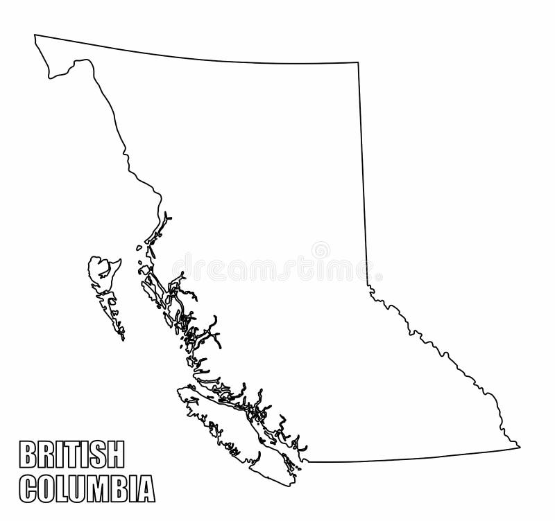
Free with trial The British Columbia province outline map isolated on white background, Canada. Vancouver island map shape illustrations British Columbia province outline map
Free with trial Canada. White shape of BC province with highways and tourist destinations marked. Touristic guide. Vancouver island map shape vectors Beautiful British Columbia Map, Province outline on dark background. Canada. White shape of BC province with highways and tourist destinations marked. Touristic guide
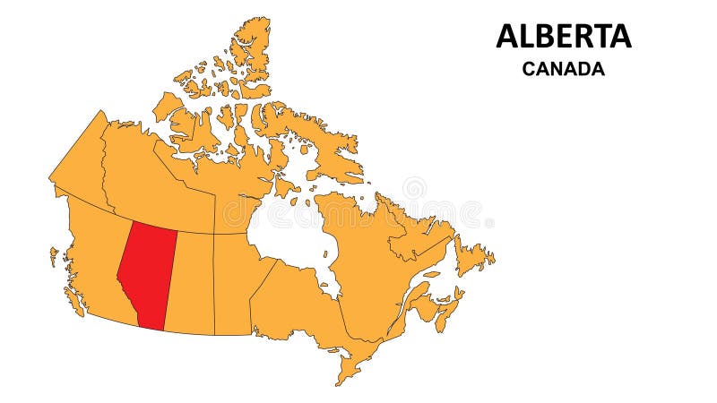
Free with trial Alberta Map is highlighted on the Canada map with detailed state and region outlines n. Vancouver island map shape vectors Alberta Map is highlighted on the Canada map with detailed state and region outlines
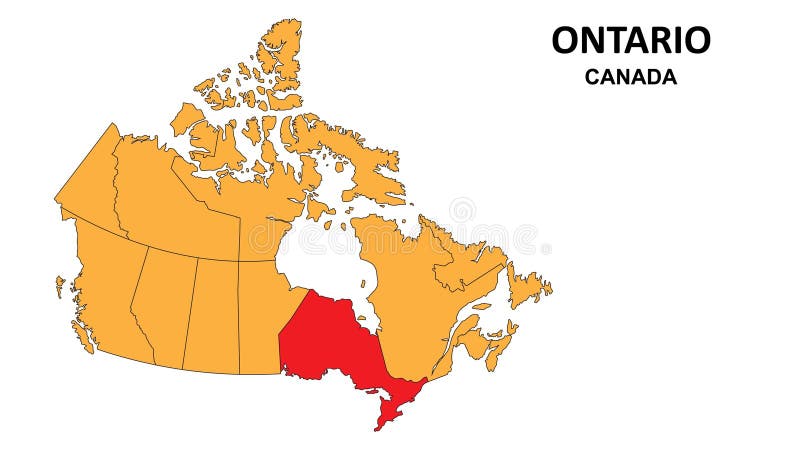
Free with trial Ontario Map is highlighted on the Canada map with detailed state and region outlines n. Vancouver island map shape vectors Ontario Map is highlighted on the Canada map with detailed state and region outlines
Free with trial Canada Vector colored map of provinces and capital cities for north american concepts. Vancouver island map shape vectors Canada Vector colored map of provinces and capital cities for north american concepts
Free with trial Manitoba City Flag, Country Canada, Isolated On White Background. Vancouver island map shape illustrations Manitoba City Flag, Canada, Isolated On White Background
Free with trial Vancouver Island in the North Pacific Ocean, belonging to Canada, isolated on a colored elevation map, with distance scale. Vancouver island map shape illustrations Vancouver Island. Canada. Shape on white. Physical. Vancouver Island in the North Pacific Ocean, belonging to Canada, isolated on a colored elevation map, with distance scale
Free with trial Vancouver Island in the North Pacific Ocean, belonging to Canada, isolated on a bilevel elevation map, with distance scale. Vancouver island map shape illustrations Vancouver Island. Canada. Shape on white. Bilevel. Vancouver Island in the North Pacific Ocean, belonging to Canada, isolated on a bilevel elevation map, with distance scale
Free with trial Vancouver Island in the North Pacific Ocean, belonging to Canada, isolated on a topographic, OSM standard style map, with distance scale. Vancouver island map shape illustrations Vancouver Island. Canada. Shape on white. Topo standard. Vancouver Island in the North Pacific Ocean, belonging to Canada, isolated on a topographic, OSM standard style map, with distance scale
Free with trial Vancouver Island in the North Pacific Ocean - belonging to Canada. Described location diagram with white shape of the island and sample maps of its surroundings. Vancouver island map shape illustrations Vancouver Island. Canada. Location diagram. White. Vancouver Island in the North Pacific Ocean - belonging to Canada. Described location diagram with white shape. Vancouver Island in the North Pacific Ocean - belonging to Canada. Described location diagram with white shape of the island and sample maps of its surroundings
Free with trial Vancouver Island in the North Pacific Ocean, belonging to Canada, described and highlighted on a colored elevation map. Vancouver island map shape illustrations Vancouver Island, Canada, highlighted and labelled. Physical. Vancouver Island in the North Pacific Ocean, belonging to Canada, described and highlighted on a colored elevation map
Free with trial Vancouver Island in the North Pacific Ocean, belonging to Canada, cropped to square on a topographic, OSM Humanitarian style map. Vancouver island map shape illustrations Vancouver Island, Canada, cropped to square. Topo Humanitarian. Vancouver Island in the North Pacific Ocean, belonging to Canada, cropped to square on a topographic, OSM Humanitarian style map
Free with trial Vancouver Island in the North Pacific Ocean on a bilevel elevation map. Vancouver island map shape illustrations Vancouver Island. Canada. Bilevel. Vancouver Island in the North Pacific Ocean on a bilevel elevation map
Free with trial Vancouver Island in the North Pacific Ocean - belonging to Canada. Described location diagram with yellow shape of the island and sample maps of its surroundings. Vancouver island map shape illustrations Vancouver Island. Canada. Location diagram. Yellow. Vancouver Island in the North Pacific Ocean - belonging to Canada. Described location diagram with yellow shape of the island and sample maps of its surroundings
Free with trial Vancouver Island in the North Pacific Ocean, belonging to Canada, cropped to square on a bilevel elevation map. Vancouver island map shape illustrations Vancouver Island, Canada, cropped to square. Bilevel. Vancouver Island in the North Pacific Ocean, belonging to Canada, cropped to square on a bilevel elevation map
Free with trial Vancouver Island in the North Pacific Ocean, belonging to Canada, cropped to square on a colored elevation map. Vancouver island map shape illustrations Vancouver Island, Canada, cropped to square. Physical. Vancouver Island in the North Pacific Ocean, belonging to Canada, cropped to square on a colored elevation map
Free with trial Vancouver Island in the North Pacific Ocean, belonging to Canada, cropped to square on a topographic, OSM standard style map. Vancouver island map shape illustrations Vancouver Island, Canada, cropped to square. Topo standard. Vancouver Island in the North Pacific Ocean, belonging to Canada, cropped to square on a topographic, OSM standard style map
Free with trial Vancouver Island in the North Pacific Ocean, belonging to Canada, described and highlighted on a bilevel elevation map. Vancouver island map shape illustrations Vancouver Island, Canada, highlighted and labelled. Bilevel. Vancouver Island in the North Pacific Ocean, belonging to Canada, described and highlighted on a bilevel elevation map
Free with trial Vancouver Island in the North Pacific Ocean, belonging to Canada, described and highlighted on a topographic, OSM standard style map. Vancouver island map shape illustrations Vancouver Island, Canada, highlighted and labelled. Topo standard. Vancouver Island in the North Pacific Ocean, belonging to Canada, described and highlighted on a topographic, OSM standard style map
Free with trial Vancouver Island in the North Pacific Ocean, belonging to Canada, described and highlighted on a topographic, OSM Humanitarian style map. Vancouver island map shape illustrations Vancouver Island, Canada, highlighted and labelled. Topo Humanitarian. Vancouver Island in the North Pacific Ocean, belonging to Canada, described and highlighted on a topographic, OSM Humanitarian style map
Free with trial Vancouver Island in the North Pacific Ocean on a topographic, OSM Humanitarian style map. Vancouver island map shape illustrations Vancouver Island. Canada. Topo Humanitarian. Vancouver Island in the North Pacific Ocean on a topographic, OSM Humanitarian style map
Free with trial Vancouver Island in the North Pacific Ocean on a topographic, OSM standard style map. Vancouver island map shape illustrations Vancouver Island. Canada. Topo standard. Vancouver Island in the North Pacific Ocean on a topographic, OSM standard style map
Free with trial Vancouver Island in the North Pacific Ocean, belonging to Canada, isolated on a satellite image taken in February 23, 2019, with distance scale. Vancouver island map shape illustrations Vancouver Island. Canada. Shape on white. Satellite, February 23, 2019. Vancouver Island in the North Pacific Ocean, belonging to Canada, isolated on a satellite image taken in February 23, 2019, with distance scale
Free with trial Vancouver Island in the North Pacific Ocean, belonging to Canada, isolated on a Copernicus Sentinel satellite image taken in October 17, 2023, with distance scale. Vancouver island map shape illustrations Vancouver Island. Canada. Shape on white. Satellite, October 17, 2023. Vancouver Island in the North Pacific Ocean, belonging to Canada, isolated on a Copernicus Sentinel satellite image taken in October 17, 2023, with distance scale
Free with trial Vancouver Island in the North Pacific Ocean on a satellite image taken in February 23, 2019. Vancouver island map shape illustrations Vancouver Island. Canada. Satellite, February 23, 2019. Vancouver Island in the North Pacific Ocean on a satellite image taken in February 23, 2019
Free with trial Vancouver Island in the North Pacific Ocean, belonging to Canada, cropped to square on a satellite image taken in October 17, 2023. Vancouver island map shape illustrations Vancouver Island, Canada, cropped to square. Satellite, October 17, 2023. Vancouver Island in the North Pacific Ocean, belonging to Canada, cropped to square on a satellite image taken in October 17, 2023
Free with trial Vancouver Island in the North Pacific Ocean, belonging to Canada, cropped to square on a satellite image taken in February 23, 2019. Vancouver island map shape illustrations Vancouver Island, Canada, cropped to square. Satellite, February 23, 2019. Vancouver Island in the North Pacific Ocean, belonging to Canada, cropped to square on a satellite image taken in February 23, 2019
Free with trial Vancouver Island in the North Pacific Ocean, belonging to Canada, described and highlighted on a satellite image taken in October 17, 2023. Vancouver island map shape illustrations Vancouver Island, Canada, highlighted and labelled. Satellite, October 17, 2023. Vancouver Island in the North Pacific Ocean, belonging to Canada, described and highlighted on a satellite image taken in October 17, 2023
Free with trial Vancouver Island in the North Pacific Ocean on a satellite image taken in October 17, 2023. Vancouver island map shape illustrations Vancouver Island. Canada. Satellite, October 17, 2023. Vancouver Island in the North Pacific Ocean on a satellite image taken in October 17, 2023
Free with trial A clean, minimalist outline map of British Columbia, Canada, presented on a transparent checkered background. The map highlights the distinctive shape of the province, including its intricate coastline and islands. This versatile graphic is ideal for presentations, educational materials, travel guides, and design projects requiring a clear representation of British Columbia's geography. Vancouver island map shape illustrations Outline Map of British Columbia, Canada on Transparent Background. A clean, minimalist outline map of British Columbia, Canada, presented on a transparent checkered background. The map highlights the distinctive shape of the province, including its intricate coastline and islands. This versatile graphic is ideal for presentations, educational materials, travel guides, and design projects requiring a clear representation of British Columbia's geography.
Free with trial A detailed vector illustration of the map of Canada, rendered in a solid dark blue color on a clean white background. This high-quality graphic shows the complete national outline, including the Arctic Archipelago, and clearly delineates the internal borders of all provinces and territories. Its minimalist, flat design makes it a versatile element for infographics, educational materials, presentations, websites, and projects related to Canadian geography, travel, politics, or business. The isolated format provides ample copy space. Vancouver island map shape vectors Vector Map of Canada with Provinces and Territories. A detailed vector illustration of the map of Canada, rendered in a solid dark blue color on a clean white background. This high-quality graphic shows the complete national outline, including the Arctic Archipelago, and clearly delineates the internal borders of all provinces and territories. Its minimalist, flat design makes it a versatile element for infographics, educational materials, presentations, websites, and projects related to Canadian geography, travel, politics, or business. The isolated format provides ample copy space.
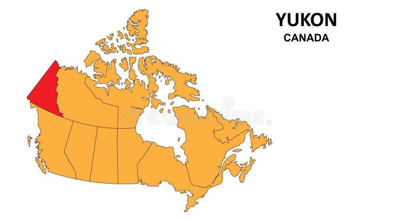
Free with trial Yukon Map is highlighted on the Canada map with detailed state and region outlines n. Vancouver island map shape vectors Yukon Map is highlighted on the Canada map with detailed state and region outlines
Free with trial Quebec Map is highlighted on the Canada map with detailed state and region outlines n. Vancouver island map shape vectors Quebec Map is highlighted on the Canada map with detailed state and region outlines
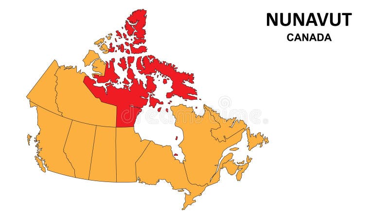
Free with trial Nunavut Map is highlighted on the Canada map with detailed state and region outlines n. Vancouver island map shape vectors Nunavut Map is highlighted on the Canada map with detailed state and region outlines
Free with trial Manitoba Map is highlighted on the Canada map with detailed state and region outlines n. Vancouver island map shape vectors Manitoba Map is highlighted on the Canada map with detailed state and region outlines
Free with trial Nova Scotia Map is highlighted on the Canada map with detailed state and region n outlines. Vancouver island map shape vectors Nova Scotia Map is highlighted on the Canada map with detailed state and region outlines
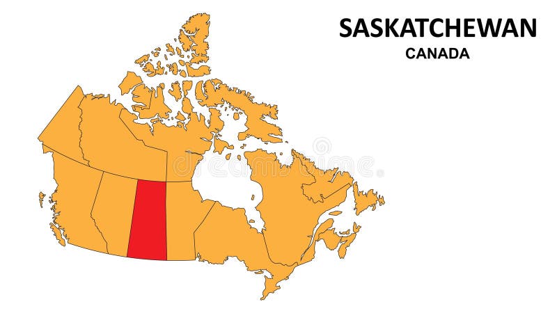
Free with trial Saskatchewan Map is highlighted on the Canada map with detailed state and region outlines. Vancouver island map shape vectors Saskatchewan Map is highlighted on the Canada map with detailed state and region outlines
Free with trial New Brunswick Map is highlighted on the Canada map with detailed state and region outlines n. Vancouver island map shape vectors New Brunswick Map is highlighted on the Canada map with detailed state and region outlines
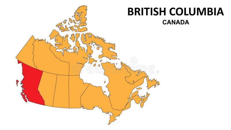
Free with trial British Columbia Map is highlighted on the Canada map with detailed state and region outlines n. Vancouver island map shape vectors British Columbia Map is highlighted on the Canada map with detailed state and region outlines
Free with trial Northwest Territories Map is highlighted on the Canada map with detailed state and region outlines n. Vancouver island map shape vectors Northwest Territories Map is highlighted on the Canada map with detailed state and region outlines
Free with trial Prince Edward islamd Map is highlighted on the Canada map with n detailed state and region outlines. Vancouver island map shape vectors Prince Edward islamd Map is highlighted on the Canada map with n detailed state and region outlines
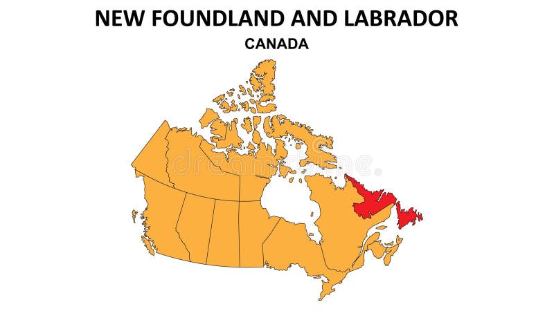
Free with trial New Foundland and Labrador Map is highlighted on the Canada map with detailed state and region outlines n. Vancouver island map shape vectors New Foundland and Labrador Map is highlighted on the Canada map with detailed state and region outlines
Free with trial A Saskatchewan Canada Province flag map with clipping path. Vancouver island map shape illustrations Saskatchewan Canada Province flag map
Free with trial The black and white maps of British Columbia province, Canada. Vancouver island map shape vectors British Columbia province maps. The black and white maps of British Columbia province, Canada
Free with trial Partial map of Nanaimo, Victoria, Tofino and Greater Vancouver. Canada, British Columbia. Touristic map. Simple map with little text. Shapes are optimized for better readability. Vancouver island map shape illustrations Map of Vancouver Island, blue and white. Partial map of Nanaimo, Victoria, Tofino and Greater Vancouver. Canada, British Columbia. Touristic map. Simple map with little text. Shapes are optimized for better readability
Free with trial Nova Scotia outline map Canada province region vector illustration. Vancouver island map shape vectors Nova Scotia outline map Canada province region
Free with trial The British Columbia province dark silhouette map isolated on white background, Canada. Vancouver island map shape illustrations British Columbia province dark silhouette map
Free with trial Nova Scotia outline map Canada province vector illustration. Vancouver island map shape vectors Nova Scotia outline map Canada province
Free with trial Nova Scotia state map typography art. Nova Scotia map lettering. Vancouver island map shape vectors Nova Scotia state map typography art. Nova Scotia map lettering
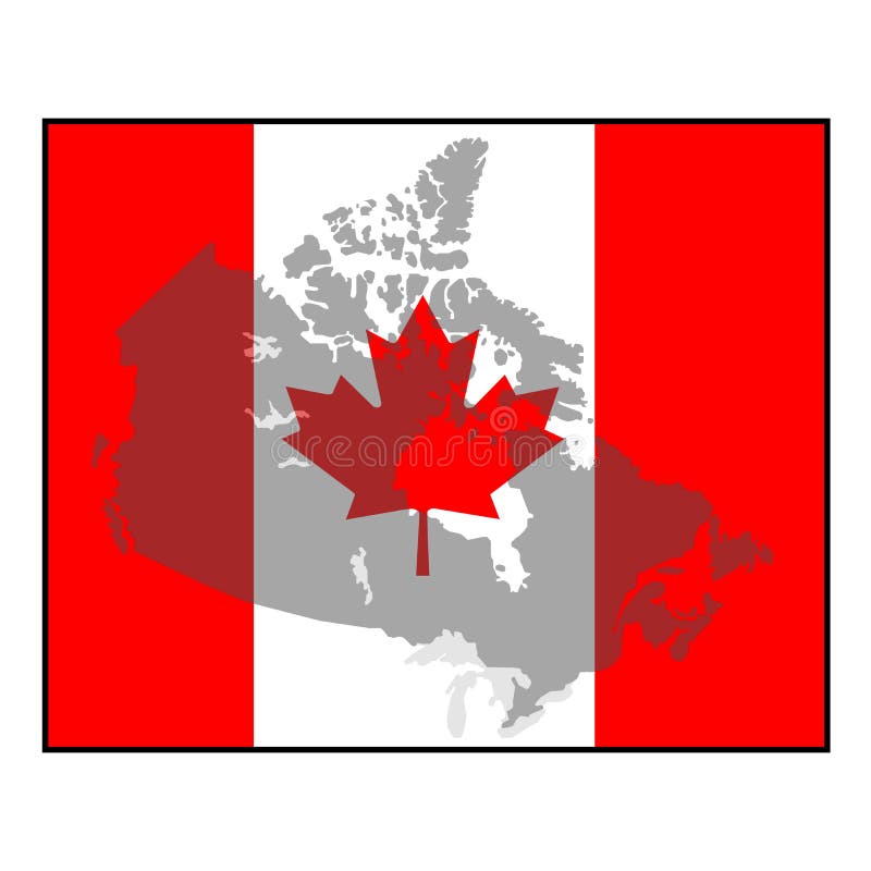
Free with trial Canada Map and Canada Flag. Canada map and Canada flag use for background drawing by illustration. Vancouver island map shape vectors Canada map and Canada Flag
Free with trial Map of Canada and Flag of Canada. Map of Canada and Flag of Canada drawing by illustration. Vancouver island map shape vectors Canada map and flag. Map of Canada and Flag of Canada. Map of Canada and Flag of Canada drawing by illustration.
Free with trial Canada Map and map icons flat stylized. Highly detailed map. Vancouver island map shape vectors Canada Map and map icons flat stylized
Free with trial A computer illustration of the blind map. This concept perfect to shown blank or blind place, maps, location, pointer icon for any purpose. Map isolated white background. Vancouver island map shape illustrations British Columbia blind map. A computer illustration of the blind map. This concept perfect to shown blank or blind place, maps, location, pointer icon for any purpose. Map isolated white background
Free with trial Canada flag red vector map on isolated white background with details. Vancouver island map shape illustrations Canada flag red vector map on isolated white background. Canada flag red vector map on isolated white background with details.
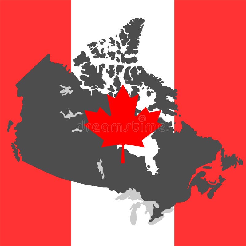
Free with trial Faded Canada Map background within a square Canadian maple leaf red and white flag. Vancouver island map shape vectors Canada Map on flag grey. Faded Canada Map background within a square Canadian maple leaf red and white flag
Free with trial Outlined Canada map country silhouette in national Canadian flag colors and with maple leaf vector drawing template for your design. Vancouver island map shape vectors Outlined Canada map country silhouette in national Canadian flag colors
Free with trial Canada country outline map on isolated white background details in north america. Vancouver island map shape vectors Canada country outline map on isolated white background. Canada country outline map on isolated white background details in north america.
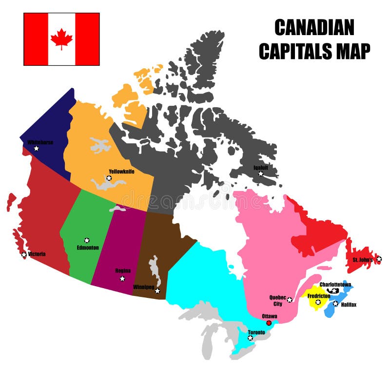
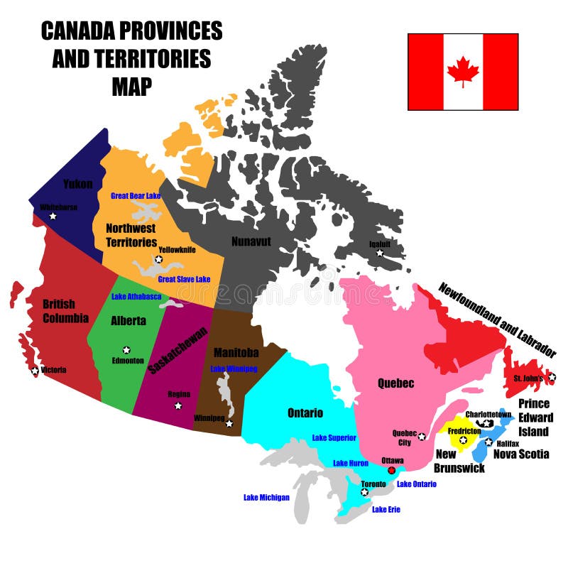
Free with trial Full Canada Vector Map of Provinces, Territories and Capitals in bright colors. Vancouver island map shape vectors Full Canada Vector Map of Provinces, Territories and Capitals in bright colors.
Free with trial Canada flag red vector map on isolated white background with a pin. Vancouver island map shape illustrations Canada flag red vector map on isolated white background. Canada flag red vector map on isolated white background with a pin
Free with trial Faded Canada Map background within a square Canadian maple leaf red and white flag. Vancouver island map shape vectors Faded Canada Map background within a square Canadian maple leaf red and white flag
Free with trial Canada country grey vector map on isolated white background for travel, and geography concepts. Vancouver island map shape illustrations Canada country grey vector map on isolated white background for travel, and geography concepts.
Free with trial Canada Maple Leaf Red and White Flag in wide circle. Vancouver island map shape vectors Canada Maple Leaf Red and White Flag in wide circle.
Free with trial Canada Maple Leaf Red and White Flag in wide rectangle. Vancouver island map shape illustrations Canada Maple Leaf Red and White Flag in wide rectangle.
Free with trial Canada Maple Leaf Flag 3D Red and White Flag in wide circle and rectangle Icon Set. Vancouver island map shape vectors Canada Maple Leaf Flag 3D Red and White Flag in wide circle and rectangle Icon Set.