Free with trial Netherlands high detailed local municipalities map colored by provinces. All elements are separated in detachable and labeled layers. Venlo map vectors Netherlands high detailed local municipalities map colored by provinces
Free with trial Detailed navigation black lines urban street roads map of the Dutch regional capital city of VENLO, NETHERLANDS on vintage beige background. Venlo map vectors Street roads map of VENLO, NETHERLANDS. Detailed navigation black lines urban street roads map of the Dutch regional capital city of VENLO, NETHERLANDS on vintage beige background
Free with trial Kreis Viersen. Administrative area of Germany on a Topographic Standard style map. Venlo map illustrations Kreis Viersen, Germany. Topographic Standard. Kreis Viersen. Administrative area of Germany on a Topographic Standard style map
Free with trial Discover a vintage map of Venlo, a historic city in the province of Limburg, Netherlands. Located along the Meuse River (Maas) near the German border, Venlo has long been an important trading and transport hub in the southeastern Netherlands. Venlo map illustrations . Discover a vintage map of Venlo, a historic city in the province of Limburg, Netherlands. Located along the Meuse River (Maas) near the German border, Venlo has long been an important trading and transport hub in the southeastern Netherlands.
Free with trial Venlo blank outline map set. Venlo map vectors Venlo outline map. Venlo blank outline map set
Free with trial Colorful Venlo Art Map with Labels and Buildings with many details for urban roads, paths and disctricts. Venlo map illustrations Colorful Venlo Street Map with Labels and Buildings. Colorful Venlo Art Map with Labels and Buildings with many details for urban roads, paths and disctricts
Free with trial Venlo vector minimalist street plan map of a Dutch city on a dark gray round background. Netherlands. Venlo map vectors Venlo vector minimalist street plan map of a Dutch city on a dark gray round background.
Free with trial Printable downtown road map poster of the Dutch city of VENLO on solid white background with city name. Venlo map vectors Poster print road map of the Dutch town of VENLO. Printable downtown road map poster of the Dutch city of VENLO on solid white background with city name
Free with trial Venlo city and municipality (Kingdom of the Netherlands, Holland, Limburg province) map vector illustration, scribble sketch Venlo map. Venlo map vectors Venlo city and municipality (Kingdom of the Netherlands, Holland, Limburg province)
Free with trial Kreis Kleve. Administrative area of Germany outlined on a Topographic Humanitarian style map. Venlo map illustrations Kreis Kleve outlined, Germany. Topographic Humanitarian. Kreis Kleve. Administrative area of Germany outlined on a Topographic Humanitarian style map
Free with trial Kreis Viersen. Administrative area of Germany outlined on a Topographic Humanitarian style map. Venlo map illustrations Kreis Viersen outlined, Germany. Topographic Humanitarian. Kreis Viersen. Administrative area of Germany outlined on a Topographic Humanitarian style map
Free with trial Kreis Viersen. Administrative area of Germany highlighted and outlined on a darkened Topographic Humanitarian style map. Venlo map illustrations Kreis Viersen highlighted, Germany. Topographic Humanitarian. Kreis Viersen. Administrative area of Germany highlighted and outlined on a darkened Topographic Humanitarian style map
Free with trial Kreis Kleve. Administrative area of Germany isolated on white on a Topographic Humanitarian style map. Venlo map illustrations Kreis Kleve, Germany, isolated on white. Topographic Humanitarian. Kreis Kleve. Administrative area of Germany isolated on white on a Topographic Humanitarian style map
Free with trial Kreis Kleve. Administrative area of Germany on a Topographic Humanitarian style map. Venlo map illustrations Kreis Kleve, Germany. Topographic Humanitarian. Kreis Kleve. Administrative area of Germany on a Topographic Humanitarian style map
Free with trial Kreis Viersen. Administrative area of Germany on a Topographic Humanitarian style map. Venlo map illustrations Kreis Viersen, Germany. Topographic Humanitarian. Kreis Viersen. Administrative area of Germany on a Topographic Humanitarian style map
Free with trial Kreis Kleve. Administrative area of Germany outlined on a colored elevation map. Venlo map illustrations Kreis Kleve outlined, Germany. Physical. Kreis Kleve. Administrative area of Germany outlined on a colored elevation map
Free with trial Kreis Kleve. Administrative area of Germany outlined on a grayscale elevation map. Venlo map illustrations Kreis Kleve outlined, Germany. Grayscale. Kreis Kleve. Administrative area of Germany outlined on a grayscale elevation map
Free with trial Kreis Viersen. Administrative area of Germany outlined on a colored elevation map. Venlo map illustrations Kreis Viersen outlined, Germany. Physical. Kreis Viersen. Administrative area of Germany outlined on a colored elevation map
Free with trial Kreis Kleve. Administrative area of Germany highlighted and outlined on a darkened colored elevation map. Venlo map illustrations Kreis Kleve highlighted, Germany. Physical. Kreis Kleve. Administrative area of Germany highlighted and outlined on a darkened colored elevation map
Free with trial Kreis Viersen. Administrative area of Germany outlined on a grayscale elevation map. Venlo map illustrations Kreis Viersen outlined, Germany. Grayscale. Kreis Viersen. Administrative area of Germany outlined on a grayscale elevation map
Free with trial Kreis Kleve. Administrative area of Germany highlighted and outlined on a darkened grayscale elevation map. Venlo map illustrations Kreis Kleve highlighted, Germany. Grayscale. Kreis Kleve. Administrative area of Germany highlighted and outlined on a darkened grayscale elevation map
Free with trial Kreis Viersen. Administrative area of Germany highlighted and outlined on a darkened colored elevation map. Venlo map illustrations Kreis Viersen highlighted, Germany. Physical. Kreis Viersen. Administrative area of Germany highlighted and outlined on a darkened colored elevation map
Free with trial Kreis Viersen. Administrative area of Germany highlighted and outlined on a darkened grayscale elevation map. Venlo map illustrations Kreis Viersen highlighted, Germany. Grayscale. Kreis Viersen. Administrative area of Germany highlighted and outlined on a darkened grayscale elevation map
Free with trial Kreis Kleve. Administrative area of Germany isolated on white on a colored elevation map. Venlo map illustrations Kreis Kleve, Germany, isolated on white. Physical. Kreis Kleve. Administrative area of Germany isolated on white on a colored elevation map
Free with trial Kreis Kleve. Administrative area of Germany isolated on white on a grayscale elevation map. Venlo map illustrations Kreis Kleve, Germany, isolated on white. Grayscale. Kreis Kleve. Administrative area of Germany isolated on white on a grayscale elevation map
Free with trial Kreis Viersen. Administrative area of Germany isolated on white on a colored elevation map. Venlo map illustrations Kreis Viersen, Germany, isolated on white. Physical. Kreis Viersen. Administrative area of Germany isolated on white on a colored elevation map
Free with trial Kreis Viersen. Administrative area of Germany isolated on white on a grayscale elevation map. Venlo map illustrations Kreis Viersen, Germany, isolated on white. Grayscale. Kreis Viersen. Administrative area of Germany isolated on white on a grayscale elevation map
Free with trial Kreis Kleve. Administrative area of Germany outlined on a Topographic Standard style map. Venlo map illustrations Kreis Kleve outlined, Germany. Topographic Standard. Kreis Kleve. Administrative area of Germany outlined on a Topographic Standard style map
Free with trial Kreis Viersen. Administrative area of Germany outlined on a Topographic Standard style map. Venlo map illustrations Kreis Viersen outlined, Germany. Topographic Standard. Kreis Viersen. Administrative area of Germany outlined on a Topographic Standard style map
Free with trial Kreis Kleve. Administrative area of Germany highlighted and outlined on a darkened Topographic Standard style map. Venlo map illustrations Kreis Kleve highlighted, Germany. Topographic Standard. Kreis Kleve. Administrative area of Germany highlighted and outlined on a darkened Topographic Standard style map
Free with trial Kreis Viersen. Administrative area of Germany highlighted and outlined on a darkened Topographic Standard style map. Venlo map illustrations Kreis Viersen highlighted, Germany. Topographic Standard. Kreis Viersen. Administrative area of Germany highlighted and outlined on a darkened Topographic Standard style map
Free with trial Kreis Kleve. Administrative area of Germany highlighted and outlined on a darkened Topographic Humanitarian style map. Venlo map illustrations Kreis Kleve highlighted, Germany. Topographic Humanitarian. Kreis Kleve. Administrative area of Germany highlighted and outlined on a darkened Topographic Humanitarian style map
Free with trial Kreis Kleve. Administrative area of Germany isolated on white on a Topographic Standard style map. Venlo map illustrations Kreis Kleve, Germany, isolated on white. Topographic Standard. Kreis Kleve. Administrative area of Germany isolated on white on a Topographic Standard style map
Free with trial Kreis Viersen. Administrative area of Germany isolated on white on a Topographic Standard style map. Venlo map illustrations Kreis Viersen, Germany, isolated on white. Topographic Standard. Kreis Viersen. Administrative area of Germany isolated on white on a Topographic Standard style map
Free with trial Horst aan de Maas. Administrative area of Netherlands outlined on a Topographic Humanitarian style map. Venlo map illustrations Horst aan de Maas outlined, Netherlands. Topographic Humanitarian. Horst aan de Maas. Administrative area of Netherlands outlined on a Topographic Humanitarian style map
Free with trial Kreis Viersen. Administrative area of Germany isolated on white on a Topographic Humanitarian style map. Venlo map illustrations Kreis Viersen, Germany, isolated on white. Topographic Humanitarian. Kreis Viersen. Administrative area of Germany isolated on white on a Topographic Humanitarian style map
Free with trial Horst aan de Maas. Administrative area of Netherlands highlighted and outlined on a darkened Topographic Humanitarian style map. Venlo map illustrations Horst aan de Maas highlighted, Netherlands. Topographic Humanitarian. Horst aan de Maas. Administrative area of Netherlands highlighted and outlined on a darkened Topographic Humanitarian style map
Free with trial Horst aan de Maas. Administrative area of Netherlands isolated on white on a Topographic Humanitarian style map. Venlo map illustrations Horst aan de Maas, Netherlands, isolated on white. Topographic Humanitarian. Horst aan de Maas. Administrative area of Netherlands isolated on white on a Topographic Humanitarian style map
Free with trial Kreis Kleve. Administrative area of Germany on a Topographic Standard style map. Venlo map illustrations Kreis Kleve, Germany. Topographic Standard. Kreis Kleve. Administrative area of Germany on a Topographic Standard style map
Free with trial Horst aan de Maas. Administrative area of Netherlands on a Topographic Humanitarian style map. Venlo map illustrations Horst aan de Maas, Netherlands. Topographic Humanitarian. Horst aan de Maas. Administrative area of Netherlands on a Topographic Humanitarian style map
Free with trial Limburg flag, Netherlands, waving in the wind. 3d illustration. Venlo map illustrations Limburg flag, Netherlands, waving in the wind. 3d illustration
Free with trial Venlo City Kingdom of the Netherlands, Limburg, Holland map vector illustration, scribble sketch City of Venlo map,. Venlo map vectors Venlo City Kingdom of the Netherlands, Limburg, Holland map vector illustration, scribble sketch City of Venlo map
Free with trial Black city map of Venlo Netherlands with white roads. Venlo map illustrations Black city map of Venlo Netherlands. Black city map of Venlo Netherlands with white roads.
Free with trial Venlo City Kingdom of the Netherlands, Limburg, Holland map vector illustration, scribble sketch City of Venlo map,. Venlo map vectors Venlo City Kingdom of the Netherlands, Limburg, Holland map vector illustration, scribble sketch City of Venlo map
Free with trial Venlo City Kingdom of the Netherlands, Limburg, Holland map vector illustration, scribble sketch City of Venlo map,. Venlo map vectors Venlo City Kingdom of the Netherlands, Limburg, Holland map vector illustration, scribble sketch City of Venlo map
Free with trial Black flat blank vector map of the Dutch regional capital city of VENLO, NETHERLANDS. Venlo map vectors Black map of VENLO, NETHERLANDS. Black flat blank vector map of the Dutch regional capital city of VENLO, NETHERLANDS
Free with trial Black flat blank highlighted location map of the TEGELEN DISTRICT inside gray administrative map of Venlo, Netherlands. Venlo map vectors Locator map of the TEGELEN DISTRICT, VENLO. Black flat blank highlighted location map of the TEGELEN DISTRICT inside gray administrative map of Venlo, Netherlands
Free with trial Black flat blank highlighted location map of the BLERICK-STAD DISTRICT inside gray administrative map of Venlo, Netherlands. Venlo map vectors Locator map of the BLERICK-STAD DISTRICT, VENLO. Black flat blank highlighted location map of the BLERICK-STAD DISTRICT inside gray administrative map of Venlo, Netherlands
Free with trial Black flat blank highlighted location map of the GELOO-BELFELD DISTRICT inside gray administrative map of Venlo, Netherlands. Venlo map vectors Locator map of the GELOO-BELFELD DISTRICT, VENLO. Black flat blank highlighted location map of the GELOO-BELFELD DISTRICT inside gray administrative map of Venlo, Netherlands
Free with trial White flat vector administrative map of VENLO, NETHERLANDS with name tags and black border lines of its districts. Venlo map vectors White tagged districts map of VENLO, NETHERLANDS. White flat vector administrative map of VENLO, NETHERLANDS with name tags and black border lines of its districts
Free with trial Pastel flat vector administrative map of VENLO, NETHERLANDS with name tags and black border lines of its districts. Venlo map vectors Pastel tagged districts map of VENLO, NETHERLANDS. Pastel flat vector administrative map of VENLO, NETHERLANDS with name tags and black border lines of its districts
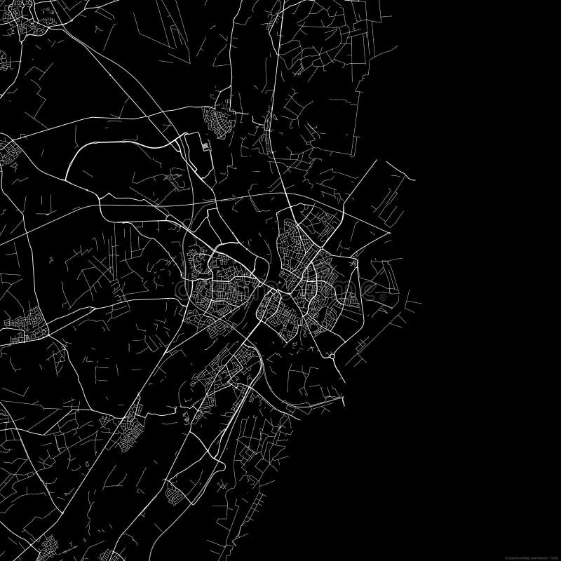
Free with trial Detailed negative navigation white lines urban street roads map of the Dutch regional capital city of VENLO, NETHERLANDS on dark gray background. Venlo map vectors Street roads map of VENLO, NETHERLANDS. Detailed negative navigation white lines urban street roads map of the Dutch regional capital city of VENLO, NETHERLANDS on dark gray background
Free with trial Dark gray flat vector administrative map of VENLO, NETHERLANDS with name tags and white border lines of its districts. Venlo map vectors Dark gray tagged districts map of VENLO, NETHERLANDS. Dark gray flat vector administrative map of VENLO, NETHERLANDS with name tags and white border lines of its districts
Free with trial Black flat blank highlighted location map of the VENLO-STAD DISTRICT inside gray administrative map of Venlo, Netherlands. Venlo map vectors Locator map of the VENLO-STAD DISTRICT, VENLO. Black flat blank highlighted location map of the VENLO-STAD DISTRICT inside gray administrative map of Venlo, Netherlands
Free with trial Black flat blank highlighted location map of the BLERICK-RANDGEBIED DISTRICT inside gray administrative map of Venlo, Netherlands. Venlo map vectors Locator map of the BLERICK-RANDGEBIED DISTRICT, VENLO. Black flat blank highlighted location map of the BLERICK-RANDGEBIED DISTRICT inside gray administrative map of Venlo, Netherlands
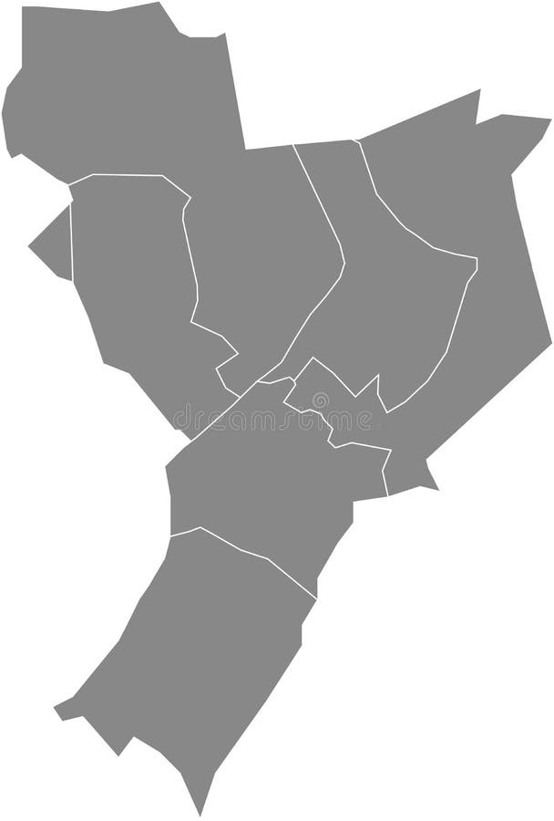
Free with trial Gray flat blank vector administrative map of VENLO, NETHERLANDS with black border lines of its districts. Venlo map vectors Gray districts map of VENLO, NETHERLANDS. Gray flat blank vector administrative map of VENLO, NETHERLANDS with black border lines of its districts
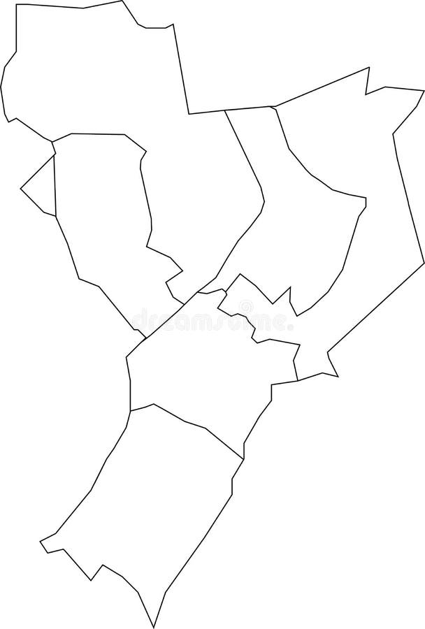
Free with trial White flat blank vector administrative map of VENLO, NETHERLANDS with black border lines of its districts. Venlo map vectors White districts map of VENLO, NETHERLANDS. White flat blank vector administrative map of VENLO, NETHERLANDS with black border lines of its districts
Free with trial Gray flat blank vector map of the Dutch regional capital city of VENLO, NETHERLANDS. Venlo map vectors Gray map of VENLO, NETHERLANDS. Gray flat blank vector map of the Dutch regional capital city of VENLO, NETHERLANDS
Free with trial Topographic negative relief map of the city of VENLO, NETHERLANDS with white contour lines on dark gray background. Venlo map vectors Topographic relief map of VENLO, NETHERLANDS. Topographic negative relief map of the city of VENLO, NETHERLANDS with white contour lines on dark gray background
Free with trial Topographic relief map of the city of VENLO, NETHERLANDS with black contour lines on vintage beige background. Venlo map vectors Topographic relief map of VENLO, NETHERLANDS. Topographic relief map of the city of VENLO, NETHERLANDS with black contour lines on vintage beige background
Free with trial Black flat blank highlighted location map of the VENLO-RANDGEBIED DISTRICT inside gray administrative map of Venlo, Netherlands. Venlo map vectors Locator map of the VENLO-RANDGEBIED DISTRICT, VENLO. Black flat blank highlighted location map of the VENLO-RANDGEBIED DISTRICT inside gray administrative map of Venlo, Netherlands
Free with trial Venlo city and municipality (Kingdom of the Netherlands, Holland, Limburg province) map vector illustration, scribble sketch Venlo map. Venlo map vectors Venlo city and municipality (Kingdom of the Netherlands, Holland, Limburg province)
Free with trial Venlo city and municipality (Kingdom of the Netherlands, Holland, Limburg province) map vector illustration, scribble sketch Venlo map. Venlo map vectors Venlo city and municipality
Free with trial Map of the Netherlands with administrative divisions of the country into regional groups of provinces, detailed vector illustration, for your design. Venlo map vectors Map of the Netherlands with administrative divisions of the country into regional groups of provinces, detailed vector
Free with trial Netherlands municipalities isometric map with neighbouring countries. Vector illustration. Venlo map vectors Netherlands municipalities isometric map with neighbouring countries
Free with trial 3D Illustration of a waving Holand city flag of Venlo Netherlands country. Venlo map illustrations 3D Waving Netherlands City Flag of Venlo Closeup View. 3D Illustration of a waving Holand city flag of Venlo Netherlands country
Free with trial 3D Illustration of a waving Holand city flag of Venlo Netherlands country. Venlo map illustrations 3D Waving Netherlands City Flag of Venlo Closeup View. 3D Illustration of a waving Holand city flag of Venlo Netherlands country
Free with trial Official flag vector illustration of the Dutch regional capital city of VENLO, NETHERLANDS. Venlo map vectors Flag of VENLO, NETHERLANDS. Official flag vector illustration of the Dutch regional capital city of VENLO, NETHERLANDS
Free with trial Official coat of arms vector illustration of the Dutch regional capital city of VENLO, NETHERLANDS. Venlo map vectors Coat of arms of VENLO, NETHERLANDS. Official coat of arms vector illustration of the Dutch regional capital city of VENLO, NETHERLANDS