Free with trial Highly detailed map of China with all different regions and main cities. Vietnam province vectors Political map of China. Highly detailed map of China with all different regions and main cities
Free with trial Combodia map designed in illustration with the provinces and the main cities. Vietnam province vectors Combodia map
Free with trial Set of the political Indonesia maps, markers and symbols for infographic. Vietnam province vectors Indonesia maps with markers. Set of the political Indonesia maps, markers and symbols for infographic
Free with trial Flag of Vietnam officially the Socialist Republic of Vietnam. Vector illustration. Vietnam province vectors Flag of Vietnam
Free with trial Combodia map designed in illustration with the provinces and the main cities. Vietnam province vectors Map of Combodia. Combodia map designed in illustration with the provinces and the main cities.
Free with trial WPA poster art of the Ha Long Bay or Halong Bay in Quang Ninh Province, Vietnam done in works project administration or federal art project style. Vietnam province vectors Ha Long Bay or Halong Bay in Quang Ninh Province Vietnam WPA Poster Art Color. WPA poster art of the Ha Long Bay or Halong Bay in Quang Ninh Province, Vietnam done in works project administration or federal art project style
Free with trial High Quality map of Bac Giang is a province of Vietnam. Vietnam province illustrations Map of province of Vietnam. High Quality map of Bac Giang is a province of Vietnam
Free with trial High Quality map of Soc Trang is a province of Vietnam. Vietnam province illustrations Map of province of Vietnam. High Quality map of Soc Trang is a province of Vietnam
Free with trial 3d isometric map of Binh Duong Province of Vietnam, vector illustration. Vietnam province vectors 3d isometric map of Binh Duong Province of Vietnam
Free with trial Shape of Hà Giang, province of Vietnam, with its capital isolated on white background. Satellite imagery. 3D rendering. Vietnam province illustrations Hà Giang, province of Vietnam, on white. Satellite. Shape of Hà Giang, province of Vietnam, with its capital isolated on white background. Satellite imagery. 3D rendering
Free with trial 3d isometric map of Ha Giang Province of Vietnam, vector illustration. Vietnam province vectors 3d isometric map of Ha Giang Province of Vietnam
Free with trial Blank map Khanh Hoa Province of Vietnam. High quality map Khanh Hoa with districts on transparent background for your web site design, logo, app, UI. Vietnam. EPS10. Vietnam province vectors Blank map Khanh Hoa Province of Vietnam. High quality map Khanh Hoa with districts on transparent background
Free with trial 3d isometric map of Kien Giang Province of Vietnam, vector illustration. Vietnam province vectors 3d isometric map of Kien Giang Province of Vietnam
Free with trial WPA poster art of Ha Long Bay or Halong Bay with boat vendor during sunset located in Quang Ninh Province in Vietnam done in works project administration or Art Deco style. Vietnam province vectors Ha Long Bay or Halong Bay with Boat Vendor Vietnam WPA Art Deco Poster. WPA poster art of Ha Long Bay or Halong Bay with boat vendor during sunset located in Quang Ninh Province in Vietnam done in works project administration or Art Deco style.
Free with trial Kien Giang Province Socialist Republic of Vietnam, Subdivisions of Vietnam map vector illustration, scribble sketch Tinh Kien Giang map. Vietnam province vectors Kien Giang Province map vector. Kien Giang Province Socialist Republic of Vietnam, Subdivisions of Vietnam map vector illustration, scribble sketch Tinh Kien Giang map
Free with trial Trà Vinh - province of Vietnam zoomed and highlighted. Satellite imagery. 3D rendering. Vietnam province illustrations Trà Vinh, Vietnam - highlighted. Satellite. Trà Vinh - province of Vietnam zoomed and highlighted. Satellite imagery. 3D rendering
Free with trial Dak Lak Province Socialist Republic of Vietnam, Subdivisions of Vietnam map vector illustration, scribble sketch Tinh Dac Nong map. Vietnam province vectors Dak Lak Province map vector. Dak Lak Province Socialist Republic of Vietnam, Subdivisions of Vietnam map vector illustration, scribble sketch Tinh Dac Nong map
Free with trial Zoom in on Kiên Giang (province of Vietnam) extruded. Oblique perspective. Topographic relief map with surface waters. 3D rendering. Vietnam province illustrations Kiên Giang, Vietnam - extruded with capital. Relief. Zoom in on Kiên Giang (province of Vietnam) extruded. Oblique perspective. Topographic relief map with surface waters. 3D rendering
Free with trial Trà Vinh, province of Vietnam. Satellite imagery. Shape presented against its country area with informative overlays. 3D rendering. Vietnam province illustrations Trà Vinh, Vietnam - composition. Satellite. Trà Vinh, province of Vietnam. Satellite imagery. Shape presented against its country area with informative overlays. 3D rendering
Free with trial Zoom in on Bình Định (province of Vietnam) outlined. Oblique perspective. Topographic relief map with surface waters. 3D rendering. Vietnam province illustrations Bình Định, Vietnam - outlined. Relief. Zoom in on Bình Định (province of Vietnam) outlined. Oblique perspective. Topographic relief map with surface waters. 3D rendering
Free with trial Binh inh, province of Vietnam. Sentinel-2 satellite imagery. Shape isolated on white. Description, location of the capital. Contains modified Copernicus Sentinel data. Vietnam province illustrations Binh inh, Vietnam - white solid. Sentinel-2 satellite. Binh inh, province of Vietnam. Sentinel-2 satellite imagery. Shape isolated on white. Description, location of the capital. Contains modified Copernicus Sentinel data
Free with trial The majestic terraced fields in Ha Giang province, Vietnam. Rice fields ready to be harvested. Generate Ai. Vietnam province illustrations The majestic terraced fields in Ha Giang province, Vietnam. Rice fields ready to be harvested
Free with trial Ha Giang, province of Vietnam. Sentinel-2 satellite imagery. Shape isolated on white. Description, location of the capital. Contains modified Copernicus Sentinel data. Vietnam province illustrations Ha Giang, Vietnam - white solid. Sentinel-2 satellite. Ha Giang, province of Vietnam. Sentinel-2 satellite imagery. Shape isolated on white. Description, location of the capital. Contains modified Copernicus Sentinel data
Free with trial Socialist Republic of Vietnam road vector map. Vietnam province vectors Socialist Republic of Vietnam road vector map
Free with trial Hainan,southernmost province of China,and surrounding area,gray political map. Hainan Island,and Paracel Islands in the South China Sea,south of the Leizhou Peninsula,and east of Gulf of Tonkin. Vietnam province vectors Hainan, a province of China, and Paracel Islands, gray political map. Hainan,southernmost province of China,and surrounding area,gray political map. Hainan Island,and Paracel Islands in the South China Sea,south of the Leizhou Peninsula,and east of Gulf of Tonkin.
Free with trial Hainan,southernmost province of China,and surrounding area,political map. Hainan Island,and the Paracel Islands,in the South China Sea,south of the Leizhou Peninsula,and east of Gulf of Tonkin. Vietnam province vectors Hainan, a province of China, and the Paracel Islands, political map. Hainan,southernmost province of China,and surrounding area,political map. Hainan Island,and the Paracel Islands,in the South China Sea,south of the Leizhou Peninsula,and east of Gulf of Tonkin.
Free with trial A panoramic view of the lush green terraces in Pu Luong, Vietnam, showcasing stunning natural beauty and vibrant landscapes. Vietnam province illustrations Panoramic view of beautiful green terraces of Pu Luong commune, Thanh Hoa province, Vietnam. A panoramic view of the lush green terraces in Pu Luong, Vietnam, showcasing stunning natural beauty and vibrant landscapes
Free with trial Vector cartoon Vietnam map icon in comic style. Vietnam sign illustration pictogram. Cartography map business splash effect concept. Vietnam province vectors Vector cartoon Vietnam map icon in comic style. Vietnam sign ill
Free with trial Vietnam map outline country shape national borders state vector illustration. Vietnam province vectors Vietnam map outline country shape national borders state
Free with trial Binh Duong region highlighted in red on a grey Vietnam 3d map. Vietnam province vectors Binh Duong region location within Vietnam 3d map. Binh Duong region highlighted in red on a grey Vietnam 3d map
Free with trial Outline Bien Hoa Vietnam City Skyline with Blue Buildings and Reflections. Vector Illustration. Business Travel and Tourism Concept with Historic Architecture. Bien Hoa Cityscape with Landmarks. Vietnam province vectors Outline Bien Hoa Vietnam City Skyline with Blue Buildings and Reflections
Free with trial Northern Vietnam region location within Vietnam 3d isometric map. Vietnam province vectors Northern Vietnam region location within Vietnam map. Northern Vietnam region location within Vietnam 3d isometric map
Free with trial Central Vietnam region location within Vietnam 3d isometric map. Vietnam province vectors Central Vietnam region location within Vietnam map. Central Vietnam region location within Vietnam 3d isometric map
Free with trial Southern Vietnam region location within Vietnam 3d isometric map. Vietnam province vectors Southern Vietnam region location within Vietnam map. Southern Vietnam region location within Vietnam 3d isometric map
Free with trial Thanh Hoa region highlighted in red on a grey Vietnam 3d map. Vietnam province vectors Thanh Hoa region location within Vietnam 3d map. Thanh Hoa region highlighted in red on a grey Vietnam 3d map
Free with trial High quality political map of Vietnam,Cambodia and Laos with borders of the regions or provinces. Vector illustration. Vietnam province vectors High quality political map of Vietnam,Cambodia and Laos with borders of the regions or provinces.
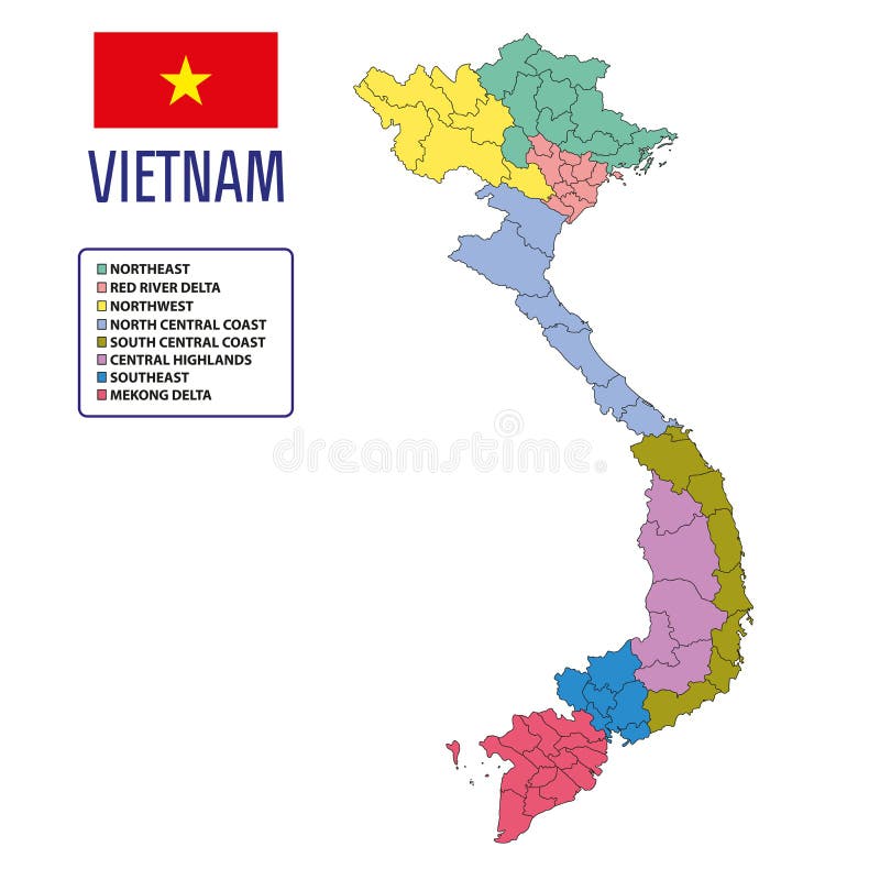
Free with trial Vietnam Map Flag with the name of all province. Vietnam province illustrations Vietnam Map Flag
Free with trial Vietnam world map in flat style with 4 colors. Modern map design. Vietnam province vectors Vietnam world map in flat style with 4 colors.
Free with trial Socialist Republic of Vietnam road vector map with flag. Vietnam province vectors Socialist Republic of Vietnam road vector map with flag
Free with trial Vietnam administrative and political vector map with flag. Vietnam province vectors Vietnam administrative and political vector map with flag
Free with trial Vector highly detailed political map of Vietnam with regions and their capitals. All elements are separated in editable layers clearly labeled. EPS 10. Vietnam province vectors Vietnam political vector map with regions. Vector highly detailed political map of Vietnam with regions and their capitals. All elements are separated in editable layers clearly labeled. EPS 10
Free with trial Vector highly detailed political map of Vietnam with regions and their capitals. All elements are separated in editable layers clearly labeled. EPS 10. Vietnam province vectors Vietnam vector map with regions. Vector highly detailed political map of Vietnam with regions and their capitals. All elements are separated in editable layers clearly labeled. EPS 10
Free with trial Flag Map of Vietnam officially the Socialist Republic of Vietnam. Vector illustration eps 10. Vietnam province vectors Flag Map of Vietnam officially the Socialist Republic of Vietnam. Vector illustration
Free with trial Vietnam map flag isolated on png or transparent background vector illustration. Vietnam province vectors Vietnam map flag isolated on png or transparent background vector illustration
Free with trial Waving Vietnam Flag Isolated On A White Background. Vector Illustration. Official Colors And Proportion. Independence Day. Vietnam province vectors Waving Vietnam Flag Isolated On A White Background. Vector Illustration
Free with trial The bronze drum with Taotie (a mythical ferocious animal) patterns, a bronze ware made in the Shang Dynasty, was excavated in Hubei Province and is now preserved in Hubei Provincial Museum. It is one of the only two bronze drums made in the Shang Dynasty that still exist in the world. Vietnam province illustrations The bronze drum with Taotie patterns. The bronze drum with Taotie (a mythical ferocious animal) patterns, a bronze ware made in the Shang Dynasty, was excavated in Hubei Province and is now preserved in Hubei Provincial Museum. It is one of the only two bronze drums made in the Shang Dynasty that still exist in the world.
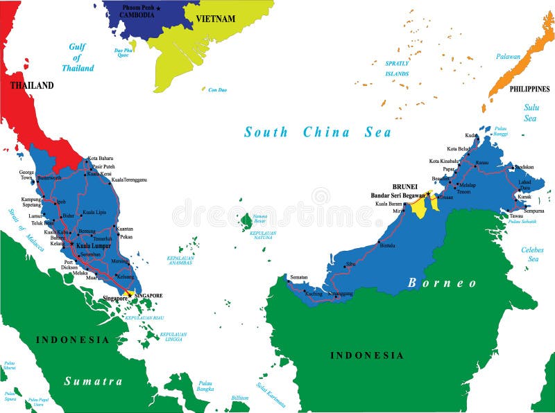
Free with trial Highly detailed vector map of Malaysia with main cities and roads. Vietnam province vectors Malaysia map. Highly detailed vector map of Malaysia with main cities and roads.
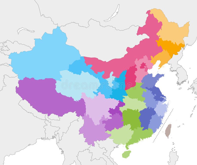
Free with trial Vector map of China provinces colored by regions with neighbouring countries and territories. Vietnam province vectors Vector map of China provinces colored by regions with neighbouring countries and territories
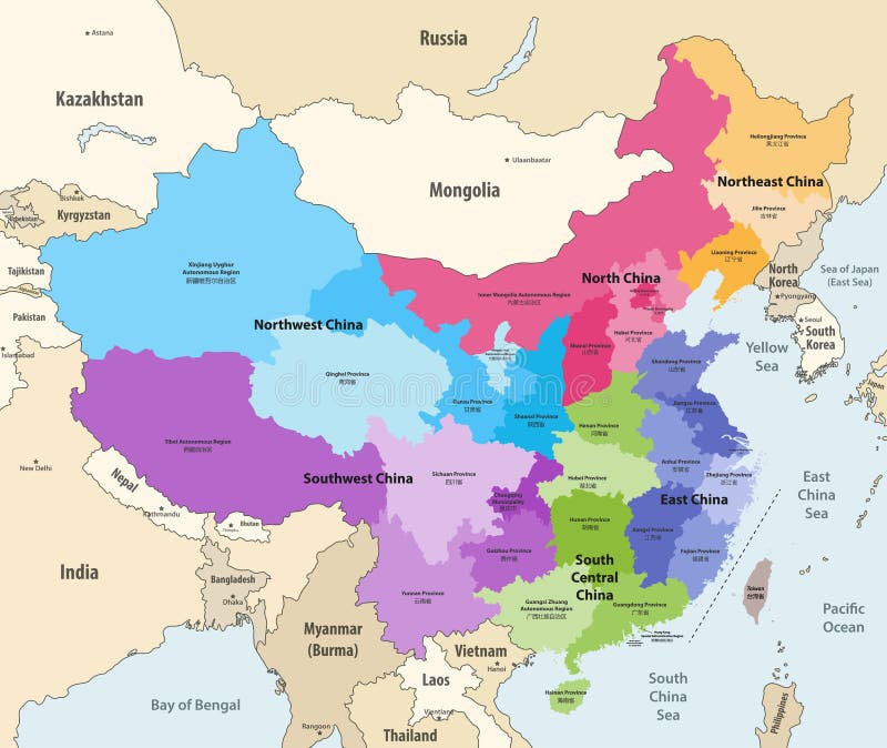
Free with trial Vector map of China provinces chinese names gives in parentheses colored by regions with neighbouring countries and territories. Vietnam province vectors Vector map of China provinces colored by regions with neighbouring countries and territories. Vector map of China provinces chinese names gives in parentheses colored by regions with neighbouring countries and territories
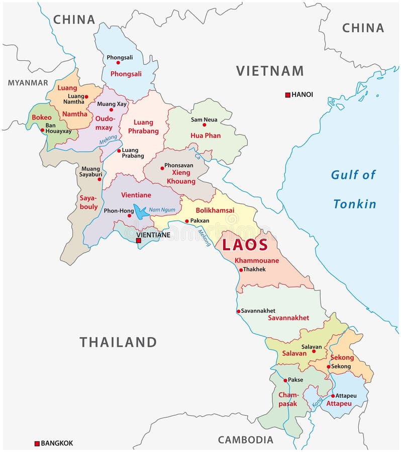
Free with trial Laos administrative and political vector map. Vietnam province vectors Laos administrative and political vector map
Free with trial Thailand famous outline landmarks. Hand-drawn vector illustration. Famous travel destinations series. Vietnam province vectors Thailand famous outline landmarks
Free with trial Map and flag of Thailand. Vietnam province vectors Map of Thailand. Map and flag of Thailand
Free with trial Political vector map of Thailand with all regions and their capitals. Vietnam province vectors Political vector map of Thailand
Free with trial Political vector map of Thailand with all regions and their capitals. Vietnam province vectors Map of Thailand
Free with trial Political vector map of Thailand with all regions and their capitals. Vietnam province vectors Map of Thailand
Free with trial Political vector map of Thailand with all regions and their capitals. Vietnam province vectors Map of Thailand
Free with trial Vector illustration of the Combined Map and Flag of South Korea. Vietnam province vectors Combined Map and Flag of South Korea
Free with trial Lao Peoples Democratic Republic administrative vector map. Vietnam province vectors Lao Peoples Democratic Republic administrative vector map
Free with trial Vector illustration of the Red map of the Middle East. Vietnam province vectors Red map of the Middle East
Free with trial Malaysia map, black and white detailed outline regions of the country. Vector illustration. Vietnam province vectors Malaysia map, black and white detailed outline regions of the country.
Free with trial Vector illustration of the Round flag of China. Vietnam province vectors Round flag of China
Free with trial Vector illustration of the Black map of Egypt. Vietnam province vectors Black Map of Hong Egypt. Vector illustration of the Black map of Egypt
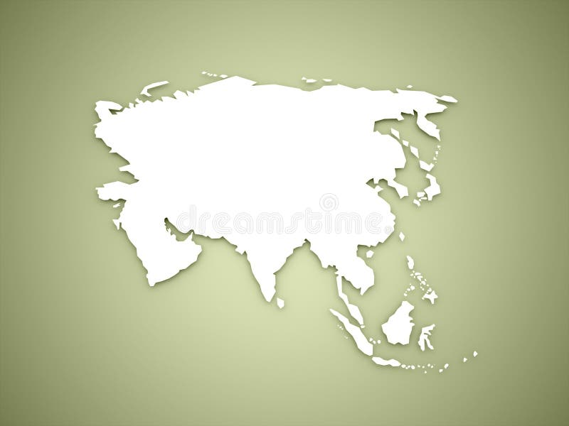
Free with trial Asia map continent concept on green background. Vietnam province illustrations Asia map continent concept on green
Free with trial Thailand map, black and white detailed outline regions of the country. Vector illustration. Vietnam province illustrations Thailand map, black and white detailed outline regions of the country
Free with trial A very detailed map of the country of Syria colored with the most important rivers, lakes, seas in blue and forests in green, City, capital city. Vietnam province illustrations Physical map of the country of Syria colored. A very detailed map of the country of Syria colored with the most important rivers, lakes, seas in blue and forests in green, City, capital city
Free with trial Blank map Dak Lak Province of Vietnam. High quality map Dak Lak with districts on transparent background for your web site design, logo, app, UI. Vietnam. EPS10. Vietnam province vectors Blank map Dak Lak Province of Vietnam. High quality map Dak Lak with districts on transparent background
Free with trial Ninh Thuan province in Vietnam, Vietnamese territory. Vector travel plate or sticker, vintage tin sign, retro vacation postcard or journey signboard, luggage tag. Vacations beach landscape. Vietnam province vectors Ninh Thuan, Vietnam province travel plaque. Ninh Thuan province in Vietnam, Vietnamese territory. Vector travel plate or sticker, vintage tin sign, retro vacation postcard or journey signboard, luggage tag. Vacations beach landscape
Free with trial Bac Ninh province in Vietnam, Vietnamese Mekong Delta region. Vector travel plate, vintage tin sign, retro vacation postcard or journey signboard. Plaque with map and pagoda silhouette. Vietnam province vectors Bac Ninh Vietnam province, retro travel plate. Bac Ninh province in Vietnam, Vietnamese Mekong Delta region. Vector travel plate, vintage tin sign, retro vacation postcard or journey signboard. Plaque with map and pagoda silhouette
Free with trial Blank map Tuyen Quang Province of Vietnam. High quality map Tuyen Quang Province with districts on transparent background for your web site design, logo, app, UI. Vietnam. EPS10. Vietnam province vectors Blank map Tuyen Quang Province of Vietnam. High quality map Tuyen Quang Province with districts on transparent background
Free with trial Blank map Nghe An Province of Vietnam. High quality map Nghe An with districts on transparent background for your web site design, logo, app, UI. Vietnam. EPS10. Vietnam province vectors Blank map Nghe An Province of Vietnam. High quality map Nghe An with districts on transparent background
Free with trial Blank map Bac Giang Province of Vietnam. High quality map Bac Giang with districts on transparent background for your web site design, logo, app, UI. Vietnam. EPS10. Vietnam province vectors Blank map Bac Giang Province of Vietnam. High quality map Bac Giang with districts on transparent background
Free with trial Blank map Binh Duong Province of Vietnam. High quality map Binh Duong with districts on transparent background for your web site design, logo, app, UI. Vietnam. EPS10. Vietnam province vectors Blank map Binh Duong Province of Vietnam. High quality map Binh Duong with districts on transparent background
Free with trial Blank map An Giang Province of Vietnam. High quality map An Giang with municipalities on transparent background for your web site design, logo, app, UI. Vietnam. EPS10. Vietnam province vectors Blank map An Giang Province of Vietnam. High quality map An Giang with municipalities
Free with trial This image depicts a detailed geographical map of Ca Mau Province, located in the southernmost part of Vietnam. The map highlights the unique elongated shape of the province, which stretches from the central region towards the southern tip of the country. The map is color-coded, with varying shades of red and orange to represent different regions within the province. Ca Mau Province is known for. Vietnam province illustrations Geographical map of ca mau province in vietnam. This image depicts a detailed geographical map of Ca Mau Province, located in the southernmost part of Vietnam. The map highlights the unique elongated shape of the province, which stretches from the central region towards the southern tip of the country. The map is color-coded, with varying shades of red and orange to represent different regions within the province. Ca Mau Province is known for
Free with trial This image is a map of Vietnam with the southernmost province, Ca Mau, highlighted in red. The rest of the country is shaded in a gradient from red to orange. Vietnam province illustrations Vietnam map highlighting the southernmost province of ca mau. This image is a map of Vietnam with the southernmost province, Ca Mau, highlighted in red. The rest. This image is a map of Vietnam with the southernmost province, Ca Mau, highlighted in red. The rest of the country is shaded in a gradient from red to orange
Free with trial Soar above the picturesque Ha Nam Province in Vietnam, a land of vibrant agricultural beauty. This breathtaking aerial perspective reveals a stunning tapestry of emerald rice paddies stretching across the horizon, their verdant hues contrasting dramatically with the intricate network of waterways winding through the landscape. Scattered throughout the scene are traditional Vietnamese villages,. Vietnam province illustrations Aerial Panorama of Ha Nam Province Vietnam Unveiling a Sprawling Landscape of Rice Paddies Villages and Waterways. Soar above the picturesque Ha Nam Province in Vietnam, a land of vibrant agricultural beauty. This breathtaking aerial perspective reveals a stunning tapestry of emerald rice paddies stretching across the horizon, their verdant hues contrasting dramatically with the intricate network of waterways winding through the landscape. Scattered throughout the scene are traditional Vietnamese villages,
Free with trial Aerial view in northern Vietnam. river, nature, rice fields in Cao Bang province, Vietnam. Vietnam province illustrations Aerial view in northern Vietnam. river, nature, rice fields in Cao Bang province
Free with trial Aerial view in northern Vietnam. river, nature, rice fields in Cao Bang province, Vietnam. Vietnam province illustrations Aerial view in northern Vietnam. river, nature, rice fields in Cao Bang province
Free with trial Aerial view in northern Vietnam. river, nature, rice fields in Cao Bang province, Vietnam. Vietnam province illustrations Aerial view in northern Vietnam. river, nature, rice fields in Cao Bang province