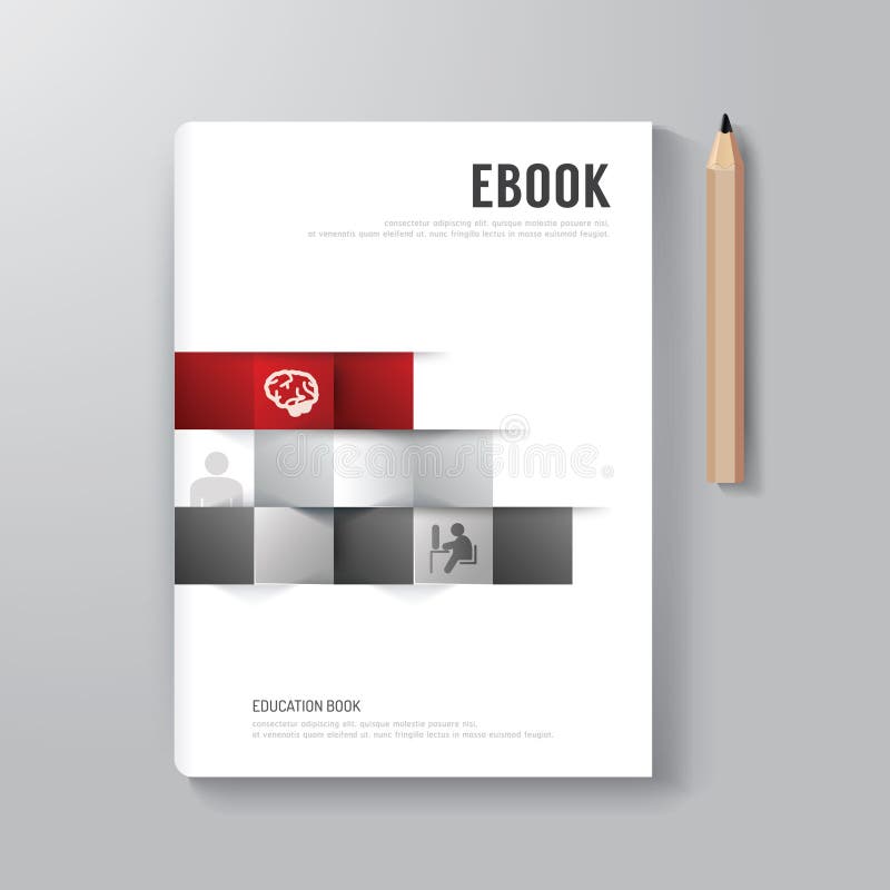
Free with trial Cover Book Digital Design Minimal Style Template / can be used for E-Book Cover/ E-Magazine Cover/ vector illustration. Wiki style vectors Cover Book Digital Design Minimal Style Template. Cover Book Digital Design Minimal Style Template / can be used for E-Book Cover/ E-Magazine Cover/ vector illustration
Free with trial Flat style online education e-learning study knowledge graduation exam infographic concept. Hands on test, tablet online course web site icon banners templates set. Website conceptual flat collection. Wiki style vectors Flat online education e-learning study exam infographic concept. Flat style online education e-learning study knowledge graduation exam infographic concept. Hands on test, tablet online course web site icon banners templates set. Website conceptual flat collection.
Free with trial Flat style odern education infographic concept. Classic library book reading, online wiki search, internet course certification web site icon banners templates set. Template for parallax scroller. Wiki style vectors Flat style web infographic concept. Flat style odern education infographic concept. Classic library book reading, online wiki search, internet course certification web site icon banners templates set. Template for parallax scroller.
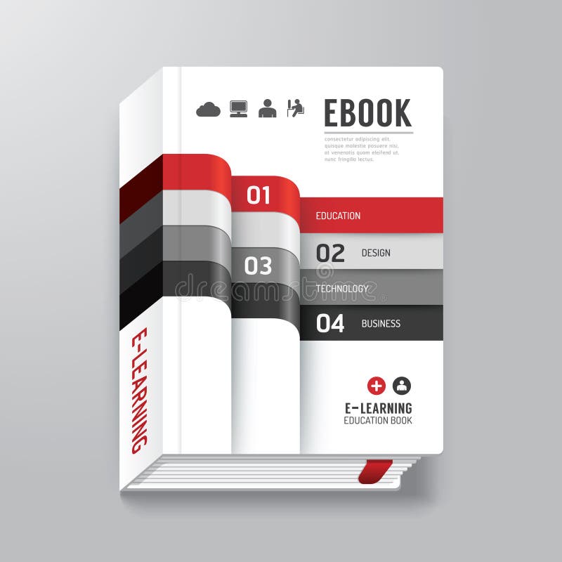
Free with trial Book Cover with Tab Design Style Template / can be used for E-Book Cover/ E-Magazine Cover/ vector illustration. Wiki style vectors Book Cover with Tab Design Style Template . Book Cover with Tab Design Style Template / can be used for E-Book Cover/ E-Magazine Cover/ vector illustration
Free with trial Cover Book Design Minimal Style Template health concept/ can be used for E-Book Cover/ E-Magazine Cover/ vector illustration. Wiki style vectors Cover Book Design Minimal Style Template health concept. Cover Book Design Minimal Style Template health concept/ can be used for E-Book Cover/ E-Magazine Cover/ vector illustration
Free with trial Background concept wordcloud illustration of wiki pages. Wiki style illustrations Wiki pages background concept. Background concept wordcloud illustration of wiki pages
Free with trial Cover Book Digital Design Minimal Style Template / can be used for E-Book Cover/ E-Magazine Cover/ vector illustration. Wiki style vectors Book Cover Digital Design Minimal Style Template. Cover Book Digital Design Minimal Style Template / can be used for E-Book Cover/ E-Magazine Cover/ vector illustration
Free with trial Book Cover Design Style Template / can be used for E-Book Cover/ E-Magazine Cover/ vector illustration. Wiki style vectors Book Cover Design Style Template / can be used for E-Book Cover/ E-Magazine Cover/ vector illustration
Free with trial Cover Book Digital Design Minimal Style Template / can be used for E-Book Cover/ E-Magazine Cover/ vector illustration. Wiki style vectors Book Cover Digital Design Minimal Style Template / can be used f. Cover Book Digital Design Minimal Style Template / can be used for E-Book Cover/ E-Magazine Cover/ vector illustration
Free with trial A vector illustration of various social media keywords. Wiki style vectors Social media keywords
Free with trial Set of modern internet doodles. Wiki style vectors Web 2. 0 doodles. Set of modern internet doodles
Free with trial The frozen art ipa wiki character is depicted in a style reminiscent of characterful animal portraits. the illustration features a white background and showcases an aggressive digital art style. the color palette includes dark white and light beige tones. the character is portrayed with oversized objects, adding a unique touch to the artwork. the image is captured using a topcor 58mm f14 lens,. Wiki style illustrations Cartoon Yeti: A Cute White Giant With Big Eyes And Large Hands. The frozen art ipa wiki character is depicted in a style reminiscent of characterful animal. the frozen art ipa wiki character is depicted in a style reminiscent of characterful animal portraits. the illustration features a white background and showcases an aggressive digital art style. the color palette includes dark white and light beige tones. the character is portrayed with oversized objects, adding a unique touch to the artwork. the image is captured using a topcor 58mm f14 lens,
Free with trial African tectonic plate on the Wiki style elevation map in the Patterson Cylindrical projection centered meridionally. Distribution of known volcanoes. Wiki style illustrations African tectonic plate. Wiki. Patterson Cylindrical. Volcanoes a. African tectonic plate on the Wiki style elevation map in the Patterson Cylindrical projection centered meridionally. Distribution of known volcanoes
Free with trial Eurasian tectonic plate on the Wiki style elevation map in the Loximuthal projection centered meridionally. Boundaries of other plates. Wiki style illustrations Eurasian tectonic plate. Wiki. Loximuthal. Boundaries. Eurasian tectonic plate on the Wiki style elevation map in the Loximuthal projection centered meridionally. Boundaries of other plates
Free with trial Cover Book Digital Design Minimal Style Template. EPS10. Wiki style vectors Cover Book Digital Design Minimal Style Template
Free with trial Bulacan, province of Philippines. Elevation map colored in wiki style with lakes and rivers. Wiki style illustrations Bulacan, Philippines. Wiki. No legend. Bulacan, province of Philippines. Elevation map colored in wiki style with lakes and rivers
Free with trial Zambales, province of Philippines. Elevation map colored in wiki style with lakes and rivers. Wiki style illustrations Zambales, Philippines. Wiki. No legend. Zambales, province of Philippines. Elevation map colored in wiki style with lakes and rivers
Free with trial Syunik, province of Armenia. Elevation map colored in wiki style with lakes and rivers. Wiki style illustrations Syunik, Armenia. Wiki. No legend. Syunik, province of Armenia. Elevation map colored in wiki style with lakes and rivers
Free with trial Biobio, region of Chile. Elevation map colored in wiki style with lakes and rivers. Corner auxiliary location maps. Wiki style illustrations Biobio, Chile. Wiki. Capital. Biobio, region of Chile. Elevation map colored in wiki style with lakes and rivers. Corner auxiliary location maps
Free with trial Tavush, province of Armenia. Elevation map colored in wiki style with lakes and rivers. Corner auxiliary location maps. Wiki style illustrations Tavush, Armenia. Wiki. Capital. Tavush, province of Armenia. Elevation map colored in wiki style with lakes and rivers. Corner auxiliary location maps
Free with trial Andalucia, autonomous community of Spain. Elevation map colored in wiki style with lakes and rivers. Corner auxiliary location maps. Wiki style illustrations Andalucia, Spain. Wiki. Capital. Andalucia, autonomous community of Spain. Elevation map colored in wiki style with lakes and rivers. Corner auxiliary location maps
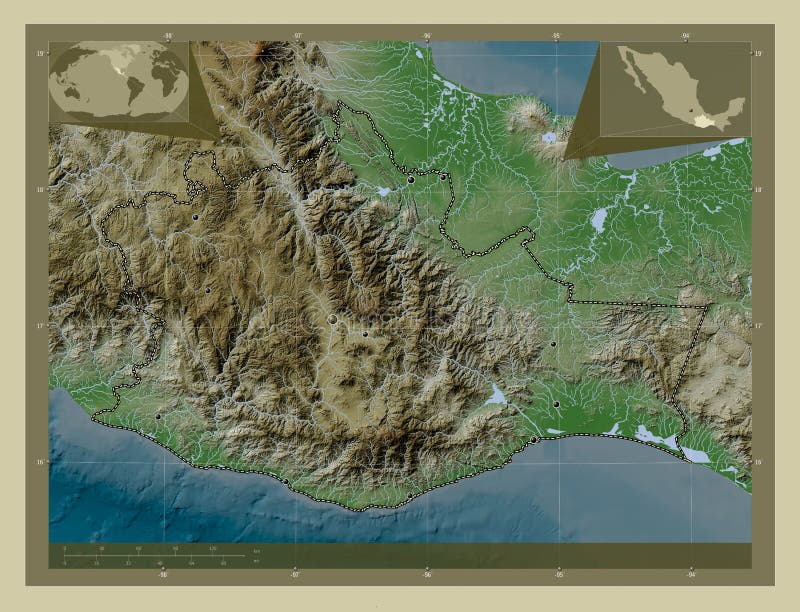
Free with trial Oaxaca, state of Mexico. Elevation map colored in wiki style with lakes and rivers. Locations of major cities of the region. Corner auxiliary location maps. Wiki style illustrations Oaxaca, Mexico. Wiki. Major cities. Oaxaca, state of Mexico. Elevation map colored in wiki style with lakes and rivers. Locations of major cities of the region. Corner auxiliary location maps
Free with trial Cumbria, administrative county of England - Great Britain. Elevation map colored in wiki style with lakes and rivers. Corner auxiliary location maps. Wiki style illustrations Cumbria, England - Great Britain. Wiki. Capital. Cumbria, administrative county of England - Great Britain. Elevation map colored in wiki style with lakes and rivers. Corner auxiliary location maps
Free with trial Canterbury, regional council of New Zealand. Elevation map colored in wiki style with lakes and rivers. Corner auxiliary location maps. Wiki style illustrations Canterbury, New Zealand. Wiki. Capital. Canterbury, regional council of New Zealand. Elevation map colored in wiki style with lakes and rivers. Corner auxiliary location maps
Free with trial Varazdinska, county of Croatia. Elevation map colored in wiki style with lakes and rivers. Locations of major cities of the region. Corner auxiliary location maps. Wiki style illustrations Varazdinska, Croatia. Wiki. Major cities. Varazdinska, county of Croatia. Elevation map colored in wiki style with lakes and rivers. Locations of major cities of the region. Corner auxiliary location maps
Free with trial Ras Al Khaymah, emirate of United Arab Emirates. Elevation map colored in wiki style with lakes and rivers. Corner auxiliary location maps. Wiki style illustrations Ras Al Khaymah, United Arab Emirates. Wiki. Capital. Ras Al Khaymah, emirate of United Arab Emirates. Elevation map colored in wiki style with lakes and rivers. Corner auxiliary location maps
Free with trial Ras Al Khaymah, emirate of United Arab Emirates. Elevation map colored in wiki style with lakes and rivers. Wiki style illustrations Ras Al Khaymah, United Arab Emirates. Wiki. No legend. Ras Al Khaymah, emirate of United Arab Emirates. Elevation map colored in wiki style with lakes and rivers
Free with trial Bihor, county of Romania. Elevation map colored in wiki style with lakes and rivers. Locations and names of major cities of the region. Corner auxiliary location maps. Wiki style illustrations Bihor, Romania. Wiki. Labelled points of cities. Bihor, county of Romania. Elevation map colored in wiki style with lakes and rivers. Locations and names of major cities of the region. Corner auxiliary location maps
Free with trial Ankara, province of Turkiye. Elevation map colored in wiki style with lakes and rivers. Locations and names of major cities of the region. Corner auxiliary location maps. Wiki style illustrations Ankara, Turkiye. Wiki. Labelled points of cities. Ankara, province of Turkiye. Elevation map colored in wiki style with lakes and rivers. Locations and names of major cities of the region. Corner auxiliary location maps
Free with trial Occitanie, region of France. Elevation map colored in wiki style with lakes and rivers. Locations and names of major cities of the region. Corner auxiliary location maps. Wiki style illustrations Occitanie, France. Wiki. Labelled points of cities. Occitanie, region of France. Elevation map colored in wiki style with lakes and rivers. Locations and names of major cities of the region. Corner auxiliary location maps
Free with trial Shape of the Amur tectonic plate on the Wiki style elevation map in the Patterson Cylindrical (oblique) projection. Wiki style illustrations Amur tectonic plate. Wiki map. Shape of the Amur tectonic plate on the Wiki style elevation map in the Patterson Cylindrical (oblique) projection
Free with trial Shape of the African tectonic plate on the Wiki style elevation map in the Patterson Cylindrical (oblique) projection. Wiki style illustrations African tectonic plate. Wiki map. Shape of the African tectonic plate on the Wiki style elevation map in the Patterson Cylindrical (oblique) projection
Free with trial Tectonic plate boundaries adjacent to the Amur tectonic plate on the Wiki style elevation map in the Patterson Cylindrical (oblique) projection. Wiki style illustrations Near Amur plate. Boundaries. Wiki map. Tectonic plate boundaries adjacent to the Amur tectonic plate on the Wiki style elevation map in the Patterson Cylindrical (oblique) projection
Free with trial Tectonic plate boundaries adjacent to the African tectonic plate on the Wiki style elevation map in the Patterson Cylindrical (oblique) projection. Wiki style illustrations Near African plate. Boundaries. Wiki map. Tectonic plate boundaries adjacent to the African tectonic plate on the Wiki style elevation map in the Patterson Cylindrical (oblique) projection
Free with trial Distribution of known volcanoes around the Amur tectonic plate on the Wiki style elevation map in the Patterson Cylindrical (oblique) projection. Wiki style illustrations Volcanoes around the Amur plate. Wiki map. Distribution of known volcanoes around the Amur tectonic plate on the Wiki style elevation map in the Patterson Cylindrical (oblique) projection
Free with trial Distribution of known volcanoes around the African tectonic plate on the Wiki style elevation map in the Patterson Cylindrical (oblique) projection. Wiki style illustrations Volcanoes around the African plate. Wiki map. Distribution of known volcanoes around the African tectonic plate on the Wiki style elevation map in the Patterson Cylindrical (oblique) projection
Free with trial Locations of earthquakes above 6. 5 magnitude recorded since the early 17th century on the world wiki style elevation map in the Times projection centered on the prime meridian. Wiki style illustrations Earthquakes on the world wiki map - 0 PM. Times. Locations of earthquakes above 6.5 magnitude recorded since the early 17th century on the world wiki style elevation map in the Times projection centered on the prime meridian
Free with trial Locations of earthquakes in the vicinity of the African tectonic plate greater than magnitude 6. 5 recorded since the early 17th century on the Wiki style elevation map in the Patterson Cylindrical (oblique) projection. Wiki style illustrations Earthquakes around the African plate. Wiki map. Locations of earthquakes in the vicinity of the African tectonic plate greater than magnitude 6.5 recorded since the early 17th century on the Wiki style elevation map in the Patterson Cylindrical (oblique) projection
Free with trial Amur tectonic plate on the Wiki style elevation map in the Patterson Cylindrical projection centered meridionally. Boundaries of other plates. Wiki style illustrations Amur tectonic plate. Wiki. Patterson Cylindrical. Boundaries. Amur tectonic plate on the Wiki style elevation map in the Patterson Cylindrical projection centered meridionally. Boundaries of other plates
Free with trial Nazca tectonic plate on the Wiki style elevation map in the Patterson Cylindrical projection centered meridionally. Boundaries of other plates. Wiki style illustrations Nazca tectonic plate. Wiki. Patterson Cylindrical. Boundaries. Nazca tectonic plate on the Wiki style elevation map in the Patterson Cylindrical projection centered meridionally. Boundaries of other plates
Free with trial Sunda tectonic plate on the Wiki style elevation map in the Patterson Cylindrical projection centered meridionally. Boundaries of other plates. Wiki style illustrations Sunda tectonic plate. Wiki. Patterson Cylindrical. Boundaries. Sunda tectonic plate on the Wiki style elevation map in the Patterson Cylindrical projection centered meridionally. Boundaries of other plates
Free with trial Tectonic plate boundaries on the world wiki style elevation map in the Times projection centered on the prime meridian. Wiki style illustrations Tectonic plate boundaries on the world wiki map - 0 PM. Times. Tectonic plate boundaries on the world wiki style elevation map in the Times projection centered on the prime meridian
Free with trial Indian tectonic plate on the Wiki style elevation map in the Patterson Cylindrical projection centered meridionally. Boundaries of other plates. Wiki style illustrations Indian tectonic plate. Wiki. Patterson Cylindrical. Boundaries. Indian tectonic plate on the Wiki style elevation map in the Patterson Cylindrical projection centered meridionally. Boundaries of other plates
Free with trial Pacific tectonic plate on the Wiki style elevation map in the Patterson Cylindrical projection centered meridionally. Boundaries of other plates. Wiki style illustrations Pacific tectonic plate. Wiki. Patterson Cylindrical. Boundaries. Pacific tectonic plate on the Wiki style elevation map in the Patterson Cylindrical projection centered meridionally. Boundaries of other plates
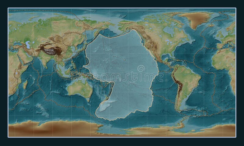
Free with trial African tectonic plate on the Wiki style elevation map in the Patterson Cylindrical projection centered meridionally. Boundaries of other plates. Wiki style illustrations African tectonic plate. Wiki. Patterson Cylindrical. Boundaries. African tectonic plate on the Wiki style elevation map in the Patterson Cylindrical projection centered meridionally. Boundaries of other plates
Free with trial Eurasian tectonic plate on the Wiki style elevation map in the Patterson Cylindrical projection centered meridionally. Distribution of known volcanoes. Wiki style illustrations Eurasian tectonic plate. Wiki. Patterson Cylindrical. Volcanoes. Eurasian tectonic plate on the Wiki style elevation map in the Patterson Cylindrical projection centered meridionally. Distribution of known volcanoes
Free with trial Amur tectonic plate on the Wiki style elevation map in the Patterson Cylindrical projection centered meridionally. Distribution of known volcanoes. Wiki style illustrations Amur tectonic plate. Wiki. Patterson Cylindrical. Volcanoes and. Amur tectonic plate on the Wiki style elevation map in the Patterson Cylindrical projection centered meridionally. Distribution of known volcanoes
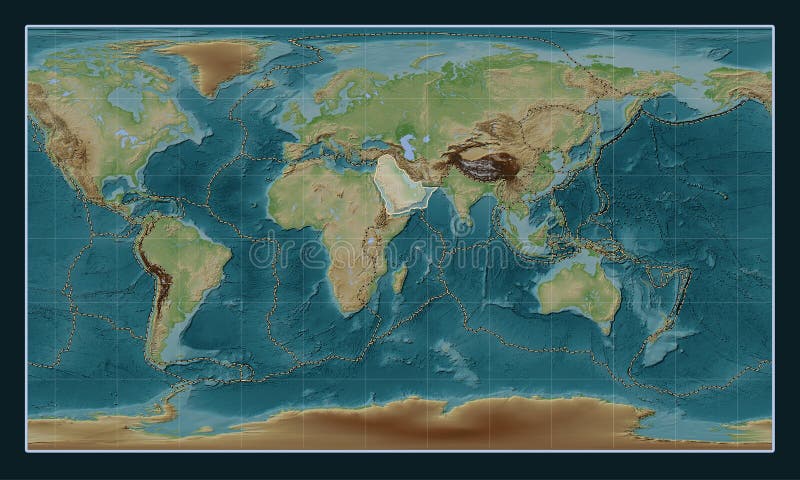
Free with trial Arabian tectonic plate on the Wiki style elevation map in the Patterson Cylindrical projection centered meridionally. Boundaries of other plates. Wiki style illustrations Arabian tectonic plate. Wiki. Patterson Cylindrical. Boundaries. Arabian tectonic plate on the Wiki style elevation map in the Patterson Cylindrical projection centered meridionally. Boundaries of other plates
Free with trial Somalian tectonic plate on the Wiki style elevation map in the Patterson Cylindrical projection centered meridionally. Distribution of known volcanoes. Wiki style illustrations Somalian tectonic plate. Wiki. Patterson Cylindrical. Volcanoes. Somalian tectonic plate on the Wiki style elevation map in the Patterson Cylindrical projection centered meridionally. Distribution of known volcanoes
Free with trial Okhotsk tectonic plate on the Wiki style elevation map in the Patterson Cylindrical projection centered meridionally. Boundaries of other plates. Wiki style illustrations Okhotsk tectonic plate. Wiki. Patterson Cylindrical. Boundaries. Okhotsk tectonic plate on the Wiki style elevation map in the Patterson Cylindrical projection centered meridionally. Boundaries of other plates
Free with trial Indian tectonic plate on the Wiki style elevation map in the Patterson Cylindrical projection centered meridionally. Locations of earthquakes above 6. 5 magnitude recorded since the early 17th century. Wiki style illustrations Indian tectonic plate. Wiki. Patterson Cylindrical. Earthquakes. Indian tectonic plate on the Wiki style elevation map in the Patterson Cylindrical projection centered meridionally. Locations of earthquakes above 6.5 magnitude recorded since the early 17th century
Free with trial Eurasian tectonic plate on the Wiki style elevation map in the Patterson Cylindrical Oblique projection centered meridionally and latitudinally. Locations of earthquakes above 6. 5 magnitude recorded since the early 17th century. Wiki style illustrations Eurasian tectonic plate. Wiki. Patterson Cylindrical Oblique. Ea. Eurasian tectonic plate on the Wiki style elevation map in the Patterson Cylindrical Oblique projection centered meridionally and latitudinally. Locations of earthquakes above 6.5 magnitude recorded since the early 17th century
Free with trial Okhotsk tectonic plate on the Wiki style elevation map in the Patterson Cylindrical Oblique projection centered meridionally and latitudinally. Distribution of known volcanoes. Wiki style illustrations Okhotsk tectonic plate. Wiki. Patterson Cylindrical Oblique. Vol. Okhotsk tectonic plate on the Wiki style elevation map in the Patterson Cylindrical Oblique projection centered meridionally and latitudinally. Distribution of known volcanoes
Free with trial Philippine Sea tectonic plate on the Wiki style elevation map in the Patterson Cylindrical projection centered meridionally. Locations of earthquakes above 6. 5 magnitude recorded since the early 17th century. Wiki style illustrations Philippine Sea tectonic plate. Wiki. Patterson Cylindrical. Eart. Philippine Sea tectonic plate on the Wiki style elevation map in the Patterson Cylindrical projection centered meridionally. Locations of earthquakes above 6.5 magnitude recorded since the early 17th century
Free with trial Somalian tectonic plate on the Wiki style elevation map in the Patterson Cylindrical projection centered meridionally. Locations of earthquakes above 6. 5 magnitude recorded since the early 17th century. Wiki style illustrations Somalian tectonic plate. Wiki. Patterson Cylindrical. Earthquake. Somalian tectonic plate on the Wiki style elevation map in the Patterson Cylindrical projection centered meridionally. Locations of earthquakes above 6.5 magnitude recorded since the early 17th century
Free with trial Amur tectonic plate on the Wiki style elevation map in the Patterson Cylindrical projection centered meridionally. Locations of earthquakes above 6. 5 magnitude recorded since the early 17th century. Wiki style illustrations Amur tectonic plate. Wiki. Patterson Cylindrical. Earthquakes an. Amur tectonic plate on the Wiki style elevation map in the Patterson Cylindrical projection centered meridionally. Locations of earthquakes above 6.5 magnitude recorded since the early 17th century
Free with trial Philippine Sea tectonic plate on the Wiki style elevation map in the Patterson Cylindrical projection centered meridionally. Boundaries of other plates. Wiki style illustrations Philippine Sea tectonic plate. Wiki. Patterson Cylindrical. Boun. Philippine Sea tectonic plate on the Wiki style elevation map in the Patterson Cylindrical projection centered meridionally. Boundaries of other plates
Free with trial Somalian tectonic plate on the Wiki style elevation map in the Patterson Cylindrical projection centered meridionally. Boundaries of other plates. Wiki style illustrations Somalian tectonic plate. Wiki. Patterson Cylindrical. Boundaries. Somalian tectonic plate on the Wiki style elevation map in the Patterson Cylindrical projection centered meridionally. Boundaries of other plates
Free with trial Arabian tectonic plate on the Wiki style elevation map in the Patterson Cylindrical projection centered meridionally. Locations of earthquakes above 6. 5 magnitude recorded since the early 17th century. Wiki style illustrations Arabian tectonic plate. Wiki. Patterson Cylindrical. Earthquakes. Arabian tectonic plate on the Wiki style elevation map in the Patterson Cylindrical projection centered meridionally. Locations of earthquakes above 6.5 magnitude recorded since the early 17th century
Free with trial Pacific tectonic plate on the Wiki style elevation map in the Patterson Cylindrical projection centered meridionally. Distribution of known volcanoes. Wiki style illustrations Pacific tectonic plate. Wiki. Patterson Cylindrical. Volcanoes a. Pacific tectonic plate on the Wiki style elevation map in the Patterson Cylindrical projection centered meridionally. Distribution of known volcanoes
Free with trial Sunda tectonic plate on the Wiki style elevation map in the Patterson Cylindrical Oblique projection centered meridionally and latitudinally. Locations of earthquakes above 6. 5 magnitude recorded since the early 17th century. Wiki style illustrations Sunda tectonic plate. Wiki. Patterson Cylindrical Oblique. Earth. Sunda tectonic plate on the Wiki style elevation map in the Patterson Cylindrical Oblique projection centered meridionally and latitudinally. Locations of earthquakes above 6.5 magnitude recorded since the early 17th century
Free with trial Sunda tectonic plate on the Wiki style elevation map in the Patterson Cylindrical Oblique projection centered meridionally and latitudinally. Boundaries of other plates. Wiki style illustrations Sunda tectonic plate. Wiki. Patterson Cylindrical Oblique. Bound. Sunda tectonic plate on the Wiki style elevation map in the Patterson Cylindrical Oblique projection centered meridionally and latitudinally. Boundaries of other plates
Free with trial Antarctica tectonic plate on the Wiki style elevation map in the Patterson Cylindrical projection centered meridionally. Boundaries of other plates. Wiki style illustrations Antarctica tectonic plate. Wiki. Patterson Cylindrical. Boundari. Antarctica tectonic plate on the Wiki style elevation map in the Patterson Cylindrical projection centered meridionally. Boundaries of other plates
Free with trial Nazca tectonic plate on the Wiki style elevation map in the Patterson Cylindrical Oblique projection centered meridionally and latitudinally. Distribution of known volcanoes. Wiki style illustrations Nazca tectonic plate. Wiki. Patterson Cylindrical Oblique. Volca. Nazca tectonic plate on the Wiki style elevation map in the Patterson Cylindrical Oblique projection centered meridionally and latitudinally. Distribution of known volcanoes
Free with trial Okhotsk tectonic plate on the Wiki style elevation map in the Patterson Cylindrical Oblique projection centered meridionally and latitudinally. Boundaries of other plates. Wiki style illustrations Okhotsk tectonic plate. Wiki. Patterson Cylindrical Oblique. Bou. Okhotsk tectonic plate on the Wiki style elevation map in the Patterson Cylindrical Oblique projection centered meridionally and latitudinally. Boundaries of other plates
Free with trial Indian tectonic plate on the Wiki style elevation map in the Patterson Cylindrical Oblique projection centered meridionally and latitudinally. Boundaries of other plates. Wiki style illustrations Indian tectonic plate. Wiki. Patterson Cylindrical Oblique. Boun. Indian tectonic plate on the Wiki style elevation map in the Patterson Cylindrical Oblique projection centered meridionally and latitudinally. Boundaries of other plates
Free with trial North American tectonic plate on the Wiki style elevation map in the Patterson Cylindrical projection centered meridionally. Distribution of known volcanoes. Wiki style illustrations North American tectonic plate. Wiki. Patterson Cylindrical. Volc. North American tectonic plate on the Wiki style elevation map in the Patterson Cylindrical projection centered meridionally. Distribution of known volcanoes
Free with trial South American tectonic plate on the Wiki style elevation map in the Patterson Cylindrical projection centered meridionally. Locations of earthquakes above 6. 5 magnitude recorded since the early 17th century. Wiki style illustrations South American tectonic plate. Wiki. Patterson Cylindrical. Eart. South American tectonic plate on the Wiki style elevation map in the Patterson Cylindrical projection centered meridionally. Locations of earthquakes above 6.5 magnitude recorded since the early 17th century
Free with trial Australian tectonic plate on the Wiki style elevation map in the Patterson Cylindrical projection centered meridionally. Distribution of known volcanoes. Wiki style illustrations Australian tectonic plate. Wiki. Patterson Cylindrical. Volcanoe. Australian tectonic plate on the Wiki style elevation map in the Patterson Cylindrical projection centered meridionally. Distribution of known volcanoes
Free with trial Somalian tectonic plate on the Wiki style elevation map in the Patterson Cylindrical Oblique projection centered meridionally and latitudinally. Distribution of known volcanoes. Wiki style illustrations Somalian tectonic plate. Wiki. Patterson Cylindrical Oblique. Vo. Somalian tectonic plate on the Wiki style elevation map in the Patterson Cylindrical Oblique projection centered meridionally and latitudinally. Distribution of known volcanoes
Free with trial Arabian tectonic plate on the Wiki style elevation map in the Patterson Cylindrical Oblique projection centered meridionally and latitudinally. Locations of earthquakes above 6. 5 magnitude recorded since the early 17th century. Wiki style illustrations Arabian tectonic plate. Wiki. Patterson Cylindrical Oblique. Ear. Arabian tectonic plate on the Wiki style elevation map in the Patterson Cylindrical Oblique projection centered meridionally and latitudinally. Locations of earthquakes above 6.5 magnitude recorded since the early 17th century
Free with trial Indian tectonic plate on the Wiki style elevation map in the Patterson Cylindrical projection centered meridionally. Distribution of known volcanoes. Wiki style illustrations Indian tectonic plate. Wiki. Patterson Cylindrical. Volcanoes an. Indian tectonic plate on the Wiki style elevation map in the Patterson Cylindrical projection centered meridionally. Distribution of known volcanoes
Free with trial Nazca tectonic plate on the Wiki style elevation map in the Patterson Cylindrical projection centered meridionally. Locations of earthquakes above 6. 5 magnitude recorded since the early 17th century. Wiki style illustrations Nazca tectonic plate. Wiki. Patterson Cylindrical. Earthquakes a. Nazca tectonic plate on the Wiki style elevation map in the Patterson Cylindrical projection centered meridionally. Locations of earthquakes above 6.5 magnitude recorded since the early 17th century
Free with trial Somalian tectonic plate on the Wiki style elevation map in the Patterson Cylindrical Oblique projection centered meridionally and latitudinally. Boundaries of other plates. Wiki style illustrations Somalian tectonic plate. Wiki. Patterson Cylindrical Oblique. Bo. Somalian tectonic plate on the Wiki style elevation map in the Patterson Cylindrical Oblique projection centered meridionally and latitudinally. Boundaries of other plates
Free with trial African tectonic plate on the Wiki style elevation map in the Patterson Cylindrical Oblique projection centered meridionally and latitudinally. Boundaries of other plates. Wiki style illustrations African tectonic plate. Wiki. Patterson Cylindrical Oblique. Bou. African tectonic plate on the Wiki style elevation map in the Patterson Cylindrical Oblique projection centered meridionally and latitudinally. Boundaries of other plates
Free with trial African tectonic plate on the Wiki style elevation map in the Patterson Cylindrical Oblique projection centered meridionally and latitudinally. Distribution of known volcanoes. Wiki style illustrations African tectonic plate. Wiki. Patterson Cylindrical Oblique. Vol. African tectonic plate on the Wiki style elevation map in the Patterson Cylindrical Oblique projection centered meridionally and latitudinally. Distribution of known volcanoes
Free with trial Antarctica tectonic plate on the Wiki style elevation map in the Patterson Cylindrical projection centered meridionally. Locations of earthquakes above 6. 5 magnitude recorded since the early 17th century. Wiki style illustrations Antarctica tectonic plate. Wiki. Patterson Cylindrical. Earthqua. Antarctica tectonic plate on the Wiki style elevation map in the Patterson Cylindrical projection centered meridionally. Locations of earthquakes above 6.5 magnitude recorded since the early 17th century
Free with trial Indian tectonic plate on the Wiki style elevation map in the Patterson Cylindrical Oblique projection centered meridionally and latitudinally. Locations of earthquakes above 6. 5 magnitude recorded since the early 17th century. Wiki style illustrations Indian tectonic plate. Wiki. Patterson Cylindrical Oblique. Eart. Indian tectonic plate on the Wiki style elevation map in the Patterson Cylindrical Oblique projection centered meridionally and latitudinally. Locations of earthquakes above 6.5 magnitude recorded since the early 17th century
Free with trial Okhotsk tectonic plate on the Wiki style elevation map in the Patterson Cylindrical projection centered meridionally. Locations of earthquakes above 6. 5 magnitude recorded since the early 17th century. Wiki style illustrations Okhotsk tectonic plate. Wiki. Patterson Cylindrical. Earthquakes. Okhotsk tectonic plate on the Wiki style elevation map in the Patterson Cylindrical projection centered meridionally. Locations of earthquakes above 6.5 magnitude recorded since the early 17th century