Free with trial 3D grass map of 25 United States including: Montana MT Nebraska NE Nevada NV New Hampshire NH New Jersey NJ New Mexico NM New York NY North Carolina NC North Dakota ND Ohio OH Oklahoma OK Oregon OR Pennsylvania PA Rhode Island RI South Carolina SC South Dakota SD Tennessee TN Texas TX Utah UT Vermont VT Virginia VA Washington WA West Virginia WV Wisconsin WI Wyoming WY. Zip code map illustrations US State Maps Set II. 3D grass map of 25 United States including: Montana MT Nebraska NE Nevada NV New Hampshire NH New Jersey NJ New Mexico NM New York NY North Carolina NC North Dakota ND Ohio OH Oklahoma OK Oregon OR Pennsylvania PA Rhode Island RI South Carolina SC South Dakota SD Tennessee TN Texas TX Utah UT Vermont VT Virginia VA Washington WA West Virginia WV Wisconsin WI Wyoming WY
Free with trial 2-digit postcode areas Switzerland map. Zip code map vectors 2-digit postcode areas Switzerland
Free with trial 3D grass map of 25 United States including: Alabama AL Alaska AK Arizona AZ Arkansas AR California CA Colorado CO Connecticut CT Delaware DE Florida FL Georgia GA Hawaii HI Idaho ID Illinois IL Indiana IN Iowa IA Kansas KS Kentucky KY Louisiana LA Maine ME Maryland MD Massachusetts MA Michigan MI Minnesota MN Mississippi MS Missouri MO. Zip code map illustrations US State Maps Set I. 3D grass map of 25 United States including: Alabama AL Alaska AK Arizona AZ Arkansas AR California CA Colorado CO Connecticut CT Delaware DE Florida FL Georgia GA Hawaii HI Idaho ID Illinois IL Indiana IN Iowa IA Kansas KS Kentucky KY Louisiana LA Maine ME Maryland MD Massachusetts MA Michigan MI Minnesota MN Mississippi MS Missouri MO
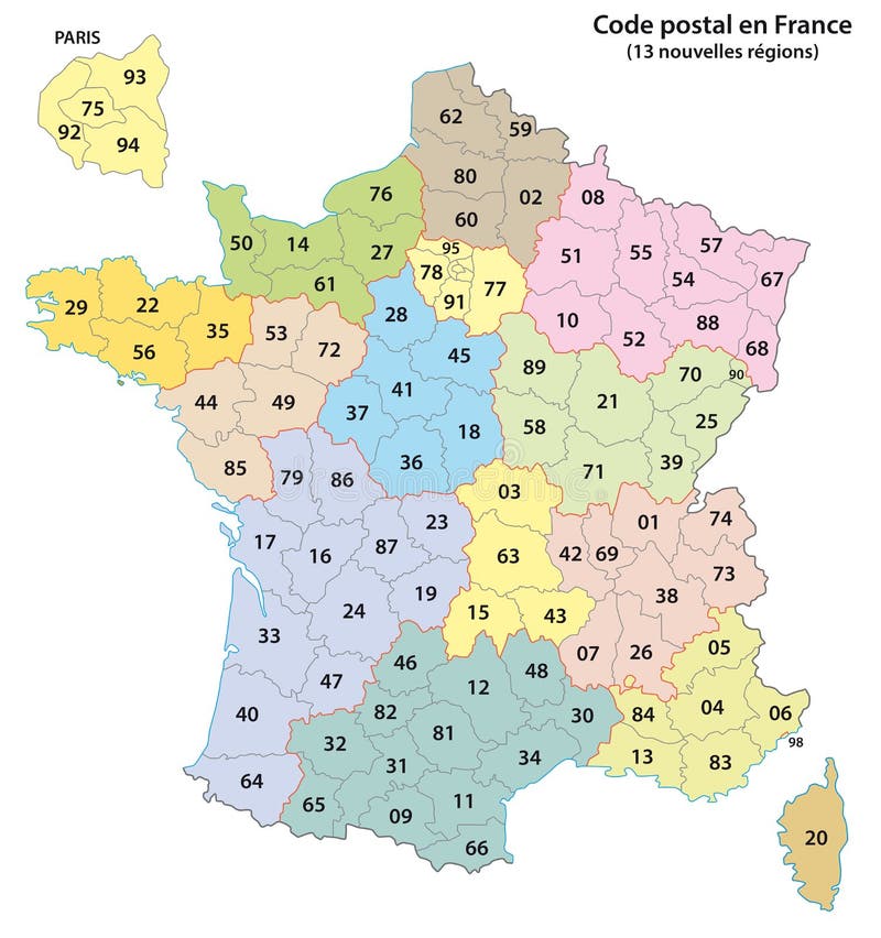
Free with trial France 2-digit postcodes map 2017 13 Regions. Zip code map vectors France 2-digit postcodes map 2017
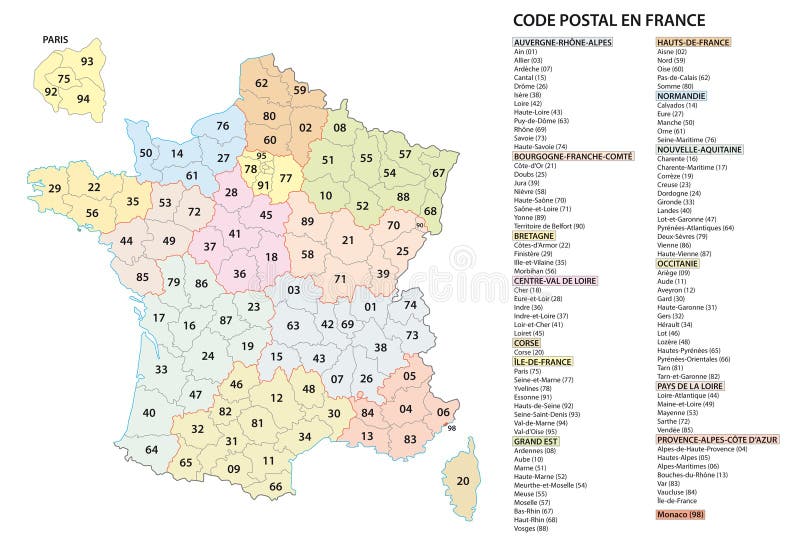
Free with trial France 2 digit postcodes postal codes vector map. Zip code map vectors France 2 digit postcodes postal codes vector map
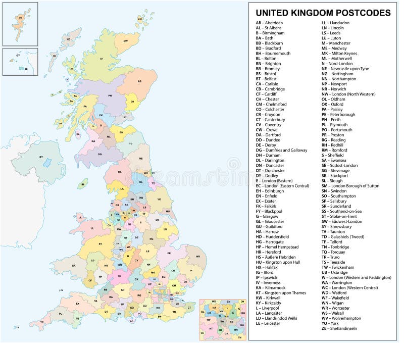
Free with trial United kingdom Postcodes or postal codes vector map. Zip code map vectors United kingdom Postcodes or postal codes vector map
Free with trial A spain province map with 2-digit zip codes. Zip code map vectors A spain province map with 2-digit zip codes
Free with trial Filled delivery and logistic icon set. contain flat supply chain, delivery safety, air mail, logistic protection, zip code, delivery cart, worldwide, scooter, shipping, earth grid icons in editable. Zip code map vectors Filled delivery and logistic icon set. contain flat supply chain, delivery safety, air mail, logistic protection, zip code
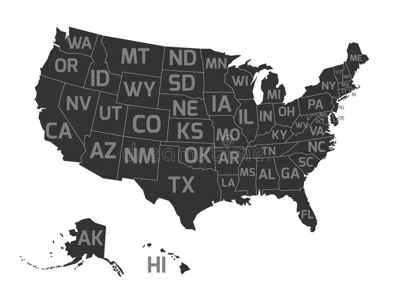
Free with trial Map of United States od America, aka USA, with US states abbreviation zip codes. Flat simplified dark grey vector map with light grey labels on white background. Zip code map vectors Map of USA with state abbreviations. Map of United States od America, aka USA, with US states abbreviation zip codes. Flat simplified dark grey vector map with light grey labels on white background.
Free with trial United kingdom Postcodes or postal codes vector map. Zip code map vectors United kingdom Postcodes or postal codes vector map
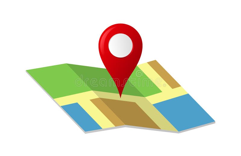
Free with trial Concept Clipart design of illustrator vector a Map with a pin Location address company isolated on white / transparent background. Zip code map vectors Map with a Red Pin Icon. Concept Clipart design of illustrator vector a Map with a pin Location address company isolated on white / transparent background.
Free with trial Los Angeles outline map California city shape vector illustration. Zip code map vectors Los Angeles outline map California city shape
Free with trial Delve into the fascinating history of the United States postal service with this vintage-inspired zip code map. This detailed chart showcases the geographic distribution of postal codes across the nation, providing a unique perspective on the evolution of mail delivery systems. The retro aesthetic adds a touch of vintage charm, perfect for those with a passion for cartography and the postal. Zip code map illustrations US Zip Code Map A RetroStyle Geographic Chart for Postal History Buffs and Geography Enthusiasts. Delve into the fascinating history of the United States postal service with this vintage-inspired zip code map. This detailed chart showcases the geographic distribution of postal codes across the nation, providing a unique perspective on the evolution of mail delivery systems. The retro aesthetic adds a touch of vintage charm, perfect for those with a passion for cartography and the postal
Free with trial This detailed map of Spain's provinces provides a comprehensive geographic overview, essential for businesses and residents alike. The map clearly displays each province, its boundaries, and crucial postal codes represented by 2-digit zip codes. This allows for accurate address referencing and facilitates quick identification of specific regions. Navigating through diverse landscapes, from the. Zip code map illustrations Comprehensive Spain Province Map with 2Digit Zip Codes A Detailed Geographic Overview for Businesses and Residents. This detailed map of Spain's provinces provides a comprehensive geographic overview, essential for businesses and residents alike. The map clearly displays each province, its boundaries, and crucial postal codes represented by 2-digit zip codes. This allows for accurate address referencing and facilitates quick identification of specific regions. Navigating through diverse landscapes, from the
Free with trial Find us on brown paper. Background. Zip code map illustrations Find us on brown paper. Background
Free with trial An illustration of a post office mark icon. Zip code map vectors Illustration of post office mark icon. An illustration of a post office mark icon.
Free with trial Dive into the world of advanced tech and engineering solutions transforming industries and enhancing everyday life. Zip code map illustrations Explore the cuttingedge innovations in technology and engineering for a smarter, more efficient future. Dive into the world of advanced tech and engineering solutions transforming industries and enhancing everyday life
Free with trial Dive into the world of advanced tech and engineering solutions transforming industries and enhancing everyday life. Zip code map illustrations Explore the cuttingedge innovations in technology and engineering for a smarter, more efficient future. Dive into the world of advanced tech and engineering solutions transforming industries and enhancing everyday life.
Free with trial Dive into a modern visual of technology and data visualization, featuring waves and textures that illustrate quantum concepts. Zip code map illustrations Explore a vibrant abstract background of tech connections with lines and dots, showcasing the flow of digital data. Dive into a modern visual of technology and data visualization, featuring waves and textures that illustrate quantum concepts
Free with trial Elevate your real estate website and marketing materials with stunning stock photos that inspire and engage Discover a curated collection of dream homes, from cozy cottages to luxurious mansions, capturing the essence of each property Find the perfect image to showcase your listings and captivate potential buyers AI Generative. Zip code map illustrations Discover Your Dream Home Browse Stunning Properties Find Your Perfect Abode Stock Photos for Real Estate Websites and Marketing. Elevate your real estate website and marketing materials with stunning stock photos that inspire and engage Discover a curated collection of dream homes, from cozy cottages to luxurious mansions, capturing the essence of each property Find the perfect image to showcase your listings and captivate potential buyers AI Generative
Free with trial An illustration of a gray post office mark icon. Zip code map vectors Illustration of a gray post office mark icon
Free with trial Dive into the world of advanced tech and engineering solutions transforming industries and enhancing everyday life. Zip code map illustrations Explore the cuttingedge innovations in technology and engineering for a smarter, more efficient future. Dive into the world of advanced tech and engineering solutions transforming industries and enhancing everyday life.