Free with trial Aisle view of an Asda supermarket on August 18, 2014 in London, UK. Founded in 1949 Asda is the UK's third largest retail chain with 568 stores and an operating income of £638 million. 638 stock images, royalty-free photos and pictures Supermarket Aisle View. Aisle view of an Asda supermarket on August 18, 2014 in London, UK. Founded in 1949 Asda is the UK's third largest retail chain with 568 stores and an operating income of £638 million.
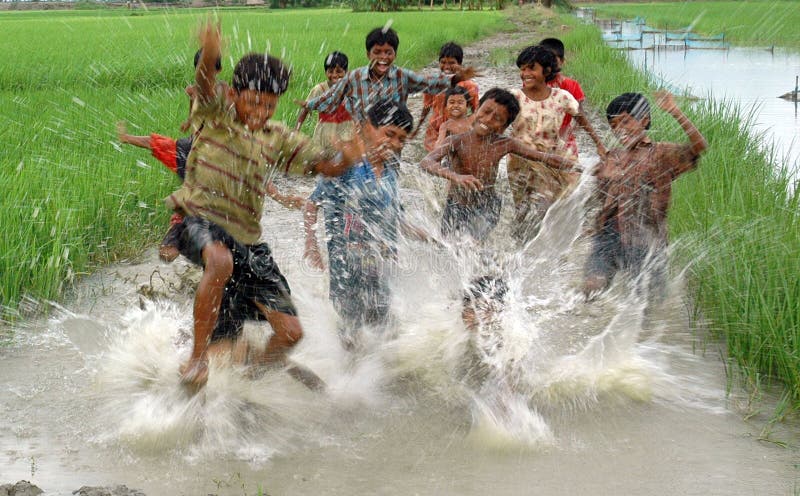
Free with trial Children are playing with water. he Sundarban island has no paved roads, no electricity, no public sanitation and no motorized transport as yet. There is a small part-time post office about 14 miles away in main market. With a majority of its over 1 billion citizens still living in small villages, rural life remains central to India’s identity. According to the 2001 Indian census, 74% of Indians still live in 638,365 different villages. 638 stock images, royalty-free photos and pictures Child's play. Children are playing with water. he Sundarban island has no paved roads, no electricity, no public sanitation and no motorized transport as yet. There is a small part-time post office about 14 miles away in main market. With a majority of its over 1 billion citizens still living in small villages, rural life remains central to India’s identity. According to the 2001 Indian census, 74% of Indians still live in 638,365 different villages.
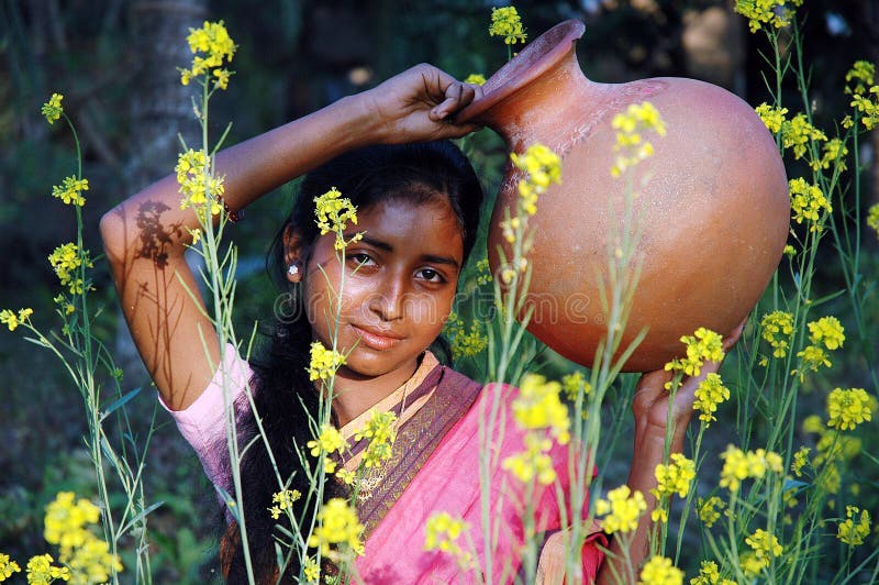
Free with trial The Sundarban island has no paved roads, no electricity, no public sanitation and no motorized transport as yet. There is a small part-time post office about 14 miles away in main market. With a majority of its over 1 billion citizens still living in small villages, rural life remains central to India’s identity. According to the 2001 Indian census, 74% of Indians still live in 638,365 different villages. 638 stock images, royalty-free photos and pictures A village girl. The Sundarban island has no paved roads, no electricity, no public sanitation and no motorized transport as yet. There is a small part-time post office about 14 miles away in main market. With a majority of its over 1 billion citizens still living in small villages, rural life remains central to India’s identity. According to the 2001 Indian census, 74% of Indians still live in 638,365 different villages.
Free with trial Village women going to collect water. The Sundarban island has no paved roads, no electricity, no public sanitation and no motorized transport as yet. There is a small part-time post office about 14 miles away in main market. With a majority of its over 1 billion citizens still living in small villages, rural life remains central to India’s identity. According to the 2001 Indian census, 74% of Indians still live in 638, 365 different villages. 638 stock images, royalty-free photos and pictures Village women. Village women going to collect water. The Sundarban island has no paved roads, no electricity, no public sanitation and no motorized transport as yet. There is a small part-time post office about 14 miles away in main market. With a majority of its over 1 billion citizens still living in small villages, rural life remains central to India’s identity. According to the 2001 Indian census, 74% of Indians still live in 638, 365 different villages.
Free with trial London, UK - August 18, 2014: A shopper browses an aisle at an Asda supermarket. Walmart owned Asda is the UK`s 2nd largest retail chain after Tesco with 568 stores and an income of £638 mln in 2013. 638 stock images, royalty-free photos and pictures Shopper Browses Supermarket Aisle. London, UK - August 18, 2014: A shopper browses an aisle at an Asda supermarket. Walmart owned Asda is the UK`s 2nd largest retail chain after Tesco with 568 stores and an income of £638 mln in 2013.
Free with trial Orlando, Florida. November 27, 2019. Panoramic view of Chinese Theater at Hollywood Studios 638. 638 stock images, royalty-free photos and pictures Panoramic view of Chinese Theater at Hollywood Studios 638
Free with trial Orlando, Florida. November 27, 2019. Partial view of Chinese Theater at Hollywood Studios 638. 638 stock images, royalty-free photos and pictures Partial view of Chinese Theater at Hollywood Studios 638
Free with trial Childeric Deposes 511-638, Popular History of France by Henri Martin, Furne Publisher 1860. 638 stock images, royalty-free photos and pictures Editor Furne 1860. Childeric Deposes 511-638, Popular History of France by Henri Martin, Furne Publisher 1860
Free with trial King Eudes fleeing Bordeaux in Flames511-638, popular history of frrance by Henri Martin, Furne Publisher 1860. 638 stock images, royalty-free photos and pictures Editor Furne 1860. King Eudes fleeing Bordeaux in Flames511-638, popular history of frrance by Henri Martin, Furne Publisher 1860
Free with trial HOLLYWOOD, FLORIDA, USA: Guitar shaped hotel built by the Seminole Indian Tribe. With 638 guest rooms & large pool lounging area, an unusual original design for a hotel as seen on November 20, 2019. 638 stock images, royalty-free photos and pictures Beautiful Hard Rock Guitar Hotel. HOLLYWOOD, FLORIDA, USA: Guitar shaped hotel built by the Seminole Indian Tribe. With 638 guest rooms & large pool lounging area, an unusual original design for a hotel as seen on November 20, 2019
Free with trial Children are playing with water. he Sundarban island has no paved roads, no electricity, no public sanitation and no motorized transport as yet. There is a small part-time post office about 14 miles away in main market. With a majority of its over 1 billion citizens still living in small villages, rural life remains central to India’s identity. According to the 2001 Indian census, 74% of Indians still live in 638,365 different villages. 638 stock images, royalty-free photos and pictures Child's play. Children are playing with water. he Sundarban island has no paved roads, no electricity, no public sanitation and no motorized transport as yet. There is a small part-time post office about 14 miles away in main market. With a majority of its over 1 billion citizens still living in small villages, rural life remains central to India’s identity. According to the 2001 Indian census, 74% of Indians still live in 638,365 different villages.
Free with trial With a majority of its over 1 billion citizens still living in small villages, rural life remains central to India’s identity. According to the 2001 Indian census, 74% of Indians still live in 638,365 different villages. 638 stock images, royalty-free photos and pictures Rural India. With a majority of its over 1 billion citizens still living in small villages, rural life remains central to India’s identity. According to the 2001 Indian census, 74% of Indians still live in 638,365 different villages.
Free with trial With a majority of its over 1 billion citizens still living in small villages, rural life remains central to India’s identity. According to the 2001 Indian census, 74% of Indians still live in 638,365 different villages. 638 stock images, royalty-free photos and pictures Rural Lifestyle. With a majority of its over 1 billion citizens still living in small villages, rural life remains central to India’s identity. According to the 2001 Indian census, 74% of Indians still live in 638,365 different villages.
Free with trial With a majority of its over 1 billion citizens still living in small villages, rural life remains central to India’s identity. According to the 2001 Indian census, 74% of Indians still live in 638,365 different villages. 638 stock images, royalty-free photos and pictures Rural Lifestyle. With a majority of its over 1 billion citizens still living in small villages, rural life remains central to India’s identity. According to the 2001 Indian census, 74% of Indians still live in 638,365 different villages.
Free with trial With a majority of its over 1 billion citizens still living in small villages, rural life remains central to India’s identity. According to the 2001 Indian census, 74% of Indians still live in 638,365 different villages. 638 stock images, royalty-free photos and pictures Indian Village Life. With a majority of its over 1 billion citizens still living in small villages, rural life remains central to India’s identity. According to the 2001 Indian census, 74% of Indians still live in 638,365 different villages.
Free with trial Group of children posing at a Indian village. According to the statistics by Census of India, 2001, 72. 20% lives in rural India, which comprises of 638,596 traditional villages, with no sanitation facility, schools, and other facilities. 638 stock images, royalty-free photos and pictures Indian children at a village. Group of children posing at a Indian village . According to the statistics by Census of India, 2001, 72.20% lives in rural India, which comprises of 638,596 traditional villages, with no sanitation facility, schools, and other facilities
Free with trial Woman presenting Customer Relationship Journey. 638 stock images, royalty-free photos and pictures Customer Relationship Journey
Free with trial Beautiful and young blond girl isolated. 638 stock images, royalty-free photos and pictures Blond Girl 638. Beautiful and young blond girl isolated
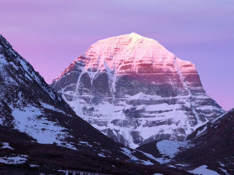
Free with trial Sunrise on Mount Kailash Scenic view, Mount Kailash, is a 6,638 m high peak in the Kailash Range, which forms part of the Transhimalaya in the Ngari Prefecture, Tibet Autonomous Region, China. 638 stock images, royalty-free photos and pictures Sunrise on Mount Kailash Scenic view
Free with trial Man presenting Customer Relationship Journey. 638 stock images, royalty-free photos and pictures Customer Relationship Journey
Free with trial Almora district is a district in the Kumaon division of Uttarakhand state, India. The headquarters is at Almora. It is 1,638 meters above sea level. The town of Almora is surrounded by Pithoragarh district to the east, Garhwal region to the west, Bageshwar district to the north and Nainital district to the south. The hill station of Almora is situated on a horseshoe-shaped ridge of a mountain. 638 stock images, royalty-free photos and pictures A scenic view from Almora, Kumaun, India. Almora district is a district in the Kumaon division of Uttarakhand state, India. The headquarters is at Almora. It is 1,638 meters above sea level. The town of Almora is surrounded by Pithoragarh district to the east, Garhwal region to the west, Bageshwar district to the north and Nainital district to the south. The hill station of Almora is situated on a horseshoe-shaped ridge of a mountain
Free with trial The Temple of Olympian Zeus also known as the Olympieion or Columns of the Olympian Zeus, is a colossal ruined temple in the centre of the Greek capital Athens that was dedicated to Zeus, king of the Olympian gods. Construction began in the 6th century BC during the rule of the Athenian tyrants, who envisaged building the greatest temple in the ancient world, but it was not completed until the reign of the Roman Emperor Hadrian in the 2nd century AD some 638 years after the project had begun. During the Roman periods it was renowned as the largest temple in Greece and housed one of the largest cult statues in the ancient world. 638 stock images, royalty-free photos and pictures Atens. The Temple of Olympian Zeus. The Temple of Olympian Zeus also known as the Olympieion or Columns of the Olympian Zeus, is a colossal ruined temple in the centre of the Greek capital Athens that was dedicated to Zeus, king of the Olympian gods. Construction began in the 6th century BC during the rule of the Athenian tyrants, who envisaged building the greatest temple in the ancient world, but it was not completed until the reign of the Roman Emperor Hadrian in the 2nd century AD some 638 years after the project had begun. During the Roman periods it was renowned as the largest temple in Greece and housed one of the largest cult statues in the ancient world.
Free with trial A. P. Giannini founded his Bank of Italy on this site in 1904, in a former saloon. When the earthquake and fire of 1906 hit, Giannini took all of the banks assets, including $80,000 in gold, the equivalent of $2,638,293. 33 today, hidden under cart of fruits and vegitables of a horse drawn cart, and took it to his home down in San Mateo for safe keeping. And safe it was, the bank burned down to the ground. And, since his money was now safe, he was able to keep loaning out to his customers, which kept their faith in his bank. Many other banks in the area did not fair so well, as their assets were either lost, or stuck in badly damaged buildings. This new building, the Columbo Building, opened in 1913. 638 stock images, royalty-free photos and pictures Columbo Building original Bank of Italy San Francisco 4. A.P. Giannini founded his Bank of Italy on this site in 1904, in a former saloon. When the earthquake and fire of 1906 hit, Giannini took all of the banks assets, including $80,000 in gold, the equivalent of $2,638,293.33 today, hidden under cart of fruits and vegitables of a horse drawn cart, and took it to his home down in San Mateo for safe keeping. And safe it was, the bank burned down to the ground. And, since his money was now safe, he was able to keep loaning out to his customers, which kept their faith in his bank. Many other banks in the area did not fair so well, as their assets were either lost, or stuck in badly damaged buildings. This new building, the Columbo Building, opened in 1913.
Free with trial In electrical grids, they are generally used to carry high-voltage transmission lines that transport bulk electric power from generating stations to electrical substations; utility poles are used to support lower-voltage subtransmission and distribution lines that transport power from substations to electric customers. They come in a wide variety of shapes and sizes. Typical height ranges from 15 to 55 m 49 to 180 ft,[1] though the tallest are the 380 m 1,247 ft towers of a 2,656 m 8,714 ft span between the islands Jintang and Cezi. The longest span of any hydroelectric crossing ever built belongs to the powerline crossing of Ameralik fjord with a length of 5,376 m 17,638 ft. In addition to steel, other materials may be used, including concrete and wood. 638 stock images, royalty-free photos and pictures A power tower with its electriciy cables, under the blue sky. In electrical grids, they are generally used to carry high-voltage transmission lines that transport bulk electric power from generating stations to electrical substations; utility poles are used to support lower-voltage subtransmission and distribution lines that transport power from substations to electric customers. They come in a wide variety of shapes and sizes. Typical height ranges from 15 to 55 m 49 to 180 ft,[1] though the tallest are the 380 m 1,247 ft towers of a 2,656 m 8,714 ft span between the islands Jintang and Cezi. The longest span of any hydroelectric crossing ever built belongs to the powerline crossing of Ameralik fjord with a length of 5,376 m 17,638 ft. In addition to steel, other materials may be used, including concrete and wood.
Free with trial London, UK - August 18, 2014: An aisle is seen in an Asda supermarket. Walmart owned Asda is the UK`s second largest retail chain after Tesco with around 570 stores and an income of £638 mln in 2013. 638 stock images, royalty-free photos and pictures Supermarket Aisle View. London, UK - August 18, 2014: An aisle is seen in an Asda supermarket. Walmart owned Asda is the UK`s second largest retail chain after Tesco with around 570 stores and an income of £638 mln in 2013.
Free with trial Editorial photo of the last preseason baseball game between the Philadelphia Phillies and the Pitsburg Pirates at Brighthouse field in Clearwater, Florida on April 1, 2010. 638 stock images, royalty-free photos and pictures Phillies, Pirates preseason 638. Editorial photo of the last preseason baseball game between the Philadelphia Phillies and the Pitsburg Pirates at Brighthouse field in Clearwater, Florida on April 1, 2010
Free with trial A landscape image of the Chehalis River Bridge built in 1955 with a total span of 2,638. 3 ft. 638 stock images, royalty-free photos and pictures Aberdeen, Washington / USA - March 10, 2018: Warren deck truss bascule bridge over Chehalis River on US 101 in Aberdeen. A landscape image of the Chehalis River Bridge built in 1955 with a total span of 2,638.3 ft.
Free with trial Red motorcycle Jawa 638 parked on the road. Trees or bushes in the background. The road goes into the distance. Autumn colors - yellow, green, red, blue. Old, rare, collectible motorcycles. 638 stock images, royalty-free photos and pictures Red motorcycle Jawa 638 parked on the road. Trees or bushes in the background. The road goes into the distance. Autumn colors -
Free with trial Red motorcycle Jawa 638 parked on the road. Trees or bushes in the background. The road goes into the distance. Autumn colors - yellow, green, red, blue. Old, rare, collectible motorcycles. 638 stock images, royalty-free photos and pictures Red motorcycle Jawa 638 parked on the road. Trees or bushes in the background. The road goes into the distance. Autumn colors -
Free with trial Red motorcycle Jawa 638 parked on the road. Trees or bushes in the background. The road goes into the distance. Autumn colors - yellow, green, red, blue. Old, rare, collectible motorcycles. 638 stock images, royalty-free photos and pictures Red motorcycle Jawa 638 parked on the road. Trees or bushes in the background. The road goes into the distance. Autumn colors -
Free with trial Red motorcycle Jawa 638 parked on the road. Trees or bushes in the background. The road goes into the distance. Autumn colors - yellow, green, red, blue. Old, rare, collectible motorcycles. 638 stock images, royalty-free photos and pictures Red motorcycle Jawa 638 parked on the road. Trees or bushes in the background. The road goes into the distance. Autumn colors -
Free with trial Birthday Cupcakes With Candles Lit Forming The Number 638 - Photo On Blue Background. 638 stock images, royalty-free photos and pictures Birthday Cupcakes With Candles Lit Forming The Number 638
Free with trial 638 4 strange old lt striking a tall building, creating a dramatic and awe-inspiring moment, photo. Изображение 4 из 4. 638 stock images, royalty-free photos and pictures 638 47. Lightning bolt striking a tall building, creat. 638 4 strange old lt striking a tall building, creating a dramatic and awe-inspiring moment, photo. Изображение 4 из 4
Free with trial 638 1 rare odd olt hitting the ground in a fiery display, creating a dramatic and intense scene, photo. Изображение 4 из 4. 638 stock images, royalty-free photos and pictures 638 105. Lightning bolt hitting the ground in a fiery. 638 1 rare odd olt hitting the ground in a fiery display, creating a dramatic and intense scene, photo. Изображение 4 из 4
Free with trial Historic 'Steam Engine 638' on display in Trinidad, Colorado. 638 stock images, royalty-free photos and pictures Historic \'Steam Engine 638\' on display in Trinidad. Historic 'Steam Engine 638' on display in Trinidad, Colorado
Free with trial Mount Kailash, is a 6,638 m high peak in the Kailash Range, which forms part of the Transhimalaya in the Tibet Autonomous Region of China. 638 stock images, royalty-free photos and pictures Mount Kailash, is a 6,638 m high peak in the Kailash Range in Tibet. Mount Kailash, is a 6,638 m high peak in the Kailash Range, which forms part of the Transhimalaya in the Tibet Autonomous Region of China
Free with trial Birthday Cake With Candles Number 638 - Photo On Pink Background. 638 stock images, royalty-free photos and pictures Birthday Cake With Candles Number 638
Free with trial Murder of the children of Clodomir 511-638, Popular History of France by Henri Martin, Publisher Furne 1860. 638 stock images, royalty-free photos and pictures Editor Furne 1860. Murder of the children of Clodomir 511-638, Popular History of France by Henri Martin, Publisher Furne 1860
Free with trial Torture of Brunehaut 511-638 Popular history of France by Henri Martin, editor Furne 1860. 638 stock images, royalty-free photos and pictures Editor Furne 1860
Free with trial SIGEBERT ELEVE On shield 511-638, popular history of France by Henri Martin, FURNE EDITOR 1860. 638 stock images, royalty-free photos and pictures Editor Furne 1860. SIGEBERT ELEVE On shield 511-638, popular history of France by Henri Martin, FURNE EDITOR 1860
Free with trial Between De Chilperic and Galsuinte in Rouen511-638, popular story of Frrance by Henri Martin, Furne Publisher 1860. 638 stock images, royalty-free photos and pictures Editor Furne 1860. Between De Chilperic and Galsuinte in Rouen511-638, popular story of Frrance by Henri Martin, Furne Publisher 1860
Free with trial Charle Martel and Abderame at the Battle of Poitiers 511-638, popular history of frrance by Henri Martin, editor Furne 1860. 638 stock images, royalty-free photos and pictures Editor Furne 1860
Free with trial Lazy king on his beef chariot 511-638 popular history of frrance by Henri Martin, editor Furne 1860. 638 stock images, royalty-free photos and pictures Editor Furne 1860
Free with trial Fredegonde and its sicaries 511-638, Popular History of France by Henri Martin, editor Furne 1860. 638 stock images, royalty-free photos and pictures Editor Furne 1860
Free with trial Birthday Or Anniversary Cupcake With Lit Candles Candles Forming The Number 638 - Photo on a blue background. 638 stock images, royalty-free photos and pictures Birthday Or Anniversary Cupcake With Lit Candles Candles Forming The Number 638
Free with trial Mount Kailash, is a 6,638 m high peak in the Kailash Range, which forms part of the Transhimalaya in the Tibet Autonomous Region of China. 638 stock images, royalty-free photos and pictures Mount Kailash, is a 6,638 m high peak in the Kailash Range in Tibet. Mount Kailash, is a 6,638 m high peak in the Kailash Range, which forms part of the Transhimalaya in the Tibet Autonomous Region of China
Free with trial Mount Kailash, is a 6,638 m high peak in the Kailash Range, which forms part of the Transhimalaya in the Tibet Autonomous Region of China. 638 stock images, royalty-free photos and pictures Mount Kailash, is a 6,638 m high peak in the Kailash Range in Tibet. Mount Kailash, is a 6,638 m high peak in the Kailash Range, which forms part of the Transhimalaya in the Tibet Autonomous Region of China
Free with trial The archaeological site of Castro Ventosa is located in the village of Pieros (Municipality of Cacabelos) sharing territory with Villafranca del Bierzo, on a hill formed by the river C�a at 638 meters altitude, and from which you can see almost the entire region. 638 stock images, royalty-free photos and pictures Detail of the rural landscape of El Bierzo from Castro Ventosa. The archaeological site of Castro Ventosa is located in the village of Pieros (Municipality of Cacabelos) sharing territory with Villafranca del Bierzo, on a hill formed by the river C�a at 638 meters altitude, and from which you can see almost the entire region.
Free with trial The archaeological site of Castro Ventosa is located in the village of Pieros (Municipality of Cacabelos) sharing territory with Villafranca del Bierzo, on a hill formed by the river C�a at 638 meters altitude, and from which you can see almost the entire region. 638 stock images, royalty-free photos and pictures Detail of the rural landscape of El Bierzo from Castro Ventosa. The archaeological site of Castro Ventosa is located in the village of Pieros (Municipality of Cacabelos) sharing territory with Villafranca del Bierzo, on a hill formed by the river C�a at 638 meters altitude, and from which you can see almost the entire region.
Free with trial The archaeological site of Castro Ventosa is located in the village of Pieros (Municipality of Cacabelos) sharing territory with Villafranca del Bierzo, on a hill formed by the river C�a at 638 meters altitude, and from which you can see almost the entire region. 638 stock images, royalty-free photos and pictures Detail of the rural landscape of El Bierzo from Castro Ventosa. The archaeological site of Castro Ventosa is located in the village of Pieros (Municipality of Cacabelos) sharing territory with Villafranca del Bierzo, on a hill formed by the river C�a at 638 meters altitude, and from which you can see almost the entire region.
Free with trial The archaeological site of Castro Ventosa is located in the village of Pieros (Municipality of Cacabelos) sharing territory with Villafranca del Bierzo, on a hill formed by the river C�a at 638 meters altitude, and from which you can see almost the entire region. 638 stock images, royalty-free photos and pictures Detail of the rural landscape of El Bierzo from Castro Ventosa. The archaeological site of Castro Ventosa is located in the village of Pieros (Municipality of Cacabelos) sharing territory with Villafranca del Bierzo, on a hill formed by the river C�a at 638 meters altitude, and from which you can see almost the entire region.
Free with trial The archaeological site of Castro Ventosa is located in the village of Pieros (Municipality of Cacabelos) sharing territory with Villafranca del Bierzo, on a hill formed by the river C�a at 638 meters altitude, and from which you can see almost the entire region. 638 stock images, royalty-free photos and pictures Detail of the rural landscape of El Bierzo from Castro Ventosa. The archaeological site of Castro Ventosa is located in the village of Pieros (Municipality of Cacabelos) sharing territory with Villafranca del Bierzo, on a hill formed by the river C�a at 638 meters altitude, and from which you can see almost the entire region.
Free with trial The archaeological site of Castro Ventosa is located in the village of Pieros (Municipality of Cacabelos) sharing territory with Villafranca del Bierzo, on a hill formed by the river C�a at 638 meters altitude, and from which you can see almost the entire region. 638 stock images, royalty-free photos and pictures Detail of the rural landscape of El Bierzo from Castro Ventosa. The archaeological site of Castro Ventosa is located in the village of Pieros (Municipality of Cacabelos) sharing territory with Villafranca del Bierzo, on a hill formed by the river C�a at 638 meters altitude, and from which you can see almost the entire region.
Free with trial The archaeological site of Castro Ventosa is located in the village of Pieros (Municipality of Cacabelos) sharing territory with Villafranca del Bierzo, on a hill formed by the river C�a at 638 meters altitude, and from which you can see almost the entire region. 638 stock images, royalty-free photos and pictures Detail of the rural landscape of El Bierzo from Castro Ventosa. The archaeological site of Castro Ventosa is located in the village of Pieros (Municipality of Cacabelos) sharing territory with Villafranca del Bierzo, on a hill formed by the river C�a at 638 meters altitude, and from which you can see almost the entire region.
Free with trial The archaeological site of Castro Ventosa is located in the village of Pieros (Municipality of Cacabelos) sharing territory with Villafranca del Bierzo, on a hill formed by the river C�a at 638 meters altitude, and from which you can see almost the entire region. 638 stock images, royalty-free photos and pictures Detail of the rural landscape of El Bierzo from Castro Ventosa. The archaeological site of Castro Ventosa is located in the village of Pieros (Municipality of Cacabelos) sharing territory with Villafranca del Bierzo, on a hill formed by the river C�a at 638 meters altitude, and from which you can see almost the entire region.
Free with trial The archaeological site of Castro Ventosa is located in the village of Pieros (Municipality of Cacabelos) sharing territory with Villafranca del Bierzo, on a hill formed by the river C�a at 638 meters altitude, and from which you can see almost the entire region. 638 stock images, royalty-free photos and pictures Detail of the rural landscape of El Bierzo from Castro Ventosa. The archaeological site of Castro Ventosa is located in the village of Pieros (Municipality of Cacabelos) sharing territory with Villafranca del Bierzo, on a hill formed by the river C�a at 638 meters altitude, and from which you can see almost the entire region.
Free with trial The archaeological site of Castro Ventosa is located in the village of Pieros (Municipality of Cacabelos) sharing territory with Villafranca del Bierzo, on a hill formed by the river C�a at 638 meters altitude, and from which you can see almost the entire region. 638 stock images, royalty-free photos and pictures Detail of the rural landscape of El Bierzo from Castro Ventosa. The archaeological site of Castro Ventosa is located in the village of Pieros (Municipality of Cacabelos) sharing territory with Villafranca del Bierzo, on a hill formed by the river C�a at 638 meters altitude, and from which you can see almost the entire region.
Free with trial The archaeological site of Castro Ventosa is located in the village of Pieros (Municipality of Cacabelos) sharing territory with Villafranca del Bierzo, on a hill formed by the river C�a at 638 meters altitude, and from which you can see almost the entire region. 638 stock images, royalty-free photos and pictures Detail of the rural landscape of El Bierzo from Castro Ventosa. The archaeological site of Castro Ventosa is located in the village of Pieros (Municipality of Cacabelos) sharing territory with Villafranca del Bierzo, on a hill formed by the river C�a at 638 meters altitude, and from which you can see almost the entire region.
Free with trial Tamesis, Antioquia - Colombia. July 22, 2025. Aerial view from a drone, located 1,638 meters above sea level. 638 stock images, royalty-free photos and pictures Tamesis, Antioquia - Colombia. July 22, 2025. A municipality surrounded by mountains, with 16,706 inhabitants. Tamesis, Antioquia - Colombia. July 22, 2025. Aerial view from a drone, located 1,638 meters above sea level
Free with trial ISTANBUL, TURKIYE - JULY 11, 2024: Turkish Airlines Airbus A350-941 (638) landing to Istanbul International Airport. 638 stock images, royalty-free photos and pictures Airplane Landing to Istanbul Airport. ISTANBUL, TURKIYE - JULY 11, 2024: Turkish Airlines Airbus A350-941 (638) landing to Istanbul International Airport
Free with trial Badajoz, Spain - June 14th, 2018: 638 kilometer of Spanish National N-630 Road. Urban sing post. 638 stock images, royalty-free photos and pictures Spanish National N-630 Road, Badajoz, Spain. Badajoz, Spain - June 14th, 2018: 638 kilometer of Spanish National N-630 Road. Urban sing post
Free with trial Badajoz, Spain - June 14th, 2018: 638 kilometer of Spanish National N-630 Road. Urban sing post. 638 stock images, royalty-free photos and pictures Spanish National N-630 Road, Badajoz, Spain. Badajoz, Spain - June 14th, 2018: 638 kilometer of Spanish National N-630 Road. Urban sing post
Free with trial Tamesis, Antioquia - Colombia. July 22, 2025. It is a mountainous municipality located in the western Andes mountain range. 638 stock images, royalty-free photos and pictures Tamesis, Antioquia - Colombia. July 22, 2025. Aerial view from a drone, located 1,638 meters above sea level. Tamesis, Antioquia - Colombia. July 22, 2025. It is a mountainous municipality located in the western Andes mountain range
Free with trial Mount Namuna, located in Purang County, Ali Region, Xizang Autonomous Region, China, is the highest peak in the western section of the Himalayas, with an elevation of 7,694 meters. ? This mountain stands in stark contrast to the main peak of the Gangdise Mountains, Kangchenjunga, which reaches an elevation of 6,638 meters, forming a magnificent geographical and cultural landscape in western Xizang. ? Mapam Yumco is a freshwater lake, so herdsmen in Xizang drive their cattle and sheep to graze by the lake. However, this place is located at an altitude of over 4,500 meters, and only a very small number of people live here. . ?. 638 stock images, royalty-free photos and pictures Mabengyong Lake and Namuna Snow Mountain in Xizang. Mount Namuna, located in Purang County, Ali Region, Xizang Autonomous Region, China, is the highest peak in the western section of the Himalayas, with an elevation of 7,694 meters. ?This mountain stands in stark contrast to the main peak of the Gangdise Mountains, Kangchenjunga, which reaches an elevation of 6,638 meters, forming a magnificent geographical and cultural landscape in western Xizang. ?Mapam Yumco is a freshwater lake, so herdsmen in Xizang drive their cattle and sheep to graze by the lake. However, this place is located at an altitude of over 4,500 meters, and only a very small number of people live here.
Free with trial Mount Namuna, located in Purang County, Ali Region, Xizang Autonomous Region, China, is the highest peak in the western section of the Himalayas, with an elevation of 7,694 meters. ? This mountain stands in stark contrast to the main peak of the Gangdise Mountains, Kangchenjunga, which reaches an elevation of 6,638 meters, forming a magnificent geographical and cultural landscape in western Xizang. ? Mapam Yumco is a freshwater lake, so herdsmen in Xizang drive their cattle and sheep to graze by the lake. However, this place is located at an altitude of over 4,500 meters, and only a very small number of people live here. . ?. 638 stock images, royalty-free photos and pictures Mabengyong Lake and Namuna Snow Mountain in Xizang. Mount Namuna, located in Purang County, Ali Region, Xizang Autonomous Region, China, is the highest peak in the western section of the Himalayas, with an elevation of 7,694 meters. ?This mountain stands in stark contrast to the main peak of the Gangdise Mountains, Kangchenjunga, which reaches an elevation of 6,638 meters, forming a magnificent geographical and cultural landscape in western Xizang. ?Mapam Yumco is a freshwater lake, so herdsmen in Xizang drive their cattle and sheep to graze by the lake. However, this place is located at an altitude of over 4,500 meters, and only a very small number of people live here.
Free with trial Mount Namuna, located in Purang County, Ali Region, Xizang Autonomous Region, China, is the highest peak in the western section of the Himalayas, with an elevation of 7,694 meters. ? This mountain stands in stark contrast to the main peak of the Gangdise Mountains, Kangchenjunga, which reaches an elevation of 6,638 meters, forming a magnificent geographical and cultural landscape in western Xizang. ? Mapam Yumco is a freshwater lake, so herdsmen in Xizang drive their cattle and sheep to graze by the lake. However, this place is located at an altitude of over 4,500 meters, and only a very small number of people live here. AI??????????. . ?. 638 stock images, royalty-free photos and pictures Mabengyong Lake and Namuna Snow Mountain in Xizang. Mount Namuna, located in Purang County, Ali Region, Xizang Autonomous Region, China, is the highest peak in the western section of the Himalayas, with an elevation of 7,694 meters. ?This mountain stands in stark contrast to the main peak of the Gangdise Mountains, Kangchenjunga, which reaches an elevation of 6,638 meters, forming a magnificent geographical and cultural landscape in western Xizang. ?Mapam Yumco is a freshwater lake, so herdsmen in Xizang drive their cattle and sheep to graze by the lake. However, this place is located at an altitude of over 4,500 meters, and only a very small number of people live here.AI??????????
Free with trial Mount Namuna, located in Purang County, Ali Region, Xizang Autonomous Region, China, is the highest peak in the western section of the Himalayas, with an elevation of 7,694 meters. ? This mountain stands in stark contrast to the main peak of the Gangdise Mountains, Kangchenjunga, which reaches an elevation of 6,638 meters, forming a magnificent geographical and cultural landscape in western Xizang. ? Mapam Yumco is a freshwater lake, so herdsmen in Xizang drive their cattle and sheep to graze by the lake. However, this place is located at an altitude of over 4,500 meters, and only a very small number of people live here. . ?. 638 stock images, royalty-free photos and pictures Mabengyong Lake and Namuna Snow Mountain in Xizang. Mount Namuna, located in Purang County, Ali Region, Xizang Autonomous Region, China, is the highest peak in the western section of the Himalayas, with an elevation of 7,694 meters. ?This mountain stands in stark contrast to the main peak of the Gangdise Mountains, Kangchenjunga, which reaches an elevation of 6,638 meters, forming a magnificent geographical and cultural landscape in western Xizang. ?Mapam Yumco is a freshwater lake, so herdsmen in Xizang drive their cattle and sheep to graze by the lake. However, this place is located at an altitude of over 4,500 meters, and only a very small number of people live here.
Free with trial Mount Namuna, located in Purang County, Ali Region, Xizang Autonomous Region, China, is the highest peak in the western section of the Himalayas, with an elevation of 7,694 meters. ? This mountain stands in stark contrast to the main peak of the Gangdise Mountains, Mount Kangchenjunga, which reaches an elevation of 6,638 meters, forming a magnificent geographical and cultural landscape in western Xizang. ? Standing by the edge of Mapam Yumco Lake, one can gaze upon the distant Namuna Nini Mountains. . ?. 638 stock images, royalty-free photos and pictures Mabengyong Lake and Namuna Snow Mountain in Xizang. Mount Namuna, located in Purang County, Ali Region, Xizang Autonomous Region, China, is the highest peak in. Mount Namuna, located in Purang County, Ali Region, Xizang Autonomous Region, China, is the highest peak in the western section of the Himalayas, with an elevation of 7,694 meters. ?This mountain stands in stark contrast to the main peak of the Gangdise Mountains, Mount Kangchenjunga, which reaches an elevation of 6,638 meters, forming a magnificent geographical and cultural landscape in western Xizang. ?Standing by the edge of Mapam Yumco Lake, one can gaze upon the distant Namuna Nini Mountains.
Free with trial A sign for Amazon's Unit 638 at Northwest Logistics Park is prominently displayed along a road. The sign has a blue background with the Amazon logo and the unit number in white. The logistics park logo is at the top. In the background, there is a warehouse with modern architecture, and some road barriers and street lights are visible. The setting appears to be an industrial or commercial area, typically associated with distribution and logistics operations. 638 stock images, royalty-free photos and pictures Amazon
Free with trial ISTANBUL, TURKIYE - JULY 12, 2025: Turkish Airlines Airbus A350-941 (638) landing to Istanbul International Airport. 638 stock images, royalty-free photos and pictures Airplane landing to Istanbul Airport. ISTANBUL, TURKIYE - JULY 12, 2025: Turkish Airlines Airbus A350-941 (638) landing to Istanbul International Airport
Free with trial A. P. Giannini founded his Bank of Italy on this site in 1904, in a former saloon. When the earthquake and fire of 1906 hit, Giannini took all of the banks assets, including $80,000 in gold, the equivalent of $2,638,293. 33 today, hidden under carts of fruits and vegitables of a horse drawn cart, and took it to his home down in San Mateo for safe keeping. And safe it was, the bank burned down to the ground. And, since his money was now safe, he was able to keep loaning out to his customers, which kept their faith in his bank. Many other banks in the area did not fair so well, as their assets were either lost, or stuck in badly damaged buildings. This new building, the Columbo Building, opened in 1913. 638 stock images, royalty-free photos and pictures Columbo Building original Bank of Italy Jackson Square San Francisco 1. A.P. Giannini founded his Bank of Italy on this site in 1904, in a former saloon. When the earthquake and fire of 1906 hit, Giannini took all of the banks assets, including $80,000 in gold, the equivalent of $2,638,293.33 today, hidden under carts of fruits and vegitables of a horse drawn cart, and took it to his home down in San Mateo for safe keeping. And safe it was, the bank burned down to the ground. And, since his money was now safe, he was able to keep loaning out to his customers, which kept their faith in his bank. Many other banks in the area did not fair so well, as their assets were either lost, or stuck in badly damaged buildings.This new building, the Columbo Building, opened in 1913.
Free with trial Cloudy blue sky for abstract nature backgrounds. 638 stock images, royalty-free photos and pictures Nature background 638. Cloudy blue sky for abstract nature backgrounds.
Free with trial Broken brick wall for abstract backgrounds and textures. 638 stock images, royalty-free photos and pictures Abstract background 638. Broken brick wall for abstract backgrounds and textures.
Free with trial Lazy king on his beef chariot 511-638 popular history of frrance by Henri Martin, editor Furne 1860. 638 stock images, royalty-free photos and pictures Henri Martin, editor Furne 1860
Free with trial What started out as a celebration of the San Francisco gay community celebrating the first anniversary of Stonewall Riots of the New York City Gay community after their police raided the gay Stonewall Bar, has spread around the country and the rest of the world, where the Gay and Lesbian communities are allowed to express themselves. Although it was sparked by the events of New York City, San Francisco has what is considered the largest Gay Pride Parade nationally. The parade route goes from the San Francisco Embarcadero to Civic Center Plaza, about one and half miles, has about 50 Thousand participants, with an additional quarter million spectators, for this very joyous and peaceful event on 29 June 2025. 638 stock images, royalty-free photos and pictures 55th Annual Gay Pride Parade 2025 San Francisco 638. What started out as a celebration of the San Francisco gay community celebrating the first anniversary of Stonewall Riots of the New York City Gay community after their police raided the gay Stonewall Bar, has spread around the country and the rest of the world, where the Gay and Lesbian communities are allowed to express themselves. Although it was sparked by the events of New York City, San Francisco has what is considered the largest Gay Pride Parade nationally. The parade route goes from the San Francisco Embarcadero to Civic Center Plaza, about one and half miles, has about 50 Thousand participants, with an additional quarter million spectators, for this very joyous and peaceful event on 29 June 2025.
Free with trial Fredegonde and its sicaries 511-638, Popular History of France by Henri Martin, editor Furne 1860. 638 stock images, royalty-free photos and pictures Henri Martin, editor Furne 1860
Free with trial The plan of the abbey of Saint Denis presents in Dagobert511-638, popular history of Frrance by Henri Martin, editor Furne 1860. 638 stock images, royalty-free photos and pictures Henri Martin, editor Furne 1860
Free with trial Childeric Deposes 511-638, Popular History of France by Henri Martin, Furne Publisher 1860. 638 stock images, royalty-free photos and pictures Henri Martin, editor Furne 1860. Childeric Deposes 511-638, Popular History of France by Henri Martin, Furne Publisher 1860
Free with trial San Francisco Annual Carnaval celebration has been compared to the New Orleans Mardi Gras celebration, which it is very similar to. They are both Latin celebrations with a lot of eating and drinking, sometimes all to excess, the last week before the Catholic holiday of Lent, after which there are restrictions on both. The main difference between the two is, where as the New Orleans Mardi Gras celebration has a very French flavor because of New Orleans history, San Francisco having such a large and diverse Latin and Caribbean mix, her Carnival is both much larger and more diverse. Having been in different parts of The City, and different dates, it is now in the heart of the Latin section of the The Mission District, and now at the end of May, for more favorable weather. San Francisco Annual Carnival always starts with the festival on day one, and the Grand Parade on day two. The Parade starts with the Lowriders being escorted by the San Francisco Police Motorcycle Brigade, showing the harmony between the police and the various communities of the city. The highlight of the whole event are the many teams of dancers. This years theme is about the African Diaspora throughout the Caribbean and Latin regions, with an estimated nearly five hundred thousand people coming out and enjoying the event 25 May 2025. 638 stock images, royalty-free photos and pictures San Francisco Annual Carnaval 2025 day two The Parade Dancers 638. San Francisco Annual Carnaval celebration has been compared to the New Orleans Mardi Gras celebration, which it is very similar to. They are both Latin celebrations with a lot of eating and drinking, sometimes all to excess, the last week before the Catholic holiday of Lent, after which there are restrictions on both. The main difference between the two is, where as the New Orleans Mardi Gras celebration has a very French flavor because of New Orleans history, San Francisco having such a large and diverse Latin and Caribbean mix, her Carnival is both much larger and more diverse. Having been in different parts of The City, and different dates, it is now in the heart of the Latin section of the The Mission District, and now at the end of May, for more favorable weather. San Francisco Annual Carnival always starts with the festival on day one, and the Grand Parade on day two. The Parade starts with the Lowriders being escorted by the San Francisco Police Motorcycle Brigade, showing the harmony between the police and the various communities of the city. The highlight of the whole event are the many teams of dancers. This years theme is about the African Diaspora throughout the Caribbean and Latin regions, with an estimated nearly five hundred thousand people coming out and enjoying the event 25 May 2025.
Free with trial ISTANBUL, TURKIYE - JULY 12, 2025: Turkish Airlines Airbus A350-941 (638) landing to Istanbul International Airport. 638 stock images, royalty-free photos and pictures Airplane landing to Istanbul Airport. ISTANBUL, TURKIYE - JULY 12, 2025: Turkish Airlines Airbus A350-941 (638) landing to Istanbul International Airport


![In electrical grids, they are generally used to carry high-voltage transmission lines that transport bulk electric power from generating stations to electrical substations; utility poles are used to support lower-voltage subtransmission and distribution lines that transport power from substations to electric customers. They come in a wide variety of shapes and sizes. Typical height ranges from 15 to 55 m 49 to 180 ft,[1] though the tallest are the 380 m 1,247 ft towers of a 2,656 m 8,714 ft span between the islands Jintang and Cezi. The longest span of any hydroelectric crossing ever built belongs to the powerline crossing of Ameralik fjord with a length of 5,376 m 17,638 ft. In addition to steel, other materials may be used, including concrete and wood. 638 stock images, royalty-free photos and pictures](https://thumbs.dreamstime.com/b/power-tower-its-electriciy-cables-under-blue-sky-electrical-grids-generally-used-to-carry-high-voltage-213599008.jpg)