Free with trial Christ of Vung Tau is a statue of Jesus, located on Mount Nho in Vung Tau, Ba Ria-Vung Tau Province, Nam Bo, Vietnam. It was built in 1974 & completed in 1993. Nho stock images, royalty-free photos and pictures Jesus Statue - Vietnam, Vung Tau. Christ of Vung Tau is a statue of Jesus, located on Mount Nho in Vung Tau, Ba Ria-Vung Tau Province, Nam Bo, Vietnam. It was built in 1974 & completed in 1993.
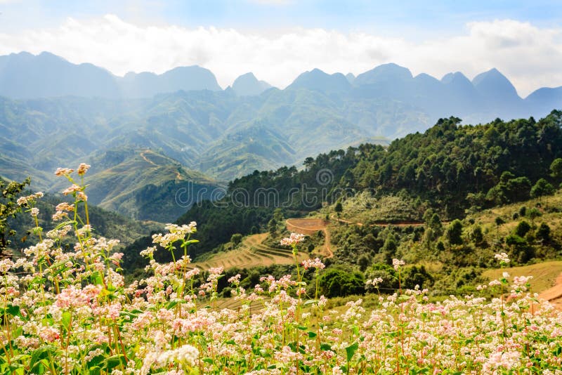
Free with trial Tam Giac Mach is the name of flowers that always apear in autumn at Van Ha Giang North Vietnam. Nho stock images, royalty-free photos and pictures Tam Giac Mach Flowers Farm. Tam Giac Mach is the name of flowers that always apear in autumn at Van Ha Giang North Vietnam
Free with trial Christ of Vung Tau is a statue of Jesus, located on Mount Nho in Vung Tau, Ba Ria-Vung Tau Province, Nam Bo, Vietnam. It was built in 1974 & completed in 1993. Nho stock images, royalty-free photos and pictures Jesus Statue - Vietnam, Vung Tau. Christ of Vung Tau is a statue of Jesus, located on Mount Nho in Vung Tau, Ba Ria-Vung Tau Province, Nam Bo, Vietnam. It was built in 1974 & completed in 1993.
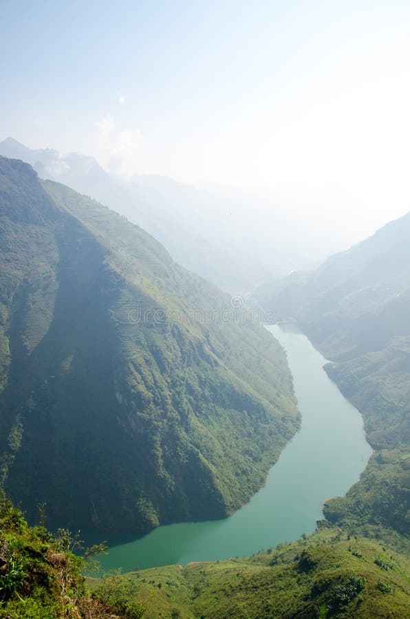
Free with trial Beautiful landscape scene of Nho Que River in Ha Giang - Vietnam. Nho stock images, royalty-free photos and pictures Nho Que River in Ha Giang - Vietnam
Free with trial Nho Que River in Ha Giang, Vietnam. Nho stock images, royalty-free photos and pictures Nho Que River in Ha Giang
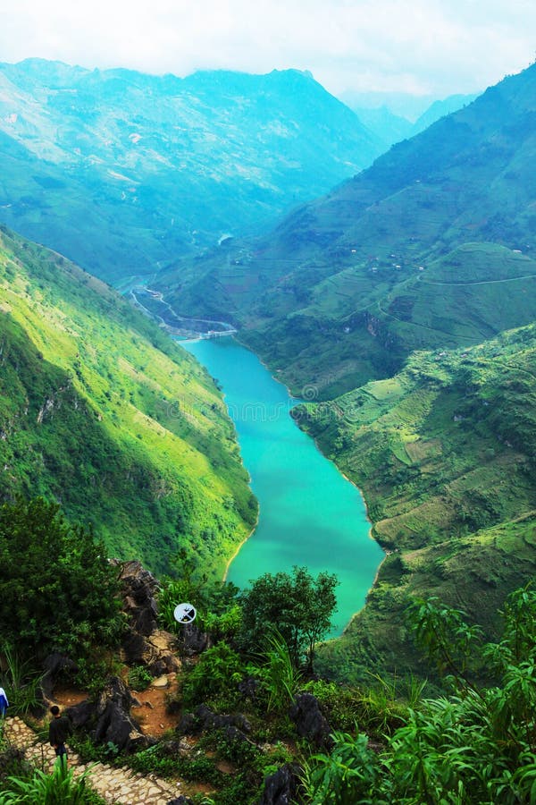
Free with trial Nho Que River Valley panorama, this river splits 24km winding mountain long as rooted in China flows through Vietnam, which also the symbol Ha Giang Province, Vietnam. Nho stock images, royalty-free photos and pictures Nho Que River Valley
Free with trial Nho Que river valley on rocky plateau followed hills covered with green grass and cloud cover make nature more majestic than. Nho stock images, royalty-free photos and pictures Nho Que river valley on rocky plateau
Free with trial Travel in Asia, Nho Que river, Ha Giang, Vietnam. Nho stock images, royalty-free photos and pictures Nho Que river, Ha Giang, Vietnam
Free with trial Beautiful morning light at the water dams hydroelectric power station of Nho Que river surrounded by mountains during foggy from the Ma Pi Leng pass, Dong Van Geopark, Ha Giang, Northern Vietnam. Nho stock images, royalty-free photos and pictures Beautiful morning light at water dams hydroelectric power station of Nho Que river surrounded by mountains during foggy from the. Beautiful morning light at the water dams hydroelectric power station of Nho Que river surrounded by mountains during foggy from the Ma Pi Leng pass, Dong Van Geopark, Ha Giang, Northern Vietnam
Free with trial Nho Que river, at Ha Giang, mountain field in north Vietnam. Ha Giang is one of the six poorest provinces of Vietnam. Ha Giang is a famous tourist destination in Vietnam. Photo taken on: 03 May 2011. Nho stock images, royalty-free photos and pictures Nho Que river, at Ha Giang, mountain field in north Vietnam.
Free with trial Ha Giang, Vietnam - October 20th, 2018: Stunning view of the Nho Que river surrounded by mountains from the Ma Pi Leng pass in northern Vietnam. Nho stock images, royalty-free photos and pictures Ha Giang, Vietnam - October 20th, 2018: Stunning view of the Nho Que river surrounded by mountains from the Ma Pi Leng pass
Free with trial Nho Que river, at Ha Giang, mountain field in north Vietnam. Ha Giang is one of the six poorest provinces of Vietnam. Ha Giang is a famous tourist destination in Vietnam. Photo taken on: 03 May 2011. Nho stock images, royalty-free photos and pictures Nho Que river, at Ha Giang, mountain field in north Vietnam.
Free with trial Ha Giang, Vietnam - March 18, 2018: Stunning view of the Nho Que river surrounded by mountains from the Ma Pi Leng pass in northern Vietnam. Nho stock images, royalty-free photos and pictures Nho Que river Ma Pi Leng pass Vietnam. Ha Giang, Vietnam - March 18, 2018: Stunning view of the Nho Que river surrounded by mountains from the Ma Pi Leng pass in northern Vietnam
Free with trial Nho Que river, at Ha Giang, mountain field in north Vietnam. Ha Giang is one of the six poorest provinces of Vietnam. Ha Giang is a famous tourist destination in Vietnam. Photo taken on: 03 May 2011. Nho stock images, royalty-free photos and pictures Nho Que river, at Ha Giang, mountain field in north Vietnam.
Free with trial Nho Que river, at Ha Giang, mountain field in north Vietnam. Ha Giang is one of the six poorest provinces of Vietnam. Ha Giang is a famous tourist destination in Vietnam. Photo taken on: 03 May 2011. Nho stock images, royalty-free photos and pictures Nho Que river, at Ha Giang, mountain field in north Vietnam.
Free with trial Ha Giang, Vietnam - October 20th, 2018: Stunning view of the Nho Que river surrounded by mountains from the Ma Pi Leng pass in northern Vietnam. Nho stock images, royalty-free photos and pictures Ha Giang, Vietnam - October 20th, 2018: Stunning view of the Nho Que river surrounded by mountains from the Ma Pi Leng pass
Free with trial Ha Giang, Vietnam - March 18, 2018: Stunning view of the Nho Que river surrounded by mountains from the Ma Pi Leng pass in northern Vietnam. Nho stock images, royalty-free photos and pictures Nho Que river Ma Pi Leng pass Vietnam. Ha Giang, Vietnam - March 18, 2018: Stunning view of the Nho Que river surrounded by mountains from the Ma Pi Leng pass in northern Vietnam
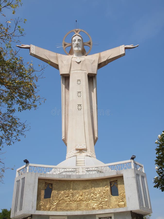
Free with trial Christ the King, of Vung Tau is a statue of Jesus, standing on Mount Nho in Vũng Tàu, Bà Rịa–Vũng Tàu Province, Đông Nam Bộ, Vietnam. The Vietnam Catholic Association built the statue in 1974 and it was completed in 1993. It is 32 metres high, standing on a 4 metres high platform, for a 36 metres 118 ft total monument height with two outstretched arms spanning 18. 3 metres. There is a 133-step staircase inside the statue. Vũng Tàu is a port city and the capital of Bà Rịa-Vũng Tàu Province, on a peninsula in southern Vietnam. Once a French colonial town, it’s now a popular seaside resort that draws many visitors from Ho Chi Minh City, who arrive by hydrofoil. Nho stock images, royalty-free photos and pictures Panorama of Vung Tau from the Christ of Vung Tau. Christ the King, of Vung Tau is a statue of Jesus, standing on Mount Nho in Vũng Tàu, Bà Rịa–Vũng Tàu Province, Đông Nam Bộ, Vietnam. The Vietnam Catholic Association built the statue in 1974 and it was completed in 1993. It is 32 metres high, standing on a 4 metres high platform, for a 36 metres 118 ft total monument height with two outstretched arms spanning 18.3 metres . There is a 133-step staircase inside the statue. Vũng Tàu is a port city and the capital of Bà Rịa-Vũng Tàu Province, on a peninsula in southern Vietnam. Once a French colonial town, it’s now a popular seaside resort that draws many visitors from Ho Chi Minh City, who arrive by hydrofoil
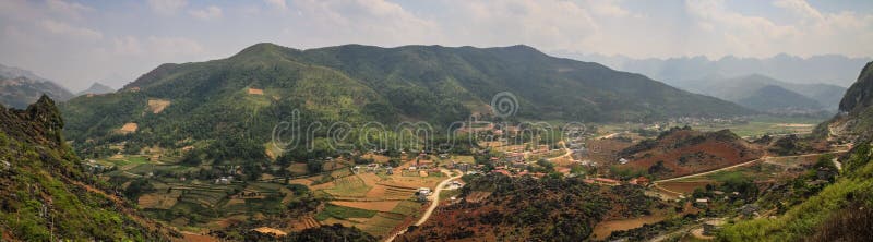
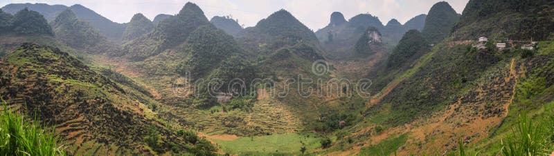
Free with trial Meo Vac is a small but charming district capital hemmed in by steep karst mountains and, like many towns in the northwest, it is steadily being settled by Vietnamese from elsewhere. The journey here along the spectacular Mai Pi Leng Pass, which winds for 22km from Van, is the main attraction. The road has been cut into the side of a cliff with a view of rippling hills tumbling down to the distant waters of the Nho Que River far below. Right at the top of the pass is a lookout point where you can stop to take in the scenery. Nho stock images, royalty-free photos and pictures Panorama of the majestic karst mountains around Meo Vac, Ha Giang Province, Vietnam. Meo Vac is a small but charming district capital hemmed in by steep karst mountains and, like many towns in the northwest, it is steadily being settled by Vietnamese from elsewhere. The journey here along the spectacular Mai Pi Leng Pass, which winds for 22km from Van, is the main attraction. The road has been cut into the side of a cliff with a view of rippling hills tumbling down to the distant waters of the Nho Que River far below. Right at the top of the pass is a lookout point where you can stop to take in the scenery.
Free with trial Meo Vac is a small but charming district capital hemmed in by steep karst mountains and, like many towns in the northwest, it is steadily being settled by Vietnamese from elsewhere. The journey here along the spectacular Mai Pi Leng Pass, which winds for 22km from Van, is the main attraction. The road has been cut into the side of a cliff with a view of rippling hills tumbling down to the distant waters of the Nho Que River far below. Right at the top of the pass is a lookout point where you can stop to take in the scenery. Nho stock images, royalty-free photos and pictures Panorama of the majestic karst mountains around Meo Vac, Ha Giang Province, Vietnam. Meo Vac is a small but charming district capital hemmed in by steep karst mountains and, like many towns in the northwest, it is steadily being settled by Vietnamese from elsewhere. The journey here along the spectacular Mai Pi Leng Pass, which winds for 22km from Van, is the main attraction. The road has been cut into the side of a cliff with a view of rippling hills tumbling down to the distant waters of the Nho Que River far below. Right at the top of the pass is a lookout point where you can stop to take in the scenery.
Free with trial On Ma Pi Leng pass, above Nho Que river in Van highland, Vietnam. Nho stock images, royalty-free photos and pictures On Ma Pi Leng pas
Free with trial On Ma Pi Leng pass, above Nho Que river in Van highland, Vietnam. Nho stock images, royalty-free photos and pictures On Ma Pi Leng pas
Free with trial On Ma Pi Leng pass, above Nho Que river in Van highland, Vietnam. Nho stock images, royalty-free photos and pictures On Ma Pi Leng pas
Free with trial Nho Que River Valley, Van, Ha Giang. The river splits as long 24km winding mountain. This is also the symbol of Ha Giang province, Vietnam. Nho stock images, royalty-free photos and pictures Nho Que River Valley, Van, Ha Giang
Free with trial Nho Que river valley on the rocky plateau of Ha Giang followed hills covered with green grass and cloud cover make nature more majestic than. Nho stock images, royalty-free photos and pictures Nho Que river valley on the rocky plateau of Ha Giang
Free with trial Green valley in Ha Giang, Vietnam. Ha Giang is a province in northeastern Vietnam. It is located in the far north of the country, and contains Vietnam`s northernmost point. Nho stock images, royalty-free photos and pictures Stunning view of the Nho Que river surrounded by mountains from the Ma Pi Leng pass. Green valley in Ha Giang, Vietnam. Ha Giang is a province in northeastern Vietnam. It is located in the far north of the country, and contains Vietnam`s northernmost point
Free with trial An aerial view of Nho Que River on Ha Giang loop, Vietnam. Nho stock images, royalty-free photos and pictures Aerial view of Nho Que River on Ha Giang loop, Vietnam.
Free with trial Vung Tau, Vietnam - February 25th, 2021: Statue of Jesus Christ standing on Mount Nho attracts pilgrims to visit and worship, the most popular local place in Vung Tau, Vietnam. Nho stock images, royalty-free photos and pictures Statue of Jesus Christ standing on Mount Nho attracts pilgrims to visit and worship
Free with trial Christ the King is a statue of Jesus, standing on Mount Nho, Vung Tau city, Vietnam. Nho stock images, royalty-free photos and pictures Vung Tau vietnam Jesus statue. Christ the King is a statue of Jesus, standing on Mount Nho, Vung Tau city, Vietnam
Free with trial Christ of Vung Tau is a statue of Jesus, located on Mount Nho in Vung Tau, Ba Ria-Vung Tau Province, Nam Bo, Vietnam. It was built in 1974 & completed in 1993. Nho stock images, royalty-free photos and pictures Jesus Statue - Vietnam, Vung Tau. Christ of Vung Tau is a statue of Jesus, located on Mount Nho in Vung Tau, Ba Ria-Vung Tau Province, Nam Bo, Vietnam. It was built in 1974 & completed in 1993.
Free with trial Tam Giac Mach is the name of flowers that always apear in autumn at Van Ha Giang North Vietnam. Nho stock images, royalty-free photos and pictures Tam Giac Mach Flowers Farm. Tam Giac Mach is the name of flowers that always apear in autumn at Van Ha Giang North Vietnam
Free with trial Flowers Farm in Van belongs to North Vietnam, a beautiful flowers farm in autumn. Nho stock images, royalty-free photos and pictures Tam Giac Mach Flowers Farm. Flowers Farm in Van belongs to North Vietnam, a beautiful flowers farm in autumn
Free with trial Mountain, road and cloud, blue sky at Lung Cu in Van stone. Van Stone Plateau (natural or painted Van) is a rocky plateau spread over four districts of Quan Ba, Yen Minh, Van, Meo Vac, Ha Giang province, Vietnam. Nho stock images, royalty-free photos and pictures Mountain, road and cloud, blue sky at Lung Cu
Free with trial Travel in Asia, Tham Ma, Ha Giang, Vietnam. Nho stock images, royalty-free photos and pictures Tham Ma, Ha Giang, Vietnam
Free with trial Mountains in northwest in vietnam. Nho stock images, royalty-free photos and pictures Landscape vietnam. Mountains in northwest in vietnam
Free with trial Bac Sum Slope Bac Sum Slope, this is the most dangerous place in Ha Giang connecting Minh Tan commune, Vi Xuyen district and Quyet Tien commune, Quan Ba district. From a distance, the Bac Sum slope looks like a soft fabric across the top of the mountain. Amidst the rocky cat-eared mountains, the Bac Sum slope looms in the mist. Cross the Bac Sum slope at Ha giang loop tour to enjoy the whole scene as beautiful as a water-colour painting. Nho stock images, royalty-free photos and pictures Bac Sum Slope - Ha Giang, Vietnam. Bac Sum Slope Bac Sum Slope, this is the most dangerous place in Ha Giang connecting Minh Tan commune, Vi Xuyen district and Quyet Tien commune, Quan Ba district.From a distance, the Bac Sum slope looks like a soft fabric across the top of the mountain. Amidst the rocky cat-eared mountains, the Bac Sum slope looms in the mist. Cross the Bac Sum slope at Ha giang loop tour to enjoy the whole scene as beautiful as a water-colour painting.
Free with trial Eclipta alba Urang-aring, false daisy, false daisy, yerba de tago, Karisalankanni, bhringraj with natural background. this plant is a species of plant in the sunflower family. Nho stock images, royalty-free photos and pictures Eclipta alba Urang-aring, false daisy, false daisy, yerba de tago, Karisalankanni, bhringraj with natural background. this plant
Free with trial Bac Sum Slope Bac Sum Slope, this is the most dangerous place in Ha Giang connecting Minh Tan commune, Vi Xuyen district and Quyet Tien commune, Quan Ba district. From a distance, the Bac Sum slope looks like a soft fabric across the top of the mountain. Amidst the rocky cat-eared mountains, the Bac Sum slope looms in the mist. Cross the Bac Sum slope at Ha giang loop tour to enjoy the whole scene as beautiful as a water-colour painting. Nho stock images, royalty-free photos and pictures Bac Sum Slope - Ha Giang, Vietnam. Bac Sum Slope Bac Sum Slope, this is the most dangerous place in Ha Giang connecting Minh Tan commune, Vi Xuyen district and Quyet Tien commune, Quan Ba district.From a distance, the Bac Sum slope looks like a soft fabric across the top of the mountain. Amidst the rocky cat-eared mountains, the Bac Sum slope looms in the mist. Cross the Bac Sum slope at Ha giang loop tour to enjoy the whole scene as beautiful as a water-colour painting.
Free with trial Eclipta alba Urang-aring, false daisy, false daisy, yerba de tago, Karisalankanni, bhringraj with natural background. this plant is a species of plant in the sunflower family. Weeds. Nho stock images, royalty-free photos and pictures Eclipta alba Urang-aring, false daisy, false daisy, yerba de tago, Karisalankanni, bhringraj with natural background. this plant
Free with trial Eclipta alba Urang-aring, false daisy, false daisy, yerba de tago, Karisalankanni, bhringraj with natural background. this plant is a species of plant in the sunflower family. Weeds. Nho stock images, royalty-free photos and pictures Eclipta alba Urang-aring, false daisy, false daisy, yerba de tago, Karisalankanni, bhringraj with natural background. this plant
Free with trial Lung Cu Flag Tower in Ha GiangLung Cu Flag Tower is not only a popular tourist destination in Vietnam but also serves as a reminder of the rich cultural heritage of this renowned siteLung Cu Flag Tower is an iconic structure situated in Ha Giang province, Vietnam. Positioned at the northernmost point of the country, it is marked as a symbol of national unity and independence. With its striking red and yellow flag representing Vietnam, the tower offers panoramic views of the surrounding areas. Visiting Lung Cu Flag Tower is an opportunity to experience the natural beauty and cultural significance of the region. Nho stock images, royalty-free photos and pictures Lung Cu Flag Tower in Ha Giang, Vietnam. Lung Cu Flag Tower in Ha GiangLung Cu Flag Tower is not only a popular tourist destination in Vietnam but also serves as a reminder of the rich cultural heritage of this renowned siteLung Cu Flag Tower is an iconic structure situated in Ha Giang province, Vietnam. Positioned at the northernmost point of the country, it is marked as a symbol of national unity and independence. With its striking red and yellow flag representing Vietnam, the tower offers panoramic views of the surrounding areas. Visiting Lung Cu Flag Tower is an opportunity to experience the natural beauty and cultural significance of the region.
Free with trial Home of ethnic minorities. Ha Giang is one of the six poorest provinces of Vietnam. Ha Giang is a famous tourist destination in Vietnam. Photo taken on: 03 May 2011. Nho stock images, royalty-free photos and pictures Home of ethnic minorities
Free with trial Home of ethnic minorities. Ha Giang is one of the six poorest provinces of Vietnam. Ha Giang is a famous tourist destination in Vietnam. Photo taken on: 03 May 2011. Nho stock images, royalty-free photos and pictures Home of ethnic minorities
Free with trial Home of ethnic minorities. Ha Giang is one of the six poorest provinces of Vietnam. Ha Giang is a famous tourist destination in Vietnam. Photo taken on: 03 May 2011. Nho stock images, royalty-free photos and pictures Home of ethnic minorities
Free with trial Gate, home of ethnic minorities. Ha Giang is one of the six poorest provinces of Vietnam. Ha Giang is a famous tourist destination in Vietnam. Photo taken on: 03 May 2011. Nho stock images, royalty-free photos and pictures Gate, home of ethnic minorities
Free with trial Mountain, road and cloud, blue sky at Lung Cu in Van stone. Van Stone Plateau (natural or painted Van) is a rocky plateau spread over four districts of Quan Ba, Yen Minh, Van, Meo Vac, Ha Giang province, Vietnam. October 3, 2010, records Geoparks Van Stone Plateau was an advisory council Network Global Geoparks (GGN) of UNESCO officially recognized as a global geopark. This is currently the only title in Vietnam and Southeast Asia's second. Nho stock images, royalty-free photos and pictures Mountain, road and cloud, blue sky at Lung Cu
Free with trial Mountain and Happy road at Ma Pi Leng in Van stone. Van Stone Plateau (natural or painted Van) is a rocky plateau spread over four districts of Quan Ba, Yen Minh, Van, Meo Vac, Ha Giang province, Vietnam. October 3, 2010, records Geoparks Van Stone Plateau was an advisory council Network Global Geoparks (GGN) of UNESCO officially recognized as a global geopark. This is currently the only title in Vietnam and Southeast Asia's second. Nho stock images, royalty-free photos and pictures Mountain and Happy road at Ma Pi Leng
Free with trial Nho Que River boat cruise view in Ha Giang, Northern Vietnam. Popular Ha Giang Loop tour route scenery in Vietnam. Nho stock images, royalty-free photos and pictures Nho Que River boat cruise view in Ha Giang, Northern Vietnam. Popular Ha Giang Loop tour route scenery in Vietnam
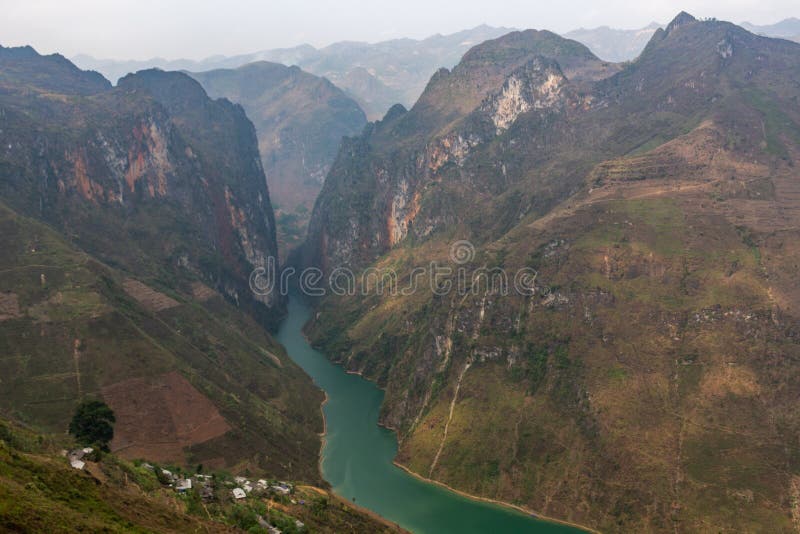
Free with trial Nho Que River�is a captivating gem of�Ha Giang, winding through rugged limestone mountains and deep canyons, especially Tu San Canyon. Beyond its natural beauty, the river holds cultural significance, reflecting the life and traditions of the ethnic communities along its banks. This article will give you all the key information you need for a seamless and enriching visit to this Nho Que Rive. Nho stock images, royalty-free photos and pictures Nho Que River - A Jewel of Ha Giang& x27;s Stone Plateau. Nho Que River�is a captivating gem of�Ha Giang, winding through rugged limestone mountains and deep canyons, especially Tu San Canyon. Beyond its natural beauty, the river holds cultural significance, reflecting the life and traditions of the ethnic communities along its banks. This article will give you all the key information you need for a seamless and enriching visit to this Nho Que Rive
Free with trial Nho Que RiverNho Que River, situated at the base of Ma Pi Leng Pass, is among renowned Ha Giang attractions and the most captivating rivers in Vietnam. When observed from above, it resembles a glistening green thread nestled amidst the mountains. Embarking on a boat tour along the river offers visitors an opportunity to appreciate its enchanting beauty and indulge in special photo stops as they navigate Tu San Alley, acknowledged as one of the deepest canyons in Southeast Asia. Nho stock images, royalty-free photos and pictures Tu San Alley, - Nho Que River- Ha Giang, Vietnam. Nho Que RiverNho Que River, situated at the base of Ma Pi Leng Pass, is among renowned Ha Giang attractions and the most captivating rivers in Vietnam. When observed from above, it resembles a glistening green thread nestled amidst the mountains.Embarking on a boat tour along the river offers visitors an opportunity to appreciate its enchanting beauty and indulge in special photo stops as they navigate Tu San Alley, acknowledged as one of the deepest canyons in Southeast Asia.
Free with trial This captivating photograph showcases the dramatic landscape of Tu San Gorge in Ha Giang, Vietnam, with the Nho Que River winding its way through the steep, towering cliffs. Nho stock images, royalty-free photos and pictures Nho Que River and Tu San Canyon. Ha Giang, Vietnam. This captivating photograph showcases the dramatic landscape of Tu San Gorge in Ha Giang, Vietnam, with the Nho Que River winding its way through the steep, towering cliffs
Free with trial This captivating photograph showcases the dramatic landscape of Tu San Gorge in Ha Giang, Vietnam, with the Nho Que River winding its way through the steep, towering cliffs. Nho stock images, royalty-free photos and pictures Nho Que River and Tu San Canyon. Ha Giang, Vietnam. This captivating photograph showcases the dramatic landscape of Tu San Gorge in Ha Giang, Vietnam, with the Nho Que River winding its way through the steep, towering cliffs
Free with trial Ma Pi Leng Pass - Ha Giang, VietnamMa Pi Leng, a rugged mountain pass spanning approximately 20 kilometers, is a prominent feature of Ha Giang. Connecting Ha Giang City, Dong Van District, and Meo Vac District, Ma Pi Leng derives its name from Mandarin, translating to �horse�s nose�. The pass traverses perilous cliffs, reaching a height of 2,000 meters at the peak, while at the base lies the deep valley of Nho Que River. Nho Que RiverNho Que River, situated at the base of Ma Pi Leng Pass, is among renowned Ha Giang attractions and the most captivating rivers in Vietnam. When observed from above, it resembles a glistening green thread nestled amidst the mountains. Embarking on a boat tour along the river offers visitors an opportunity to appreciate its enchanting beauty and indulge in special photo stops as they navigate Tu San Alley, acknowledged as one of the deepest canyons in Southeast Asia. Nho stock images, royalty-free photos and pictures Ma Pi Leng Pass - Nho Que River - Ha Giang, Vietnam. Ma Pi Leng Pass - Ha Giang, VietnamMa Pi Leng, a rugged mountain pass spanning approximately 20 kilometers, is a prominent feature of Ha Giang. Connecting Ha Giang City, Dong Van District, and Meo Vac District, Ma Pi Leng derives its name from Mandarin, translating to �horse�s nose�. The pass traverses perilous cliffs, reaching a height of 2,000 meters at the peak, while at the base lies the deep valley of Nho Que River.Nho Que RiverNho Que River, situated at the base of Ma Pi Leng Pass, is among renowned Ha Giang attractions and the most captivating rivers in Vietnam. When observed from above, it resembles a glistening green thread nestled amidst the mountains.Embarking on a boat tour along the river offers visitors an opportunity to appreciate its enchanting beauty and indulge in special photo stops as they navigate Tu San Alley, acknowledged as one of the deepest canyons in Southeast Asia.
Free with trial Ma Pi Leng Pass - Ha Giang, VietnamMa Pi Leng, a rugged mountain pass spanning approximately 20 kilometers, is a prominent feature of Ha Giang. Connecting Ha Giang City, Dong Van District, and Meo Vac District, Ma Pi Leng derives its name from Mandarin, translating to �horse�s nose�. The pass traverses perilous cliffs, reaching a height of 2,000 meters at the peak, while at the base lies the deep valley of Nho Que River. Nho Que RiverNho Que River, situated at the base of Ma Pi Leng Pass, is among renowned Ha Giang attractions and the most captivating rivers in Vietnam. When observed from above, it resembles a glistening green thread nestled amidst the mountains. Embarking on a boat tour along the river offers visitors an opportunity to appreciate its enchanting beauty and indulge in special photo stops as they navigate Tu San Alley, acknowledged as one of the deepest canyons in Southeast Asia. Nho stock images, royalty-free photos and pictures Ma Pi Leng Pass - Nho Que River - Ha Giang, Vietnam. Ma Pi Leng Pass - Ha Giang, VietnamMa Pi Leng, a rugged mountain pass spanning approximately 20 kilometers, is a prominent feature of Ha Giang. Connecting Ha Giang City, Dong Van District, and Meo Vac District, Ma Pi Leng derives its name from Mandarin, translating to �horse�s nose�. The pass traverses perilous cliffs, reaching a height of 2,000 meters at the peak, while at the base lies the deep valley of Nho Que River.Nho Que RiverNho Que River, situated at the base of Ma Pi Leng Pass, is among renowned Ha Giang attractions and the most captivating rivers in Vietnam. When observed from above, it resembles a glistening green thread nestled amidst the mountains.Embarking on a boat tour along the river offers visitors an opportunity to appreciate its enchanting beauty and indulge in special photo stops as they navigate Tu San Alley, acknowledged as one of the deepest canyons in Southeast Asia.
Free with trial Nho Que RiverNho Que River, situated at the base of Ma Pi Leng Pass, is among renowned Ha Giang attractions and the most captivating rivers in Vietnam. When observed from above, it resembles a glistening green thread nestled amidst the mountains. Embarking on a boat tour along the river offers visitors an opportunity to appreciate its enchanting beauty and indulge in special photo stops as they navigate Tu San Alley, acknowledged as one of the deepest canyons in Southeast Asia. Nho stock images, royalty-free photos and pictures Nho Que River- Ha Giang, Vietnam. Nho Que RiverNho Que River, situated at the base of Ma Pi Leng Pass, is among renowned Ha Giang attractions and the most captivating rivers in Vietnam. When observed from above, it resembles a glistening green thread nestled amidst the mountains.Embarking on a boat tour along the river offers visitors an opportunity to appreciate its enchanting beauty and indulge in special photo stops as they navigate Tu San Alley, acknowledged as one of the deepest canyons in Southeast Asia.
Free with trial Nho Que RiverNho Que River, situated at the base of Ma Pi Leng Pass, is among renowned Ha Giang attractions and the most captivating rivers in Vietnam. When observed from above, it resembles a glistening green thread nestled amidst the mountains. Embarking on a boat tour along the river offers visitors an opportunity to appreciate its enchanting beauty and indulge in special photo stops as they navigate Tu San Alley, acknowledged as one of the deepest canyons in Southeast Asia. Nho stock images, royalty-free photos and pictures Nho Que River- Ha Giang, Vietnam. Nho Que RiverNho Que River, situated at the base of Ma Pi Leng Pass, is among renowned Ha Giang attractions and the most captivating rivers in Vietnam. When observed from above, it resembles a glistening green thread nestled amidst the mountains.Embarking on a boat tour along the river offers visitors an opportunity to appreciate its enchanting beauty and indulge in special photo stops as they navigate Tu San Alley, acknowledged as one of the deepest canyons in Southeast Asia.
Free with trial Nho Que RiverNho Que River, situated at the base of Ma Pi Leng Pass, is among renowned Ha Giang attractions and the most captivating rivers in Vietnam. When observed from above, it resembles a glistening green thread nestled amidst the mountains. Embarking on a boat tour along the river offers visitors an opportunity to appreciate its enchanting beauty and indulge in special photo stops as they navigate Tu San Alley, acknowledged as one of the deepest canyons in Southeast Asia. Nho stock images, royalty-free photos and pictures Nho Que River- Ha Giang, Vietnam. Nho Que RiverNho Que River, situated at the base of Ma Pi Leng Pass, is among renowned Ha Giang attractions and the most captivating rivers in Vietnam. When observed from above, it resembles a glistening green thread nestled amidst the mountains.Embarking on a boat tour along the river offers visitors an opportunity to appreciate its enchanting beauty and indulge in special photo stops as they navigate Tu San Alley, acknowledged as one of the deepest canyons in Southeast Asia.
Free with trial Nho Que River boat cruise view in Ha Giang, Northern Vietnam. Popular Ha Giang Loop tour route scenery in Vietnam. Nho stock images, royalty-free photos and pictures Nho Que River boat cruise view in Ha Giang, Northern Vietnam. Popular Ha Giang Loop tour route scenery in Vietnam
Free with trial Nho Que River boat cruise view in Ha Giang, Northern Vietnam. Popular Ha Giang Loop tour route scenery in Vietnam. Nho stock images, royalty-free photos and pictures Nho Que River boat cruise view in Ha Giang, Northern Vietnam. Popular Ha Giang Loop tour route scenery in Vietnam
Free with trial Nho Que River boat cruise view in Ha Giang, Northern Vietnam. Popular Ha Giang Loop tour route scenery in Vietnam. Nho stock images, royalty-free photos and pictures Nho Que River boat cruise view in Ha Giang, Northern Vietnam. Popular Ha Giang Loop tour route scenery in Vietnam.
Free with trial STAVANGER, NORWAY - JULY 20, 2020: Naeringslivets Hus office building in Stavanger. Its tenants are Naeringslivets Hovedorganisasjon NHO (business association), ONS, Pareto and Haver. Nho stock images, royalty-free photos and pictures Naeringslivets Hovedorganisasjon NHO
Free with trial A stunning aerial view of the Ma Pi Leng Pass, one of the most scenic mountain roads in northern Vietnam. The emerald Nho Que River winds through towering limestone mountains. Nho stock images, royalty-free photos and pictures Breathtaking View of Ma Pi Leng Pass in Vietnam. A stunning aerial view of the Ma Pi Leng Pass, one of the most scenic mountain roads in northern Vietnam. The emerald Nho Que River winds through towering limestone mountains.
Free with trial Ha Giang landscape with Nho Que river between mountains in Ha Giang, Vietnam, a popular tourist destination in Vietnam. Nho stock images, royalty-free photos and pictures Ha Giang landscape with Nho Que river between mountains in Ha Giang, Vietnam, a popular tourist destination in Vietnam
Free with trial Ha Giang landscape with Nho Que river between mountains in Ha Giang , Vietnam, a popular tourist destination in Vietnam. Nho stock images, royalty-free photos and pictures Ha Giang landscape with Nho Que river between mountains in Ha Giang , Vietnam. Ha Giang landscape with Nho Que river between mountains in Ha Giang , Vietnam, a popular tourist destination in Vietnam
Free with trial Mountain and River Landscape with Motorbike Riders on Winding Roads in Ha Giang Loop, Northern Vietnam. Nho stock images, royalty-free photos and pictures Nho Que river. Mountain and River Landscape with Motorbike Riders on Winding Roads in Ha Giang Loop, Northern Vietnam
Free with trial Mountain and River Landscape with Motorbike Riders on Winding Roads in Ha Giang Loop, Northern Vietnam. Nho stock images, royalty-free photos and pictures Nho Que river in Ha Giang, Vietnam. Mountain and River Landscape with Motorbike Riders on Winding Roads in Ha Giang Loop, Northern Vietnam
Free with trial Sooty-headed bulbuls Pycnonotus aurigaster. Nho Quan district. Ninh Binh Province. Vietnam. Nho stock images, royalty-free photos and pictures Sooty-headed bulbuls Pycnonotus aurigaster
Free with trial Ha Giang, Vietnam: Where majestic nature meetsNestled in the northern region of Vietnam, Ha Giang, Vietnam beckons adventurers with its awe-inspiring landscapes and rich cultural tapestry. This captivating province offers challenging mountain trails, lush greenery, and colorful ethnic villages. Ma Pi Leng Pass - Ha Giang, VietnamMa Pi Leng, a rugged mountain pass spanning approximately 20 kilometers, is a prominent feature of Ha Giang. Connecting Ha Giang City, Dong Van District, and Meo Vac District, Ma Pi Leng derives its name from Mandarin, translating to �horse�s nose�. The pass traverses perilous cliffs, reaching a height of 2,000 meters at the peak, while at the base lies the deep valley of Nho Que River. Nho Que RiverNho Que River, situated at the base of Ma Pi Leng Pass, is among renowned Ha Giang attractions and the most captivating rivers in Vietnam. When observed from above, it resembles a glistening green thread nestled amidst the mountains. Embarking on a boat tour along the river offers visitors an opportunity to appreciate its enchanting beauty and indulge in special photo stops as they navigate Tu San Alley, acknowledged as one of the deepest canyons in Southeast Asia. Nho stock images, royalty-free photos and pictures Ma Pi Leng Pass - Ha Giang, Vietnam: Where majestic nature meets. Ha Giang, Vietnam: Where majestic nature meetsNestled in the northern region of Vietnam, Ha Giang, Vietnam beckons adventurers with its awe-inspiring landscapes and rich cultural tapestry. This captivating province offers challenging mountain trails, lush greenery, and colorful ethnic villages.Ma Pi Leng Pass - Ha Giang, VietnamMa Pi Leng, a rugged mountain pass spanning approximately 20 kilometers, is a prominent feature of Ha Giang. Connecting Ha Giang City, Dong Van District, and Meo Vac District, Ma Pi Leng derives its name from Mandarin, translating to �horse�s nose�. The pass traverses perilous cliffs, reaching a height of 2,000 meters at the peak, while at the base lies the deep valley of Nho Que River.Ma Pi Leng Pass - Ha Giang, VietnamMa Pi Leng, a rugged mountain pass spanning approximately 20 kilometers, is a prominent feature of Ha Giang. Connecting Ha Giang City, Dong Van District, and Meo Vac District, Ma Pi Leng derives its name from Mandarin, translating to �horse�s nose�. The pass traverses perilous cliffs, reaching a height of 2,000 meters at the peak, while at the base lies the deep valley of Nho Que River.Nho Que RiverNho Que River, situated at the base of Ma Pi Leng Pass, is among renowned Ha Giang attractions and the most captivating rivers in Vietnam. When observed from above, it resembles a glistening green thread nestled amidst the mountains.Embarking on a boat tour along the river offers visitors an opportunity to appreciate its enchanting beauty and indulge in special photo stops as they navigate Tu San Alley, acknowledged as one of the deepest canyons in Southeast Asia.
Free with trial Stunning landscape of nho que river with low clouds covering the mountains in cao bang province, vietnam. Nho stock images, royalty-free photos and pictures Clouds embracing green mountains over the river in cao bang, vietnam. Stunning landscape of nho que river with low clouds covering the mountains in cao bang province, vietnam
Free with trial Ha Giang landscape with Nho Que river between mountains in Ha Giang , Vietnam, a popular tourist destination in Vietnam. Nho stock images, royalty-free photos and pictures Ha Giang landscape with Nho Que river between mountains in Ha Giang , Vietnam. Ha Giang landscape with Nho Que river between mountains in Ha Giang , Vietnam, a popular tourist destination in Vietnam
Free with trial Ha Giang landscape with Nho Que river between mountains in Ha Giang , Vietnam, a popular tourist destination in Vietnam. Nho stock images, royalty-free photos and pictures Ha Giang landscape with Nho Que river between mountains in Ha Giang , Vietnam. Ha Giang landscape with Nho Que river between mountains in Ha Giang , Vietnam, a popular tourist destination in Vietnam
Free with trial Ha Giang landscape with Nho Que river between mountains in Ha Giang , Vietnam, a popular tourist destination in Vietnam. Nho stock images, royalty-free photos and pictures Ha Giang landscape with Nho Que river between mountains in Ha Giang , Vietnam. Ha Giang landscape with Nho Que river between mountains in Ha Giang , Vietnam, a popular tourist destination in Vietnam
Free with trial Ha Giang landscape with Nho Que river between mountains in Ha Giang , Vietnam, a popular tourist destination in Vietnam. Nho stock images, royalty-free photos and pictures Ha Giang landscape with Nho Que river between mountains in Ha Giang , Vietnam. Ha Giang landscape with Nho Que river between mountains in Ha Giang , Vietnam, a popular tourist destination in Vietnam
Free with trial Ha Giang landscape with Nho Que river between mountains in Ha Giang , Vietnam, a popular tourist destination in Vietnam. Nho stock images, royalty-free photos and pictures Ha Giang landscape with Nho Que river between mountains in Ha Giang , Vietnam. Ha Giang landscape with Nho Que river between mountains in Ha Giang , Vietnam, a popular tourist destination in Vietnam
Free with trial Ha Giang landscape with Nho Que river between mountains in Ha Giang , Vietnam, a popular tourist destination in Vietnam. Nho stock images, royalty-free photos and pictures Ha Giang landscape with Nho Que river between mountains in Ha Giang , Vietnam. Ha Giang landscape with Nho Que river between mountains in Ha Giang , Vietnam, a popular tourist destination in Vietnam
Free with trial Ha Giang, Vietnam: Where majestic nature meetsNestled in the northern region of Vietnam, Ha Giang, Vietnam beckons adventurers with its awe-inspiring landscapes and rich cultural tapestry. This captivating province offers challenging mountain trails, lush greenery, and colorful ethnic villages. Ma Pi Leng Pass - Ha Giang, VietnamMa Pi Leng, a rugged mountain pass spanning approximately 20 kilometers, is a prominent feature of Ha Giang. Connecting Ha Giang City, Dong Van District, and Meo Vac District, Ma Pi Leng derives its name from Mandarin, translating to �horse�s nose�. The pass traverses perilous cliffs, reaching a height of 2,000 meters at the peak, while at the base lies the deep valley of Nho Que River. Nho stock images, royalty-free photos and pictures Ha Giang, Vietnam: Where majestic nature meets
Free with trial Ha Giang, Vietnam: Where majestic nature meetsNestled in the northern region of Vietnam, Ha Giang, Vietnam beckons adventurers with its awe-inspiring landscapes and rich cultural tapestry. This captivating province offers challenging mountain trails, lush greenery, and colorful ethnic villages. Ma Pi Leng Pass - Ha Giang, VietnamMa Pi Leng, a rugged mountain pass spanning approximately 20 kilometers, is a prominent feature of Ha Giang. Connecting Ha Giang City, Dong Van District, and Meo Vac District, Ma Pi Leng derives its name from Mandarin, translating to �horse�s nose�. The pass traverses perilous cliffs, reaching a height of 2,000 meters at the peak, while at the base lies the deep valley of Nho Que River. Nho stock images, royalty-free photos and pictures Ha Giang, Vietnam: Where majestic nature meets
Free with trial Ha Giang, Vietnam: Where majestic nature meetsNestled in the northern region of Vietnam, Ha Giang, Vietnam beckons adventurers with its awe-inspiring landscapes and rich cultural tapestry. This captivating province offers challenging mountain trails, lush greenery, and colorful ethnic villages. Ma Pi Leng Pass - Ha Giang, VietnamMa Pi Leng, a rugged mountain pass spanning approximately 20 kilometers, is a prominent feature of Ha Giang. Connecting Ha Giang City, Dong Van District, and Meo Vac District, Ma Pi Leng derives its name from Mandarin, translating to �horse�s nose�. The pass traverses perilous cliffs, reaching a height of 2,000 meters at the peak, while at the base lies the deep valley of Nho Que River. Nho stock images, royalty-free photos and pictures Ha Giang, Vietnam: Where majestic nature meets
Free with trial Ha Giang, Vietnam: Where majestic nature meetsNestled in the northern region of Vietnam, Ha Giang, Vietnam beckons adventurers with its awe-inspiring landscapes and rich cultural tapestry. This captivating province offers challenging mountain trails, lush greenery, and colorful ethnic villages. Ma Pi Leng Pass - Ha Giang, VietnamMa Pi Leng, a rugged mountain pass spanning approximately 20 kilometers, is a prominent feature of Ha Giang. Connecting Ha Giang City, Dong Van District, and Meo Vac District, Ma Pi Leng derives its name from Mandarin, translating to �horse�s nose�. The pass traverses perilous cliffs, reaching a height of 2,000 meters at the peak, while at the base lies the deep valley of Nho Que River. Nho stock images, royalty-free photos and pictures Ha Giang, Vietnam: Where majestic nature meets
Free with trial Ha Giang, Vietnam: Where majestic nature meetsNestled in the northern region of Vietnam, Ha Giang, Vietnam beckons adventurers with its awe-inspiring landscapes and rich cultural tapestry. This captivating province offers challenging mountain trails, lush greenery, and colorful ethnic villages. Ma Pi Leng Pass - Ha Giang, VietnamMa Pi Leng, a rugged mountain pass spanning approximately 20 kilometers, is a prominent feature of Ha Giang. Connecting Ha Giang City, Dong Van District, and Meo Vac District, Ma Pi Leng derives its name from Mandarin, translating to �horse�s nose�. The pass traverses perilous cliffs, reaching a height of 2,000 meters at the peak, while at the base lies the deep valley of Nho Que River. Nho stock images, royalty-free photos and pictures Ha Giang, Vietnam: Where majestic nature meets