Free with trial Ziro, Arunachal Pradesh/India - December 14, 2013: Woman from the Apatani tribe, with nose plugs, The Apatani are a tribal group of people living in the Ziro valley in Arunachal Pradesh, India. Tani stock images, royalty-free photos and pictures Apatani Tribe
Free with trial Ziro, Arunachal Pradesh/India - December 14, 2013: Woman from the Apatani tribe, with nose plugs, The Apatani are a tribal group of people living in the Ziro valley in Arunachal Pradesh, India. Tani stock images, royalty-free photos and pictures Apatani Tribe
Free with trial SHIRETOKO NATIONAL PARK, JAPAN - AUGUST 10, 2017: The natural hotspring-fed warm waters of Kamuiwakka Falls draw visitors to walk through its waters on a summer day in this World Heritage Site in the remote north of Hokkaido, Japan. Tani stock images, royalty-free photos and pictures Tourists at Kamuiwakka Falls, Shiretoko. SHIRETOKO NATIONAL PARK, JAPAN - AUGUST 10, 2017: The natural hotspring-fed warm waters of Kamuiwakka Falls draw visitors to walk through its waters on a summer day in this World Heritage Site in the remote north of Hokkaido, Japan
Free with trial Kluai Tani Dang, Musa balbisiana Colla. , Musa martini Van Geert or banana tree or bicolor banana plant. Tani stock images, royalty-free photos and pictures Kluai Tani Dang, Musa balbisiana Colla., Musa martini Van Geert or banana tree or bicolor banana
Free with trial Selangor, Malaysia - November 3, 2019: Aerial view of Bandar Baru Bangi city in the morning. Pasar Tani or farmer`s market along the road. Tani stock images, royalty-free photos and pictures Selangor, Malaysia - November 3, 2019: Aerial view of Bandar Baru Bangi city in the morning. Pasar Tani or farmer`s market along
Free with trial Doha, Qatar - Nov 21. 2019. Portrait of the Emir of Qatar Sheikh Tamim bin Hamad bin Khalifa Al Tani on Skyscrapers of West Bay. Tani stock images, royalty-free photos and pictures Doha, Qatar - Nov 21. 2019. Portrait of Emir of Qatar Sheikh Tamim bin Hamad bin Khalifa Al Tani on Skyscrapers of West
Free with trial Selangor, Malaysia - November 3, 2019: Aerial view of Bandar Baru Bangi city in the morning. Pasar Tani or farmer`s market along the road. Tani stock images, royalty-free photos and pictures Aerial view of Bandar Baru Bangi city in the morning. Pasar Tani or farmer`s market along
Free with trial Wisma tani is one of the building have at Putrajaya, Malaysia. Agriculture Ministery. Tani stock images, royalty-free photos and pictures WISMA TANI, PUTRAJAYA. Wisma tani is one of the building have at Putrajaya, Malaysia. Agriculture Ministery.
Free with trial A stupa containing the relics of Lord Buddha at wat Pho Somporn Udon Tani Thailand. Tani stock images, royalty-free photos and pictures The pagoda of Pho Somporn. A stupa containing the relics of Lord Buddha at wat Pho Somporn Udon Tani Thailand
Free with trial Is a fern from the group known as bird's nest ferns. In Japanese, it is known as? -tani-watari and tani-watari. Grows on cliffs, in dark forests and on tree trunks in China, Japan, Korea and Taiwan. Tani stock images, royalty-free photos and pictures Is a fern from the group known as bird\'s nest ferns. In Japanese. is a fern from the group known as bird's nest ferns. In Japanese, it is known as ?-tani-watari and tani-watari. Grows on cliffs, in dark forests and on tree trunks in China, Japan, Korea and Taiwan
Free with trial Selangor, Malaysia - November 3, 2019: Aerial view of Bandar Baru Bangi city in the morning. Pasar Tani or farmer`s market along the road. Tani stock images, royalty-free photos and pictures Selangor, Malaysia - November 3, 2019: Aerial view of Bandar Baru Bangi city in the morning. Pasar Tani or farmer`s market along
Free with trial Selangor, Malaysia - November 3, 2019: Aerial view of Bandar Baru Bangi city in the morning. Pasar Tani or farmer`s market along the road. Tani stock images, royalty-free photos and pictures Selangor, Malaysia - November 3, 2019: Aerial view of Bandar Baru Bangi city in the morning. Pasar Tani or farmer`s market along
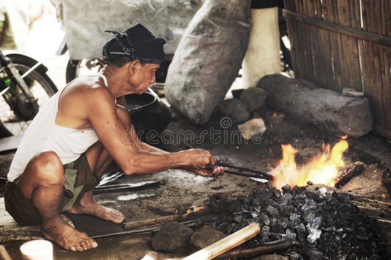
Free with trial A blackmith make implements with traditional tool in Central Java-Indonesia. Tani stock images, royalty-free photos and pictures Traditional Blacksmith. A blackmith make implements with traditional tool in Central Java-Indonesia
Free with trial Thai fishing Boat in Tani river,Pattani province,Thailand. Tani stock images, royalty-free photos and pictures Thai fishing Boat
Free with trial Banana flower Banana inflorescence and leaves on the tree. Tani stock images, royalty-free photos and pictures Banana flower Banana inflorescence
Free with trial Night view from a barred window, shadows of trees with yellow light. Tani stock images, royalty-free photos and pictures Night view from a window with a lattice. Night view from a barred window, shadows of trees with yellow light
Free with trial Ziro, Arunachal Pradesh/India - December 13, 2013: Woman from the Apatani tribe. The Apatani are a tribal group of people living in the Ziro valley in Arunachal Pradesh, India. Tani stock images, royalty-free photos and pictures Apatani Tribe Woman. Ziro, Arunachal Pradesh/India - December 13, 2013: Woman from the Apatani tribe. The Apatani are a tribal group of people living in the Ziro valley in Arunachal Pradesh, India.
Free with trial Ziro, Arunachal Pradesh/India - December 14, 2013: Women from the Apatani tribe, with nose plugs, The Apatani are a tribal group of people living in the Ziro valley in Arunachal Pradesh, India. Tani stock images, royalty-free photos and pictures Apatani Tribe
Free with trial Ziro, Arunachal Pradesh/India - December 14, 2013: Women from the Apatani tribe, with nose plugs, The Apatani are a tribal group of people living in the Ziro valley in Arunachal Pradesh, India. Tani stock images, royalty-free photos and pictures Apatani Tribe
Free with trial Ziro, Arunachal Pradesh/India - December 14, 2013: Woman from the Apatani tribe, with nose plugs, The Apatani are a tribal group of people living in the Ziro valley in Arunachal Pradesh, India. Tani stock images, royalty-free photos and pictures Apatani Tribe
Free with trial Ziro, Arunachal Pradesh/India - December 13, 2013: Man from the Apatani tribe. The Apatani are a tribal group of people living in the Ziro valley in Arunachal Pradesh, India. Tani stock images, royalty-free photos and pictures Apatani Tribe
Free with trial Ziro, Arunachal Pradesh/India - December 14, 2013: Women from the Apatani tribe, with nose plugs, The Apatani are a tribal group of people living in the Ziro valley in Arunachal Pradesh, India. Tani stock images, royalty-free photos and pictures Apatani Tribe
Free with trial Ziro, Arunachal Pradesh/India - December 13, 2013: Woman from the Apatani tribe, with nose plugs, The Apatani are a tribal group of people living in the Ziro valley in Arunachal Pradesh, India. Tani stock images, royalty-free photos and pictures Apatani Tribe
Free with trial Ziro, Arunachal Pradesh/India - December 14, 2013: Man of the Apatani tribe. The Apatani are a tribal group of people living in the Ziro valley in Arunachal Pradesh, India. Tani stock images, royalty-free photos and pictures Apatani Tribe
Free with trial Ziro, Arunachal Pradesh/India - December 13, 2013: Woman from the Apatani tribe, with nose plugs, The Apatani are a tribal group of people living in the Ziro valley in Arunachal Pradesh, India. Tani stock images, royalty-free photos and pictures Apatani Tribe
Free with trial BANGKOK, THAILAND - APRIL 23, 2019: Crocodile BBQ on the showcase of the restaurant on Khaosan Road, on April 23 in Bangkok, Thailand. Tani stock images, royalty-free photos and pictures Crocodile BBQ on the showcase of the restaurant on Khaosan Road in Bangkok, Thailand. BANGKOK, THAILAND - APRIL 23, 2019: Crocodile BBQ on the showcase of the restaurant on Khaosan Road, on April 23 in Bangkok, Thailand
Free with trial BANGKOK, THAILAND - APRIL 23, 2019: Rambuttri Alley is neighbouring with Khaosan Road and is the heaven for food and drink lovers, on April 23 in Bangkok. Tani stock images, royalty-free photos and pictures Rambuttri Alley is neighbouring with Khaosan Road and is the heaven for food and drink lovers, Bangkok, Thailand. BANGKOK, THAILAND - APRIL 23, 2019: Rambuttri Alley is neighbouring with Khaosan Road and is the heaven for food and drink lovers, on April 23 in Bangkok
Free with trial IMSA Official, waves the checkered flag, ending the days session for the Bubba Burger Sports Car Grand Prix At Long Beach in Long Beach, California. Tani stock images, royalty-free photos and pictures IMSA: April 07 Bubba Burger Sports Car Grand Prix At Long Beach. IMSA Official, waves the checkered flag, ending the days session for the Bubba Burger Sports Car Grand Prix At Long Beach in Long Beach, California.
Free with trial Upper part of the Stele of Tani, Late Period, late 25th to early 26th Dynasty, ca. 660-650 BC. High-resolution images capturing iconic items displayed at the Kunsthistorisches Museum in Vienna, Austria. These photos highlight artistic brilliance from Ancient Egypt and Greece through to the Baroque period. Tani stock images, royalty-free photos and pictures Upper part of the Stele of Tani, c.650 BC, Kunsthistorisches Museum, Vienna, Austria. Upper part of the Stele of Tani, Late Period, late 25th to early 26th Dynasty, ca. 660-650 BC. High-resolution images capturing iconic items displayed at the Kunsthistorisches Museum in Vienna, Austria. These photos highlight artistic brilliance from Ancient Egypt and Greece through to the Baroque period.
Free with trial A bustling view of Jakarta's Tugu Tani roundabout, featuring numerous vehicles navigating the circular traffic. The foreground shows meticulously arranged landscaping with geometric patterns. The Tugu Tani statue is visible, surrounded by well-maintained greenery. In the background, multiple modern buildings of varying heights are situated amid lush trees, indicating a busy urban environment. The scene captures the dynamic energy of Jakarta's urban life with a mix of modern architecture and organized green spaces. Tani stock images, royalty-free photos and pictures Jakarta, Indonesia - March 25 2025 : A dynamic view of Jakarta\'s Tugu Tani (Farmer\'s Monument) roundabout. A bustling view of Jakarta's Tugu Tani roundabout, featuring numerous vehicles navigating the circular traffic. The foreground shows meticulously arranged landscaping with geometric patterns. The Tugu Tani statue is visible, surrounded by well-maintained greenery. In the background, multiple modern buildings of varying heights are situated amid lush trees, indicating a busy urban environment. The scene captures the dynamic energy of Jakarta's urban life with a mix of modern architecture and organized green spaces.
Free with trial Tugu Tani Monument roundabout in Jakarta features a central statue amidst green, well-manicured gardens. Surrounding the roundabout, busy traffic with numerous vehicles, including cars and motorcycles, navigates the city streets. Adjacent buildings display modern architecture with a combination of glass and concrete structures. Trees line the streets, adding a touch of greenery to the urban landscape. The scene captures the vibrant, bustling atmosphere of Jakarta's city center. Tani stock images, royalty-free photos and pictures Jakarta, Indonesia - March 25 2025 : A dynamic view of Jakarta\'s Tugu Tani (Farmer\'s Monument) roundabout. Tugu Tani Monument roundabout in Jakarta features a central statue amidst green, well-manicured gardens. Surrounding the roundabout, busy traffic with numerous vehicles, including cars and motorcycles, navigates the city streets. Adjacent buildings display modern architecture with a combination of glass and concrete structures. Trees line the streets, adding a touch of greenery to the urban landscape. The scene captures the vibrant, bustling atmosphere of Jakarta's city center.
Free with trial Tugu Tani, also known as the Farmer's Statue, is prominently displayed on a tall pedestal. The bronze statue depicts figures in a dynamic, forward-moving pose, symbolizing heroism and progress. In the background are modern buildings, including the Jasindo building. This urban setting features a mix of greenery and structured architecture, emphasizing Jakarta's blend of cultural heritage and modern development. The buildings have glass fa�ades, showcasing contemporary design amidst the city's evolving skyline. Tani stock images, royalty-free photos and pictures Jakarta, Indonesia - April 16, 2025 : the Tugu Tani (Farmer\'s Statue) with a backdrop including Jasindo building. Tugu Tani, also known as the Farmer's Statue, is prominently displayed on a tall pedestal. The bronze statue depicts figures in a dynamic, forward-moving pose, symbolizing heroism and progress. In the background are modern buildings, including the Jasindo building. This urban setting features a mix of greenery and structured architecture, emphasizing Jakarta's blend of cultural heritage and modern development. The buildings have glass fa�ades, showcasing contemporary design amidst the city's evolving skyline.
Free with trial Toronto, ON, Canada - March 28, 2026: Tani Oluwaseyi #12 of Canada and Brynjolfur Willumsson Willumsson #22 of Iceland compete for possession during the Canada v. Iceland International friendly at BMO Field. Score 2:2. Tani stock images, royalty-free photos and pictures Canada v. Iceland International friendly match. Toronto, ON, Canada - March 28, 2026: Tani Oluwaseyi #12 of Canada and Brynjolfur Willumsson Willumsson #22 of Iceland compete for possession during the Canada v. Iceland International friendly at BMO Field. Score 2:2
Free with trial Toronto, ON, Canada - March 28, 2026: Tani Oluwaseyi #12, Ali Ahmed #20, Jonathan David #7, Mathieu Choiniere #6, Richie Laryea #22, Niko Sigur #23 of Canada, and a player of Iceland pose for a team photo during the Canada v. Iceland International friendly at BMO Field. Score 2:2. Tani stock images, royalty-free photos and pictures Canada v. Iceland International friendly match. Toronto, ON, Canada - March 28, 2026: Tani Oluwaseyi #12, Ali Ahmed #20, Jonathan David #7, Mathieu Choiniere #6, Richie Laryea #22, Niko Sigur #23 of Canada, and a player of Iceland pose for a team photo during the Canada v. Iceland International friendly at BMO Field. Score 2:2
Free with trial Tugu Tani is a historic monument located in Menteng, Jakarta, Indonesia. The monument shows a statue of a farmer carrying a harvest tool and a woman beside him, symbolizing the hard work and spirit of Indonesian farmers. It stands as a reminder of the country's history and the importance of agriculture in Indonesian society. Tani stock images, royalty-free photos and pictures Tugu Tani Monument in Menteng, Jakarta, Indonesia. Tugu Tani is a historic monument located in Menteng, Jakarta, Indonesia. The monument shows a statue of a farmer carrying a harvest tool and a woman beside him, symbolizing the hard work and spirit of Indonesian farmers. It stands as a reminder of the country's history and the importance of agriculture in Indonesian society.
Free with trial Toronto, ON, Canada - March 28, 2026: Tani Oluwaseyi #12 and Jonathan Osorio #21 of Canada and Kristian Nokkvi Hlynsson #20 of Iceland compete for possession during the Canada v. Iceland International friendly at BMO Field. Score 2:2. Tani stock images, royalty-free photos and pictures Canada v. Iceland International friendly match. Soccer action at BMO Field. Toronto, ON, Canada - March 28, 2026: Tani Oluwaseyi #12 and Jonathan Osorio #21 of Canada and Kristian Nokkvi Hlynsson #20 of Iceland compete for possession during the Canada v. Iceland International friendly at BMO Field. Score 2:2
Free with trial Waroengtani cafe, nature, and beautiful sceneny. Tani stock images, royalty-free photos and pictures Waroeng tani cafe resto. Waroengtani cafe, nature, and beautiful sceneny
Free with trial Is a fern from the group known as bird's nest ferns. In Japanese, it is known as? -tani-watari and tani-watari. Grows on cliffs, in dark forests and on tree trunks in China, Japan, Korea and Taiwan. Tani stock images, royalty-free photos and pictures Is a fern from the group known as bird\'s nest ferns. In Japanese, it i. is a fern from the group known as bird's nest ferns. In Japanese, it is known as ?-tani-watari and tani-watari. Grows on cliffs, in dark forests and on tree trunks in China, Japan, Korea and Taiwan
Free with trial Is a fern from the group known as bird's nest ferns. In Japanese, it is known as? -tani-watari and tani-watari. Grows on cliffs, in dark forests and on tree trunks in China, Japan, Korea and Taiwan. Tani stock images, royalty-free photos and pictures Is a fern from the group known as bird\'s nest ferns. In Japanese, it i. is a fern from the group known as bird's nest ferns. In Japanese, it is known as ?-tani-watari and tani-watari. Grows on cliffs, in dark forests and on tree trunks in China, Japan, Korea and Taiwan
Free with trial Is a fern from the group known as bird's nest ferns. In Japanese, it is known as? -tani-watari and tani-watari. Grows on cliffs, in dark forests and on tree trunks in China, Japan, Korea and Taiwan. Tani stock images, royalty-free photos and pictures Is a fern from the group known as bird\'s nest ferns. In Japanese, it i. is a fern from the group known as bird's nest ferns. In Japanese, it is known as ?-tani-watari and tani-watari. Grows on cliffs, in dark forests and on tree trunks in China, Japan, Korea and Taiwan
Free with trial Malaysian sweet food known as Apam Balik or pancake at Pasar Tani Parit Raja. Tani stock images, royalty-free photos and pictures Apam
Free with trial Tranfiguration grape. green grapes in the yard, Aula Tani& x27;s garden. Tani stock images, royalty-free photos and pictures Tranfiguration grape. green grapes in the yard, Aula Tani& x27;s garden.
Free with trial TIRANA, ALBANIA - JULY 10, 2025: Electric Hyundai taxi cab of Tani Taxi company in Tirana, capital city of Albania. Tani stock images, royalty-free photos and pictures Taxi cab in Tirana, Albania. TIRANA, ALBANIA - JULY 10, 2025: Electric Hyundai taxi cab of Tani Taxi company in Tirana, capital city of Albania
Free with trial Toronto, ON, Canada - November 13, 2025: Tani Oluwaseyi #12 of Canada and Pedro Vite #15 of Ecuador battle for the ball during an International Friendly at BMO Field. Final Score 0:0. Tani stock images, royalty-free photos and pictures Canada vs. Ecuador international friendly match. Toronto, ON, Canada - November 13, 2025: Tani Oluwaseyi #12 of Canada and Pedro Vite #15 of Ecuador battle for the ball during an International Friendly at BMO Field. Final Score 0:0
Free with trial Toronto, ON, Canada - November 13, 2025: Tani Oluwaseyi #12 of Canada and Kevin Rodríguez #11 of Ecuador battle for the ball during an International Friendly at BMO Field. Final Score 0:0. Tani stock images, royalty-free photos and pictures Canada vs. Ecuador international friendly match. Toronto, ON, Canada - November 13, 2025: Tani Oluwaseyi #12 of Canada and Kevin Rodríguez #11 of Ecuador battle for the ball during an International Friendly at BMO Field. Final Score 0:0
Free with trial Toronto, ON, Canada - November 13, 2025: Tani Oluwaseyi #12 of Canada and Enner Valencia #13 of Ecuador compete for possession during an International Friendly at BMO Field. Final Score 0:0. Tani stock images, royalty-free photos and pictures Canada vs. Ecuador international friendly match. Toronto, ON, Canada - November 13, 2025: Tani Oluwaseyi #12 of Canada and Enner Valencia #13 of Ecuador compete for possession during an International Friendly at BMO Field. Final Score 0:0
Free with trial Toronto, ON, Canada - November 13, 2025: Tani Oluwaseyi #12 of Canada and Pedro Vite #15 of Ecuador battle for the ball during an International Friendly at BMO Field. Final Score 0:0. Tani stock images, royalty-free photos and pictures Canada vs. Ecuador international friendly match. Toronto, ON, Canada - November 13, 2025: Tani Oluwaseyi #12 of Canada and Pedro Vite #15 of Ecuador battle for the ball during an International Friendly at BMO Field. Final Score 0:0
Free with trial Phatum tani Thailand - November 16 2025: View of People Practice for rowing boat racing in the canal Khlong Ha, Pathum Thani It is a tradition in Thailand. Tani stock images, royalty-free photos and pictures People Practice for rowing boat racing in Thailand in the canal Khlong Ha, Pathum Thani. Phatum tani Thailand - November 16 2025: View of People Practice for rowing boat racing in the canal Khlong Ha, Pathum Thani It is a tradition in Thailand
Free with trial Phatum tani Thailand - November 16 2025: View of People Practice for rowing boat racing in the canal Khlong Ha, Pathum Thani It is a tradition in Thailand. Tani stock images, royalty-free photos and pictures People Practice for rowing boat racing in Thailand in the canal Khlong Ha, Pathum Thani. Phatum tani Thailand - November 16 2025: View of People Practice for rowing boat racing in the canal Khlong Ha, Pathum Thani It is a tradition in Thailand
Free with trial Phatum tani Thailand - November 16 2025: View of People Practice for rowing boat racing in the canal Khlong Ha, Pathum Thani It is a tradition in Thailand. Tani stock images, royalty-free photos and pictures People Practice for rowing boat racing in Thailand in the canal Khlong Ha, Pathum Thani. Phatum tani Thailand - November 16 2025: View of People Practice for rowing boat racing in the canal Khlong Ha, Pathum Thani It is a tradition in Thailand
Free with trial Phatum tani Thailand - November 16 2025: View of People Practice for rowing boat racing in the canal Khlong Ha, Pathum Thani It is a tradition in Thailand. Tani stock images, royalty-free photos and pictures People Practice for rowing boat racing in Thailand in the canal Khlong Ha, Pathum Thani. Phatum tani Thailand - November 16 2025: View of People Practice for rowing boat racing in the canal Khlong Ha, Pathum Thani It is a tradition in Thailand
Free with trial A group of cows lying on the road. Tani stock images, royalty-free photos and pictures A group of cows lying on the road
Free with trial Toronto, ON, Canada - March 28, 2026: Players of Canada and Players of Iceland warm up during the Canada v. Iceland International friendly at BMO Field. Score 2:2. Tani stock images, royalty-free photos and pictures Canada v. Iceland International friendly match. Toronto, ON, Canada - March 28, 2026: Players of Canada and Players of Iceland warm up during the Canada v. Toronto, ON, Canada - March 28, 2026: Players of Canada and Players of Iceland warm up during the Canada v. Iceland International friendly at BMO Field. Score 2:2
Free with trial Toronto, ON, Canada - March 28, 2026: Players of Canada and players of Iceland warm up during the Canada v. Iceland International friendly at BMO Field. Score 2:2. Tani stock images, royalty-free photos and pictures Canada v. Iceland International friendly match. Toronto, ON, Canada - March 28, 2026: Players of Canada and players of Iceland warm up during the Canada v. Iceland International friendly at BMO Field. Score 2:2
Free with trial Weigela hortensis is a deciduous shrub used primarily as an ornamental plant in landscapes, valued for its bright rosy-red flowers and arching, leafy structure. It acts as a pollinator-friendly centerpiece for borders, foundation plantings, and hedges. The species is highly effective at attracting bumblebees and hummingbirds with its nectar-rich flowers. Tani stock images, royalty-free photos and pictures Japanese garden weigela, Weigela du Japon, Weigela hortensis, Caprifoliaceae. Weigela hortensis is a deciduous shrub used primarily as an ornamental plant in landscapes, valued for its bright rosy-red flowers and arching, leafy structure. It acts as a pollinator-friendly centerpiece for borders, foundation plantings, and hedges. The species is highly effective at attracting bumblebees and hummingbirds with its nectar-rich flowers.
Free with trial Flipping Corn Tortillas on a cast iron stove. Tani stock images, royalty-free photos and pictures Flipping Corn Tortillas
Free with trial Malaysian Corn Torilla being made fresh. Tani stock images, royalty-free photos and pictures Making a Corn Torilla. Malaysian Corn Torilla being made fresh
Free with trial A bunch of asian vegetables at a bazaar at the morning market. Tani stock images, royalty-free photos and pictures Fresh vegetables at a farmers market. A bunch of asian vegetables at a bazaar at the morning market
Free with trial Illustrating unit circle OA=1 in Cartesian plane, proving sinααtanα via sector OAB, ΔOBA and ΔOAE. Geometry, angle, arc, radius, origin, axes, coordinates. Tani stock images, royalty-free photos and pictures Illustrating unit circle OA=1 in Cartesian plane, proving sin??tan? via sector OAB, ?OBA and ?OAE. Illustrating unit circle OA=1 in Cartesian plane, proving sinααtanα via sector OAB, ΔOBA and ΔOAE. Geometry, angle, arc, radius, origin, axes, coordinates
Free with trial Ripe Yellow Bananas from the morning market. Tani stock images, royalty-free photos and pictures Ripe Yellow Bananas
Free with trial Fresh caught fish at the morning market nicely displayed on ice. Tani stock images, royalty-free photos and pictures Fresh caught fish at the morning market
Free with trial Fresh caught fish at the morning market nicely displayed on ice. Tani stock images, royalty-free photos and pictures Fresh caught fish at the morning market
Free with trial Fresh caught fish at the morning market nicely displayed on ice. Tani stock images, royalty-free photos and pictures Fresh caught fish at the morning market
Free with trial On the Street and Office look. Tani stock images, royalty-free photos and pictures On the Street The Tugu Tani. On the Street and Office look
Free with trial It is a buddhist cemetery and mausoleum in Southern Higashiyama, Kyoto, Japan. Tani stock images, royalty-free photos and pictures Higashi Otani, or Otani Mausoleum (Otani Sobyo). It is a buddhist cemetery and mausoleum in Southern Higashiyama, Kyoto, Japan.
Free with trial It is a buddhist cemetery and mausoleum in Southern Higashiyama, Kyoto, Japan. Tani stock images, royalty-free photos and pictures Higashi Otani, or Otani Mausoleum (Otani Sobyo). It is a buddhist cemetery and mausoleum in Southern Higashiyama, Kyoto, Japan.
Free with trial It is a buddhist cemetery and mausoleum in Southern Higashiyama, Kyoto, Japan. Tani stock images, royalty-free photos and pictures Higashi Otani, or Otani Mausoleum (Otani Sobyo). It is a buddhist cemetery and mausoleum in Southern Higashiyama, Kyoto, Japan.
Free with trial Rome, Italy - January 17, 2025: Eleonora Tani during the Italian premiere of the movie "A complete Unknown" directed by James Mangold at Auditorium Parco della Musica. Tani stock images, royalty-free photos and pictures Italian premiere of the movie “A Complete Unknown. Rome, Italy - January 17, 2025: Eleonora Tani during the Italian premiere of the movie "A complete Unknown" directed by James Mangold at Auditorium Parco della Musica
Free with trial Young Green and yellow bananas in a bunch. Tani stock images, royalty-free photos and pictures Bunch of Green and Yellow Bananas. Young Green and yellow bananas in a bunch
Free with trial Reconstruction of Bronze Age stilt houses on Lake Ohrid, near Pe�tani, North Macedonia. Tani stock images, royalty-free photos and pictures Reconstruction of Bronze Age stilt houses, North Macedonia. Reconstruction of Bronze Age stilt houses on Lake Ohrid, near Pe�tani, North Macedonia
Free with trial Close-up shot of fresh broccoli with large cut stems, displayed in a traditional market. The image highlights the natural texture, freshness, and rustic food environment, suitable for themes of agriculture, organic food, or healthy lifestyle. Tani stock images, royalty-free photos and pictures Broccoli with Cut Stems Sold in Traditional Market - Close-up Detail. Close-up shot of fresh broccoli with large cut stems, displayed in a traditional market. The image highlights the natural texture, freshness, and rustic food environment, suitable for themes of agriculture, organic food, or healthy lifestyle.
Free with trial Toronto, ON, Canada - November 13, 2025: Piero Hincapié #3 of Ecuador and Tajon Buchanan #17 of Canada compete for possession during an International Friendly at BMO Field. Final Score 0:0. Tani stock images, royalty-free photos and pictures Canada vs. Ecuador international friendly match. Toronto, ON, Canada - November 13, 2025: Piero Hincapié #3 of Ecuador and Tajon Buchanan #17 of Canada compete for possession during an International Friendly at BMO Field. Final Score 0:0
Free with trial Pahang, Malaysia - March 3, 2025 : An elderly street musician plays a traditional instrument under a tent at a lively outdoor market, entertaining passersby. Tani stock images, royalty-free photos and pictures An elderly street musician plays a traditional instrument under a tent at a lively outdoor market, entertaining passersby
Free with trial The Marquesas Islands are a group of volcanic islands in French Polynesia, an overseas collectivity of France in the southern Pacific Ocean. Their highest point is the peak of Mount Oave (French: Mont Oave) on Ua Pou island, at 1,230 m (4,035 ft) above sea level. [3]Archaeological research suggests the islands were colonized in the 10th century AD by voyagers from West Polynesia. [4] Over the centuries that followed, the islands have maintained a "remarkably uniform culture, biology and language". [5] The Marquesas were named after the 16th-century Spanish Viceroy of Peru, the Marquis of Ca�ete (Spanish: Marqu�s de Ca�ete), by navigator �lvaro de Menda�a, who visited them in 1595. The Marquesas Islands constitute one of the five administrative divisions (subdivisions administratives) of French Polynesia. The capital of the Marquesas Islands' administrative subdivision is the town of Taiohae, on the island of Nuku Hiva. The population of the Marquesas Islands was 9,346 inhabitants at the time of the August 2017 census. [2]GeographyMain article: Geography of the Marquesas IslandsMarquesas is located in Pacific OceanMarquesasMarquesasLocation of the Marquesas Islands in the Pacific OceanHiva OaThe Marquesas Islands group is one of the most remote in the world. It lies about 1,370 kilometres (850 mi) northeast of Tahiti and about 4,800 kilometres (3,000 mi) southwest of Mexico (the nearest continental land mass). It is thought to have been formed by a centre of upwelling magma, called the Marquesas hotspot. [6] The islands in the group fall naturally into two geographical divisions. One is the northern group, consisting of Eiao, Hatutu (Hatutaa), Motu One, and the islands surrounding the large island of Nuku Hiva: Motu Iti, also called Hatu Iti Ua Pou Motu Oa and Ua Huka). The other is the southern group, consisting of Fatu Uku, Tahuata, Moho Tani (Motane), Terihi, Fatu Hiva, and Motu Nao (also called Thomasset Rock), which are clustered around the main island of Hiva? Oa. Tani stock images, royalty-free photos and pictures Marquesas Islands French Polynesia South Pacific. The Marquesas Islands are a group of volcanic islands in French Polynesia, an overseas collectivity of France in the southern Pacific Ocean. Their highest point is the peak of Mount Oave (French: Mont Oave) on Ua Pou island, at 1,230 m (4,035 ft) above sea level.[3]Archaeological research suggests the islands were colonized in the 10th century AD by voyagers from West Polynesia.[4] Over the centuries that followed, the islands have maintained a "remarkably uniform culture, biology and language".[5] The Marquesas were named after the 16th-century Spanish Viceroy of Peru, the Marquis of Ca�ete (Spanish: Marqu�s de Ca�ete), by navigator �lvaro de Menda�a, who visited them in 1595.The Marquesas Islands constitute one of the five administrative divisions (subdivisions administratives) of French Polynesia. The capital of the Marquesas Islands' administrative subdivision is the town of Taiohae, on the island of Nuku Hiva. The population of the Marquesas Islands was 9,346 inhabitants at the time of the August 2017 census.[2]GeographyMain article: Geography of the Marquesas IslandsMarquesas is located in Pacific OceanMarquesasMarquesasLocation of the Marquesas Islands in the Pacific OceanHiva OaThe Marquesas Islands group is one of the most remote in the world. It lies about 1,370 kilometres (850 mi) northeast of Tahiti and about 4,800 kilometres (3,000 mi) southwest of Mexico (the nearest continental land mass). It is thought to have been formed by a centre of upwelling magma, called the Marquesas hotspot.[6] The islands in the group fall naturally into two geographical divisions. One is the northern group, consisting of Eiao, Hatutu (Hatutaa), Motu One, and the islands surrounding the large island of Nuku Hiva: Motu Iti, also called Hatu Iti Ua Pou Motu Oa and Ua Huka). The other is the southern group, consisting of Fatu Uku, Tahuata, Moho Tani (Motane), Terihi, Fatu Hiva, and Motu Nao (also called Thomasset Rock), which are clustered around the main island of Hiva ?Oa.
Free with trial The Marquesas Islands are a group of volcanic islands in French Polynesia, an overseas collectivity of France in the southern Pacific Ocean. Their highest point is the peak of Mount Oave (French: Mont Oave) on Ua Pou island, at 1,230 m (4,035 ft) above sea level. [3]Archaeological research suggests the islands were colonized in the 10th century AD by voyagers from West Polynesia. [4] Over the centuries that followed, the islands have maintained a "remarkably uniform culture, biology and language". [5] The Marquesas were named after the 16th-century Spanish Viceroy of Peru, the Marquis of Ca�ete (Spanish: Marqu�s de Ca�ete), by navigator �lvaro de Menda�a, who visited them in 1595. The Marquesas Islands constitute one of the five administrative divisions (subdivisions administratives) of French Polynesia. The capital of the Marquesas Islands' administrative subdivision is the town of Taiohae, on the island of Nuku Hiva. The population of the Marquesas Islands was 9,346 inhabitants at the time of the August 2017 census. [2]GeographyMain article: Geography of the Marquesas IslandsMarquesas is located in Pacific OceanMarquesasMarquesasLocation of the Marquesas Islands in the Pacific OceanHiva OaThe Marquesas Islands group is one of the most remote in the world. It lies about 1,370 kilometres (850 mi) northeast of Tahiti and about 4,800 kilometres (3,000 mi) southwest of Mexico (the nearest continental land mass). It is thought to have been formed by a centre of upwelling magma, called the Marquesas hotspot. [6] The islands in the group fall naturally into two geographical divisions. One is the northern group, consisting of Eiao, Hatutu (Hatutaa), Motu One, and the islands surrounding the large island of Nuku Hiva: Motu Iti, also called Hatu Iti Ua Pou Motu Oa and Ua Huka). The other is the southern group, consisting of Fatu Uku, Tahuata, Moho Tani (Motane), Terihi, Fatu Hiva, and Motu Nao (also called Thomasset Rock), which are clustered around the main island of Hiva? Oa. The Marquesas are among the largest island groups in French Polynesia. Their combined land area is 1,049 square kilometres (405 sq mi). One of the islands in the group, Nuku Hiva, is the second-largest island in the entire territory (after Tahiti). With the exception of Motu One, all the islands of the Marquesas are of volcanic origin. Although Polynesia tends to be associated with images of lush tropical vegetation, and the Marquesas lie within the tropics, they are remarkably dry. That is because they constitute the first major break for the prevailing easterly winds that arise from the (atmospherically) dry Humboldt Current. This subjects the Marquesas to frequent drought conditions. Only those islands that reach highest into the clouds (generally, higher than 750 metres (2,460 ft) above sea level) reliably have periods of precipitation. These conditions have historically led to periodic fluctuations in the availability of fresh water. Periodic lack of water has made human habitation only intermittently sustainable in certain parts of the various islands throughout the archipelago. For example, Ua Huka Island (maximum elevation 857 metres (2,812 ft)) has a history of low population levels, and Eiao Island (maximum elevation 576 metres (1,890 ft)) has been intermittently uninhabited. Tani stock images, royalty-free photos and pictures The Marquesas Islands French Polynesia South Pacific. The Marquesas Islands are a group of volcanic islands in French Polynesia, an overseas collectivity of France in the southern Pacific Ocean. Their highest point is the peak of Mount Oave (French: Mont Oave) on Ua Pou island, at 1,230 m (4,035 ft) above sea level.[3]Archaeological research suggests the islands were colonized in the 10th century AD by voyagers from West Polynesia.[4] Over the centuries that followed, the islands have maintained a "remarkably uniform culture, biology and language".[5] The Marquesas were named after the 16th-century Spanish Viceroy of Peru, the Marquis of Ca�ete (Spanish: Marqu�s de Ca�ete), by navigator �lvaro de Menda�a, who visited them in 1595.The Marquesas Islands constitute one of the five administrative divisions (subdivisions administratives) of French Polynesia. The capital of the Marquesas Islands' administrative subdivision is the town of Taiohae, on the island of Nuku Hiva. The population of the Marquesas Islands was 9,346 inhabitants at the time of the August 2017 census.[2]GeographyMain article: Geography of the Marquesas IslandsMarquesas is located in Pacific OceanMarquesasMarquesasLocation of the Marquesas Islands in the Pacific OceanHiva OaThe Marquesas Islands group is one of the most remote in the world. It lies about 1,370 kilometres (850 mi) northeast of Tahiti and about 4,800 kilometres (3,000 mi) southwest of Mexico (the nearest continental land mass). It is thought to have been formed by a centre of upwelling magma, called the Marquesas hotspot.[6] The islands in the group fall naturally into two geographical divisions. One is the northern group, consisting of Eiao, Hatutu (Hatutaa), Motu One, and the islands surrounding the large island of Nuku Hiva: Motu Iti, also called Hatu Iti Ua Pou Motu Oa and Ua Huka). The other is the southern group, consisting of Fatu Uku, Tahuata, Moho Tani (Motane), Terihi, Fatu Hiva, and Motu Nao (also called Thomasset Rock), which are clustered around the main island of Hiva ?Oa.The Marquesas are among the largest island groups in French Polynesia. Their combined land area is 1,049 square kilometres (405 sq mi). One of the islands in the group, Nuku Hiva, is the second-largest island in the entire territory (after Tahiti). With the exception of Motu One, all the islands of the Marquesas are of volcanic origin.Although Polynesia tends to be associated with images of lush tropical vegetation, and the Marquesas lie within the tropics, they are remarkably dry. That is because they constitute the first major break for the prevailing easterly winds that arise from the (atmospherically) dry Humboldt Current. This subjects the Marquesas to frequent drought conditions. Only those islands that reach highest into the clouds (generally, higher than 750 metres (2,460 ft) above sea level) reliably have periods of precipitation. These conditions have historically led to periodic fluctuations in the availability of fresh water. Periodic lack of water has made human habitation only intermittently sustainable in certain parts of the various islands throughout the archipelago. For example, Ua Huka Island (maximum elevation 857 metres (2,812 ft)) has a history of low population levels, and Eiao Island (maximum elevation 576 metres (1,890 ft)) has been intermittently uninhabited.
Free with trial Park of tugu tani. Tani stock images, royalty-free photos and pictures Park of tugu tani
Free with trial Beautiful Sunset in Indonesia in front of Tugu Tani. Tani stock images, royalty-free photos and pictures Beautiful Tugu Tani Jakarta at Sunset. Beautiful Sunset in Indonesia in front of Tugu Tani.
Free with trial The Heroes Monument Indonesian Patung Pahlawan, popularly known as Tugu Tani is a bronze statue and important landmark located in Jakarta, Indonesia. The monument celebrates the heroes of the struggles of the Indonesian nation symbolized by a peasant youth wearing a caping with a rifle on his shoulder, a mother behind him offering him a dish of rice. [2] The caping is a traditional farmer`s hat in Indonesia, thus the statue is also referred as the Farmer`s Monument Patung Pak Tani or Tugu Tani. Tani stock images, royalty-free photos and pictures Tugu Tani Jakarta. The Heroes Monument Indonesian Patung Pahlawan, popularly known as Tugu Tani is a bronze statue and important landmark located in Jakarta, Indonesia. The monument celebrates the heroes of the struggles of the Indonesian nation symbolized by a peasant youth wearing a caping with a rifle on his shoulder, a mother behind him offering him a dish of rice.[2] The caping is a traditional farmer`s hat in Indonesia, thus the statue is also referred as the Farmer`s Monument Patung Pak Tani or Tugu Tani
Free with trial Among Tani Town Hall of Batu City Indonesia. Tani stock images, royalty-free photos and pictures Among Tani Town Hall
Free with trial Evening city crowded full of cars in Tugu Tani Central of Jakarta Indonesia. Tani stock images, royalty-free photos and pictures Evening city crowded full of cars in Tugu Tani Central of Jakarta Indonesia


![The Marquesas Islands are a group of volcanic islands in French Polynesia, an overseas collectivity of France in the southern Pacific Ocean. Their highest point is the peak of Mount Oave (French: Mont Oave) on Ua Pou island, at 1,230 m (4,035 ft) above sea level. [3]Archaeological research suggests the islands were colonized in the 10th century AD by voyagers from West Polynesia. [4] Over the centuries that followed, the islands have maintained a "remarkably uniform culture, biology and language". [5] The Marquesas were named after the 16th-century Spanish Viceroy of Peru, the Marquis of Ca�ete (Spanish: Marqu�s de Ca�ete), by navigator �lvaro de Menda�a, who visited them in 1595. The Marquesas Islands constitute one of the five administrative divisions (subdivisions administratives) of French Polynesia. The capital of the Marquesas Islands' administrative subdivision is the town of Taiohae, on the island of Nuku Hiva. The population of the Marquesas Islands was 9,346 inhabitants at the time of the August 2017 census. [2]GeographyMain article: Geography of the Marquesas IslandsMarquesas is located in Pacific OceanMarquesasMarquesasLocation of the Marquesas Islands in the Pacific OceanHiva OaThe Marquesas Islands group is one of the most remote in the world. It lies about 1,370 kilometres (850 mi) northeast of Tahiti and about 4,800 kilometres (3,000 mi) southwest of Mexico (the nearest continental land mass). It is thought to have been formed by a centre of upwelling magma, called the Marquesas hotspot. [6] The islands in the group fall naturally into two geographical divisions. One is the northern group, consisting of Eiao, Hatutu (Hatutaa), Motu One, and the islands surrounding the large island of Nuku Hiva: Motu Iti, also called Hatu Iti Ua Pou Motu Oa and Ua Huka). The other is the southern group, consisting of Fatu Uku, Tahuata, Moho Tani (Motane), Terihi, Fatu Hiva, and Motu Nao (also called Thomasset Rock), which are clustered around the main island of Hiva? Oa. Tani stock images, royalty-free photos and pictures](https://thumbs.dreamstime.com/b/marquesas-islands-group-volcanic-french-polynesia-overseas-collectivity-france-southern-pacific-ocean-their-361777153.jpg)
![The Marquesas Islands are a group of volcanic islands in French Polynesia, an overseas collectivity of France in the southern Pacific Ocean. Their highest point is the peak of Mount Oave (French: Mont Oave) on Ua Pou island, at 1,230 m (4,035 ft) above sea level. [3]Archaeological research suggests the islands were colonized in the 10th century AD by voyagers from West Polynesia. [4] Over the centuries that followed, the islands have maintained a "remarkably uniform culture, biology and language". [5] The Marquesas were named after the 16th-century Spanish Viceroy of Peru, the Marquis of Ca�ete (Spanish: Marqu�s de Ca�ete), by navigator �lvaro de Menda�a, who visited them in 1595. The Marquesas Islands constitute one of the five administrative divisions (subdivisions administratives) of French Polynesia. The capital of the Marquesas Islands' administrative subdivision is the town of Taiohae, on the island of Nuku Hiva. The population of the Marquesas Islands was 9,346 inhabitants at the time of the August 2017 census. [2]GeographyMain article: Geography of the Marquesas IslandsMarquesas is located in Pacific OceanMarquesasMarquesasLocation of the Marquesas Islands in the Pacific OceanHiva OaThe Marquesas Islands group is one of the most remote in the world. It lies about 1,370 kilometres (850 mi) northeast of Tahiti and about 4,800 kilometres (3,000 mi) southwest of Mexico (the nearest continental land mass). It is thought to have been formed by a centre of upwelling magma, called the Marquesas hotspot. [6] The islands in the group fall naturally into two geographical divisions. One is the northern group, consisting of Eiao, Hatutu (Hatutaa), Motu One, and the islands surrounding the large island of Nuku Hiva: Motu Iti, also called Hatu Iti Ua Pou Motu Oa and Ua Huka). The other is the southern group, consisting of Fatu Uku, Tahuata, Moho Tani (Motane), Terihi, Fatu Hiva, and Motu Nao (also called Thomasset Rock), which are clustered around the main island of Hiva? Oa. The Marquesas are among the largest island groups in French Polynesia. Their combined land area is 1,049 square kilometres (405 sq mi). One of the islands in the group, Nuku Hiva, is the second-largest island in the entire territory (after Tahiti). With the exception of Motu One, all the islands of the Marquesas are of volcanic origin. Although Polynesia tends to be associated with images of lush tropical vegetation, and the Marquesas lie within the tropics, they are remarkably dry. That is because they constitute the first major break for the prevailing easterly winds that arise from the (atmospherically) dry Humboldt Current. This subjects the Marquesas to frequent drought conditions. Only those islands that reach highest into the clouds (generally, higher than 750 metres (2,460 ft) above sea level) reliably have periods of precipitation. These conditions have historically led to periodic fluctuations in the availability of fresh water. Periodic lack of water has made human habitation only intermittently sustainable in certain parts of the various islands throughout the archipelago. For example, Ua Huka Island (maximum elevation 857 metres (2,812 ft)) has a history of low population levels, and Eiao Island (maximum elevation 576 metres (1,890 ft)) has been intermittently uninhabited. Tani stock images, royalty-free photos and pictures](https://thumbs.dreamstime.com/b/marquesas-islands-group-volcanic-french-polynesia-overseas-collectivity-france-southern-pacific-ocean-their-361777078.jpg)


![The Heroes Monument Indonesian Patung Pahlawan, popularly known as Tugu Tani is a bronze statue and important landmark located in Jakarta, Indonesia. The monument celebrates the heroes of the struggles of the Indonesian nation symbolized by a peasant youth wearing a caping with a rifle on his shoulder, a mother behind him offering him a dish of rice. [2] The caping is a traditional farmer`s hat in Indonesia, thus the statue is also referred as the Farmer`s Monument Patung Pak Tani or Tugu Tani. Tani stock images, royalty-free photos and pictures](https://thumbs.dreamstime.com/b/tugu-tani-jakarta-heroes-monument-indonesian-patung-pahlawan-popularly-known-as-bronze-statue-important-landmark-165895689.jpg)

