Free with trial Original old hand coloured map of the World on Mercators projection circa 1860, please note the countries are named as they were then i. e. Persia, Arabia and Siam etc. Joined from two pages of an atlas there are a few stains as expected with a document that's over 150 years old. Two were stock images, royalty-free photos and pictures Old World Map on Mercators Projection. Original old hand coloured map of the World on Mercators projection circa 1860, please note the countries are named as they were then i.e. Persia, Arabia and Siam etc. Joined from two pages of an atlas there are a few stains as expected with a document that's over 150 years old.
Free with trial Two red-eyed tree frogs were trying to eat the same butterfly and became tongue-tied. Two were stock images, royalty-free photos and pictures Tongue-tied
Free with trial Two young men were taking wedding photographs on a bridge in the mist. Two were stock images, royalty-free photos and pictures Wedding photos in fog. Two young men were taking wedding photographs on a bridge in the mist.
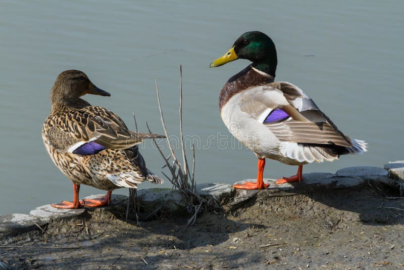
Free with trial Two ducks, male and female, are standing on the shore, at the edge of the water. They are facing the water and with their backs to the camera. Both have their heads turned looking at each other, as if they were making plans to lie down into the water. the photograph has been taken in the Natural Park of the Camargue Region, in Provence. Two were stock images, royalty-free photos and pictures Two ducks, one male and one female, look at each other. Two ducks, male and female, are standing on the shore, at the edge of the water. They are facing the water and with their backs to the camera. Both have their heads turned looking at each other, as if they were making plans to lie down into the water. the photograph has been taken in the Natural Park of the Camargue Region, in Provence.
Free with trial Fisherman boat with two fishers at Bali, Indonesia during sunset at the beach. Golden sunset making the boat, the sand and the water look like it were made of gold. Unique moment captured by the camera. Two were stock images, royalty-free photos and pictures Fisherman boat with two fishers at Bali, Indonesia during sunset at the beach.
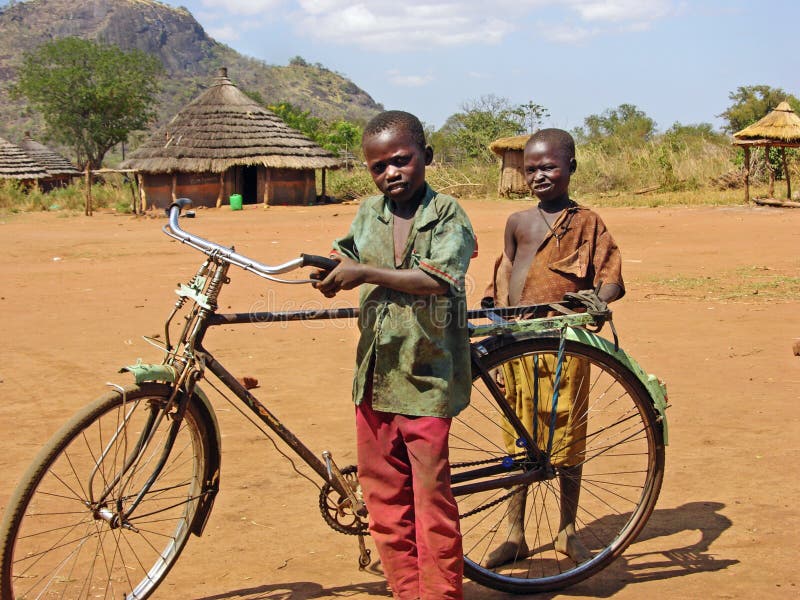
Free with trial This photograph was taken while we were in Uganda, Africa for two months doing aid relief work. We travelled to Karamoja, a remote and forgotten lot of villages that is poverty stricken with much need for food, medical care, clothing, and fresh clean water. These two children, two boys, stopped to allow me to take their photograph with their prize possession an old rusty bicycle , the only one in the village. I was told that they travel on it to find water and bring it back to the village. When we were there it had not rained for 2 years and the river had almost completely dried up from the severe drought and all that was remaining in the empty river bed was a few very small pools of water, that was guarded by the villagers against animals. The village and people were suffering from severe hunger, much need for medical attention, soap, salt, staple food and clean clothing and clean fresh water, basic education and comfort just to name some. It was heartbreaking to witness and although we brought what relief we could, there were just too many poor people and children to be able to help all. This image is for editorial purposes only. Two were stock images, royalty-free photos and pictures Poor African children with old bicycle remote village Africa. This photograph was taken while we were in Uganda, Africa for two months doing aid relief work. We travelled to Karamoja, a remote and forgotten lot of villages that is poverty stricken with much need for food, medical care, clothing, and fresh clean water. These two children, two boys, stopped to allow me to take their photograph with their prize possession an old rusty bicycle , the only one in the village. I was told that they travel on it to find water and bring it back to the village. When we were there it had not rained for 2 years and the river had almost completely dried up from the severe drought and all that was remaining in the empty river bed was a few very small pools of water, that was guarded by the villagers against animals. The village and people were suffering from severe hunger, much need for medical attention, soap, salt, staple food and clean clothing and clean fresh water, basic education and comfort just to name some. It was heartbreaking to witness and although we brought what relief we could, there were just too many poor people and children to be able to help all. This image is for editorial purposes only.
Free with trial Two children kids enjoying the countryside and their future growing up taking in the breathtaking views over England in Summer. This was the first time they saw the world from this height and were just amazed. Two were stock images, royalty-free photos and pictures Children kids enjoying the countryside and their future growing up
Free with trial Two young men were taking wedding photographs in the mist of the tropical rainforest. Two were stock images, royalty-free photos and pictures Wedding photos in the rainforest. Two young men were taking wedding photographs in the mist of the tropical rainforest.
Free with trial Waeller dog and a mongrel tethered to a street lamp wait together for their owners. The Wäller is a newly created breed of dogs in germany Breeding started in 1994. Briard and Australian Shepherd were crossed. Two were stock images, royalty-free photos and pictures Two big dogs, tied to a lamp post, wait for their owners. Waeller dog and a mongrel tethered to a street lamp wait together for their owners. The Wäller is a newly created breed of dogs in germany Breeding started in 1994. Briard and Australian Shepherd were crossed
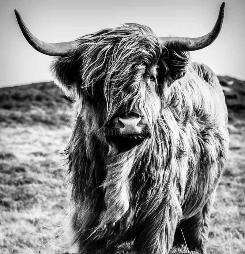
Free with trial The Highland Scottish Gaelic: Bò Ghà idhealach; Scots: Hielan coo is a Scottish breed of rustic cattle. It originated in the Scottish Highlands and the Outer Hebrides islands of Scotland and has long horns and a long shaggy coat. It is a hardy breed, bred to withstand the intemperate conditions in the region. The first herd-book dates from 1885; two types – a smaller island type, usually black, and a larger mainland type, usually dun – were registered as a single breed. It is reared primarily for beef, and has been exported to several other countries. Two were stock images, royalty-free photos and pictures Highland Cow B&W. The Highland Scottish Gaelic: Bò Ghà idhealach; Scots: Hielan coo is a Scottish breed of rustic cattle. It originated in the Scottish. The Highland Scottish Gaelic: Bò Ghà idhealach; Scots: Hielan coo is a Scottish breed of rustic cattle. It originated in the Scottish Highlands and the Outer Hebrides islands of Scotland and has long horns and a long shaggy coat. It is a hardy breed, bred to withstand the intemperate conditions in the region. The first herd-book dates from 1885; two types – a smaller island type, usually black, and a larger mainland type, usually dun – were registered as a single breed. It is reared primarily for beef, and has been exported to several other countries
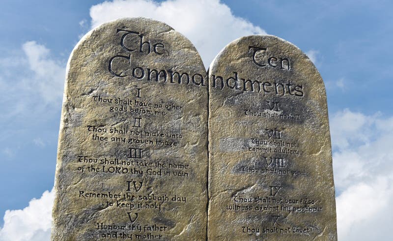
Free with trial The Ten Commandments were written by God upon two tablets of stone and then given to Moses on Mount Sinai. Most scholars date this event around the 13th or 14th century BC. God gave the Decalogue, or 10 Commandments, to the Israelites shortly after they left Egypt. Two were stock images, royalty-free photos and pictures Ten Commandments from the God of Moses and Abraham. The Ten Commandments were written by God upon two tablets of stone and then given to Moses on Mount Sinai. Most scholars date this event around the 13th or 14th century BC. God gave the Decalogue, or 10 Commandments, to the Israelites shortly after they left Egypt.
Free with trial The Bahia Honda Rail Bridge is a scenic bridge in the lower Florida Keys connecting Bahia Honda Key with Spanish Harbor Key. Originally part of the Overseas Railway, the State of Florida purchased it after the 1935 Labor Day Hurricane and converted it to automobile use (as part of the Overseas Highway in 1938. After a replacement Bahia Honda Bridge was opened in 1972, two sections of the Rail Bridge were removed, but the rest remain standing. Two were stock images, royalty-free photos and pictures Bahia Honda Bridge
Free with trial Black and white wingtip leather shoes were very stylish in the 1920s through the 1940s. Two were stock images, royalty-free photos and pictures Mens Retro Black and White Leather Dress Shoes. Black and white wingtip leather shoes were very stylish in the 1920s through the 1940s.
Free with trial The UH 60 Black Hawk United States Army helicopter simulating a beach invasion. The Sikorsky UH-60 Black Hawk is a medium-lift utility or assault helicopter derived from the twin-turboshaft engine, single rotor Sikorsky S-70. The S-70 was the winner of a United States Army Utility Tactical Transport Aircraft System (UTTAS) competition in the early 1970s to replace the UH-1 Huey family. Though the two final competing designs were both developed to Army specifications, the UH-60 was selected over the Boeing-Vertol YUH-61 entry from Boeing-Vertol. It would go on to serve as the basis for variants in service with other branches of the US military. The Black Hawk series of aircraft can perform a wide array of missions, including the tactical transport of troops, electronic warfare, and aeromedical evacuation: several VH-60N Black Hawks are even used to transport the President of the United States as Marine One, known as the VH-60 Whitehawk. [1] In air assault operations it can move a squad of 11 combat troops with equipment or reposition the 105 mm M102 howitzer with thirty rounds of 105 mm ammunition, and a four-man crew in a single lift. Alternatively, it can carry 2, 600 lb (1, 170 kg) of cargo or sling load 9, 000 lb (4, 050 kg) of cargo. The Black Hawk is equipped with advanced avionics and electronics for increased survivability and capability, such as the Global Positioning System. Two were stock images, royalty-free photos and pictures UH 60 Black Hawk Helicopter. The UH 60 Black Hawk United States Army helicopter simulating a beach invasion. The Sikorsky UH-60 Black Hawk is a medium-lift utility or assault helicopter derived from the twin-turboshaft engine, single rotor Sikorsky S-70. The S-70 was the winner of a United States Army Utility Tactical Transport Aircraft System (UTTAS) competition in the early 1970s to replace the UH-1 Huey family. Though the two final competing designs were both developed to Army specifications, the UH-60 was selected over the Boeing-Vertol YUH-61 entry from Boeing-Vertol. It would go on to serve as the basis for variants in service with other branches of the US military. The Black Hawk series of aircraft can perform a wide array of missions, including the tactical transport of troops, electronic warfare, and aeromedical evacuation: several VH-60N Black Hawks are even used to transport the President of the United States as Marine One, known as the VH-60 Whitehawk. [1] In air assault operations it can move a squad of 11 combat troops with equipment or reposition the 105 mm M102 howitzer with thirty rounds of 105 mm ammunition, and a four-man crew in a single lift. Alternatively, it can carry 2, 600 lb (1, 170 kg) of cargo or sling load 9, 000 lb (4, 050 kg) of cargo. The Black Hawk is equipped with advanced avionics and electronics for increased survivability and capability, such as the Global Positioning System.
Free with trial Abu Simbel is an archaeological site comprising two massive rock temples in southern Egypt on the western bank of Lake Nasser about 290 km southwest of Aswan. It is part of the UNESCO World Heritage Site known as the Nubian Monuments, which run from Abu Simbel downriver to Philae (near Aswan). The twin temples were originally carved out of the mountainside during the reign of Pharaoh Ramesses II in the 13th century BC, as a lasting monument to himself and his queen Nefertari, to commemorate his alleged victory at the Battle of Kadesh, and to intimidate his Nubian neighbours. However, the complex was relocated in its entirety in the 1960s, on an artificial hill made from a domed structure, high above the Aswan dam reservoir. The relocation of the temples was necessary to avoid being submerged during the creation of Lake Nasser, the massive artificial water reservoir formed after the building of the Aswan dam on the Nile River. Abu Simbel remains one of Egypt's top tourist attractions. Construction of the temple complex started in approximately 1284 BC and lasted for circa 20 years, until 1264 BC. Known as the Temple of Ramesses, beloved by Amun, it was one of six rock temples erected in Nubia during the long reign of Ramesses. Their purpose was to impress Egypt's southern neighbours, and also to reinforce the status of Egyptian religion in the region. Two were stock images, royalty-free photos and pictures Abu Simbel - Temple of Hathor & Nefertari. Abu Simbel is an archaeological site comprising two massive rock temples in southern Egypt on the western bank of Lake Nasser about 290 km southwest of Aswan. It is part of the UNESCO World Heritage Site known as the Nubian Monuments, which run from Abu Simbel downriver to Philae (near Aswan). The twin temples were originally carved out of the mountainside during the reign of Pharaoh Ramesses II in the 13th century BC, as a lasting monument to himself and his queen Nefertari, to commemorate his alleged victory at the Battle of Kadesh, and to intimidate his Nubian neighbours. However, the complex was relocated in its entirety in the 1960s, on an artificial hill made from a domed structure, high above the Aswan dam reservoir. The relocation of the temples was necessary to avoid being submerged during the creation of Lake Nasser, the massive artificial water reservoir formed after the building of the Aswan dam on the Nile River. Abu Simbel remains one of Egypt's top tourist attractions. Construction of the temple complex started in approximately 1284 BC and lasted for circa 20 years, until 1264 BC. Known as the Temple of Ramesses, beloved by Amun, it was one of six rock temples erected in Nubia during the long reign of Ramesses. Their purpose was to impress Egypt's southern neighbours, and also to reinforce the status of Egyptian religion in the region.
Free with trial Remember when love was just holding hands? Or writing a note that said do you like me circle yes or no? This image is the Garden of youth when times were so innocent, before having to be an adult. Two children in a garden of flowers. They are black and white and the flowers are hand tinted in color. Two were stock images, royalty-free photos and pictures Young Love. Remember when love was just holding hands? Or writing a note that said do you like me circle yes or no? This image is the Garden of youth when times were so innocent, before having to be an adult. Two children in a garden of flowers. They are black and white and the flowers are hand tinted in color.
Free with trial This cub was one of four cubs in the Western North Carolina Mountains. The other three cubs were out running up a tree but this little fellow stayed under Mom. Two were stock images, royalty-free photos and pictures Standing under Mom. This cub was one of four cubs in the Western North Carolina Mountains. The other three cubs were out running up a tree but this little fellow stayed under Mom.
Free with trial Series of four darkroom 35mm film photo borders with rough edges - one with sprocket holes, two with colour edges. Frames were created by filing the metal edges of different negative carriers for my enlarger. Scanned, mutilated and altered in photoshop. Two were stock images, royalty-free photos and pictures Photo edges and frames. Series of four darkroom 35mm film photo borders with rough edges - one with sprocket holes, two with colour edges. Frames were created by filing the metal edges of different negative carriers for my enlarger. Scanned, mutilated and altered in photoshop.
Free with trial On Bloody Sunday, March 7, 1965 600 civil rights activist were met on this bridge by state and local law enforcement who used billy clubs and tear gas to disburse the gathering. Two weeks later lead by Martin Luther King Jr. 3,200 marchers successfully marched from Selma to Montgomery. Less than five months later President Lyndon Johnson signed into law the Voting rights act of 1965. Two were stock images, royalty-free photos and pictures Edmund Pettus Bridge. On Bloody Sunday, March 7, 1965 600 civil rights activist were met on this bridge by state and local law enforcement who used billy clubs and tear gas to disburse the gathering. Two weeks later lead by Martin Luther King Jr. 3,200 marchers successfully marched from Selma to Montgomery. Less than five months later President Lyndon Johnson signed into law the Voting rights act of 1965.
Free with trial A view of a corner between two very old houses in a middleage village in central Italy - Civita di Bagnoregio. The two big vases were used il old times for storing olive oil. Two were stock images, royalty-free photos and pictures Old italian town corner. A view of a corner between two very old houses in a middleage village in central Italy - Civita di Bagnoregio. The two big vases were used il old times for storing olive oil.
Free with trial Male european bison(Aurochs) in the autumn forest. The European bison (Bison bonasus), also known as the European wood bison, is a Eurasian species of bison. It is one of two extant species of bison, alongside the American bison. European bison were hunted to extinction in the wild, with the last wild animals being shot in the Bialowieza Forest (on the Poland-Belarus border) in 1919 and in the North-Western Caucasus in 1927, but have since been reintroduced from captivity into several countries in Europe, also in Romania. They are now forest-dwelling. They have few predators (besides humans), with only scattered reports from the 19th century of wolf and bear predation. European bison were first scientifically described by Carolus Linnaeus in 1758. Some later descriptions treat the European bison as conspecific with the American bison. It is not to be confused with the aurochs, the extinct ancestor of domestic cattle. In over 200 years since the disappearance of the current space Romanian bison, the bison population in Romania has reached nearly 100. In 1958 the species was reintroduced in Romania after two bison were brought from Poland to forest Slivut, near the town Hateg in Hunedoara county. Currently, the heaviest land animal in Europe can be seen in Romania in four reserves or released into the wild. Last two years ago some of the bison are released into the wild and they were the first to be released buffalo forever wild in the forest of Romania. Two were stock images, royalty-free photos and pictures Male european bison, in the autumn forest. Male european bison(Aurochs) in the autumn forest. The European bison (Bison bonasus), also known as the European wood bison, is a Eurasian species of bison. It is one of two extant species of bison, alongside the American bison. European bison were hunted to extinction in the wild, with the last wild animals being shot in the Bialowieza Forest (on the Poland-Belarus border) in 1919 and in the North-Western Caucasus in 1927, but have since been reintroduced from captivity into several countries in Europe, also in Romania. They are now forest-dwelling. They have few predators (besides humans), with only scattered reports from the 19th century of wolf and bear predation. European bison were first scientifically described by Carolus Linnaeus in 1758. Some later descriptions treat the European bison as conspecific with the American bison. It is not to be confused with the aurochs, the extinct ancestor of domestic cattle. In over 200 years since the disappearance of the current space Romanian bison, the bison population in Romania has reached nearly 100. In 1958 the species was reintroduced in Romania after two bison were brought from Poland to forest Slivut, near the town Hateg in Hunedoara county. Currently, the heaviest land animal in Europe can be seen in Romania in four reserves or released into the wild. Last two years ago some of the bison are released into the wild and they were the first to be released buffalo forever wild in the forest of Romania.
Free with trial Mute Swan Mother carrying a cygnet on her back. This shot followed a drama where I put down my camera to rescue two cygnets who got swept away from their parents over a small waterfall and after they were reunited the mother swan was feeling protective and one of the cygnets rode on her back. Two were stock images, royalty-free photos and pictures Baby on Board. Mute Swan Mother carrying a cygnet on her back. This shot followed a drama where I put down my camera to rescue two cygnets who got swept away from their parents over a small waterfall and after they were reunited the mother swan was feeling protective and one of the cygnets rode on her back.
Free with trial Beautiful photograph of two flowers that were part of an Easter bouquet. Grainy shot. Two were stock images, royalty-free photos and pictures Fine Art Black and White Flowers. Beautiful photograph of two flowers that were part of an Easter bouquet. Grainy shot.
Free with trial Maybe the Mayans were right, the world is going to end in an apocalypse, they were just off by a year or two. Shown here is old ancient Mayan ruins being stuck by lightning as life as we know it ends and we go into doomsday. Dark and stormy clouds add to the concept. Two were stock images, royalty-free photos and pictures Mayan Apocalypse, Doomsday End of World. Maybe the Mayans were right, the world is going to end in an apocalypse, they were just off by a year or two. Shown here is old ancient Mayan ruins being stuck by lightning as life as we know it ends and we go into doomsday. Dark and stormy clouds add to the concept.
Free with trial This is one of my favorite images because it shows the sheer joy on the beautiful smiling faces of the young African children in a remote African village we visited on our aid relief volunteer trip for two months in Uganda, Eastern Africa. These children had never seen a camera or had their photo taken before and their cheeky curiosity, playfulness and sweet natures shines through along with their innocence despite their poor and needy circumstances. All of these children were in need of clothing, staple food, soap and medical help, most of which we were able to supply while there. Two were stock images, royalty-free photos and pictures Sweet playful cheeky African children smiling for first photo. This is one of my favorite images because it shows the sheer joy on the beautiful smiling faces of the young African children in a remote African village we visited on our aid relief volunteer trip for two months in Uganda, Eastern Africa. These children had never seen a camera or had their photo taken before and their cheeky curiosity, playfulness and sweet natures shines through along with their innocence despite their poor and needy circumstances. All of these children were in need of clothing, staple food, soap and medical help, most of which we were able to supply while there.
Free with trial The international groups of pilgrims are astonished, paying and taking pictures in the Garden of Gethsemane. The two thousand-years olive trees were witnesses of famous biblical events. Jesus came to this place with his apostles and He was arrested before the crucifixion. This is the panoramic picture. Jerusalem. Israel. The left side of picture can be used for your text. Two were stock images, royalty-free photos and pictures Pilgrims in Gethsemane Garden. Jerusalem. Panorama. The international groups of pilgrims are astonished, paying and taking pictures in the Garden of Gethsemane. The two thousand-years olive trees were witnesses of famous biblical events. Jesus came to this place with his apostles and He was arrested before the crucifixion. This is the panoramic picture. Jerusalem. Israel. The left side of picture can be used for your text.
Free with trial Close up of senior`s hands holding up an old photograph of themselves, when they were young while sitting on their vintage living room couch at home. Two were stock images, royalty-free photos and pictures Hands of senior couple holding their youthful photo at home. Close up of senior`s hands holding up an old photograph of themselves, when they were young while sitting on their vintage living room couch at home
Free with trial Kakku Pagoda offers a unique alternative to the plentiful temples spread throughout Southeast Asia. nWhile most of Kakku’s stupas were built in the 17th and 18th centuries, the largest is believed to have been built in the 12th century during the reign of Alaungsithu, King of Bagan, as part of expanding religious sites across his empire. Since then, two main architectural designs have created a distinct forest of 2,478 needle stick pagodas that reach out to take the shape of Buddha’s footprint. Two were stock images, royalty-free photos and pictures Kakku Pagodas temple complex prayer. Kakku Pagoda offers a unique alternative to the plentiful temples spread throughout Southeast Asia. nWhile most of Kakku’s stupas were built in the 17th and 18th centuries, the largest is believed to have been built in the 12th century during the reign of Alaungsithu, King of Bagan, as part of expanding religious sites across his empire. Since then, two main architectural designs have created a distinct forest of 2,478 needle stick pagodas that reach out to take the shape of Buddha’s footprint.
Free with trial The tonal shading and stacked symmetry of these painted concrete casings were on display at the National Building Museum in Washington D. C. The tubes were several stories high and very impressive. Two were stock images, royalty-free photos and pictures Two tone perspective pattern of cylinders. The tonal shading and stacked symmetry of these painted concrete casings were on display at the National Building Museum in Washington D.C. The tubes were several stories high and very impressive.
Free with trial The Todra gorges in Arabic: مضيق تودغا, Maá¸Ä«q TÅ«dgha are a canyon located in the eastern zone of the High Atlas Mountains in Morocco, near the town of Tinerhir. Both the Todra River and the nearby Dades have excavated, over the millennia, a canyon between the rocks in Arabic wadi in their final course among the mountains. The last 600 meters of gorges are the most spectacular. Here, the two rock walls reach their minimum distance of at least 10 meters, with overcrowded rocks reaching 160 meters high. Todra gorges at the narrowest point. The flow of the small glacier that feeds the river, which once filled its throat, is today very modest and present only in the rainy season. Hiking in the gorge is easy along an asphalted road in good condition, raised above the bed of the creek. The scenery is spectacular. The local population is visible with its small donkeys or camels and scattered goat`s groups. The area is no longer remote as it was once. A well-groomed paved road leads to the valley from Tinerhir through the gorge. A concrete road continues up the valley, beyond the hotel facilities at the mouth of the gorge to the villages of Aït Hani, Tamtatouchte and Imilchil. Thanks to the rugged rock walls, with many irregular surfaces, the Todra Gorges are highly appreciated by mountaineers. More than 150 routes, rated between +5 and 8, were made in the canyon. Two were stock images, royalty-free photos and pictures Woman with her baby in the river of The Todra gorges in Morocco. The Todra gorges in Arabic: مضيق تودغا, Maá¸Ä«q TÅ«dgha are a canyon located in the eastern zone of the High Atlas Mountains in Morocco, near the town of Tinerhir. Both the Todra River and the nearby Dades have excavated, over the millennia, a canyon between the rocks in Arabic wadi in their final course among the mountains. The last 600 meters of gorges are the most spectacular. Here, the two rock walls reach their minimum distance of at least 10 meters, with overcrowded rocks reaching 160 meters high. Todra gorges at the narrowest point. The flow of the small glacier that feeds the river, which once filled its throat, is today very modest and present only in the rainy season. Hiking in the gorge is easy along an asphalted road in good condition, raised above the bed of the creek. The scenery is spectacular. The local population is visible with its small donkeys or camels and scattered goat`s groups. The area is no longer remote as it was once. A well-groomed paved road leads to the valley from Tinerhir through the gorge. A concrete road continues up the valley, beyond the hotel facilities at the mouth of the gorge to the villages of Aït Hani, Tamtatouchte and Imilchil. Thanks to the rugged rock walls, with many irregular surfaces, the Todra Gorges are highly appreciated by mountaineers. More than 150 routes, rated between +5 and 8, were made in the canyon.
Free with trial Tiles for America began on September 12, 2001. In the aftermath of the tragedy, crowds gathered in large numbers in front of Saint Vincent's Hospital, located at the corner of 7th Avenue and 11th Street. This was the hospital that was prepared to receive the thousands of survivors that many people were hopeful they would be. Lorrie Veasey, owner of OUR NAME IS MUD, also located on 11th Street, began to create what she hoped would be an inspiration to recovering victims. From raw clay she fashioned approximately 5000 small angels and American flags, which she and friends attached to a fence that faced the hospital on September 14. The angels and flags were attached with ribbon, and before two weeks had passed, most of them had been removed from the fence. pre-9/11, ceramics started to be hung on this fence sometime in the late 60's or early 70's. After 9/11 these ceramics multiplied. The older, original ceramics can be found on Greenwich Ave. where the fence meets the store in the right of this frame. Two were stock images, royalty-free photos and pictures Tiles for America in NYC - remembering 9/11/2001. Tiles for America began on September 12, 2001. In the aftermath of the tragedy, crowds gathered in large numbers in front of Saint Vincent's Hospital, located at the corner of 7th Avenue and 11th Street. This was the hospital that was prepared to receive the thousands of survivors that many people were hopeful they would be. Lorrie Veasey, owner of OUR NAME IS MUD, also located on 11th Street, began to create what she hoped would be an inspiration to recovering victims. From raw clay she fashioned approximately 5000 small angels and American flags, which she and friends attached to a fence that faced the hospital on September 14. The angels and flags were attached with ribbon, and before two weeks had passed, most of them had been removed from the fence. pre-9/11, ceramics started to be hung on this fence sometime in the late 60's or early 70's. After 9/11 these ceramics multiplied. The older, original ceramics can be found on Greenwich Ave. where the fence meets the store in the right of this frame.
Free with trial The Aztec calendar was the calendar of the Aztec people of Pre-Columbian Mexico. It is one of the Mesoamerican calendars, sharing the basic structure of calendars from throughout ancient Mesoamerica. The calendar consisted of a 365 day calendar cycle and a 260 day ritual cycle. These two cycles together formed a 52 year century, sometimes called the Calendar Round. Every month had its name, and the days of the month were numbered from one to twenty. The days of the last month, Nemontemi, were numbered from one to five. The box at the top of the stone contains the stone's year of creation, in this case 1479 CE. The solar calendar of 365 days was inseparable from the Sacred Round, or Sacred Almanac. The priests used this ritual calendar of 260 days called Tonalpohualli primarily for divinatory purposes. The method of naming the individual days consisted in the combination of twenty pictorial signs with the numbers one to thirteen. Each of the day signs also bears an association with one of the four cardinal directions. The 20 day signs are depicted in the calendar image to the right. They are arrayed in a circle surrounding the central face. Two were stock images, royalty-free photos and pictures Aztec Calendar
Free with trial Old western Elvis Memorial Chapel and historical Apacheland barn at Superstition Mountain Museum located in Apache Junction, Arizona, USA. The barn has been featured in dozens of western films that were shot at this location. Elvis Memorial Chapel serves as a wedding chapel and a movie memorabilia museum showcasing the movies that were filmed at Apacheland. This chapel has survived two different fires, one in 1969 and one in 2004, and later was donated to the museum. Two were stock images, royalty-free photos and pictures Old West Chapel and Apacheland Barn in Apache Junction, AZ. Old western Elvis Memorial Chapel and historical Apacheland barn at Superstition Mountain Museum located in Apache Junction, Arizona, USA. The barn has been featured in dozens of western films that were shot at this location. Elvis Memorial Chapel serves as a wedding chapel and a movie memorabilia museum showcasing the movies that were filmed at Apacheland. This chapel has survived two different fires, one in 1969 and one in 2004, and later was donated to the museum.
Free with trial Two girls supporters kissing in an unusual place for this kind of gesture. The girls were captured in the stand of National Arena during the Romanian Cup Final between Petrolul Ploiesti and CFR Cluj on 1st June 2013. Two were stock images, royalty-free photos and pictures Girls kissing during football match. Two girls supporters kissing in an unusual place for this kind of gesture. The girls were captured in the stand of National Arena during the Romanian Cup Final between Petrolul Ploiesti and CFR Cluj on 1st June 2013.
Free with trial In September 2018, two women in front of a coffee shop in Nanjing, China were painting outdoors. Two were stock images, royalty-free photos and pictures Woman painting in the sunshine on the roadside. In September 2018, two women in front of a coffee shop in Nanjing, China were painting outdoors.
Free with trial Concept: A giant post card reads wish you were here and is on a map which represents vacationing or travel. Two children stand behind the post card. Two were stock images, royalty-free photos and pictures Kids & Post Card - wish you were here. Concept: A giant post card reads wish you were here and is on a map which represents vacationing or travel. Two children stand behind the post card.
Free with trial A unique photograph of two of Africas most loved creatures of its wildlife, the beautiful African elephant and the cheeky hippotomus. This photograph was taken from a small boat we were in on going down the river Nile, Uganda, Africa. Two were stock images, royalty-free photos and pictures Wild elephant & hippo Nile river Uganda Africa. A unique photograph of two of Africas most loved creatures of its wildlife, the beautiful African elephant and the cheeky hippotomus. This photograph was taken from a small boat we were in on going down the river Nile, Uganda, Africa.
Free with trial These two chains remind me of a Bible scripture verse that says, when two or more are gathered in God's name He is there. There is strength in two and a vision of a strong chains come to mind. Also there is a song, the chains that seems to bind you, serve only to remind you, that they lie powerless behind you, when you praise HIM. These two chains were found on the dock by a tugboat. Two were stock images, royalty-free photos and pictures Chains - Double Strength. These two chains remind me of a Bible scripture verse that says, when two or more are gathered in God's name He is there. There is strength in two and a vision of a strong chains come to mind. Also there is a song, the chains that seems to bind you, serve only to remind you, that they lie powerless behind you, when you praise HIM. These two chains were found on the dock by a tugboat.
Free with trial Two youngsters try out the out-fashioned wooden stocks on the Village Green that were once used to punish people for their misdeeds in Colonial Williamsburg, Virginia. Two were stock images, royalty-free photos and pictures Williamsburg, VA: Kids in Stocks. Two youngsters try out the out-fashioned wooden stocks on the Village Green that were once used to punish people for their misdeeds in Colonial Williamsburg, Virginia.
Free with trial The inside of Abu simbel temples. Abu simbel temples are two massive rock temples at Abu Simbel including the Great Temple of Ramesses II on the left, and the Small Temple of Nefertari on the right. They are situated on the western bank of Lake Nasser, about 230 km southwest of Aswan (about 300 km by road). The complex is part of the UNESCO World Heritage Site known as the Nubian Monuments, which run from Abu Simbel downriver to Philae (near Aswan). The twin temples were originally carved out of the mountainside during the reign of Pharaoh Ramesses II in the 13th century BC, as a lasting monument to himself and his queen Nefertari, to commemorate his victory at the Battle of Kadesh. Their huge external rock relief figures have become iconic. Two were stock images, royalty-free photos and pictures Abu Simbel Temples
Free with trial Planets, galaxy, beautiful space landscape. Abstract science fiction. Image in 5K for desktop wallpaper. Elements of the image were furnished by NASA. Two were stock images, royalty-free photos and pictures Planets, galaxy, beautiful space landscape. Abstract science fiction. Elements of the image were furnished by NASA. Planets, galaxy, beautiful space landscape. Abstract science fiction. Image in 5K for desktop wallpaper. Elements of the image were furnished by NASA
Free with trial A pile of damaged boats were pushed to land after the entire dock broke from their pilings. The dock was in Coconut Grove Florida. More damage from the aftermath of the hurricane. Two were stock images, royalty-free photos and pictures Hurricane Irma Damage. A pile of damaged boats were pushed to land after the entire dock broke from their pilings. The dock was in Coconut Grove Florida. More damage from the aftermath of the hurricane.
Free with trial La Sainte-Chapelle (English: The Holy Chapel) is a Gothic chapel on the Île de la Cité in the heart of Paris, France. It is perhaps the high point of the full tide of the rayonnante period of Gothic architecture. It is famous for housing Christian relics including the crown of thorns brought to the site by Louis IX. The Sainte-Chapelle, the palatine chapel in the courtyard of the royal palace on the Île de la Cité, was built to house precious relics: Christ's crown of thorns, the Image of Edessa and thirty other relics of Christ that had been in the possession of Louis IX since August 1239, when it arrived from Venice in the hands of two Dominican friars. Unlike many devout aristocrats, who swiped relics, the saintly Louis bought his precious relics of the Passion, purchased from the Latin emperor at Constantinople, Baldwin II, for the exorbitant sum of 135,000 livres, which was paid to the Venetians, to whom it had been pawned. The entire chapel, by contrast, cost 40,000 livres to build and until it was complete the relics were housed at chapels at the Château de Vincennes and a specially-built chapel at the Château de Saint-Germain-en-Laye. The most visually beautiful aspects of the chapel, and considered the best of their type in the world, are its stained glass for which the stonework is a delicate framework, and rose windows added to the upper chapel in the fifteenth century. Two were stock images, royalty-free photos and pictures Sainte Chapelle Paris. La Sainte-Chapelle (English: The Holy Chapel) is a Gothic chapel on the Île de la Cité in the heart of Paris, France. It is perhaps the high point of the full tide of the rayonnante period of Gothic architecture. It is famous for housing Christian relics including the crown of thorns brought to the site by Louis IX. The Sainte-Chapelle, the palatine chapel in the courtyard of the royal palace on the Île de la Cité, was built to house precious relics: Christ's crown of thorns, the Image of Edessa and thirty other relics of Christ that had been in the possession of Louis IX since August 1239, when it arrived from Venice in the hands of two Dominican friars. Unlike many devout aristocrats, who swiped relics, the saintly Louis bought his precious relics of the Passion, purchased from the Latin emperor at Constantinople, Baldwin II, for the exorbitant sum of 135,000 livres, which was paid to the Venetians, to whom it had been pawned. The entire chapel, by contrast, cost 40,000 livres to build and until it was complete the relics were housed at chapels at the Château de Vincennes and a specially-built chapel at the Château de Saint-Germain-en-Laye. The most visually beautiful aspects of the chapel, and considered the best of their type in the world, are its stained glass for which the stonework is a delicate framework, and rose windows added to the upper chapel in the fifteenth century.
Free with trial The Chicago Harbor Lighthouse is the only surviving lighthouse in Chicago and one of only two remaining examples in Illinois. Built in 1893, the Lighthouse symbolically marks the Chicago Harbor-a historically pivotal point where the nation's maritime transportation network connected the East Coast, the Great Lakes, and ultimately the Gulf Coast. During the 1917 renovation of the breakwater, the lighthouse was moved to its present location, and its attached fog-signal room and boathouse were constructed. The Lighthouse played such a significant role in the development of Chicago that it is commemorated in a relief sculpture, entitled The Spirit of the Waters, located near the LaSalle Street entrance of City Hall. Today its crisp white conical tower rising between two red-roofed buildings is a familiar sight along Chicago's shoreline just east of Navy Pier, where the Lighthouse continues to mark the harbor entrance. Two were stock images, royalty-free photos and pictures Chicago Harbor Lighthouse
Free with trial This is a view of the famous Eagle Tower at Caernarvon Castle in Wales, UK. Caernarvon was defended in two parts - the castle itself, and the town walls. Edward's strongest castles were concentric, providing optimal defensive capabilities, but the use of castle and town walls provided up to two lines of defence, with the benefit of an ostentatious appearance - essential when considering Caernarvon's intended purpose. However, it should not be assumed that Caernarvon was a weak castle - it's completed defences were formidable. The castle itself had two gateways defended by strong gatehouses; it also had seven towers lining it's walls (which themselves were up to twenty feet thick). As mentioned above, the north wall was initially absent, being defended by a ditch and the town itself; the second building phase saw this wall added, completed by the King's Gate. Begun in 1283 after Snowdonia - the heartland of Gwynedd - had been overrun by the massive army, it reached something like its current state in 1323. It was never completed, and even today there are joints visible in several places on the internal walls ready to accept further walls which were never built. Contemporary records note that the castle's construction cost some £22,000 – an enormous sum at the time, equivalent to more than a year's income for the royal treasury. The castle's linear design is sophisticated by comparison with earlier British castles. Two were stock images, royalty-free photos and pictures Eagle Tower study. This is a view of the famous Eagle Tower at Caernarvon Castle in Wales, UK. Caernarvon was defended in two parts - the castle itself, and the town walls. Edward's strongest castles were concentric, providing optimal defensive capabilities, but the use of castle and town walls provided up to two lines of defence, with the benefit of an ostentatious appearance - essential when considering Caernarvon's intended purpose. However, it should not be assumed that Caernarvon was a weak castle - it's completed defences were formidable. The castle itself had two gateways defended by strong gatehouses; it also had seven towers lining it's walls (which themselves were up to twenty feet thick). As mentioned above, the north wall was initially absent, being defended by a ditch and the town itself; the second building phase saw this wall added, completed by the King's Gate. Begun in 1283 after Snowdonia - the heartland of Gwynedd - had been overrun by the massive army, it reached something like its current state in 1323. It was never completed, and even today there are joints visible in several places on the internal walls ready to accept further walls which were never built. Contemporary records note that the castle's construction cost some £22,000 – an enormous sum at the time, equivalent to more than a year's income for the royal treasury. The castle's linear design is sophisticated by comparison with earlier British castles
Free with trial The Castle - Salt and Pepper at Breakaways Coober Pedy, South Australia, popular for opal mining and where segments of Mad Max and Pricilla Queen of the Desert were filmed. Two were stock images, royalty-free photos and pictures The Castle
Free with trial Daguerrotype at the Alinari National Museum of Photography in Florence, Italy. The daguerreotype was the first publicly announced photographic process. The image in a Daguerreotype is formed by the amalgam, or alloy, of mercury and silver. Daguerreotypes were mounted in sealed cases or frames with a glass cover. Two were stock images, royalty-free photos and pictures Daguerreotype
Free with trial A dramatic night shot of the Falkirk Wheel at Night. The Falkirk Wheel is a rotating boat lift connecting the Forth and Clyde Canal with the Union Canal. It is named after the nearby town of Falkirk in central Scotland. The two canals were previously connected by a series of 11 locks, but by the 1930s these had fallen into disuse, were filled in and the land built upon. Two were stock images, royalty-free photos and pictures Falkirk Wheel at Night
Free with trial An army man is telling two small children the importance of brushing their teeth. He sits on a giant toothbrush to make his point. Miniature figures were used for this concept. Two were stock images, royalty-free photos and pictures Brush Your Teeth, kids!. An army man is telling two small children the importance of brushing their teeth. He sits on a giant toothbrush to make his point. Miniature figures were used for this concept.
Free with trial Abu Simbel is an archaeological site comprising two massive rock temples in southern Egypt on the western bank of Lake Nasser about 290 km southwest of Aswan. It is part of the UNESCO World Heritage Site known as the Nubian Monuments, which run from Abu Simbel downriver to Philae (near Aswan). The twin temples were originally carved out of the mountainside during the reign of Pharaoh Ramesses II in the 13th century BC, as a lasting monument to himself and his queen Nefertari, to commemorate his alleged victory at the Battle of Kadesh, and to intimidate his Nubian neighbours. However, the complex was relocated in its entirety in the 1960s, on an artificial hill made from a domed structure, high above the Aswan dam reservoir. The relocation of the temples was necessary to avoid being submerged during the creation of Lake Nasser, the massive artificial water reservoir formed after the building of the Aswan dam on the Nile River. Abu Simbel remains one of Egypt's top tourist attractions. Construction of the temple complex started in approximately 1284 BC and lasted for circa 20 years, until 1264 BC. Known as the Temple of Ramesses, beloved by Amun, it was one of six rock temples erected in Nubia during the long reign of Ramesses. Their purpose was to impress Egypt's southern neighbours, and also to reinforce the status of Egyptian religion in the region. Two were stock images, royalty-free photos and pictures Abu Simbel - Temple of King Ramesses II. Abu Simbel is an archaeological site comprising two massive rock temples in southern Egypt on the western bank of Lake Nasser about 290 km southwest of Aswan. It is part of the UNESCO World Heritage Site known as the Nubian Monuments, which run from Abu Simbel downriver to Philae (near Aswan). The twin temples were originally carved out of the mountainside during the reign of Pharaoh Ramesses II in the 13th century BC, as a lasting monument to himself and his queen Nefertari, to commemorate his alleged victory at the Battle of Kadesh, and to intimidate his Nubian neighbours. However, the complex was relocated in its entirety in the 1960s, on an artificial hill made from a domed structure, high above the Aswan dam reservoir. The relocation of the temples was necessary to avoid being submerged during the creation of Lake Nasser, the massive artificial water reservoir formed after the building of the Aswan dam on the Nile River. Abu Simbel remains one of Egypt's top tourist attractions. Construction of the temple complex started in approximately 1284 BC and lasted for circa 20 years, until 1264 BC. Known as the Temple of Ramesses, beloved by Amun, it was one of six rock temples erected in Nubia during the long reign of Ramesses. Their purpose was to impress Egypt's southern neighbours, and also to reinforce the status of Egyptian religion in the region.
Free with trial A look at the main aisle walkway known as Broadway which divided the two primary general population cell block areas - B-Block and C-Block, that were used to house criminals in famous Alcatraz prison. Two were stock images, royalty-free photos and pictures Alcatraz - Wide View Down Broadway. A look at the main aisle walkway known as Broadway which divided the two primary general population cell block areas - B-Block and C-Block, that were used to house criminals in famous Alcatraz prison.
Free with trial A pair of abandoned Victorian homes that have withstood the test of time. Two weathered beauties that were some of the finer houses of their day. Located in Carthage, Missouri. Two were stock images, royalty-free photos and pictures Pair of Abandoned Victorian Houses. A pair of abandoned Victorian homes that have withstood the test of time. Two weathered beauties that were some of the finer houses of their day. Located in Carthage, Missouri.
Free with trial The sainte-Chapelle in Paris owes its fame to its stained-glass windows: 6,458 sq. ft of glass, of which two thirds are original providing a full sampling of XIIIth century glass work. The lofty and elegant structure of the building seems to fade away, leaving only the windows in all their splendour, as they tell the biblical story of mankind from Creation to his Redemption through Christ. Each window is divided into lancets which must be read from left to right, working from the bottom up. They were admirably restored in the XIXth century. Two were stock images, royalty-free photos and pictures Stained glass in Sainte Chapelle Paris. The sainte-Chapelle in Paris owes its fame to its stained-glass windows: 6,458 sq. ft of glass, of which two thirds are original providing a full sampling of XIIIth century glass work. The lofty and elegant structure of the building seems to fade away, leaving only the windows in all their splendour, as they tell the biblical story of mankind from Creation to his Redemption through Christ. Each window is divided into lancets which must be read from left to right, working from the bottom up. They were admirably restored in the XIXth century.
Free with trial Two sand-cast bronze age heads. The top is a flanged headed axe and the bottom is a socketed axe head. These were used as both tools and weapons for hundreds if not thousands of years. Two were stock images, royalty-free photos and pictures Bronze Age Axe Heads. Two sand-cast bronze age heads. The top is a flanged headed axe and the bottom is a socketed axe head. These were used as both tools and weapons for hundreds if not thousands of years.
Free with trial These are two Clownwoman from a little suburb in Nuremberg. They make a lovely show for shildren on events show their talent although in the city. They were alway dancing and joking so itwas very difficult to get them in front of the camera for the facial;-) You can see more of them at www. rotenase-clowntheater. de. Two were stock images, royalty-free photos and pictures Clownpair. These are two Clownwoman from a little suburb in Nuremberg. They make a lovely show for shildren on events show their talent although in the city. They were alway dancing and joking so itwas very difficult to get them in front of the camera for the facial;-) You can see more of them at www.rotenase-clowntheater.de
Free with trial This two children have been friends since they were able to walk. Two were stock images, royalty-free photos and pictures Friendship. This two children have been friends since they were able to walk.
Free with trial Traditionally the center of Nashville’s nightlife, Printers Alley was, in its earlier days, a series of posts where men bound for the courthouse hitched their horses. By the turn of the twentieth century it had become the center of Nashville’s printing industry; in its heyday, circa 1915, thirteen publishers and ten printers were located in the area serviced by the alley. Nashville’s two largest newspapers, The Tennessean and the Nashville Banner, had their offices here at one time. Two were stock images, royalty-free photos and pictures Downtown Nashville, TN Printers Alley. Traditionally the center of Nashville’s nightlife, Printers Alley was, in its earlier days, a series of posts where men bound for the courthouse hitched their horses. By the turn of the twentieth century it had become the center of Nashville’s printing industry; in its heyday, circa 1915, thirteen publishers and ten printers were located in the area serviced by the alley. Nashville’s two largest newspapers, The Tennessean and the Nashville Banner, had their offices here at one time.
Free with trial The lunar eclipse as seen from the Wild Horse Wind Reservation in Eastern Washington. These photos were taken over a two hour period. Two were stock images, royalty-free photos and pictures Phases of the Lunar Eclipse. The lunar eclipse as seen from the Wild Horse Wind Reservation in Eastern Washington. These photos were taken over a two hour period.
Free with trial This four cute colorful animals were used for my personal project last year, hundreds of their images and I chose a few to be use here, all of them has different focus point ( I intentionally did it on purpose ) as arranged in this image, focus line based on green one. Four high key portrait combined into one. Two were stock images, royalty-free photos and pictures Chicks are in action. This four cute colorful animals were used for my personal project last year, hundreds of their images and I chose a few to be use here, all of them has different focus point ( I intentionally did it on purpose ) as arranged in this image, focus line based on green one. Four high key portrait combined into one.
Free with trial Panoramic view of the famous and majestic islands of the Phang Nga province of Phuket, Thailand. These islands have been used in many movies including James Bond movie Man with the Golden Gun The area is a popular tourist destination. Two pictures were used to make this panoramic. Two were stock images, royalty-free photos and pictures Famous Islands of Thailand. Panoramic view of the famous and majestic islands of the Phang Nga province of Phuket, Thailand. These islands have been used in many movies including James Bond movie Man with the Golden Gun The area is a popular tourist destination. Two pictures were used to make this panoramic.
Free with trial These are old fashioned water coolers which were used in Egyptian homes before the introduction of refrigerators. Made of pottery and are placed near the window to make use of the breeze. Two were stock images, royalty-free photos and pictures Old Fashioned Water Coolers
Free with trial High key shot from backside when they were sleeping and close each other because the room is very cold. They are real living things, I bought them from pet store and they were already come in colors. I used them for my personal project last year and hopefully can be useful here. See also another pose of their action. Very cute. Two were stock images, royalty-free photos and pictures Chicks in secret discussion. High key shot from backside when they were sleeping and close each other because the room is very cold. They are real living things, I bought them from pet store and they were already come in colors. I used them for my personal project last year and hopefully can be useful here. See also another pose of their action. Very cute.
Free with trial This wooden statue of Quan Âm Nghìn Mắt Nghìn Tay (Quan Am with 1000 eyes and 1000 hands) was fashioned in 1656 in Bắc Ninh Province, northern Vietnam. It is now located in the History Museum in Hanoi. One Buddhist legend from the Complete Tale of Guanyin and the Southern Seas (Chinese: å—海觀音全撰; pinyin: NánhÇŽi GuÄnyÄ«n Quánzhuà n) presents Guanyin as vowing to never rest until she had freed all sentient beings from saṃsÄra or cycle of rebirth. [16] Despite strenuous effort, she realised that there were still many unhappy beings yet to be saved. After struggling to comprehend the needs of so many, her head split into eleven pieces. The buddha AmitÄbha, upon seeing her plight, gave her eleven heads to help her hear the cries of those who are suffering. Upon hearing these cries and comprehending them, AvalokiteÅ›vara attempted to reach out to all those who needed aid, but found that her two arms shattered into pieces. Once more, AmitÄbha came to her aid and appointed her a thousand arms to let her reach out to those in need. (Wikepedia). Two were stock images, royalty-free photos and pictures GUANYIN AND THE THOUSAND ARMS AT THE HISTORY MUSEUM IN HANOI, VIETNAM. This wooden statue of Quan Âm Nghìn Mắt Nghìn Tay (Quan Am with 1000 eyes and 1000 hands) was fashioned in 1656 in Bắc Ninh Province, northern Vietnam. It is now located in the History Museum in Hanoi. One Buddhist legend from the Complete Tale of Guanyin and the Southern Seas (Chinese: å—海觀音全撰; pinyin: NánhÇŽi GuÄnyÄ«n Quánzhuà n) presents Guanyin as vowing to never rest until she had freed all sentient beings from saṃsÄra or cycle of rebirth.[16] Despite strenuous effort, she realised that there were still many unhappy beings yet to be saved. After struggling to comprehend the needs of so many, her head split into eleven pieces. The buddha AmitÄbha, upon seeing her plight, gave her eleven heads to help her hear the cries of those who are suffering. Upon hearing these cries and comprehending them, AvalokiteÅ›vara attempted to reach out to all those who needed aid, but found that her two arms shattered into pieces. Once more, AmitÄbha came to her aid and appointed her a thousand arms to let her reach out to those in need. (Wikepedia)
Free with trial Abu Simbel is an archaeological site comprising two massive rock temples in southern Egypt on the western bank of Lake Nasser about 290 km southwest of Aswan. It is part of the UNESCO World Heritage Site known as the Nubian Monuments, which run from Abu Simbel downriver to Philae (near Aswan). The twin temples were originally carved out of the mountainside during the reign of Pharaoh Ramesses II in the 13th century BC, as a lasting monument to himself and his queen Nefertari, to commemorate his alleged victory at the Battle of Kadesh, and to intimidate his Nubian neighbours. However, the complex was relocated in its entirety in the 1960s, on an artificial hill made from a domed structure, high above the Aswan dam reservoir. The relocation of the temples was necessary to avoid being submerged during the creation of Lake Nasser, the massive artificial water reservoir formed after the building of the Aswan dam on the Nile River. Abu Simbel remains one of Egypt's top tourist attractions. Construction of the temple complex started in approximately 1284 BC and lasted for circa 20 years, until 1264 BC. Known as the Temple of Ramesses, beloved by Amun, it was one of six rock temples erected in Nubia during the long reign of Ramesses. Their purpose was to impress Egypt's southern neighbours, and also to reinforce the status of Egyptian religion in the region. With the passing of time, the temples became covered by sand. Already in the 6th century BC, the sand covered the statues of the main temple up to their knees. The temple was forgotten until 1813, when Swiss orientalist JL Burckhardt found the top frieze of the main temple. Burckhardt talked about his discovery with Italian explorer Giovanni Belzoni, who travelled to the site, but was unable to dig out an entry to the temple. Belzoni returned in 1817, this time succeeding in his attempt to enter the complex. The temple was relocated in 1968. Two were stock images, royalty-free photos and pictures Abu Simbel Smaller Queen's Temple (Temple of Hathor & Nefertari) [Near Lake Nasser, Egypt, Arab States, Africa]. Abu Simbel is an archaeological site comprising two massive rock temples in southern Egypt on the western bank of Lake Nasser about 290 km southwest of Aswan. It is part of the UNESCO World Heritage Site known as the Nubian Monuments, which run from Abu Simbel downriver to Philae (near Aswan). The twin temples were originally carved out of the mountainside during the reign of Pharaoh Ramesses II in the 13th century BC, as a lasting monument to himself and his queen Nefertari, to commemorate his alleged victory at the Battle of Kadesh, and to intimidate his Nubian neighbours. However, the complex was relocated in its entirety in the 1960s, on an artificial hill made from a domed structure, high above the Aswan dam reservoir. The relocation of the temples was necessary to avoid being submerged during the creation of Lake Nasser, the massive artificial water reservoir formed after the building of the Aswan dam on the Nile River. Abu Simbel remains one of Egypt's top tourist attractions. Construction of the temple complex started in approximately 1284 BC and lasted for circa 20 years, until 1264 BC. Known as the Temple of Ramesses, beloved by Amun, it was one of six rock temples erected in Nubia during the long reign of Ramesses. Their purpose was to impress Egypt's southern neighbours, and also to reinforce the status of Egyptian religion in the region. With the passing of time, the temples became covered by sand. Already in the 6th century BC, the sand covered the statues of the main temple up to their knees. The temple was forgotten until 1813, when Swiss orientalist JL Burckhardt found the top frieze of the main temple. Burckhardt talked about his discovery with Italian explorer Giovanni Belzoni, who travelled to the site, but was unable to dig out an entry to the temple. Belzoni returned in 1817, this time succeeding in his attempt to enter the complex. The temple was relocated in 1968.
Free with trial An outdoor Santa Fe, New Mexico market featured these beautiful ceramic clay pots and vases. They were all handmade and hand painted. The painted pictures and designs on the pottery were very detailed and intricate. There were no two alike. Two were stock images, royalty-free photos and pictures BRIGHTLY COLORED SOUTHWESTERN CERAMIC CLAY POTTERY. An outdoor Santa Fe, New Mexico market featured these beautiful ceramic clay pots and vases. They were all handmade and hand painted. The painted pictures and designs on the pottery were very detailed and intricate. There were no two alike.
Free with trial Poulnabrone dolmen, a portal tomb in The Burren, County Clare in Ireland. This dates back to the Neolithic period, probably between 4200 BC and 2900 BC. Two were stock images, royalty-free photos and pictures Poulnabrone dolmen, a portal tomb in The Burren in Ireland. Poulnabrone dolmen, a portal tomb in The Burren, County Clare in Ireland. This dates back to the Neolithic period, probably between 4200 BC and 2900 BC.
Free with trial Critical situation in the operating room - working two surgeons, were infused drugs. Two were stock images, royalty-free photos and pictures Critical situation in the operating room
Free with trial Male european bison(Aurochs) in the autumn forest. The European bison (Bison bonasus), also known as the European wood bison, is a Eurasian species of bison. It is one of two extant species of bison, alongside the American bison. European bison were hunted to extinction in the wild, with the last wild animals being shot in the Bialowieza Forest (on the Poland-Belarus border) in 1919 and in the North-Western Caucasus in 1927, but have since been reintroduced from captivity into several countries in Europe, also in Romania. They are now forest-dwelling. They have few predators (besides humans), with only scattered reports from the 19th century of wolf and bear predation. European bison were first scientifically described by Carolus Linnaeus in 1758. Some later descriptions treat the European bison as conspecific with the American bison. It is not to be confused with the aurochs, the extinct ancestor of domestic cattle. In over 200 years since the disappearance of the current space Romanian bison, the bison population in Romania has reached nearly 100. In 1958 the species was reintroduced in Romania after two bison were brought from Poland to forest Slivut,near the town Hateg in Hunedoara county. Currently, the heaviest land animal in Europe can be seen in Romania in four reserves or released into the wild. Last two years ago some of the bison are released into the wild and they were the first to be released buffalo forever wild in the forest of Romania. Two were stock images, royalty-free photos and pictures Big male of european bison stands in the autumn forest. Male european bison(Aurochs) in the autumn forest. The European bison (Bison bonasus), also known as the European wood bison, is a Eurasian species of bison. It is one of two extant species of bison, alongside the American bison. European bison were hunted to extinction in the wild, with the last wild animals being shot in the Bialowieza Forest (on the Poland-Belarus border) in 1919 and in the North-Western Caucasus in 1927, but have since been reintroduced from captivity into several countries in Europe, also in Romania. They are now forest-dwelling. They have few predators (besides humans), with only scattered reports from the 19th century of wolf and bear predation. European bison were first scientifically described by Carolus Linnaeus in 1758. Some later descriptions treat the European bison as conspecific with the American bison.It is not to be confused with the aurochs, the extinct ancestor of domestic cattle. In over 200 years since the disappearance of the current space Romanian bison, the bison population in Romania has reached nearly 100. In 1958 the species was reintroduced in Romania after two bison were brought from Poland to forest Slivut,near the town Hateg in Hunedoara county. Currently, the heaviest land animal in Europe can be seen in Romania in four reserves or released into the wild.Last two years ago some of the bison are released into the wild and they were the first to be released buffalo forever wild in the forest of Romania.
Free with trial These two polar bears were in mating mode. Two were stock images, royalty-free photos and pictures How long ii this going to take. These two polar bears were in mating mode
Free with trial Patient refused of any operation and chemotherapy as a result of this after two years were severe spreading of metastasis to spine vertebrae pelvis and ribs. Two were stock images, royalty-free photos and pictures Cancer metastasis. Patient refused of any operation and chemotherapy as a result of this after two years were severe spreading of metastasis to spine vertebrae pelvis and ribs
Free with trial US Army boots, with desert camouflage, that were used in Afghanistan. Two were stock images, royalty-free photos and pictures US Army boots
Free with trial Education in Zambia is provided at two levels: basic education (years 1 to 9), and upper secondary (years 10 to 12). Some schools provide a basic education covering years 1 to 9, as year 9 is considered to be a decent level of education for the majority of children. However, tuition is only free up to year 7, and UNESCO estimated that 80% of children of primary school age in 2002 were enrolled. Most children drop out after year 7 when fees must be paid. Two were stock images, royalty-free photos and pictures Zambia education. Education in Zambia is provided at two levels: basic education (years 1 to 9), and upper secondary (years 10 to 12). Some schools provide a basic education covering years 1 to 9, as year 9 is considered to be a decent level of education for the majority of children. However, tuition is only free up to year 7, and UNESCO estimated that 80% of children of primary school age in 2002 were enrolled. Most children drop out after year 7 when fees must be paid.
Free with trial A cowboy couple is silhouetted in the sunset as if he were proposing. Two were stock images, royalty-free photos and pictures Cowboy couple silhouette him kneel. A cowboy couple is silhouetted in the sunset as if he were proposing.
Free with trial The entrance to Fingals Cave. Staffa Inland, Inner Hebrides,Argii and Bute Scotland, UK Staffa (Scottish Gaelic: Stafa, pronounced [ˈs̪t̪afa], from the Old Norse for stave or pillar island) is an island of the Inner Hebrides in Argyll and Bute, Scotland. The Vikings gave it this name as its columnar basalt reminded them of their houses, which were built from vertically placed tree-logs. Staffa lies about 10 kilometres (6 mi) west of the Isle of Mull. The area is 33 hectares (82 acres) and the highest point is 42 metres (138 ft) above sea level. The island came to prominence in the late 18th century after a visit by Sir Joseph Banks. He and his fellow-travellers extolled the natural beauty of the basalt columns in general and of the island's main sea cavern, which Banks re-named 'Fingal's Cave'. Their visit was followed by those of many other prominent personalities throughout the next two centuries, including Queen Victoria and Felix Mendelssohn. The latter's Hebrides Overture brought further fame to the island, which was by then uninhabited. It is now in the care of the National Trust for Scotland. Staffa lies about 10 kilometres (6 mi) west of Mull and 9 km northeast of Iona. It is longitudinally oriented north-south and is a kilometre long by about half a kilometre wide. The circumference is about 3. 8 km in extent. In the northeast the isle shelves to a shore, but otherwise the coast is rugged. Two were stock images, royalty-free photos and pictures The entrance to Fingals Cave.Staffa Island,Inner Hebrides,Argyll-Bute, Scotland,UK. The entrance to Fingals Cave. Staffa Inland, Inner Hebrides,Argii and Bute Scotland, UK Staffa (Scottish Gaelic: Stafa, pronounced [ˈs̪t̪afa], from the Old Norse for stave or pillar island) is an island of the Inner Hebrides in Argyll and Bute, Scotland. The Vikings gave it this name as its columnar basalt reminded them of their houses, which were built from vertically placed tree-logs. Staffa lies about 10 kilometres (6 mi) west of the Isle of Mull. The area is 33 hectares (82 acres) and the highest point is 42 metres (138 ft) above sea level. The island came to prominence in the late 18th century after a visit by Sir Joseph Banks. He and his fellow-travellers extolled the natural beauty of the basalt columns in general and of the island's main sea cavern, which Banks re-named 'Fingal's Cave'. Their visit was followed by those of many other prominent personalities throughout the next two centuries, including Queen Victoria and Felix Mendelssohn. The latter's Hebrides Overture brought further fame to the island, which was by then uninhabited. It is now in the care of the National Trust for Scotland. Staffa lies about 10 kilometres (6 mi) west of Mull and 9 km northeast of Iona. It is longitudinally oriented north-south and is a kilometre long by about half a kilometre wide. The circumference is about 3.8 km in extent. In the northeast the isle shelves to a shore, but otherwise the coast is rugged
Free with trial Traditional fisherman lake Kivu boat at the Gisenyi town, Rwanda. Lake Kivu is one of the African Great Lakes. It lies on the border between the Democratic Republic of the Congo and Rwanda. The lake, near Bukavu, Democratic Republic of the CongoThe lake covers a total surface area of some 2,700 km2 and stands at a height of 1,460 metres above sea level. Native fish include species of Barbus, Clarias, and Haplochromis, as well as Nile Tilapia. Limnothrissa miodon, one of two species known as the Tanganyika sardine, was introduced in 1959 and formed the basis of a new pelagic zone fishery. In the early 1990s, the number of fishers on the lake was 6,563, of which 3,027 were associated with the pelagic fishery and 3,536 with the traditional fishery. Widespread armed conflict in the surrounding region from the mid-1990s resulted in a decline in the fisheries harvest. Two were stock images, royalty-free photos and pictures Traditional fisherman lake Kivu boat at Gisenyi. Traditional fisherman lake Kivu boat at the Gisenyi town, Rwanda. Lake Kivu is one of the African Great Lakes. It lies on the border between the Democratic Republic of the Congo and Rwanda. The lake, near Bukavu, Democratic Republic of the CongoThe lake covers a total surface area of some 2,700 km2 and stands at a height of 1,460 metres above sea level. Native fish include species of Barbus, Clarias, and Haplochromis, as well as Nile Tilapia. Limnothrissa miodon, one of two species known as the Tanganyika sardine, was introduced in 1959 and formed the basis of a new pelagic zone fishery. In the early 1990s, the number of fishers on the lake was 6,563, of which 3,027 were associated with the pelagic fishery and 3,536 with the traditional fishery. Widespread armed conflict in the surrounding region from the mid-1990s resulted in a decline in the fisheries harvest.
Free with trial The novice two were water play in the creek. Little monks of Buddhism. Two were stock images, royalty-free photos and pictures Faith of buddhism. The novice two were water play in the creek. Little monks of Buddhism.
Free with trial Dog and cat were running free side-by-side in wind on vast prairie. Two were stock images, royalty-free photos and pictures DOG AND CAT RUNNING ON MEADOW. Dog and cat were running free side-by-side in wind on vast prairie.
Free with trial Wild goat were playing under the sun over the rocks of Crete. Two were stock images, royalty-free photos and pictures Wild goat couple. Wild goat were playing under the sun over the rocks of Crete
Free with trial Children playing at the beach in Bali, Indonesia during a golden sunset. Ocean like gold. The sand and the water look like they were made of gold. Unique moment captured by the camera. Two were stock images, royalty-free photos and pictures Children playing at the beach in Bali, Indonesia during a golden sunset. Ocean like gold.
Free with trial The actual Basilica of St. Anthony is the result of three different reconstructions, which took place over a period of about 70 years: 1238-1310. In St. Anthony's time there was the little church Santa Maria Mater Domini, which was then integrated into the Basilica and is now the Chapel of the Black Madonna. Next to this, in 1229, the Friary sprang up, which was probably founded by St. Anthony himself. St. Anthony died in 1231 in Arcella, in the north of the city where a Clarisse monastery then stood, his body - according his own wishes - was transported and buried in the little church Santa Maria Mater Domini. The construction of the first nucleus of the Basilica, a Franciscan church with only a single nave and a short transept, began in 1238; two lateral naves were added and it was eventually transformed into the amazing structure that we admire today. Two were stock images, royalty-free photos and pictures Basilica of St. Anthony


![The UH 60 Black Hawk United States Army helicopter simulating a beach invasion. The Sikorsky UH-60 Black Hawk is a medium-lift utility or assault helicopter derived from the twin-turboshaft engine, single rotor Sikorsky S-70. The S-70 was the winner of a United States Army Utility Tactical Transport Aircraft System (UTTAS) competition in the early 1970s to replace the UH-1 Huey family. Though the two final competing designs were both developed to Army specifications, the UH-60 was selected over the Boeing-Vertol YUH-61 entry from Boeing-Vertol. It would go on to serve as the basis for variants in service with other branches of the US military. The Black Hawk series of aircraft can perform a wide array of missions, including the tactical transport of troops, electronic warfare, and aeromedical evacuation: several VH-60N Black Hawks are even used to transport the President of the United States as Marine One, known as the VH-60 Whitehawk. [1] In air assault operations it can move a squad of 11 combat troops with equipment or reposition the 105 mm M102 howitzer with thirty rounds of 105 mm ammunition, and a four-man crew in a single lift. Alternatively, it can carry 2, 600 lb (1, 170 kg) of cargo or sling load 9, 000 lb (4, 050 kg) of cargo. The Black Hawk is equipped with advanced avionics and electronics for increased survivability and capability, such as the Global Positioning System. Two were stock images, royalty-free photos and pictures](https://thumbs.dreamstime.com/b/uh-60-black-hawk-helicopter-2427960.jpg)
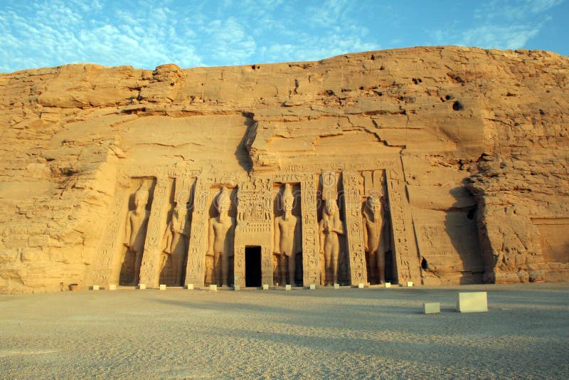


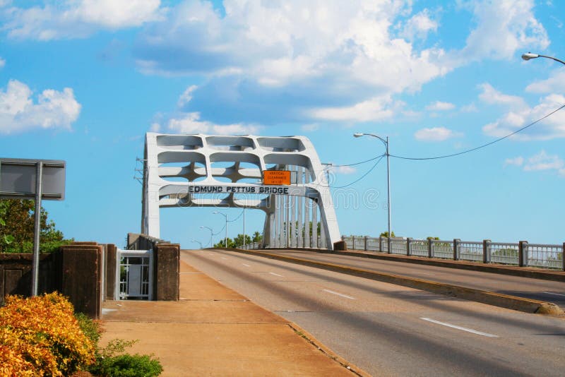
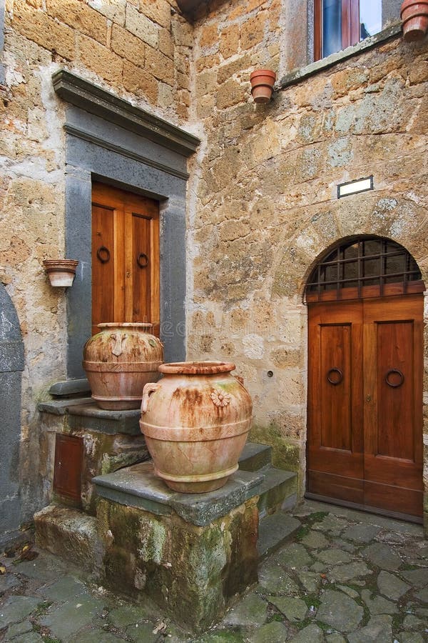
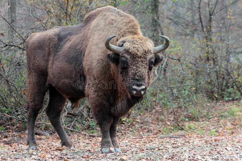


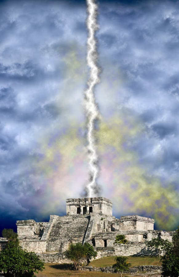


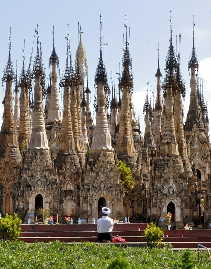


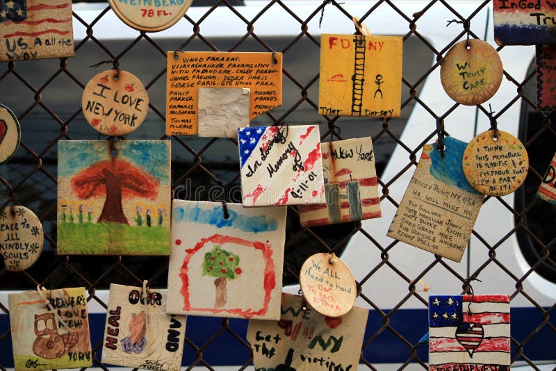


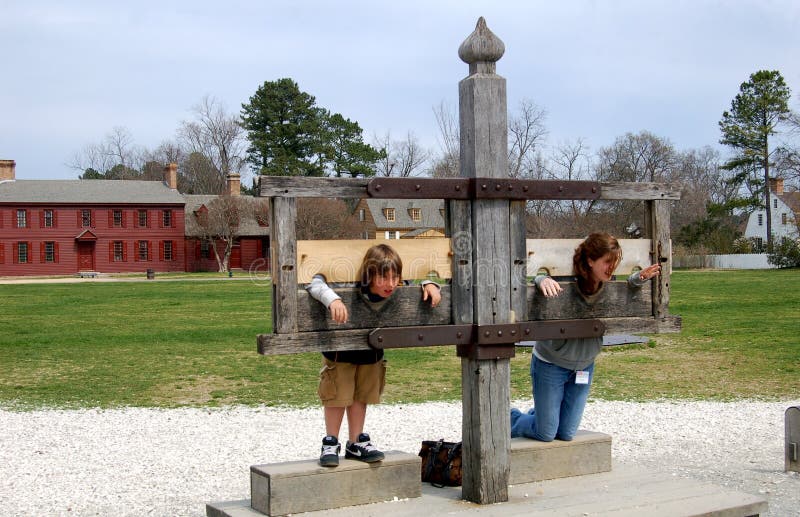
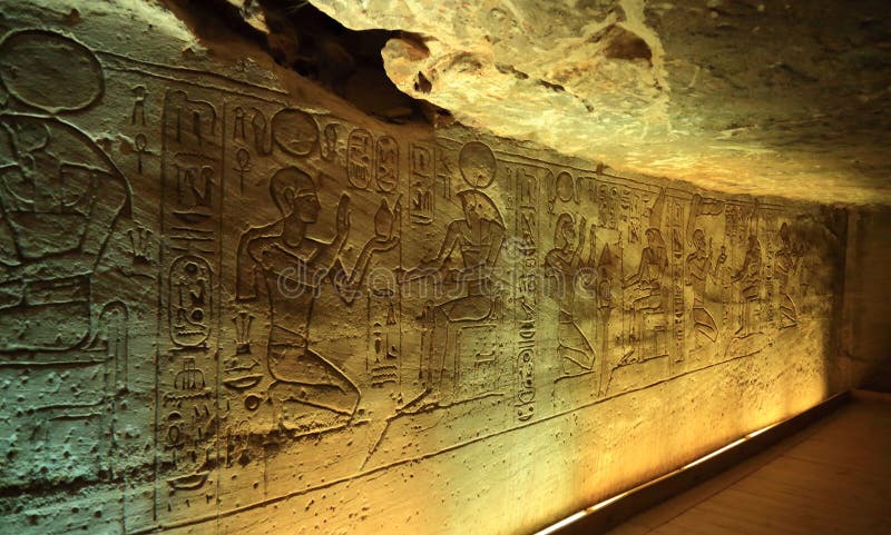


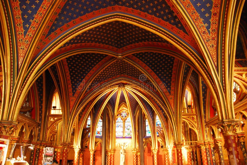


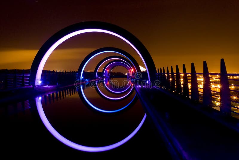

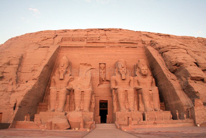

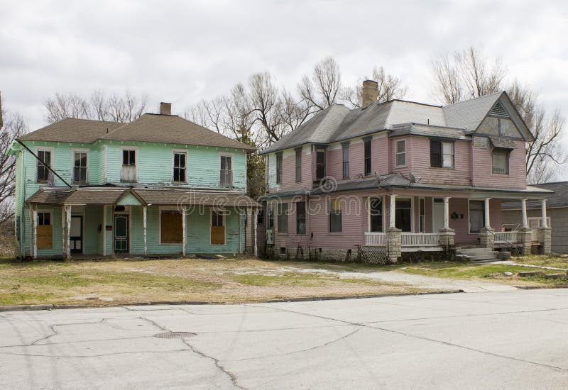
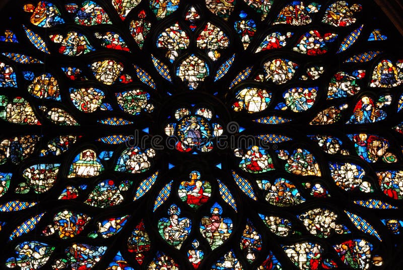
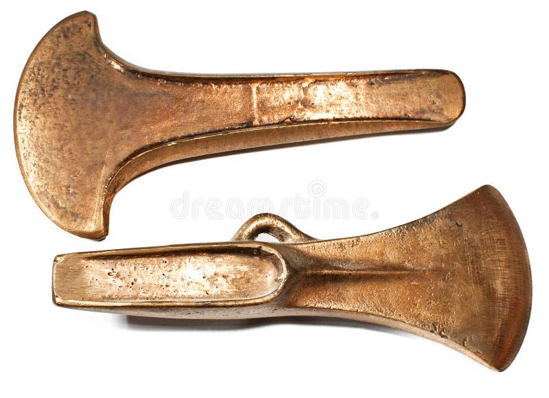


![This wooden statue of Quan Âm Nghìn Mắt Nghìn Tay (Quan Am with 1000 eyes and 1000 hands) was fashioned in 1656 in Bắc Ninh Province, northern Vietnam. It is now located in the History Museum in Hanoi. One Buddhist legend from the Complete Tale of Guanyin and the Southern Seas (Chinese: å—海觀音全撰; pinyin: NánhÇŽi GuÄnyÄ«n Quánzhuà n) presents Guanyin as vowing to never rest until she had freed all sentient beings from saṃsÄra or cycle of rebirth. [16] Despite strenuous effort, she realised that there were still many unhappy beings yet to be saved. After struggling to comprehend the needs of so many, her head split into eleven pieces. The buddha AmitÄbha, upon seeing her plight, gave her eleven heads to help her hear the cries of those who are suffering. Upon hearing these cries and comprehending them, AvalokiteÅ›vara attempted to reach out to all those who needed aid, but found that her two arms shattered into pieces. Once more, AmitÄbha came to her aid and appointed her a thousand arms to let her reach out to those in need. (Wikepedia). Two were stock images, royalty-free photos and pictures](https://thumbs.dreamstime.com/b/guanyin-thousand-arms-history-museum-hanoi-vietnam-wooden-statue-quan-âm-nghìn-mt-nghìn-tay-quan-67237530.jpg)


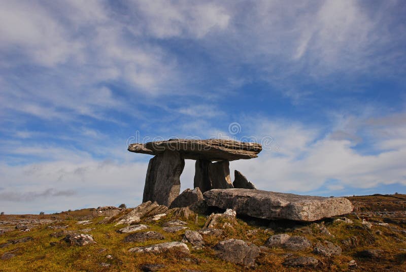

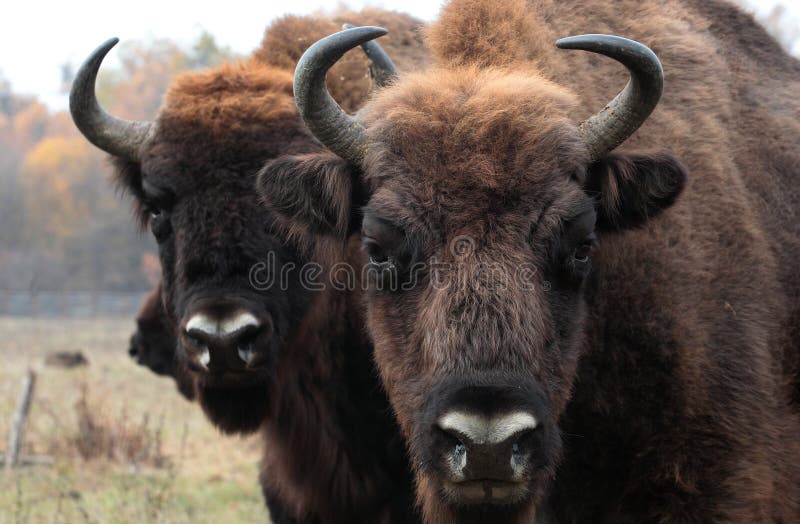


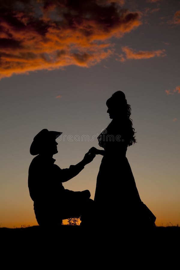
![The entrance to Fingals Cave. Staffa Inland, Inner Hebrides,Argii and Bute Scotland, UK Staffa (Scottish Gaelic: Stafa, pronounced [ˈs̪t̪afa], from the Old Norse for stave or pillar island) is an island of the Inner Hebrides in Argyll and Bute, Scotland. The Vikings gave it this name as its columnar basalt reminded them of their houses, which were built from vertically placed tree-logs. Staffa lies about 10 kilometres (6 mi) west of the Isle of Mull. The area is 33 hectares (82 acres) and the highest point is 42 metres (138 ft) above sea level. The island came to prominence in the late 18th century after a visit by Sir Joseph Banks. He and his fellow-travellers extolled the natural beauty of the basalt columns in general and of the island's main sea cavern, which Banks re-named 'Fingal's Cave'. Their visit was followed by those of many other prominent personalities throughout the next two centuries, including Queen Victoria and Felix Mendelssohn. The latter's Hebrides Overture brought further fame to the island, which was by then uninhabited. It is now in the care of the National Trust for Scotland. Staffa lies about 10 kilometres (6 mi) west of Mull and 9 km northeast of Iona. It is longitudinally oriented north-south and is a kilometre long by about half a kilometre wide. The circumference is about 3. 8 km in extent. In the northeast the isle shelves to a shore, but otherwise the coast is rugged. Two were stock images, royalty-free photos and pictures](https://thumbs.dreamstime.com/b/entrance-to-fingals-cave-staffa-inland-inner-hebrides-scotland-uk-32109192.jpg)


