Free with trial Political map of the Caribbean - Large and Lesser Antilles - with their capitals, national borders, rivers and lakes. Vector illustration with english labeling and scale. Bridgetown vectors Large And Lesser Antilles Political Map. Political map of the Caribbean - Large and Lesser Antilles - with their capitals, national borders, rivers and lakes. Political map of the Caribbean - Large and Lesser Antilles - with their capitals, national borders, rivers and lakes. Vector illustration with english labeling and scale.
Free with trial Political map of Lesser Antilles, Haiti and Dominican Republic with the capitals, national borders, rivers and lakes. Vector illustration with english labeling and scale. Bridgetown vectors Lesser Antilles, Haiti, Dominican Republic. Political map of Lesser Antilles, Haiti and Dominican Republic with the capitals, national borders, rivers and lakes. Political map of Lesser Antilles, Haiti and Dominican Republic with the capitals, national borders, rivers and lakes. Vector illustration with english labeling and scale.
Free with trial A collection of stylised vector South American and Caribbean passport stamps on a white background. Bridgetown vectors Caribbean and South American Passport Stamps. A collection of stylised vector South American and Caribbean passport stamps on a white background. A collection of stylised vector South American and Caribbean passport stamps on a white background.
Free with trial Barbados Political Map with capital Bridgetown, with important cities, places and rivers. English labeling and scaling. Illustration. Bridgetown vectors Barbados Political Map. With capital Bridgetown, with important cities, places and rivers. English labeling and scaling. Illustration
Free with trial Barbados cities and travel destinations. Retro souvenirs collection on old damaged background with places to visit on Barbados. Vacation theme. Bridgetown vectors Barbados cities and travel destinations. Retro souvenirs collection on old damaged background with places to visit on Barbados. Vacation theme
Free with trial A Barbados Map Silhouette Postal Passport Stamp Round Vector Icon Design Travel. Bridgetown vectors Barbados Map Silhouette Postal Passport Stamp Round Vector Icon Design Travel. A Barbados Map Silhouette Postal Passport Stamp Round Vector Icon Design Travel. A Barbados Map Silhouette Postal Passport Stamp Round Vector Icon Design Travel.
Free with trial Caribbean Waving Flag Set. The set includes the flags of Cuba, Jamaica, The Bahamas, Puerto Rico, Haiti, Dominican Republic, Barbados, British Virgin Islands n Dominica. Vector Icons neatly on Layers. Bridgetown vectors Caribbean Waving Flag Set. The set includes the flags of Cuba, Jamaica, The Bahamas, Puerto Rico, Haiti, Dominican Republic, Barbados, British Virgin Islands n
Free with trial Flag of barbado. S vector illustrations. Bridgetown vectors Flag of barbado. S vector illustrations
Free with trial World capitals. Famous Places of American cities. Bridgetown vectors World capitals. Famous Places of American cities
Free with trial Illustration of a detailed political maps of Barbados and Martinique, with their main cities, mountains and rivers. Bridgetown vectors Martinique & Barbados map. Illustration of a detailed political maps of Barbados and Martinique, with their main cities, mountains and rivers. Illustration of a detailed political maps of Barbados and Martinique, with their main cities, mountains and rivers.
Free with trial Barbados, Sint Marteen, Curacao and Aruba travel stamps - Caribbean cruise ship destination badge. Bridgetown vectors Caribbean cruise. Barbados, Sint Marteen, Curacao and Aruba travel stamps - Caribbean cruise ship destination badge. Barbados, Sint Marteen, Curacao and Aruba travel stamps - Caribbean cruise ship destination badge.
Free with trial Caribbean. Passport stamp of the Windward Islands of the Caribbean in vector format. Bridgetown vectors Caribbean. Passport stamp of the Windward Islands of the Caribbean in vector format
Free with trial Barbados road sign set isolated on white background. Bridgetown vectors Barbados road sign set isolated on white background. Barbados road sign set isolated on white background
Free with trial Vector map of barbados. Black vector map of barbados. Bridgetown vectors Vector map of barbados. Black vector map of barbados
Free with trial A vector of the Barbados flag. Bridgetown vectors Barbados Flag. A vector of the Barbados flag. A vector of the Barbados flag.
Free with trial Map of Barbados with hand drawn sketch pen map inside. Vector illustration. Vector sketch map of Barbados with flag, hand drawn chalk illustration. Grunge design. Bridgetown vectors Map of Barbados with hand drawn sketch pen map inside. Vector illustration. Vector sketch map of Barbados with flag, hand drawn chalk illustration. Grunge design
Free with trial Bridgetown, Barbados. Bridgetown, capital and largest city of the nation of Barbados. Bridgetown vectors Bridgetown, Barbados. Bridgetown, capital and largest city of the nation of Barbados
Free with trial Bridgetown, Barbados city silhouette. Skyline. Bridgetown vectors Bridgetown, Barbados city silhouette. Skyline
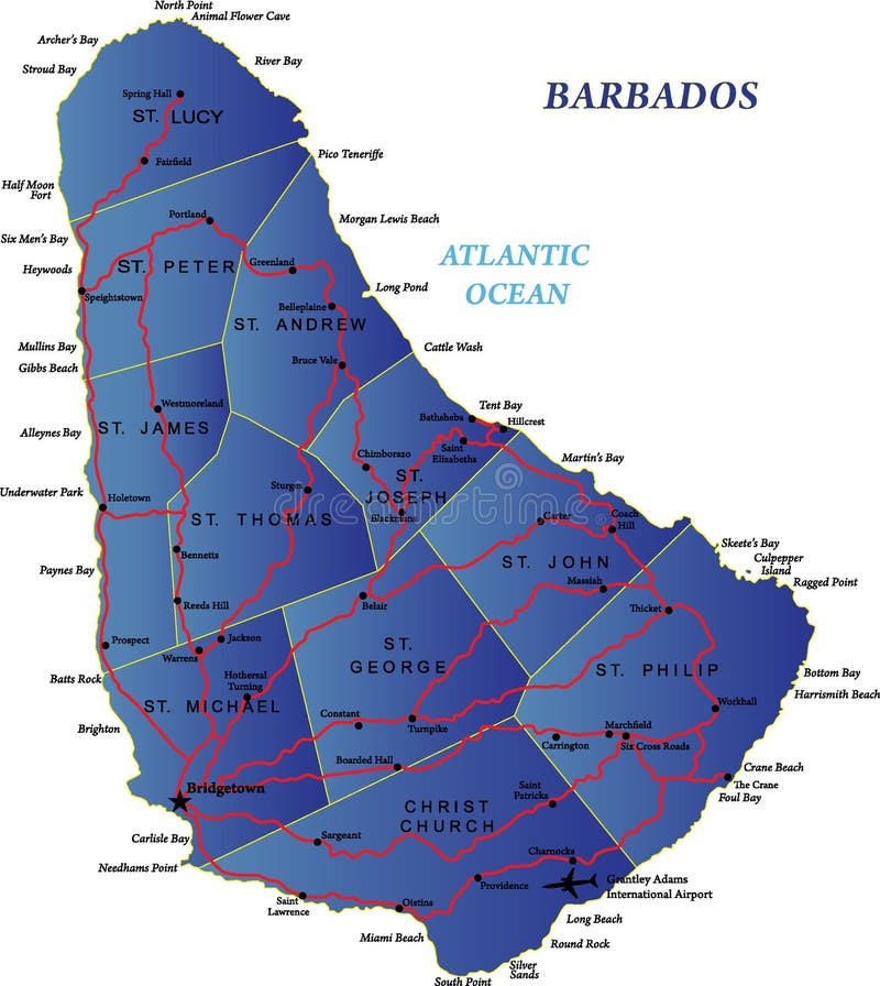
Free with trial Highly detailed map of Barbados with roads and maine cities. Bridgetown vectors Barbados map. Highly detailed map of Barbados with roads and maine cities. Highly detailed map of Barbados with roads and maine cities.
Free with trial Windward Islands, gray political map. Islands of Lesser Antilles, south of Leeward Islands in the Caribbean Sea. From Dominica, Martinique, Saint Lucia, Saint Vincent and the Grenadines, to Grenada. Bridgetown vectors Windward Islands, gray political map, islands in the Caribbean Sea. Windward Islands, gray political map. Islands of Lesser Antilles, south of Leeward Islands in. Windward Islands, gray political map. Islands of Lesser Antilles, south of Leeward Islands in the Caribbean Sea. From Dominica, Martinique, Saint Lucia, Saint Vincent and the Grenadines, to Grenada.
Free with trial Barbados, Grenada, Saint Lucia, Saint Vincent and the Grenadines political map. Caribbean islands, part of Lesser Antilles and Windward Islands. Gray illustration over white. English labeling. Vector. Bridgetown vectors Barbados, Grenada, Saint Lucia, Saint Vincent political map. Barbados, Grenada, Saint Lucia, Saint Vincent and the Grenadines political map. Caribbean islands. Barbados, Grenada, Saint Lucia, Saint Vincent and the Grenadines political map. Caribbean islands, part of Lesser Antilles and Windward Islands. Gray illustration over white. English labeling. Vector.
Free with trial Windward Islands political map. Islands of the Lesser Antilles, south of the Leeward Islands in the Caribbean Sea. From Dominica, Martinique, Saint Lucia, Saint Vincent and the Grenadines, to Grenada. Bridgetown vectors Windward Islands, political map, islands of Lesser Antilles in the Caribbean. Windward Islands political map. Islands of the Lesser Antilles, south of the. Windward Islands political map. Islands of the Lesser Antilles, south of the Leeward Islands in the Caribbean Sea. From Dominica, Martinique, Saint Lucia, Saint Vincent and the Grenadines, to Grenada.
Free with trial Barbados island highly detailed physical map. Highly detailed physical map of Barbados island ,in vector format,with all the relief forms,regions and big cities. Bridgetown vectors Barbados island highly detailed physical map. Highly detailed physical map of Barbados island ,in vector format,with all the relief forms,regions and big cities
Free with trial Vector road map of the Lesser Antilles island of Barbados. Bridgetown vectors Vector road map of the Lesser Antilles island of Barbados.
Free with trial Gradient Barbados map- vector illustration. Bridgetown vectors Gradient Barbados map. Vector illustration
Free with trial Saint Vincent and the Grenadines map, Caribbean island country. Bridgetown vectors Saint Vincent and the Grenadines map. Caribbean island country
Free with trial Blank map Barbados. High quality map of Barbados with provinces on transparent background for your web site design, logo, app, UI. Central America. EPS10. Bridgetown vectors Blank map Barbados. High quality map of Barbados with provinces on transparent background for your web site design, logo, app, UI. Central America. EPS10
Free with trial Barbados map. Vector of Barbados set with detailed country shape with region borders, flags and icons. Bridgetown vectors Barbados map. Vector of Barbados set with detailed country shape with region borders, flags and icons
Free with trial Barbados Flag icon, isolated on white background. Bridgetown vectors Barbados Flag icon. Isolated on white background
Free with trial Barbados flag garland white background with confetti, Hang bunting for Barbadian Independence Day celebration template banner, Vector illustration. Bridgetown vectors Barbados flag garland white background with confetti. Hang bunting for Barbadian Independence Day celebration template banner, Vector illustration
Free with trial Barbados official national flag and coat of arms, vector illustration, caribbean country. Bridgetown vectors Barbados official national flag and coat of arms. Vector illustration, caribbean country
Free with trial Flag of Barbados. Vector illustration on white background. Beautiful brush strokes. Abstract concept. Elements for design. Bridgetown vectors Flag of Barbados. Abstract concept. Flag of Barbados. Vector illustration on white background. Beautiful brush strokes. Abstract concept. Elements for design. Flag of Barbados. Vector illustration on white background. Beautiful brush strokes. Abstract concept. Elements for design.
Free with trial Flag of Barbados in the form of three hearts. Vector illustration on a white background. Brush strokes are drawn by hand. Independence Day. Bridgetown vectors Flag of Barbados in the form of three hearts. Vector illustration on a white background. Brush strokes are drawn by hand. Independence Day
Free with trial Flag of Barbodos. Vector illustration on a white background. Brush strokes are drawn by hand. Independence Day. Bridgetown vectors Flag of Barbodos. Brush strokes are drawn by hand. Independence Day. Flag of Barbodos. Vector illustration on a white background. Brush strokes are drawn by hand. Flag of Barbodos. Vector illustration on a white background. Brush strokes are drawn by hand. Independence Day
Free with trial Barbados map, vector pen drawing on black background. Vector sketch map of Barbados with flag, hand drawn chalk illustration. Grunge design. Bridgetown vectors Barbados map, vector pen drawing on black background. Vector sketch map of Barbados with flag, hand drawn chalk illustration. Grunge design
Free with trial A cartoon of flag barbados Army with machine gun. Vector illustration. Bridgetown vectors A cartoon of flag barbados Army with machine gun. Vector illustration
Free with trial Jamaica and Barbados flags for official meeting. Against background of world map. Bridgetown vectors Jamaica and Barbados flags for official meeting. Against background of world map
Free with trial Bridgetown outline map. Bridgetown (Mississippi) blank outline map. Bridgetown vectors Bridgetown outline map. Bridgetown (Mississippi) blank outline map. Bridgetown (Mississippi) blank outline map
Free with trial Bridgetown Historic District. Bridgetown Historic District hand drawn watercolor illustration. On white background. Bridgetown vectors Bridgetown Historic District. Bridgetown Historic District hand drawn watercolor illustration. On white background
Free with trial Bridgetown Historic District. Bridgetown Historic District hand drawn watercolor illustration. On white background. Bridgetown vectors Bridgetown Historic District. Bridgetown Historic District hand drawn watercolor illustration. On white background
Free with trial Bridgetown Historic District. Bridgetown Historic District hand drawn watercolor illustration. On white background. Bridgetown vectors Bridgetown Historic District. Bridgetown Historic District hand drawn watercolor illustration. On white background
Free with trial Bridgetown Historic District. Bridgetown Historic District hand drawn watercolor illustration. On white background. Bridgetown vectors Bridgetown Historic District. Bridgetown Historic District hand drawn watercolor illustration. On white background
Free with trial Bridgetown Historic District. Bridgetown Historic District hand drawn watercolor illustration. On white background. Bridgetown vectors Bridgetown Historic District. Bridgetown Historic District hand drawn watercolor illustration. On white background
Free with trial Bridgetown Historic District. Bridgetown Historic District hand drawn watercolor illustration. On white background. Bridgetown vectors Bridgetown Historic District. Bridgetown Historic District hand drawn watercolor illustration. On white background
Free with trial Bridgetown Historic District. Bridgetown Historic District hand drawn watercolor illustration. On white background. Bridgetown vectors Bridgetown Historic District. Bridgetown Historic District hand drawn watercolor illustration. On white background
Free with trial Bridgetown Historic District. Bridgetown Historic District hand drawn watercolor illustration. On white background. Bridgetown vectors Bridgetown Historic District. Bridgetown Historic District hand drawn watercolor illustration. On white background
Free with trial Bridgetown Historic District. Bridgetown Historic District hand drawn watercolor illustration. On white background. Bridgetown vectors Bridgetown Historic District. Bridgetown Historic District hand drawn watercolor illustration. On white background
Free with trial Bridgetown outline map. Bridgetown (Ohio) blank outline map. Bridgetown vectors Bridgetown outline map. Bridgetown (Ohio) blank outline map. Bridgetown (Ohio) blank outline map
Free with trial Outline illustration of Bridgetown Barbados skyline. Includes city buildings, landmarks and landscape silhouette Bridgetown skyline cityscape vector. Bridgetown vectors Bridgetown Barbados City Skyline Silhouette Outline on Transparent Background. Outline illustration of Bridgetown Barbados skyline. Includes city buildings. Outline illustration of Bridgetown Barbados skyline. Includes city buildings, landmarks and landscape silhouette Bridgetown skyline cityscape vector
Free with trial Bridgetown Barbados cityscape skyline silhouette with landmark outline illustration. Bridgetown travel landmarks illustration design. City tourism concept art. Bridgetown vectors Bridgetown Barbados Vector Cityscape Silhouette Landmark Outline Illustration. Bridgetown Barbados cityscape skyline silhouette with landmark outline. Bridgetown Barbados cityscape skyline silhouette with landmark outline illustration. Bridgetown travel landmarks illustration design. City tourism concept art
Free with trial Bridgetown, Barbados,detail Streets Roads Map with location pin, illustration vector element image. Bridgetown vectors Bridgetown, Barbados,detail Streets Roads Map with location pin. Illustration vector element image
Free with trial Bridgetown, Barbados Stamp Map Postal. Silhouette Seal Roads and Streets. Passport Round Design. Vector Icon. Design Retro Travel National Symbol. Bridgetown vectors Bridgetown, Barbados Stamp Map Postal. Silhouette Seal Roads and Streets. Passport Round Design. Vector Icon. Design Retro Travel National Symbol
Free with trial Vector illustration of four capital city silhouettes with labels for travel and geographical design concepts. Bridgetown vectors Global capital city skylines silhouettes including Nassau Manama Dhaka and Bridgetown set four. Vector illustration of four capital city silhouettes with labels. Vector illustration of four capital city silhouettes with labels for travel and geographical design concepts
Free with trial Vector silhouettes of famous capital cities featuring distinctive architectural landmarks and palm tree elements. Bridgetown vectors Detailed black silhouette of world city skylines Nassau Manama Dhaka and Bridgetown landmarks. Vector silhouettes of famous capital cities featuring distinctive. Vector silhouettes of famous capital cities featuring distinctive architectural landmarks and palm tree elements
Free with trial Four distinct city skyline silhouettes labeled Nassau Manama Dhaka and Bridgetown representing global travel destinations. Bridgetown vectors World city skylines silhouettes labeled with city names for travel and destination graphics. Four distinct city skyline silhouettes labeled Nassau Manama Dhaka. Four distinct city skyline silhouettes labeled Nassau Manama Dhaka and Bridgetown representing global travel destinations
Free with trial Barbados Low Poly Map Clip Art Design. Geometric Polygon Graphic National Icon. Vector Illustration Symbol. Bridgetown vectors Barbados Low Poly Map Clip Art Design. Geometric Polygon Graphic National Icon. Vector Illustration Symbol
Free with trial Barbados country dotted map. Black spot pixel illustration isolated on white background. Vector circle mosaic. Bridgetown vectors Barbados dotted vector map. Barbados country dotted map. Black spot pixel illustration isolated on white background. Vector circle mosaic. Barbados country dotted map. Black spot pixel illustration isolated on white background. Vector circle mosaic.
Free with trial Barbados water drop map silhouette. Barbados country silhouette. Vector map silhouette. Blue smooth shape like water drop or splash. Bridgetown vectors Barbados water drop map silhouette. Barbados country silhouette. Vector map silhouette. Blue smooth shape like water drop or splash
Free with trial Barbados country dotted map. Black spot pixel illustration isolated on white background. Vector circle mosaic. Bridgetown vectors Barbados dotted vector map. Barbados country dotted map. Black spot pixel illustration isolated on white background. Vector circle mosaic. Barbados country dotted map. Black spot pixel illustration isolated on white background. Vector circle mosaic.
Free with trial Stylized Map of Barbados with Neighboring Areas. Map in a modern, minimalistic style with soft gradient colors. Bridgetown vectors Stylized Map of Barbados with Neighboring Areas. Map in a modern, minimalistic style with soft gradient colors
Free with trial Barbados country black outline silhouettes in three different levels of smoothness. Simplified maps. Vector icons isolated on white background. Bridgetown vectors Barbados vector country map in three levels of smoothness. Barbados country black outline silhouettes in three different levels of smoothness. Simplified maps. Barbados country black outline silhouettes in three different levels of smoothness. Simplified maps. Vector icons isolated on white background.
Free with trial Barbados Map with City Names – Typography Vector Design. Of Barbados Country Map. Bridgetown vectors Barbados Map with City Names – Typography Vector Design. Of Barbados Country Map
Free with trial Barbados, Stamp Postal. Silhouette Seal. Passport Round Design. Vector Icon. Design Retro Travel. National Symbol Generative AI. Bridgetown vectors Barbados, Stamp Postal. Silhouette Seal Generative AI. Barbados, Stamp Postal. Silhouette Seal. Passport Round Design. Vector Icon. Design Retro Travel. National. Barbados, Stamp Postal. Silhouette Seal. Passport Round Design. Vector Icon. Design Retro Travel. National Symbol Generative AI.
Free with trial Abstract Map of Barbados and Surrounding Regions with Circular Patterns. Vibrant Abstract Map. Bridgetown vectors Abstract Map of Barbados and Surrounding Regions with Circular Patterns. Vibrant Abstract Map
Free with trial 3D Isometric Map Highlighting Barbados in Red. Vector illustration. Bridgetown vectors 3D Isometric Map Highlighting Barbados in Red. Vector illustration
Free with trial Barbados highlighted on a detailed map, geographic location of Barbados. Vector Map. Bridgetown vectors Barbados highlighted on a detailed map, geographic location of Barbados. Vector Map
Free with trial Barbados Map in Blue with Gold Framed Accents. Modern Vector Map of Barbados. Vector Illustration. Bridgetown vectors Barbados Map in Blue with Gold Framed Accents. Modern Vector Map of Barbados. Vector Illustration
Free with trial Barbados country silhouette. High detailed map. Solid blue vector sticker with white contour isolated on white background. Bridgetown vectors Barbados vector country map sticker. Barbados country silhouette. High detailed map. Solid blue vector sticker with white contour isolated on white background. Barbados country silhouette. High detailed map. Solid blue vector sticker with white contour isolated on white background.
Free with trial Barbados country simplified map. Orange silhouette with thick black sharp contour outline isolated on white background. Simple vector icon. Bridgetown vectors Barbados simplified vector map. Barbados country simplified map. Orange silhouette with thick black sharp contour outline isolated on white background. Simple. Barbados country simplified map. Orange silhouette with thick black sharp contour outline isolated on white background. Simple vector icon
Free with trial Barbados high detailed vector representation of country silhouette in solid black on white background. For educational, decorative, or informational use showcasing the national outline. Bridgetown vectors Barbados vector map silhouette. Barbados high detailed vector representation of country silhouette in solid black on white background. For educational. Barbados high detailed vector representation of country silhouette in solid black on white background. For educational, decorative, or informational use showcasing the national outline.
Free with trial Barbados high detailed vector representation of country silhouette. 3D map on transparent background with dropped shadow. For educational, decorative, or informational use. Bridgetown vectors Barbados vector map silhouette. Barbados high detailed vector representation of country silhouette. 3D map on transparent background with dropped shadow. For. Barbados high detailed vector representation of country silhouette. 3D map on transparent background with dropped shadow. For educational, decorative, or informational use.
Free with trial Barbados flag shiny golden and silver icons isolated on black and white. Vector 3D square rounded illuminated buttons with shadow. Use for bets, tournament, olympic and sport games. Bridgetown vectors Barbados flag shiny golden and silver icons isolated on black and white. Vector. 3D square rounded illuminated buttons with shadow. Use for bets, tournament
Free with trial Barbados flag in flat oval design. Barbados flag symbolizing national pride, identity, heritage, patriotism and authority. Vector flag in flat oval design. Bridgetown vectors Barbados flag in flat oval design. Barbados flag symbolizing national pride, identity, heritage, patriotism and authority. Vector flag in flat oval design
Free with trial Stamp Postal of Barbados. Flag of Barbados Silhouette rubber Seal. Design Retro Travel. Seal of Barbados. Grunge for your design. EPS10. Bridgetown vectors Stamp Postal of Barbados. Flag of Barbados Silhouette rubber Seal. Design Retro Travel. Seal of Barbados. Grunge for your design. EPS10
Free with trial Simple colorful isolated vector map of Caribbean island state Barbados. Bridgetown vectors Simple isolated vector map of Caribbean island state Barbados. Simple colorful isolated vector map of Caribbean island state Barbados. Simple colorful isolated vector map of Caribbean island state Barbados.
Free with trial Barbados waving effect flag. Barbados flag with wavy silk effect. Vector flag symbolizing national pride, identity, heritage, patriotism and authority. Bridgetown vectors Barbados waving effect flag. Barbados flag with wavy silk effect. Vector flag symbolizing national pride, identity, heritage, patriotism and authority
Free with trial Barbados Country Map Featuring National Flag Colors. Vector illustration. Bridgetown vectors Barbados Country Map Featuring National Flag Colors. Vector illustration
Free with trial Barbados flag - wavy stick flag of country, cultural identity and heritage. Represents national pride and unity. Vector table flag hanged on the short hoist. Isolated on white background. Bridgetown vectors Flag of Barbados. Barbados flag - wavy stick flag of country, cultural identity and heritage. Represents national pride and unity. Vector table flag hanged on. Barbados flag - wavy stick flag of country, cultural identity and heritage. Represents national pride and unity. Vector table flag hanged on the short hoist. Isolated on white background
Free with trial Detailed map of Barbados filled with the national flag colors and a distressed grunge wall texture. Caribbean island nation located in the Atlantic Ocean, known for its tropical beaches, tourism, and cultural heritage. Ideal for travel, geography, and editorial design projects with a bold urban style. Bridgetown vectors Barbados map with national flag texture and grunge wall effect. Detailed map of Barbados filled with the national flag colors and a distressed grunge wall. Detailed map of Barbados filled with the national flag colors and a distressed grunge wall texture. Caribbean island nation located in the Atlantic Ocean, known for its tropical beaches, tourism, and cultural heritage. Ideal for travel, geography, and editorial design projects with a bold urban style.
Free with trial Barbados vertical flag in official colors, dimensions and aspect ratio. Vector flag symbolizing national pride, identity, heritage, patriotism and authority. Bridgetown vectors Barbados flag turned to vertical position. Barbados vertical flag in official colors, dimensions and aspect ratio. Vector flag symbolizing national pride. Barbados vertical flag in official colors, dimensions and aspect ratio. Vector flag symbolizing national pride, identity, heritage, patriotism and authority
 Sign in