Free with trial A simple line drawing of a location pin icon in a circular shape with curved lines on either side and a small circle at the bottom. Coordinates vectors A black line drawing of a location pin in a circle with curved lines on a is shown. A simple line drawing of a location pin icon in a circular shape with curved. a simple line drawing of a location pin icon in a circular shape with curved lines on either side and a small circle at the bottom
Free with trial A map with location pins, a man using a laptop, and a woman pointing. Ideal for themes business, teamwork, global communication, navigation, technology. Simple, clean style. Coordinates vectors Location Pins and Business Team with World Map Interface. A map with location pins, a man using a laptop, and a woman pointing. Ideal for themes business. A map with location pins, a man using a laptop, and a woman pointing. Ideal for themes business, teamwork, global communication, navigation, technology. Simple, clean style
Free with trial A black silhouette of a folded paper navigation map with a compass arrow on a plain white background, detailed graphic. Coordinates vectors Folded paper navigation map with compass arrow silhouette isolated on white. A black silhouette of a folded paper navigation map with a compass arrow on a plain. A black silhouette of a folded paper navigation map with a compass arrow on a plain white background, detailed graphic
Free with trial A black silhouette of an ornate nautical compass with circular markings on a plain white background, detailed graphic. Coordinates vectors Ornate nautical compass with circular markings silhouette isolated on white. A black silhouette of an ornate nautical compass with circular markings on a plain. A black silhouette of an ornate nautical compass with circular markings on a plain white background, detailed graphic
Free with trial A bold glyph of measuring wheel in a solid style designed for land surveying, civil engineering and mapping projects. the monochrome artwork has smooth curves, sharp corners and a clear readable outline, which keeps it legible on any background. designers can use it for buttons, labels, signage, social posts, educational material and layouts that need a quick visual cue. Coordinates vectors Measuring wheel solid icon black glyph silhouette vector symbol for surveying. A bold glyph of measuring wheel in a solid style designed for land surveying. A bold glyph of measuring wheel in a solid style designed for land surveying, civil engineering and mapping projects. the monochrome artwork has smooth curves, sharp corners and a clear readable outline, which keeps it legible on any background. designers can use it for buttons, labels, signage, social posts, educational material and layouts that need a quick visual cue.
Free with trial A simple black map pin marker with a circular base representing location or navigation isolated on a clean white background. Coordinates vectors Black Map Pin Marker with Concentric Circle Base Isolated on White Background. A simple black map pin marker with a circular base representing location or. A simple black map pin marker with a circular base representing location or navigation isolated on a clean white background
Free with trial A bold glyph of handheld gnss controller designed for land surveying, civil engineering and mapping projects. the monochrome artwork has smooth curves, sharp corners and a clear readable outline, which keeps it legible on any background. designers can use it for buttons, labels, signage, social posts, educational material and layouts that need a quick visual cue. Coordinates vectors Handheld gnss controller vector icon solid black pictogram sign for surveying. A bold glyph of handheld gnss controller designed for land surveying, civil. A bold glyph of handheld gnss controller designed for land surveying, civil engineering and mapping projects. the monochrome artwork has smooth curves, sharp corners and a clear readable outline, which keeps it legible on any background. designers can use it for buttons, labels, signage, social posts, educational material and layouts that need a quick visual cue.
Free with trial This elevation mountain arrows symbol is a simple black pictogram created for land surveying, civil engineering and mapping projects. its minimal design communicates the idea instantly without extra detail. use it as a navigation element, a menu marker, a slide graphic, a poster accent or a visual aid in reports and tutorials. the isolated shape on white makes editing and placement quick and flexible. Coordinates vectors Elevation mountain arrows symbol flat black icon design element for surveying. This elevation mountain arrows symbol is a simple black pictogram created for land. This elevation mountain arrows symbol is a simple black pictogram created for land surveying, civil engineering and mapping projects. its minimal design communicates the idea instantly without extra detail. use it as a navigation element, a menu marker, a slide graphic, a poster accent or a visual aid in reports and tutorials. the isolated shape on white makes editing and placement quick and flexible.
Free with trial This terrain elevation contour symbol is a simple black pictogram created for land surveying, civil engineering and mapping projects. its minimal design communicates the idea instantly without extra detail. use it as a navigation element, a menu marker, a slide graphic, a poster accent or a visual aid in reports and tutorials. the isolated shape on white makes editing and placement quick and flexible. Coordinates vectors Terrain elevation contour symbol flat black icon design element for surveying. This terrain elevation contour symbol is a simple black pictogram created for land. This terrain elevation contour symbol is a simple black pictogram created for land surveying, civil engineering and mapping projects. its minimal design communicates the idea instantly without extra detail. use it as a navigation element, a menu marker, a slide graphic, a poster accent or a visual aid in reports and tutorials. the isolated shape on white makes editing and placement quick and flexible.
Free with trial A bold glyph of handheld laser distance meter designed for land surveying, civil engineering and mapping projects. the monochrome artwork has smooth curves, sharp corners and a clear readable outline, which keeps it legible on any background. designers can use it for buttons, labels, signage, social posts, educational material and layouts that need a quick visual cue. Coordinates vectors Handheld laser distance meter black icon isolated glyph graphic for surveying. A bold glyph of handheld laser distance meter designed for land surveying, civil. A bold glyph of handheld laser distance meter designed for land surveying, civil engineering and mapping projects. the monochrome artwork has smooth curves, sharp corners and a clear readable outline, which keeps it legible on any background. designers can use it for buttons, labels, signage, social posts, educational material and layouts that need a quick visual cue.
Free with trial This image was created using Generative AI. Collection of five dark blue location pin icons on white background. Features GPS markers, satellite dish, globe, and mobile phone symbols. Ideal for navigation, mapping, and technology UI designs. Coordinates vectors Set of five dark blue GPS location pin icons with satellite and mobile design. This image was created using Generative AI. Collection of five dark blue location. This image was created using Generative AI. Collection of five dark blue location pin icons on white background. Features GPS markers, satellite dish, globe, and mobile phone symbols. Ideal for navigation, mapping, and technology UI designs
Free with trial This surveyor with theodolite symbol in a flat style is a simple black pictogram created for land surveying, civil engineering and mapping projects. its minimal design communicates the idea instantly without extra detail. use it as a navigation element, a menu marker, a slide graphic, a poster accent or a visual aid in reports and tutorials. the isolated shape on white makes editing and placement quick and flexible. Coordinates vectors Surveyor with theodolite flat black icon isolated glyph graphic for surveying. This surveyor with theodolite symbol in a flat style is a simple black pictogram. This surveyor with theodolite symbol in a flat style is a simple black pictogram created for land surveying, civil engineering and mapping projects. its minimal design communicates the idea instantly without extra detail. use it as a navigation element, a menu marker, a slide graphic, a poster accent or a visual aid in reports and tutorials. the isolated shape on white makes editing and placement quick and flexible.
Free with trial Vector graph or chart of cubing, cube or cubic function, polynomial function of degree 3 with formula or equation f(x) x3. The mathematical operation, basic function. Graph with grid and coordinates isolated on a white background. Coordinates vectors Vector graph or chart of cubing, cube, or cubic function, polynomial function of degree 3. The mathematical operation. Vector graph or chart of cubing, cube or. Vector graph or chart of cubing, cube or cubic function, polynomial function of degree 3 with formula or equation f(x) x3. The mathematical operation, basic function. Graph with grid and coordinates isolated on a white background.
Free with trial Detailed infographic and map of Quitman County in Georgia. USA. Coordinates vectors Detailed infographic and map of Quitman County in Georgia. USA
Free with trial Detailed infographic and map of Pulaski County in Georgia. USA. Coordinates vectors Detailed infographic and map of Pulaski County in Georgia. USA
Free with trial Detailed infographic and map of Screven County in Georgia. USA. Coordinates vectors Detailed infographic and map of Screven County in Georgia. USA
Free with trial Map of Heard Island and McDonald Islands in the Australian external territory. Coordinates vectors Map of Heard Island and McDonald Islands in the Australian external territory.
Free with trial Structure molecule and communication. Dna, atom, neurons. Scientific concept for your design. Connected lines with dots. Medical, technology, chemistry, science background illustration. Coordinates vectors Structure molecule and communication. Dna, atom, neurons. Scientific concept for your design. Connected lines with dots. Medical. Technology, chemistry. Structure molecule and communication. Dna, atom, neurons. Scientific concept for your design. Connected lines with dots. Medical, technology, chemistry, science background illustration
Free with trial Black map pin icon with three locations connected by lines vector illustration. Black map pin icon with three locations connected by lines on white background. Coordinates vectors Black map pin icon with three locations connected by lines vector illustration. Black map pin icon with three locations connected by lines on white background
Free with trial Man conductor participates in acoustic concert and helps orchestra perform classical symphony for audience of performance. Conductor in formal suit and bow tie coordinates musicians from opera house. Coordinates vectors Man conductor participates in acoustic concert and helps orchestra perform classical symphony. For audience of performance. Conductor in formal suit and bow tie. Man conductor participates in acoustic concert and helps orchestra perform classical symphony for audience of performance. Conductor in formal suit and bow tie coordinates musicians from opera house
Free with trial Illustration of a smartphone displaying a map with a route and pins, connected to a satellite, symbolizing GPS technology and location tracking. Coordinates vectors Smartphone GPS Navigation System with Satellite Connection and Route Tracking. Illustration of a smartphone displaying a map with a route and pins, connected to. Illustration of a smartphone displaying a map with a route and pins, connected to a satellite, symbolizing GPS technology and location tracking
Free with trial A bold glyph of measuring wheel in a simple style designed for land surveying, civil engineering and mapping projects. the monochrome artwork has smooth curves, sharp corners and a clear readable outline, which keeps it legible on any background. designers can use it for buttons, labels, signage, social posts, educational material and layouts that need a quick visual cue. Coordinates vectors Measuring wheel simple icon black glyph silhouette vector symbol for surveying. A bold glyph of measuring wheel in a simple style designed for land surveying. A bold glyph of measuring wheel in a simple style designed for land surveying, civil engineering and mapping projects. the monochrome artwork has smooth curves, sharp corners and a clear readable outline, which keeps it legible on any background. designers can use it for buttons, labels, signage, social posts, educational material and layouts that need a quick visual cue.
Free with trial This survey instrument dial symbol is a simple black pictogram created for land surveying, civil engineering and mapping projects. its minimal design communicates the idea instantly without extra detail. use it as a navigation element, a menu marker, a slide graphic, a poster accent or a visual aid in reports and tutorials. the isolated shape on white makes editing and placement quick and flexible. Coordinates vectors Survey instrument dial icon black glyph silhouette vector symbol for surveying. This survey instrument dial symbol is a simple black pictogram created for land. This survey instrument dial symbol is a simple black pictogram created for land surveying, civil engineering and mapping projects. its minimal design communicates the idea instantly without extra detail. use it as a navigation element, a menu marker, a slide graphic, a poster accent or a visual aid in reports and tutorials. the isolated shape on white makes editing and placement quick and flexible.
Free with trial Leveling rod in circle icon drawn as a solid black silhouette with clean edges and balanced proportions. this vector pictogram suits land surveying, civil engineering and mapping projects. the simple shapes remain clear at small sizes, so it works well in websites, mobile apps, infographics, presentations, printed materials and interface layouts. it is isolated on a white background and is easy to recolor, scale and combine with other graphics. Coordinates vectors Leveling rod in circle icon black glyph silhouette vector symbol for surveying. Leveling rod in circle icon drawn as a solid black silhouette with clean edges. Leveling rod in circle icon drawn as a solid black silhouette with clean edges and balanced proportions. this vector pictogram suits land surveying, civil engineering and mapping projects. the simple shapes remain clear at small sizes, so it works well in websites, mobile apps, infographics, presentations, printed materials and interface layouts. it is isolated on a white background and is easy to recolor, scale and combine with other graphics.
Free with trial Tape measure roll in a flat style icon drawn as a solid black silhouette with clean edges and balanced proportions. this vector pictogram suits land surveying, civil engineering and mapping projects. the simple shapes remain clear at small sizes, so it works well in websites, mobile apps, infographics, presentations, printed materials and interface layouts. it is isolated on a white background and is easy to recolor, scale and combine with other graphics. Coordinates vectors Tape measure roll flat icon black glyph silhouette vector symbol for surveying. Tape measure roll in a flat style icon drawn as a solid black silhouette with. Tape measure roll in a flat style icon drawn as a solid black silhouette with clean edges and balanced proportions. this vector pictogram suits land surveying, civil engineering and mapping projects. the simple shapes remain clear at small sizes, so it works well in websites, mobile apps, infographics, presentations, printed materials and interface layouts. it is isolated on a white background and is easy to recolor, scale and combine with other graphics.
Free with trial This image depicts a detailed illustration of the Earth with marked locations on a white background. The globe is shown with a grid pattern and lines connecting various points, representing connections and relationships between different parts of the world. The illustration is likely used for educational or informational purposes, highlighting the importance of global understanding and cooperation. Coordinates vectors A detailed illustration of the Earth with marked locations on a white background. This image depicts a detailed illustration of the Earth with marked locations. This image depicts a detailed illustration of the Earth with marked locations on a white background. The globe is shown with a grid pattern and lines connecting various points, representing connections and relationships between different parts of the world. The illustration is likely used for educational or informational purposes, highlighting the importance of global understanding and cooperation.
Free with trial This surveyor with leveling rod symbol is a simple black pictogram created for land surveying, civil engineering and mapping projects. its minimal design communicates the idea instantly without extra detail. use it as a navigation element, a menu marker, a slide graphic, a poster accent or a visual aid in reports and tutorials. the isolated shape on white makes editing and placement quick and flexible. Coordinates vectors Surveyor with leveling rod symbol flat black icon design element for surveying. This surveyor with leveling rod symbol is a simple black pictogram created for. This surveyor with leveling rod symbol is a simple black pictogram created for land surveying, civil engineering and mapping projects. its minimal design communicates the idea instantly without extra detail. use it as a navigation element, a menu marker, a slide graphic, a poster accent or a visual aid in reports and tutorials. the isolated shape on white makes editing and placement quick and flexible.
Free with trial Leveling rod crosshair icon drawn as a solid black silhouette with clean edges and balanced proportions. this vector pictogram suits land surveying, civil engineering and mapping projects. the simple shapes remain clear at small sizes, so it works well in websites, mobile apps, infographics, presentations, printed materials and interface layouts. it is isolated on a white background and is easy to recolor, scale and combine with other graphics. Coordinates vectors Leveling rod crosshair icon black glyph silhouette vector symbol for surveying. Leveling rod crosshair icon drawn as a solid black silhouette with clean edges. Leveling rod crosshair icon drawn as a solid black silhouette with clean edges and balanced proportions. this vector pictogram suits land surveying, civil engineering and mapping projects. the simple shapes remain clear at small sizes, so it works well in websites, mobile apps, infographics, presentations, printed materials and interface layouts. it is isolated on a white background and is easy to recolor, scale and combine with other graphics.
Free with trial This image was created using Generative AI. A black map pin icon with a white circle and an abstract line on a white background. Coordinates vectors Black map pin icon with abstract line on white background symbolizing location. This image was created using Generative AI. A black map pin icon with a white. This image was created using Generative AI. A black map pin icon with a white circle and an abstract line on a white background
Free with trial This laser rangefinder symbol in a bold style is a simple black pictogram created for land surveying, civil engineering and mapping projects. its minimal design communicates the idea instantly without extra detail. use it as a navigation element, a menu marker, a slide graphic, a poster accent or a visual aid in reports and tutorials. the isolated shape on white makes editing and placement quick and flexible. Coordinates vectors Laser rangefinder bold icon black glyph silhouette vector symbol for surveying. This laser rangefinder symbol in a bold style is a simple black pictogram created. This laser rangefinder symbol in a bold style is a simple black pictogram created for land surveying, civil engineering and mapping projects. its minimal design communicates the idea instantly without extra detail. use it as a navigation element, a menu marker, a slide graphic, a poster accent or a visual aid in reports and tutorials. the isolated shape on white makes editing and placement quick and flexible.
Free with trial A collection of eighteen black arranged in a three-by-six grid on a white background. The set includes various map pins, compasses with cardinal directions, folded paper maps, satellite imagery, directional arrows, road signs, and path markers. Each a solid black silhouette style with clean, bold lines, representing concepts related to navigation, global positioning systems, travel, and route. Coordinates vectors Set of black navigation featuring map pins, compasses, satellites, and route signs. A collection of eighteen black arranged in a three-by-six grid on a white. A collection of eighteen black arranged in a three-by-six grid on a white background. The set includes various map pins, compasses with cardinal directions, folded paper maps, satellite imagery, directional arrows, road signs, and path markers. Each a solid black silhouette style with clean, bold lines, representing concepts related to navigation, global positioning systems, travel, and route
Free with trial 'A dashboard-style computer screen displays a satellite map with layered data points, surrounded by precise graphs and charts, offering a data-rich visualization of complex trends and patterns. Coordinates vectors A computer screen with a map and graphs. 'A dashboard-style computer screen displays a satellite map with layered data points, surrounded by precise graphs and. 'A dashboard-style computer screen displays a satellite map with layered data points, surrounded by precise graphs and charts, offering a data-rich visualization of complex trends and patterns
Free with trial Detailed infographic and map of Sumter County in Georgia. USA. Coordinates vectors Detailed infographic and map of Sumter County in Georgia. USA
Free with trial Detailed infographic and map of Taylor County in Georgia. USA. Coordinates vectors Detailed infographic and map of Taylor County in Georgia. USA
Free with trial Detailed infographic and map of Talbot County in Georgia. USA. Coordinates vectors Detailed infographic and map of Talbot County in Georgia. USA
Free with trial Arrow expansion icon. Black directional symbol. Four way vector. Navigation simple design. EPS 10. Coordinates vectors Arrow expansion icon. Black directional symbol. Four way vector. Navigation simple design. EPS 10
Free with trial Map of Miller County in Georgia USA. Detailed infographic and map of Miller County in Georgia USA. Coordinates vectors Map of Miller County in Georgia USA. Detailed infographic and map of Miller County in Georgia USA
Free with trial Map of Monroe County in Georgia USA. Detailed infographic and map of Monroe County in Georgia USA. Coordinates vectors Map of Monroe County in Georgia USA. Detailed infographic and map of Monroe County in Georgia USA
Free with trial Map of Morgan County in Georgia USA. Detailed infographic and map of Morgan County in Georgia USA. Coordinates vectors Map of Morgan County in Georgia USA. Detailed infographic and map of Morgan County in Georgia USA
Free with trial Structure molecule and communication. Dna, atom, neurons. Scientific concept for your design. Connected lines with dots. Medical, technology, chemistry, science background illustration. Coordinates vectors Structure molecule and communication. Dna, atom, neurons. Scientific concept for your design. Connected lines with dots. Medical. Technology, chemistry. Structure molecule and communication. Dna, atom, neurons. Scientific concept for your design. Connected lines with dots. Medical, technology, chemistry, science background illustration
Free with trial This vector illustration displays a simplified globe with a red location pin marking a spot, symbolizing navigation and global positioning, clear and modern mood. Generative AI. Coordinates vectors Globe with Location Pin Icon for Global Positioning and Navigation Purposes in Vector Format. This vector illustration displays a simplified globe with a red. This vector illustration displays a simplified globe with a red location pin marking a spot, symbolizing navigation and global positioning, clear and modern mood. Generative AI
Free with trial A minimalist black navigation route symbol featuring a path connecting start and destination map pins. Coordinates vectors Black Navigation Route Icon with Start and Destination Location Pins Vector. A minimalist black navigation route symbol featuring a path connecting start and. A minimalist black navigation route symbol featuring a path connecting start and destination map pins
Free with trial A black silhouette of a clear round navigation compass arrow indicator on a plain white background, detailed graphic. Coordinates vectors Clear round navigation compass arrow indicator silhouette on white background. A black silhouette of a clear round navigation compass arrow indicator on a plain. A black silhouette of a clear round navigation compass arrow indicator on a plain white background, detailed graphic
Free with trial This 3D illustration features a red map pin icon with a central hole, representing location, navigation, and mapping. Ideal for digital apps, travel visuals, or geographic interface designs. Coordinates vectors 3D illustration of red map pin with central hole, symbolizing location, navigation, and digital mapping. This 3D illustration features a red map pin icon with a. This 3D illustration features a red map pin icon with a central hole, representing location, navigation, and mapping. Ideal for digital apps, travel visuals, or geographic interface designs.
Free with trial Detailed infographic and map of Rockdale County in Georgia. USA. Coordinates vectors Detailed infographic and map of Rockdale County in Georgia. USA
Free with trial Detailed infographic and map of Randolph County in Georgia. USA. Coordinates vectors Detailed infographic and map of Randolph County in Georgia. USA
Free with trial Detailed infographic and map of Richmond County in Georgia. USA. Coordinates vectors Detailed infographic and map of Richmond County in Georgia. USA
Free with trial Laser rangefinder in circle icon drawn as a solid black silhouette with clean edges and balanced proportions. this vector pictogram suits land surveying, civil engineering and mapping projects. the simple shapes remain clear at small sizes, so it works well in websites, mobile apps, infographics, presentations, printed materials and interface layouts. it is isolated on a white background and is easy to recolor, scale and combine with other graphics. Coordinates vectors Laser rangefinder in circle symbol flat black icon design element for surveying. Laser rangefinder in circle icon drawn as a solid black silhouette with clean. Laser rangefinder in circle icon drawn as a solid black silhouette with clean edges and balanced proportions. this vector pictogram suits land surveying, civil engineering and mapping projects. the simple shapes remain clear at small sizes, so it works well in websites, mobile apps, infographics, presentations, printed materials and interface layouts. it is isolated on a white background and is easy to recolor, scale and combine with other graphics.
Free with trial A bold glyph of distance measurement arrow designed for land surveying, civil engineering and mapping projects. the monochrome artwork has smooth curves, sharp corners and a clear readable outline, which keeps it legible on any background. designers can use it for buttons, labels, signage, social posts, educational material and layouts that need a quick visual cue. Coordinates vectors Distance measurement arrow vector icon solid black pictogram sign for surveying. A bold glyph of distance measurement arrow designed for land surveying, civil. A bold glyph of distance measurement arrow designed for land surveying, civil engineering and mapping projects. the monochrome artwork has smooth curves, sharp corners and a clear readable outline, which keeps it legible on any background. designers can use it for buttons, labels, signage, social posts, educational material and layouts that need a quick visual cue.
Free with trial A bold glyph of laser rangefinder in a solid style designed for land surveying, civil engineering and mapping projects. the monochrome artwork has smooth curves, sharp corners and a clear readable outline, which keeps it legible on any background. designers can use it for buttons, labels, signage, social posts, educational material and layouts that need a quick visual cue. Coordinates vectors Laser rangefinder solid icon black glyph silhouette vector symbol for surveying. A bold glyph of laser rangefinder in a solid style designed for land surveying. A bold glyph of laser rangefinder in a solid style designed for land surveying, civil engineering and mapping projects. the monochrome artwork has smooth curves, sharp corners and a clear readable outline, which keeps it legible on any background. designers can use it for buttons, labels, signage, social posts, educational material and layouts that need a quick visual cue.
Free with trial Total station on tripod icon drawn as a solid black silhouette with clean edges and balanced proportions. this vector pictogram suits land surveying, civil engineering and mapping projects. the simple shapes remain clear at small sizes, so it works well in websites, mobile apps, infographics, presentations, printed materials and interface layouts. it is isolated on a white background and is easy to recolor, scale and combine with other graphics. Coordinates vectors Total station on tripod icon black glyph silhouette vector symbol for surveying. Total station on tripod icon drawn as a solid black silhouette with clean edges. Total station on tripod icon drawn as a solid black silhouette with clean edges and balanced proportions. this vector pictogram suits land surveying, civil engineering and mapping projects. the simple shapes remain clear at small sizes, so it works well in websites, mobile apps, infographics, presentations, printed materials and interface layouts. it is isolated on a white background and is easy to recolor, scale and combine with other graphics.
Free with trial Abstract topographic map illustration with contour lines on a dark background. The design features elevation curves and coordinates, creating a modern cartography concept. Vector illustration. Coordinates vectors Topographic map design. Vector illustration. Abstract topographic map illustration with contour lines on a dark background. The design features elevation curves. Abstract topographic map illustration with contour lines on a dark background. The design features elevation curves and coordinates, creating a modern cartography concept. Vector illustration
Free with trial A set of 25 diverse circular target icons, perfect for business, technology, and marketing projects. These versatile icons symbolize accuracy, goals, and objectives. Coordinates vectors Collection of Circular Target Icons: Aiming for Success. A set of 25 diverse circular target icons, perfect for business, technology, and marketing projects. A set of 25 diverse circular target icons, perfect for business, technology, and marketing projects. These versatile icons symbolize accuracy, goals, and objectives.
Free with trial A minimalist black graphic icon depicting three arrows representing a three-dimensional coordinate system axis. Coordinates vectors Three Dimensional Axis Arrows Icon Showing Mathematical X Y Z Coordinates In. A minimalist black graphic icon depicting three arrows representing a three. A minimalist black graphic icon depicting three arrows representing a three-dimensional coordinate system axis
Free with trial Professionals shaking hands while a colleague coordinates and points at a target. Contains work files and briefcase. Ideal for teamwork, business goals, collaboration, leadership, agreements. Coordinates vectors Team collaboration with handshake, discussion, and task management in minimalistic style. Professionals shaking hands while a colleague coordinates and points at. Professionals shaking hands while a colleague coordinates and points at a target. Contains work files and briefcase. Ideal for teamwork, business goals, collaboration, leadership, agreements
Free with trial Detailed infographic and map of Telfair County in Georgia. USA. Coordinates vectors Detailed infographic and map of Telfair County in Georgia. USA
Free with trial Detailed infographic and map of Stewart County in Georgia. USA. Coordinates vectors Detailed infographic and map of Stewart County in Georgia. USA
Free with trial Map of Madison County in Georgia USA. Detailed infographic and map of Madison County in Georgia USA. Coordinates vectors Map of Madison County in Georgia USA. Detailed infographic and map of Madison County in Georgia USA
Free with trial A minimalistic black-and-white vector graphic characterized by its straightforward lines and an eye-catching use of contrasting shades - Artificial intelligence crafted illustration. Coordinates vectors Gps - minimalist and flat logo - vector illustration. A minimalistic black-and-white vector graphic characterized by its straightforward lines and an eye. A minimalistic black-and-white vector graphic characterized by its straightforward lines and an eye-catching use of contrasting shades - Artificial intelligence crafted illustration
Free with trial Vector graph or chart of a goniometric or trigonometric function. Sine or cosine function. The mathematical operation, basic function. Graph with grid and coordinates isolated on a white background. Coordinates vectors Vector graph or chart of a goniometric or trigonometric function. Sine or cosine function. The mathematical operation. Basic function. Graph with grid and. Vector graph or chart of a goniometric or trigonometric function. Sine or cosine function. The mathematical operation, basic function. Graph with grid and coordinates isolated on a white background.
Free with trial A bold glyph of distance measurement circle designed for land surveying, civil engineering and mapping projects. the monochrome artwork has smooth curves, sharp corners and a clear readable outline, which keeps it legible on any background. designers can use it for buttons, labels, signage, social posts, educational material and layouts that need a quick visual cue. Coordinates vectors Distance measurement circle vector icon solid black pictogram sign for surveying. A bold glyph of distance measurement circle designed for land surveying, civil. A bold glyph of distance measurement circle designed for land surveying, civil engineering and mapping projects. the monochrome artwork has smooth curves, sharp corners and a clear readable outline, which keeps it legible on any background. designers can use it for buttons, labels, signage, social posts, educational material and layouts that need a quick visual cue.
Free with trial A bold glyph of elevation benchmark triangle designed for land surveying, civil engineering and mapping projects. the monochrome artwork has smooth curves, sharp corners and a clear readable outline, which keeps it legible on any background. designers can use it for buttons, labels, signage, social posts, educational material and layouts that need a quick visual cue. Coordinates vectors Elevation benchmark triangle symbol flat black icon design element for surveying. A bold glyph of elevation benchmark triangle designed for land surveying, civil. A bold glyph of elevation benchmark triangle designed for land surveying, civil engineering and mapping projects. the monochrome artwork has smooth curves, sharp corners and a clear readable outline, which keeps it legible on any background. designers can use it for buttons, labels, signage, social posts, educational material and layouts that need a quick visual cue.
Free with trial This image was created using Generative AI. Collection of black and white earth globe maps featuring location pin icons. Ideal for travel, navigation, and global connectivity concepts. Clean design for web and print. Coordinates vectors Black and White Earth Globe Map With Location Pin Icon Set For Travel Navigation. This image was created using Generative AI. Collection of black and white earth. This image was created using Generative AI. Collection of black and white earth globe maps featuring location pin icons. Ideal for travel, navigation, and global connectivity concepts. Clean design for web and print
Free with trial This image was created using Generative AI. Flat design icon collection featuring map pins, compass, GPS signal, and travel modes. Ideal for apps, websites, and navigation interfaces. Clean blue and red color palette. Coordinates vectors Navigation and Location Icons Set with Map Pins Compass GPS Route and Travel Symbols. This image was created using Generative AI. Flat design icon collection. This image was created using Generative AI. Flat design icon collection featuring map pins, compass, GPS signal, and travel modes. Ideal for apps, websites, and navigation interfaces. Clean blue and red color palette
Free with trial A bold glyph of terrain survey in circle designed for land surveying, civil engineering and mapping projects. the monochrome artwork has smooth curves, sharp corners and a clear readable outline, which keeps it legible on any background. designers can use it for buttons, labels, signage, social posts, educational material and layouts that need a quick visual cue. Coordinates vectors Terrain survey in circle icon black glyph silhouette vector symbol for surveying. A bold glyph of terrain survey in circle designed for land surveying, civil. A bold glyph of terrain survey in circle designed for land surveying, civil engineering and mapping projects. the monochrome artwork has smooth curves, sharp corners and a clear readable outline, which keeps it legible on any background. designers can use it for buttons, labels, signage, social posts, educational material and layouts that need a quick visual cue.
Free with trial This image was created using Generative AI. Minimalist black location pin icon featuring a globe symbol inside. Ideal for mapping, navigation, and travel interfaces. Clean style on white background for web and app design. Coordinates vectors Global Location Pin Icon with Earth Globe Symbol, Black Map Marker Design for Web. This image was created using Generative AI. Minimalist black location pin icon. This image was created using Generative AI. Minimalist black location pin icon featuring a globe symbol inside. Ideal for mapping, navigation, and travel interfaces. Clean style on white background for web and app design
Free with trial Four gold location markers shine with a glossy surface, each symbolizing a specific point of interest. Coordinates vectors Gold location markers with glossy finish highlighting four unique points in formation. Four gold location markers shine with a glossy surface, each symbolizing a. Four gold location markers shine with a glossy surface, each symbolizing a specific point of interest.
Free with trial A black silhouette of a minimalist directional navigation compass dial on a plain white background, detailed graphic. Coordinates vectors Minimalist directional navigation compass dial silhouette over white background. A black silhouette of a minimalist directional navigation compass dial on a. A black silhouette of a minimalist directional navigation compass dial on a plain white background, detailed graphic
Free with trial Map of Butts County in Georgia USA. Detailed infographic and map of Butts County in Georgia USA. Coordinates vectors Map of Butts County in Georgia USA. Detailed infographic and map of Butts County in Georgia USA
Free with trial Polar perspective grid vector background with concentric circles and radial lines, black and white technical coordinate diagram, geometric tunnel wireframe for radar, mapping and presentation design. Coordinates vectors Polar perspective grid vector background with concentric circles and radial lines, black and white technical coordinate diagram,. Geometric tunnel wireframe for. Polar perspective grid vector background with concentric circles and radial lines, black and white technical coordinate diagram, geometric tunnel wireframe for radar, mapping and presentation design
Free with trial Blue location pin with a circular center on a white background, representing navigation, travel, and map-related services. Ideal for maps, GPS, apps, directions, and geolocation themes. Coordinates vectors Blue Location Pin on White Background for Navigation and Map Apps. Blue location pin with a circular center on a white background, representing navigation. Blue location pin with a circular center on a white background, representing navigation, travel, and map-related services. Ideal for maps, GPS, apps, directions, and geolocation themes.
Free with trial Detailed infographic and map of Spalding County in Georgia. USA. Coordinates vectors Detailed infographic and map of Spalding County in Georgia. USA
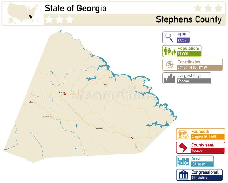
Free with trial Detailed infographic and map of Stephens County in Georgia. USA. Coordinates vectors Detailed infographic and map of Stephens County in Georgia. USA
Free with trial Detailed infographic and map of Tattnall County in Georgia. USA. Coordinates vectors Detailed infographic and map of Tattnall County in Georgia. USA
Free with trial Detailed infographic and map of Seminole County in Georgia. USA. Coordinates vectors Detailed infographic and map of Seminole County in Georgia. USA
Free with trial This image was created using Generative AI. A flat design icon featuring a central pink map pin with four arrows pointing in cardinal directions, representing navigation, guidance, and location services. Coordinates vectors Multicolor directional arrows around a pink location pin icon on a white background. This image was created using Generative AI. A flat design icon featuring a. This image was created using Generative AI. A flat design icon featuring a central pink map pin with four arrows pointing in cardinal directions, representing navigation, guidance, and location services
Free with trial This image was created using Generative AI. Minimalist black map with location pin icon and dashed route path. Ideal for navigation, travel, and GPS applications. Clean style for web and mobile. Coordinates vectors Black Map Location Pin Icon With Folded Paper Route Path Design Simple Minimalist. This image was created using Generative AI. Minimalist black map with location. This image was created using Generative AI. Minimalist black map with location pin icon and dashed route path. Ideal for navigation, travel, and GPS applications. Clean style for web and mobile
Free with trial This image was created using Generative AI. A simple black map pin icon on a white background representing location and navigation online. Coordinates vectors Black map pin icon on white background symbolizing location and navigation online. This image was created using Generative AI. A simple black map pin icon on a. This image was created using Generative AI. A simple black map pin icon on a white background representing location and navigation online
Free with trial This image was created using Generative AI. A minimalist black and white icon depicts a location marker hovering over a stylized land parcel, ideal for real estate apps, travel guides, and digital mapping interfaces. Coordinates vectors Map location pin icon placed above a generic land plot area for navigation design. This image was created using Generative AI. A minimalist black and white icon. This image was created using Generative AI. A minimalist black and white icon depicts a location marker hovering over a stylized land parcel, ideal for real estate apps, travel guides, and digital mapping interfaces
Free with trial This image was created using Generative AI. A minimalist white map pin symbol centered on a dark brown square backdrop representing GPS navigation, location tracking, destination marking, and digital mapping. Coordinates vectors White Location Pin Icon Set Against A Dark Brown Square Background For Navigation. This image was created using Generative AI. A minimalist white map pin symbol. This image was created using Generative AI. A minimalist white map pin symbol centered on a dark brown square backdrop representing GPS navigation, location tracking, destination marking, and digital mapping
 Sign in