Free with trial Political map of Europe in vector with present states borders. Gibraltar vectors Political map of Europe. In vector with present states borders
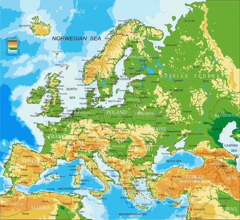
Free with trial Highly detailed physical map of Europe, in vector format, with all the relief forms, countries and big cities. Gibraltar vectors Europe - physical map. Highly detailed physical map of Europe, in vector format, with all the relief forms, countries and big cities. Highly detailed physical map of Europe, in vector format, with all the relief forms, countries and big cities.
Free with trial Europe Physical Map. Detailed illustration of Europe Physical Map. Gibraltar vectors Europe Physical Map. Detailed illustration of
Free with trial Passport stamps. Passsport stamps from China, Egypt, Japan, Gibraltar, Canada, Guadeloupe, Spain. Gibraltar vectors Passport stamps. Passsport stamps from China, Egypt, Japan, Gibraltar, Canada, Guadeloupe, Spain
Free with trial Spain Map. Map of Spain with national borders, most important cities, rivers and lakes. Gibraltar vectors Spain Map. Map of Spain with national borders, most important cities, rivers and lakes
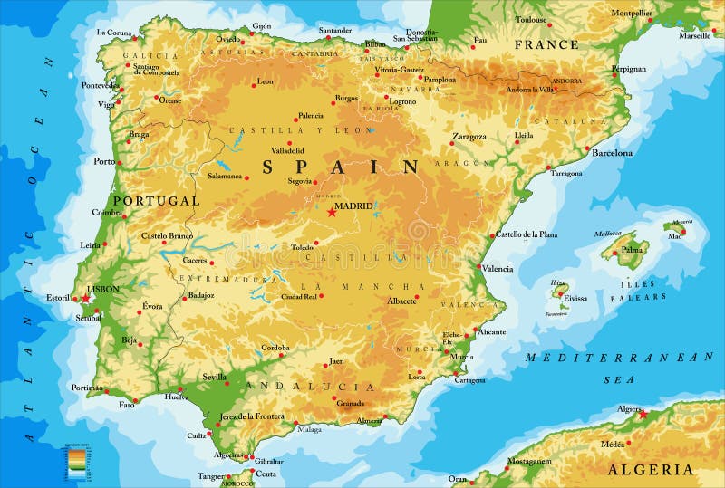
Free with trial Highly detailed physical map of Spain,in vector format,with all the relief forms,regions and big cities. Gibraltar vectors Spain physical map. Highly detailed physical map of Spain,in vector format,with all the relief forms,regions and big cities. Highly detailed physical map of Spain,in vector format,with all the relief forms,regions and big cities.
Free with trial Flags of Europe. Collection of Europe country flags in s. Gibraltar vectors Flags of Europe. Collection of Europe country flags in s
Free with trial Europe Physical Map. No text. Detailed illustration of Europe Physical Map. Gibraltar vectors Europe Physical Map. No text. Detailed illustration of Europe Physical Map
Free with trial Hand drawn map of Morocco and Western Sahara with the capitals Rabat and El Aiun, with national borders, most important cities, rivers and lakes. Vector illustration with english labeling and scale. Gibraltar vectors Morocco And Western Sahara Map. Hand drawn map of Morocco and Western Sahara with the capitals Rabat and El Aiun, with national borders, most important cities. Hand drawn map of Morocco and Western Sahara with the capitals Rabat and El Aiun, with national borders, most important cities, rivers and lakes. Vector illustration with english labeling and scale.
Free with trial Europe Physical Map. Retro Colors. Detailed illustration of Europe Physical Map. Gibraltar vectors Europe Physical Map. Retro Colors. Detailed illustration of Europe Physical Map
Free with trial Highly detailed physical map of Europe, in vector format, with all the relief forms, countries and big cities. Gibraltar vectors Europe - physical map. Highly detailed physical map of Europe, in vector format, with all the relief forms, countries and big cities. Highly detailed physical map of Europe, in vector format, with all the relief forms, countries and big cities.
Free with trial Map of Europe black - detailed - showing countries border. Gibraltar vectors Map of Europe Black. Detailed - showing countries border
Free with trial Spain map. Highly detailed vector map of Spain with administrative regions, main cities and roads. Gibraltar vectors Spain map. Highly detailed vector map of Spain with administrative regions, main cities and roads
Free with trial Political map of Algeria with the capital Algiers, national borders, most important cities, rivers and lakes. Vector illustration with english labeling and scale. Gibraltar vectors Algeria Political Map. Political map of Algeria with the capital Algiers, national borders, most important cities, rivers and lakes. Vector illustration with. Political map of Algeria with the capital Algiers, national borders, most important cities, rivers and lakes. Vector illustration with english labeling and scale.
Free with trial Europe Physical Map. No bathymetry. Detailed illustration of Europe Physical Map. Gibraltar vectors Europe Physical Map. No bathymetry. Detailed illustration of Europe Physical Map
Free with trial Map pointers with flags illustration. Europe. Gibraltar vectors Map pointers with flags. Europe. Map pointers with flags illustration. Europe. Map pointers with flags illustration. Europe.
Free with trial Gibraltar grunge rubber stamp. Blue grunge rubber stamp with the name of Gibraltar from the Iberian Peninsula written inside the stamp. Gibraltar vectors Gibraltar grunge rubber stamp. Blue grunge rubber stamp with the name of Gibraltar from the Iberian Peninsula written inside the stamp
Free with trial Highly detailed physical map of Spain,in vector format,with all the relief forms,regions and big cities. Gibraltar vectors Spain relief map. Highly detailed physical map of Spain,in vector format,with all the relief forms,regions and big cities. Highly detailed physical map of Spain,in vector format,with all the relief forms,regions and big cities.
Free with trial Illustration of the video game Apex Legends` logo along with its name. Gibraltar vectors Apex Legends Logo. Illustration of the video game Apex Legends` logo along with its name. Illustration of the video game Apex Legends` logo along with its name.
Free with trial Portugal and Spain political map with capitals Lisbon and Madrid, Balearic Islands and national borders. Gray illustration of Iberian Peninsula with English labeling and scaling on white background. Gibraltar vectors Portugal and Spain political map. With capitals Lisbon and Madrid, Balearic Islands and national borders. Gray illustration of Iberian Peninsula with English. Portugal and Spain political map with capitals Lisbon and Madrid, Balearic Islands and national borders. Gray illustration of Iberian Peninsula with English labeling and scaling on white background.
Free with trial Europe Physical Map. Retro Colors. No text. Detailed illustration of Europe Physical Map. Gibraltar vectors Europe Physical Map. Retro Colors. No text. Detailed illustration of Europe Physical Map
Free with trial Spain - hand drawn collection. Spain - collection of hand drawn illustration. Gibraltar vectors Spain - hand drawn collection. Spain - collection of hand drawn illustration
Free with trial Europe Physical Map Isolated on Retro White. No text. Detailed illustration of Europe Physical Map. Gibraltar vectors Europe Physical Map Isolated on Retro White. No text. Detailed illustration of Europe Physical Map
Free with trial Spain - hand drawn collection. Spain - collection of hand drawn illustrations. Gibraltar vectors Spain - hand drawn collection. Spain - collection of hand drawn illustrations
Free with trial Europe Physical Map. White and Gray. Detailed illustration of Europe Physical Map. Gibraltar vectors Europe Physical Map. White and Gray. Detailed illustration of Europe Physical Map
Free with trial Europe Physical Map. Retro Colors. No bathymetry. Detailed illustration of Europe Physical Map. Gibraltar vectors Europe Physical Map. Retro Colors. No bathymetry. Detailed illustration of Europe Physical Map
Free with trial Circle flags of the world, dependencies, provinces, islands, territories, disputed territories, regions, non recognized by UN, self proclaimed, collection, eps 10. Gibraltar vectors Circle flags of the world. Dependencies, provinces, islands, territories, disputed territories, regions, non recognized by UN, self proclaimed, collection, eps
Free with trial Blue map of Spain and the islands, with administrative divisions into autonomous communities and islands, vector illustration on a white background, for your design. Gibraltar vectors Blue map of Spain and the islands, with administrative divisions into autonomous communities and islands, vector illustration on a. White background, for your
Free with trial Square flags of Europe. From Albania to Wales. Vector Illustration. Gibraltar vectors Square flags of Europe. From Albania to Wales. Vector Illustration
Free with trial Gibraltar political map. British Overseas Territory on southern end of Iberian Peninsula. The Rock of Gibraltar shares its northern border with Spain. Gray illustration with English labeling. Vector. Gibraltar vectors Gibraltar political map. British Overseas Territory on southern end of Iberian Peninsula. The Rock of Gibraltar shares its northern border with Spain. Gray
Free with trial Gibraltar Political Map of the British Oversea Territory. English labeling and scaling. Illustration. Gibraltar vectors Gibraltar Political Map. Of the British Oversea Territory. English labeling and scaling. Illustration
Free with trial Strait of Gibraltar, political map. Also known as Straits of Gibraltar. Narrow strait, connecting the Atlantic Ocean to the Mediterranean Sea, separating the Iberian Peninsula from Morocco and Africa. Gibraltar vectors Strait of Gibraltar, also known as Straits of Gibraltar, political map. Strait of Gibraltar, political map. Also known as Straits of Gibraltar. Narrow strait. Strait of Gibraltar, political map. Also known as Straits of Gibraltar. Narrow strait, connecting the Atlantic Ocean to the Mediterranean Sea, separating the Iberian Peninsula from Morocco and Africa.
Free with trial Strait of Gibraltar, waterway between Spain and Morocco vector map. Gibraltar vectors Strait of Gibraltar, waterway between Spain and Morocco vector map.
Free with trial Rock of Gibraltar, Gibraltar, Europe, British fully editable vector icons. Gibraltar vectors Rock of Gibraltar, Gibraltar, Europe, British fully editable vector icons
Free with trial Gibraltar map vector. Illustration, scribble sketch Gibraltar. Gibraltar vectors Gibraltar map vector. Illustration, scribble sketch Gibraltar
Free with trial Green dollar and men mosaic map of Gibraltar and textured stamp. Stamp seal includes GIBRALTAR text between parallel lines. Mosaic map of Gibraltar constructed from green dollars, and men icons. Gibraltar vectors Textured Gibraltar Stamp Imitation and Green People and Dollar Mosaic Map of Gibraltar. Green dollar and men mosaic map of Gibraltar and textured stamp. Stamp. Green dollar and men mosaic map of Gibraltar and textured stamp. Stamp seal includes GIBRALTAR text between parallel lines. Mosaic map of Gibraltar constructed from green dollars, and men icons.
Free with trial Flag of Gibraltar. Vector Illustration. Gibraltar vectors Flag of Gibraltar. Vector Illustration
Free with trial Foreign language school concept. Lips, open mouth, flag of Gibraltar. Dependent territories in Europe. Part of the EU European Union. British overseas territory. Gibraltar vectors Flag of Gibraltar. Foreign language school concept. Lips, open mouth, flag of Gibraltar. Dependent territories in Europe. Part of the EU European Union. British. Foreign language school concept. Lips, open mouth, flag of Gibraltar. Dependent territories in Europe. Part of the EU European Union. British overseas territory.
Free with trial Map of Gibraltar. And their flag illustration. Gibraltar vectors Map of Gibraltar. And their flag illustration
Free with trial Map Gibraltar. Illustration Vector of a Map and Flag from Gibraltar. Gibraltar vectors Map Gibraltar. Illustration Vector of a Map and Flag from Gibraltar
Free with trial Gibraltar car license plate, letters, numbers and symbols, Europe. Gibraltar car license plate, letters, numbers and symbols, vector illustration, Europe. Gibraltar vectors Gibraltar car license plate, letters, numbers and symbols, Europe. Gibraltar car license plate, letters, numbers and symbols, vector illustration, Europe
Free with trial The flag of Gibraltar, white with a red stripe at the bottom, a three-towered red castle, in the middle tower hangs a gold key. Vector flat style illustration. Gibraltar vectors The Gibraltar national flag vector illustration. The flag of Gibraltar, white with a red stripe at the bottom, a three-towered red castle, in the middle tower. The flag of Gibraltar, white with a red stripe at the bottom, a three-towered red castle, in the middle tower hangs a gold key. Vector flat style illustration
Free with trial Gibraltar waving flag pattern background. Realistic national flag design. Abstract vector template. Gibraltar vectors Gibraltar waving flag pattern background. Realistic national flag design. Abstract vector template.
Free with trial Gibraltar flag on button. Signs and Symbols. Gibraltar vectors Gibraltar flag on button. Signs and Symbols
Free with trial Circle badge Gibraltar flag button vector illustration isolated. Europe state. Gibraltar national symbol. Patriotic roundel Gibraltar flag emblem banner. Gibraltar vectors Circle badge Gibraltar flag button vector illustration isolated. Europe state. Gibraltar national symbol. Patriotic roundel Gibraltar flag emblem banner
Free with trial Flag Map of Gibraltar. Vector Illustration of the Flag Incorporated Into the Map of Gibraltar. Gibraltar vectors Flag Map of Gibraltar. Vector Illustration of the Flag Incorporated Into the Map of Gibraltar
Free with trial Small 3d man holding a flag of Gibraltar. Illustration - small 3d man holding a flag of Gibraltar. Gibraltar vectors Small 3d man holding a flag of Gibraltar. Illustration - small 3d man holding a flag of Gibraltar
Free with trial Flag of Gibraltar. Vector illustration of the Flag of Gibraltar. Gibraltar vectors Flag of Gibraltar. Vector illustration of the Flag of Gibraltar
Free with trial Gibraltar waving flag. Gibraltar national flag background texture. Vector illustration. Gibraltar vectors Gibraltar waving flag. Gibraltar national flag background texture. Vector illustration
Free with trial Gibraltar Flag banner design - This Vector EPS 10 illustration is best for print media, web design, application design user interface and infographics with well composed layers for the ease of user. Gibraltar vectors Gibraltar Flag banner design. This Vector EPS 10 illustration is best for print media, web design, application design user interface and infographics with. Gibraltar Flag banner design - This Vector EPS 10 illustration is best for print media, web design, application design user interface and infographics with well composed layers for the ease of user.
Free with trial Gibraltar Map Flag. Map of Gibraltar with flag isolated on white background. British Overseas Territory. United Kingdom, UK. Vecto. R illustration. Gibraltar vectors Gibraltar Map Flag. Map of Gibraltar with flag isolated on white background. British Overseas Territory. United Kingdom, UK. Vecto. R illustration
Free with trial Gibraltar map with flag. Gibraltar Map Flag. Map of Gibraltar with flag isolated on white background. British Overseas Territory. United Kingdom, UK. Vector illustration. Gibraltar vectors Gibraltar map with flag. Gibraltar Map Flag. Map of Gibraltar with flag isolated on white background. British Overseas Territory. United Kingdom, UK. Vector
Free with trial Gibraltar vs Republic of Ireland icon for European football tournament qualification, group B. Competition icon on the stylized background. Gibraltar vectors Gibraltar vs Republic of Ireland icon for European football tournament qualification, group B. Competition icon on the stylized background
Free with trial Gibraltar map. Gibraltar is a British Overseas Territory located on the southern end of the Iberian Peninsula at the entrance of the Mediterranean. Gibraltar vectors Gibraltar map. Gibraltar is a British Overseas Territory located on the southern end of the Iberian Peninsula at the entrance of the Mediterranean
Free with trial National Television. Vintage TV and Flag of Gibraltar as Symbol National Television. Button with flag design. Gibraltar vectors National Television. Vintage TV and Flag of Gibraltar as Symbol National Television. Button with flag design
Free with trial Europe Micro States Waving Flag Set. The set includes the flags of Andorra, Luxembourg, San Marino, Malta, Vatican City, Monaco, Isle of Man, Liechtenstein and Gibraltar. Vector Icons neatly on Layers. Gibraltar vectors Europe Micro States Waving Flag Set. The set includes the flags of Andorra, Luxembourg, San Marino, Malta, Vatican City, Monaco, Isle of Man, Liechtenstein and
Free with trial Button. With map from Gibraltar - Vector. Gibraltar vectors Button. With map from Gibraltar - Vector
Free with trial Gibraltar. State flags and architecture of the country. Illustration on white background. Gibraltar vectors Gibraltar. State flags and architecture of the country. Illustration on white background
Free with trial Dependent territories in Europe, Akrotiri and Dhekelia, Faroe Islands, Gibraltar, Guernsey, Isle of Man, Jersey, silky waving vector realistic flags collection. Gibraltar vectors Dependent territories flag vector collection. Dependent territories in Europe, Akrotiri and Dhekelia, Faroe Islands, Gibraltar, Guernsey, Isle of Man, Jersey. Dependent territories in Europe, Akrotiri and Dhekelia, Faroe Islands, Gibraltar, Guernsey, Isle of Man, Jersey, silky waving vector realistic flags collection
Free with trial Collection of map pin with detailed map and neighboring countries, 9 map pins of Gambia, Georgia, Germany, Ghana, Gibraltar, Greece, Grenada, Guatemala, Guinea. Gibraltar vectors Collection of map pin with detailed map and neighboring countries. 9 map pins of Gambia, Georgia, Germany, Ghana, Gibraltar, Greece, Grenada, Guatemala, Guinea
Free with trial Vector logo for European football, soccer Scotland, Northern Ireland, Belgium, England, Wales, Gibraltar, Netherlands, Faroe Islands, Luxembourg, isolated: state flags, soccer balls. Championship Euro. Gibraltar vectors European football flags. Vector logo for European football, soccer Scotland, Northern Ireland, Belgium, England, Wales, Gibraltar, Netherlands, Faroe Islands. Vector logo for European football, soccer Scotland, Northern Ireland, Belgium, England, Wales, Gibraltar, Netherlands, Faroe Islands, Luxembourg, isolated: state flags, soccer balls. Championship Euro
Free with trial Spain, gray political map with capital Madrid. Kingdom of Spain. Country on the Iberian Peninsula, with the Balearic Islands, Canary Islands, and the exclaves Ceuta and Melilla. Illustration. Vector. Gibraltar vectors Spain, country on the Iberian Peninsula, gray political map. Spain, gray political map with capital Madrid. Kingdom of Spain. Country on the Iberian Peninsula. Spain, gray political map with capital Madrid. Kingdom of Spain. Country on the Iberian Peninsula, with the Balearic Islands, Canary Islands, and the exclaves Ceuta and Melilla. Illustration. Vector
Free with trial Portugal political map with capital Lisbon, national borders, most important cities, rivers and lakes. Illustration with English labeling and scaling. Vector. Gibraltar vectors Portugal Political Map. With capital Lisbon, national borders, most important cities, rivers and lakes. Illustration with English labeling and scaling. Vector
Free with trial Europe Physical Map. White and Gray. No text. Detailed illustration of Europe Physical Map. Gibraltar vectors Europe Physical Map. White and Gray. No text. Detailed illustration of Europe Physical Map
Free with trial Sailing boat felucca, little sailboat on the sea under the sail. Gibraltar vectors Sailing boat felucca. Little sailboat on the sea under the sail
Free with trial Morocco and Western Sahara political map with capitals Rabat and El Aiun and with national borders. Gray illustration with English labeling and scaling on white background. Gibraltar vectors Morocco and Western Sahara political map. With capitals Rabat and El Aiun and with national borders. Gray illustration with English labeling and scaling on
Free with trial World landmarks set. Set of the global landmarks and travel destinations. Gibraltar vectors World landmarks set. Set of the global landmarks and travel destinations
Free with trial Morocco map. Highly detailed vector map of Morocco with administrative regions,main cities and roads. Gibraltar vectors Morocco map. Highly detailed vector map of Morocco with administrative regions,main cities and roads
Free with trial Europe Physical Map Isolated on White. No text. Detailed illustration of Europe Physical Map. Gibraltar vectors Europe Physical Map Isolated on White. No text. Detailed illustration of Europe Physical Map
Free with trial Landmark Icon Bold Stroke with Color. On White Background. Vector Illustration. Gibraltar vectors Landmark Icon Bold Stroke with Color. On White Background. Vector Illustration
Free with trial Europe Physical Map Isolated on White. Detailed illustration of Europe Physical Map. Gibraltar vectors Europe Physical Map Isolated on White. Detailed illustration of Europe Physical Map
Free with trial Algeria map. Highly detailed vector map of Algeria with administrative regions, main cities and roads. Gibraltar vectors Algeria map. Highly detailed vector map of Algeria with administrative regions, main cities and roads
Free with trial Tangier grunge rubber stamp. Black grunge rubber stamp with the name of Tangier city from Morocco. Gibraltar vectors Tangier grunge rubber stamp. Black grunge rubber stamp with the name of Tangier city from Morocco
Free with trial Azores, Madeira, and Canary Islands, political map. Autonomous regions of Portugal and Spain, archipelagos of volcanic islands, in the Macaronesia region of North Atlantic ocean, next to North Africa. Gibraltar vectors Azores, Madeira, and Canary Islands, autonomous regions, political map. Azores, Madeira, and Canary Islands, political map. Autonomous regions of Portugal and. Azores, Madeira, and Canary Islands, political map. Autonomous regions of Portugal and Spain, archipelagos of volcanic islands, in the Macaronesia region of North Atlantic ocean, next to North Africa.
Free with trial The Mediterranean Sea subdivisions, political map with straits, countries and the Black Sea. Connected to the Atlantic Ocean, surrounded by the Mediterranean Basin, almost completely enclosed by land. Gibraltar vectors Mediterranean Sea subdivisions, political map, with the Black Sea. The Mediterranean Sea subdivisions, political map with straits, countries and the Black Sea. The Mediterranean Sea subdivisions, political map with straits, countries and the Black Sea. Connected to the Atlantic Ocean, surrounded by the Mediterranean Basin, almost completely enclosed by land.
Free with trial Morocco political map with capital Rabat and borders. Kingdom and Arab country in the Maghreb region of North Africa. Gray illustration on white background. English labeling. Vector. Gibraltar vectors Morocco political map. With capital Rabat and borders. Kingdom and Arab country in the Maghreb region of North Africa. Gray illustration on white background. Morocco political map with capital Rabat and borders. Kingdom and Arab country in the Maghreb region of North Africa. Gray illustration on white background. English labeling. Vector.
Free with trial Mediterranean Sea. Vector map of Mediterranean Sea with countries, big cities and icons. Gibraltar vectors Mediterranean Sea. Vector map of Mediterranean Sea with countries, big cities and icons
Free with trial The Mediterranean Sea, political map with subdivisions, straits, islands and countries. Connected to the Atlantic Ocean, surrounded by the Mediterranean Basin, almost completely enclosed by land. Gibraltar vectors The Mediterranean Sea, political map with subdivisions. Straits, islands and countries. Connected to the Atlantic Ocean, surrounded by the Mediterranean Basin. The Mediterranean Sea, political map with subdivisions, straits, islands and countries. Connected to the Atlantic Ocean, surrounded by the Mediterranean Basin, almost completely enclosed by land.
Free with trial Mediterranean Basin, political map with different colored countries. The Mediterranean Sea and region with the countries of South Europe, North Africa and the Near East. Isolated illustration. Vector. Gibraltar vectors Mediterranean Basin, political map with different colored countries. The Mediterranean Sea and region with the countries of South Europe, North Africa and the
Free with trial Road vector map of the autonomous community of andalusia, spain. Gibraltar vectors Road vector map of the autonomous community of andalusia, spain.
 Sign in