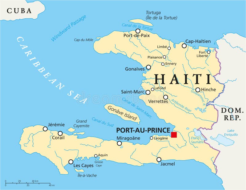
Free with trial Hispaniola Political Map with Haiti and Dominican Republic, located in the Caribbean island group, the Greater Antilles. With capitals, national borders, important cities, rivers and lakes. English labeling and scaling. Illustration. Ile vectors Hispaniola Political Map with Haiti and Dominican Republic. Located in the Caribbean island group, the Greater Antilles. With capitals, national borders. Hispaniola Political Map with Haiti and Dominican Republic, located in the Caribbean island group, the Greater Antilles. With capitals, national borders, important cities, rivers and lakes. English labeling and scaling. Illustration.
Free with trial Vector illustration of a woman over Ile de la cite and Ile saint Louis in Paris background (ink pen drawing). Ile vectors Woman nearby Ile de la cite in Paris. Vector illustration of a woman over Ile de la cite and Ile saint Louis in Paris background (ink pen drawing. Vector illustration of a woman over Ile de la cite and Ile saint Louis in Paris background (ink pen drawing)
Free with trial Tropical island at sunset. Silhouette of a tropical island at sunset, with waves and coconut trees. Ile vectors Tropical island at sunset. Silhouette of a tropical island at sunset, with waves and coconut trees
Free with trial Vector illustration of Paris- Ile de la Cite (hand drawing). Ile vectors Paris - Ile de la cite. Vector illustration of Paris- Ile de la Cite (hand drawing. Vector illustration of Paris- Ile de la Cite (hand drawing)
Free with trial French Regions. Twenty Two French Regions Icons in Blue. Ile vectors French Regions. Twenty Two French Regions Icons in Blue
Free with trial Map of France divided into regions. Map of France divided into twenty two regions. Ile vectors Map of France divided into regions. Map of France divided into twenty two regions
Free with trial France; Paris; Drawing of Notre Dame. Black and white detailed Drawing of Notre Dame cathedral in paris, france. Ile vectors France; Paris; Drawing of Notre Dame. Black and white detailed Drawing of Notre Dame cathedral in paris, france
Free with trial Paris - Place Dauphine. France - Paris - Place Dauphine illustration. Ile vectors Paris - Place Dauphine. France - Paris - Place Dauphine illustration
Free with trial France map, new regions. Ile vectors France map. New regions. France map, new regions
Free with trial Drawing of a view of Alexander III bridge in Paris showing Eiffel tower. Nightfall on a rainy autumn-winter day - Vector illustration. Ile vectors Drawing of Alexander III bridge in Paris showing Eiffel tower. Drawing of a view of Alexander III bridge in Paris showing Eiffel tower. Nightfall on a rainy. Drawing of a view of Alexander III bridge in Paris showing Eiffel tower. Nightfall on a rainy autumn-winter day - Vector illustration.
Free with trial Set of county maps of USA states Virginia,Washington,West Virginia,Wisconsin,Wyoming. Ile vectors Maps counties USA states. Set of county maps of USA states Virginia,Washington,West Virginia,Wisconsin,Wyoming. Set of county maps of USA states Virginia,Washington,West Virginia,Wisconsin,Wyoming.
Free with trial Vector illustration of Paris- Ile de la Cite - facades along the seine river (hand drawing). Ile vectors Paris - Ile de la cite. Vector illustration of Paris- Ile de la Cite - facades along the seine river (hand drawing. Vector illustration of Paris- Ile de la Cite - facades along the seine river (hand drawing)
Free with trial Ile Saint Louis in Paris. Vector illustration of Ile Saint Louis in Paris. Ile vectors Ile Saint Louis in Paris. Vector illustration of Ile Saint Louis in Paris
Free with trial Ile Saint Louis in Paris. Vector illustration of Ile Saint Louis in Paris. Ile vectors Ile Saint Louis in Paris. Vector illustration of Ile Saint Louis in Paris
Free with trial Vector illustration of Paris- Ile de la Cite - Pont neuf (hand drawing). Ile vectors Paris - Ile de la cite - Pont neuf. Vector illustration of Paris- Ile de la Cite - Pont neuf (hand drawing. Vector illustration of Paris- Ile de la Cite - Pont neuf (hand drawing)
Free with trial Vector illustration of Paris- Seine River with barges - Ile de la Cite and Notre-Dame (hand drawing). Ile vectors Paris - Ile de la cite - barges. Vector illustration of Paris- Seine River with barges - Ile de la Cite and Notre-Dame (hand drawing. Vector illustration of Paris- Seine River with barges - Ile de la Cite and Notre-Dame (hand drawing)
Free with trial Imaginary square in Paris. Vector illustration of an imaginary square in Paris. Ile vectors Imaginary square in Paris. Vector illustration of an imaginary square in Paris
Free with trial Place Dauphine illustration. France - Paris - Place Dauphine illustration. Ile vectors Place Dauphine illustration. France - Paris - Place Dauphine illustration
Free with trial Paris - view from Pont Neuf bridge. Vector illustration of a view from Pont Neuf bridge in Paris. Ile vectors Paris - view from Pont Neuf bridge. Vector illustration of a view from Pont Neuf bridge in Paris
Free with trial Vector black and white hand drawing. Bridge across river Seine Pont Louis Philippe near the Ile de la Cite in the winter morning, Pantheon in the background, Paris, France. Ile vectors Paris in the winter morning, France. Vector black and white hand drawing. Bridge across river Seine Pont Louis Philippe near the Ile de la Cite in the winter. Vector black and white hand drawing. Bridge across river Seine Pont Louis Philippe near the Ile de la Cite in the winter morning, Pantheon in the background, Paris, France.
Free with trial Arrondissements of Paris, capital of France, multi colored political map. Twenty municipal arrondissements of Paris spiral clockwise outwards, like a snail shell, starting from the middle of the city. Ile vectors Arrondissements of Paris, capital of France, colored political map. Arrondissements of Paris, capital of France, multi colored political map. Twenty municipal. Arrondissements of Paris, capital of France, multi colored political map. Twenty municipal arrondissements of Paris spiral clockwise outwards, like a snail shell, starting from the middle of the city.
Free with trial Sheep breeds collection 9. Farm animals set. Flat design. Vector illustration. Ile vectors Sheep breeds collection 9. Farm animals set. Flat design. Vector illustration
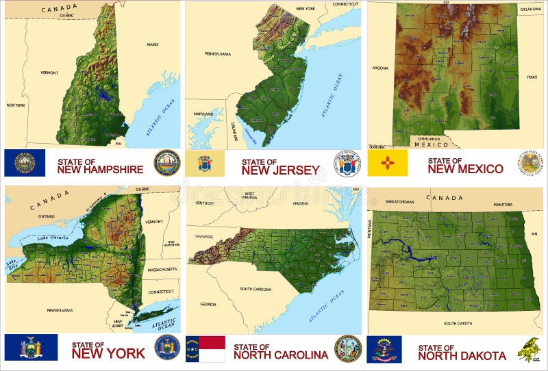
Free with trial Set of county maps of USA states New Hampshire,New Jersey, New Mexico,New York,North Carolina,North Dakota. Ile vectors Maps counties USA states. Set of county maps of USA states New Hampshire,New Jersey, New Mexico,New York,North Carolina,North Dakota. Set of county maps of USA states New Hampshire,New Jersey, New Mexico,New York,North Carolina,North Dakota.
Free with trial Quarter Little France. Strasbourg. France. Hand drawn old city sketch. Vector illustration. Ile vectors Quarter Little France. Strasbourg. France. Hand drawn sketch. Vector illustration. Quarter Little France. Strasbourg. France. Hand drawn old city sketch. Vector. Quarter Little France. Strasbourg. France. Hand drawn old city sketch. Vector illustration.
Free with trial Ile de la cite - illustration. Daylight view of the ile de la Cite from le pont neuf - Vector illustration. Ile vectors Ile de la cite - illustration. Daylight view of the ile de la Cite from le pont neuf - Vector illustration
Free with trial Vector illustration of Paris- Ile de la Cite - Palais de justice (hand drawing). Ile vectors Paris - Ile de la cite. Vector illustration of Paris- Ile de la Cite - Palais de justice (hand drawing. Vector illustration of Paris- Ile de la Cite - Palais de justice (hand drawing)
Free with trial Vector illustration of Paris- Seine River with barges - Ile de la Cite and Notre-Dame (hand drawing). Ile vectors Paris - Ile de la cite - barges. Vector illustration of Paris- Seine River with barges - Ile de la Cite and Notre-Dame (hand drawing. Vector illustration of Paris- Seine River with barges - Ile de la Cite and Notre-Dame (hand drawing)
Free with trial Ile Saint Louis in Paris, France - vector illustration Ideal for printing on fabric or paper, poster or wallpaper, house decoration. Ile vectors Ile Saint Louis in Paris, France. Vector illustration Ideal for printing on fabric or paper, poster or wallpaper, house decoration
Free with trial View of Ile Saint Louis in Paris. Vector illustration - view of Ile Saint Louis in Paris. Ile vectors View of Ile Saint Louis in Paris. Vector illustration - view of Ile Saint Louis in Paris
Free with trial New ile de france administrative and political vector map. Ile vectors New ile de france administrative and political vector map.
Free with trial Isoleucine. Ile C6H13NO2. α-Amino Acid. Structural Chemical Formula and Molecule 3d Model. Atoms with Color Coding. Vector. Illustration. Ile vectors Isoleucine. Ile C6H13NO2. α-Amino Acid. Structural Chemical Formula and Molecule 3d Model. Atoms with Color Coding. Vector. Illustration
Free with trial Ile de france region administrative and political vector map. Ile vectors Ile de france region administrative and political vector map.
Free with trial Detailed administrative map of the Ile-de-France region, France. Ile vectors Detailed administrative map of the Ile-de-France region, France.
Free with trial Map of Ile a Vache Island, Haiti, contains geography outlines for land mass, water, major roads and minor roads. Ile vectors Map of Ile a Vache Island. Haiti, contains geography outlines for land mass, water, major roads and minor roads
Free with trial Ile-de-France administrative map. Divided in departments with labels, France. Ile vectors Ile-de-France administrative map. Divided in departments with labels, France
Free with trial Ile-de-France silhouette map. Ile-de-France dark silhouette map isolated on white background, France. Ile vectors Ile-de-France silhouette map. Ile-de-France dark silhouette map isolated on white background, France
Free with trial Belle Ile map. Island silhouette icon. Isolated Belle Ile black map outline. Vector illustration. Ile vectors Belle Ile map. Island silhouette icon. Isolated Belle Ile black map outline. Vector illustration
Free with trial Isoleucine L- isoleucine , Ile, I amino acid molecule. It is used in the biosynthesis of proteins. Structural chemical formula and molecule model. Vector illustration. Ile vectors Isoleucine L- isoleucine , Ile, I amino acid molecule. It is used in the biosynthesis of proteins. Structural chemical formula. And molecule model. Vector
Free with trial Mahe island Republic of Seychelles, Indian Ocean, Inner Islands map vector illustration, scribble sketch Ile Mahé, Les Mamelles map,. Ile vectors Mahe island Republic of Seychelles, Indian Ocean, Inner Islands map vector illustration, scribble sketch Ile Mahé, Les Mamelles. Map
Free with trial Praslin island Republic of Seychelles, Indian Ocean, Inner Islands map vector illustration, scribble sketch Ile de Palmes and Cousine map,. Ile vectors Praslin island Republic of Seychelles, Indian Ocean, Inner Islands map vector illustration, scribble sketch Ile de Palmes and. Cousine map
Free with trial Ile de france administrative and political vector map with flag. Ile vectors Ile de france administrative and political vector map with flag.
Free with trial Flag of Ile-de-France also known as the region parisienne is one of the 18 regions of France, and includes the city of Paris. Vector illustration. Ile vectors Flag of Ile-de-France, France. Flag of Ile-de-France also known as the region parisienne is one of the 18 regions of France, and includes the city of Paris. Flag of Ile-de-France also known as the region parisienne is one of the 18 regions of France, and includes the city of Paris. Vector illustration
Free with trial Illustration of the basilica Notre Dame. Notre Dame de Paris - in English Our Lady of Paris, also known as Notre Dame Cathedral, is a Gothic, Catholic cathedral on the eastern half of the Ile de la Cite in the fourth arrondissement of Paris, France. Ile vectors Basilica Notre Dame in Paris - vector illustration. Illustration of the basilica Notre Dame. Notre Dame de Paris - in English Our Lady of Paris, also known as. Illustration of the basilica Notre Dame. Notre Dame de Paris - in English Our Lady of Paris, also known as Notre Dame Cathedral, is a Gothic, Catholic cathedral on the eastern half of the Ile de la Cite in the fourth arrondissement of Paris, France.
Free with trial Ile-de-France, departments and prefectures of the Paris Region, multi colored political map. Most populous region of France, centered on the capital Paris, located in the countries north-central part. Ile vectors Ile-de-France, departments and prefectures of Paris Region, colored map. Ile-de-France, departments and prefectures of the Paris Region, multi colored political. Ile-de-France, departments and prefectures of the Paris Region, multi colored political map. Most populous region of France, centered on the capital Paris, located in the countries north-central part.
Free with trial France, Paris, Ile De France. City skyline architecture, buildings, streets, silhouette, landscape, panorama landmarks Editable strokes Flat design line vector illustration Isolated icons. Ile vectors France, Paris, Ile De France . City skyline architecture. Buildings, streets, silhouette, landscape, panorama landmarks Editable strokes Flat design line. France, Paris, Ile De France . City skyline architecture, buildings, streets, silhouette, landscape, panorama landmarks Editable strokes Flat design line vector illustration Isolated icons
Free with trial Nosy Be and Nosy Komba island Republic of Madagascar map vector illustration, scribble sketch Ile Nossi-be, Assada or Nosse Be map,. Ile vectors Nosy Be and Nosy Komba island Republic of Madagascar map vector illustration, scribble sketch Ile Nossi-be, Assada or Nosse Be. Map
Free with trial Flag of L`Hay-les-Roses is a commune in the southern suburbs of Paris, France. Vector illustration. Ile vectors Flag of L`Hay-les-Roses in Val-de-Marne in Ile-de-France, France. Flag of L`Hay-les-Roses is a commune in the southern suburbs of Paris, France. Vector. Flag of L`Hay-les-Roses is a commune in the southern suburbs of Paris, France. Vector illustration
Free with trial Location of Ile-de-France on map France. 3d location sign similar to the flag of Ile-de-France. Quality map with regions of French Republic for your design. EPS10. Ile vectors Location of Ile-de-France on map France. 3d location sign similar to the flag of Ile-de-France. Quality map with regions of Fre. Nch Republic for your design
Free with trial Vector representation of a woman nearby Notre Dame in Paris (hand drawing). Ile vectors Woman nearby Notre Dame in Paris. Vector representation of a woman nearby Notre Dame in Paris (hand drawing. Vector representation of a woman nearby Notre Dame in Paris (hand drawing)
Free with trial Belle ile en mer. Illustration of a sailing boat. Ile vectors Belle ile en mer. Illustration of a sailing boat
Free with trial Clairefontaine en Yvelines city entrance road sign. Vector illustration of the Clairefontaine en Yvelines city entrance road sign on metallic post. Ile vectors Clairefontaine en Yvelines city entrance road sign. Vector illustration of the Clairefontaine en Yvelines city entrance road sign on metallic post
Free with trial Eiffel Tower Paris-France. Gold design vector background. Ile vectors Eiffel Tower Paris-France. Gold design vector background
Free with trial Statue of Liberty in Paris. Vector illustration of Statue of Liberty in Paris smaller sister of famous New York statue. Ile vectors Statue of Liberty in Paris. Vector illustration of Statue of Liberty in Paris smaller sister of famous New York statue
Free with trial Statue of Liberty in Paris. Vector illustration of Statue of Liberty in Paris and Eiffel tower against blue sky with white clouds. Ile vectors Statue of Liberty in Paris. Vector illustration of Statue of Liberty in Paris and Eiffel tower against blue sky with white clouds
Free with trial Arrondissements of Paris, capital of France, Europe, political map. Paris is divided into 20 municipal arrondissements. They spiral outwards clockwise, starting with Louvre, the first arrondissement. Ile vectors Arrondissements of Paris, capital of France, Europe, political map. Paris is divided into 20 municipal arrondissements. They spiral outwards clockwise
Free with trial Haiti Political Map with capital Port-au-Prince, with national borders, important cities, rivers and lakes. English labeling and scaling. Illustration. Ile vectors Haiti Political Map. With capital Port-au-Prince, with national borders, important cities, rivers and lakes. English labeling and scaling. Illustration
Free with trial Saint-Louis island on a bright summer day in Paris - Vector illustration. Ile vectors Saint-Louis island on a bright summer day in Paris. Vector illustration
Free with trial France map, new regions. Ile vectors France map. New regions. France map, new regions
Free with trial Mascarene Islands, political map. Mauritius, Reunion and Rodrigues. Mascarenhas Archipelago, a group of islands in the Indian Ocean. English labeling. Gray illustration on white background. Vector. Ile vectors Mascarene Islands, gray map, Mauritius, Reunion, Rodrigues. Mascarene Islands, political map. Mauritius, Reunion and Rodrigues. Mascarenhas Archipelago, a group. Mascarene Islands, political map. Mauritius, Reunion and Rodrigues. Mascarenhas Archipelago, a group of islands in the Indian Ocean. English labeling. Gray illustration on white background. Vector.
Free with trial Reunion political map with capital Saint-Denis. Island. Overseas department of France in the Indian Ocean, east of Madagascar. Gray illustration isolated on white background. English labeling. Vector. Ile vectors Reunion political map. With capital Saint-Denis. Island. Overseas department of France in the Indian Ocean, east of Madagascar. Gray illustration isolated on. Reunion political map with capital Saint-Denis. Island. Overseas department of France in the Indian Ocean, east of Madagascar. Gray illustration isolated on white background. English labeling. Vector.
Free with trial France, political map with multicolored regions of Metropolitan France. French Republic, capital Paris, administrative regions and prefectures on the mainland of Europe. English. Illustration. Vector. Ile vectors France, political map with multicolored regions of Metropolitan France. French Republic, capital Paris, administrative regions and prefectures on the mainland
Free with trial Mascarene Islands political map with capitals, consisting of Mauritius, Reunion and Rodrigues. Mascarenhas Archipelago, a group of islands in the Indian Ocean. English labeling. Illustration. Vector. Ile vectors Mascarene Islands political map, Mauritius, Reunion and Rodrigues. Mascarene Islands political map with capitals, consisting of Mauritius, Reunion and Rodrigues. Mascarene Islands political map with capitals, consisting of Mauritius, Reunion and Rodrigues. Mascarenhas Archipelago, a group of islands in the Indian Ocean. English labeling. Illustration. Vector.
Free with trial Original ink drawing of Pont Neuf in Paris- vector illustration (Ideal for printing, poster or wallpaper, house decoration. Ile vectors Original ink drawing of Pont Neuf in Paris. Vector illustration (Ideal for printing, poster or wallpaper, house decoration
Free with trial French Polynesia highly detailed physical map. Highly detailed physical map of French Polynesia in vector format,with all the relief forms,regions and big cities. Ile vectors French Polynesia highly detailed physical map. Highly detailed physical map of French Polynesia in vector format,with all the relief forms,regions and big cities
Free with trial Dıscos'e toucan. Graphic on a white background with three colorful parrots Daha iyi bir çeviri ile katkıda bulunun. Ile vectors Dıscos'e toucan. Graphic on a white background with three colorful parrots Daha iyi bir çeviri ile katkıda bulunun
Free with trial France Europe regions map vector EPS10 illustrationn Alsace Champagne-Ardenne. Lorraine. Aquitaine. Limousin. Poitou-Charentes. Auvergne. Rhône-Alpes. Normandy. Bourgogne. Comté. Brittany. Ile-de-France. Occitanie. Provence Alps. Ile vectors France Europe regions map.vector.EPS10.illustration. France Europe regions map vector EPS10 illustrationn Alsace Champagne-Ardenne.Lorraine.Aquitaine.Limousin. France Europe regions map vector EPS10 illustrationn Alsace Champagne-Ardenne.Lorraine.Aquitaine.Limousin.Poitou-Charentes.Auvergne.Rhône-Alpes.Normandy.Bourgogne.Comté.Brittany.Ile-de-France.Occitanie.Provence Alps.
Free with trial Road map of the region Centre Val de Loire, france. Ile vectors Road map of the region Centre Val de Loire. France
Free with trial Decorative alphabet with brown letters. Ile vectors Decorative alphabet. Decorative alphabet with brown letters. Decorative alphabet with brown letters.
Free with trial Metropolis of Greater Paris administrative and political vector map. Ile vectors Metropolis of Greater Paris administrative and political vector map.
Free with trial Long aged bridgework, Ile de la Cite, transport road and foot traffic way. Freehand outline ink hand drawn backdrop sketchy in art doodle retro style pen on paper. Panoramic view with space for text on sky. Ile vectors Bridge. Vector drawing. Long aged bridgework, Ile de la Cite, transport road and foot traffic way. Freehand outline ink hand drawn backdrop sketchy in art doodle. Long aged bridgework, Ile de la Cite, transport road and foot traffic way. Freehand outline ink hand drawn backdrop sketchy in art doodle retro style pen on paper. Panoramic view with space for text on sky
Free with trial Banner ribbon ocean blue graphic. Vector illustration eps 10. Ile vectors Banner ribbon ocean blue graphic. Vector illustration eps 10
Free with trial Drapeau et banniere vecteur des regions de France Bretagne. Drapeau et banniere des regions de France en vecteur. Bretagne. Ile vectors Drapeau et banniere vecteur des regions de France Bretagne. Drapeau et banniere des regions de France en vecteur. Bretagne
Free with trial Banner ribbon ocean blue graphic. Vector illustration eps 10. Ile vectors Banner ribbon ocean blue graphic. Vector illustration eps 10
Free with trial Flag of Île de France. Vector format ai available blu and yellow Florentine lily. Ile vectors Flag of Île de France. Vector format ai available blu and yellow Florentine lily
Free with trial Vector map of France with regions with flags and location on world map. Ile vectors Map of France. Vector map of France with regions with flags and location on world map. Vector map of France with regions with flags and location on world map.
Free with trial Administrative regions and departments of France vector map. S isolated illustrations. Ile vectors Administrative regions and departments of France vector map. S isolated illustrations
Free with trial Flag of Paris, France. Flag of Paris is the capital and most populous city of France. Vector illustration. Ile vectors Flag of Paris, France. Flag of Paris is the capital and most populous city of France. Vector illustration
Free with trial Flag of Antony is a subprefecture of the Hauts-de-Seine department and the seat of the arrondissement of Antony, France. Vector illustration. Ile vectors Flag of Antony in Hauts-de-Seine, France. Flag of Antony is a subprefecture of the Hauts-de-Seine department and the seat of the arrondissement of Antony, France. Flag of Antony is a subprefecture of the Hauts-de-Seine department and the seat of the arrondissement of Antony, France. Vector illustration
Free with trial Vector illustration of France metropolitan map with new regions and new names (july 2016). Ile vectors France metropolitan map with new regions. Vector illustration of France metropolitan map with new regions and new names (july 2016. Vector illustration of France metropolitan map with new regions and new names (july 2016)
Free with trial Detailed vector map of regions of France with flag. File for your design. Ile vectors Detailed vector map of regions of France with flag. File for your design
 Sign in