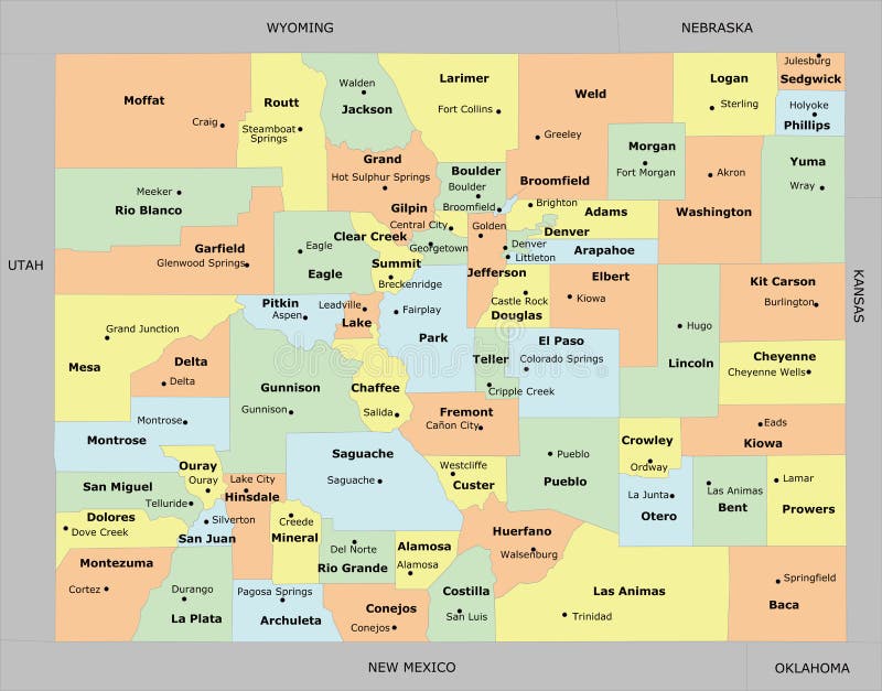
Free with trial Colorado county map. With 64 counties, county seats, and neighboring states/country. Each county and neighboring states/country is an individual object. Kiowa vectors Colorado county map. With 64 counties, county seats, and neighboring states/country. Each county and neighboring states/country is an individual object
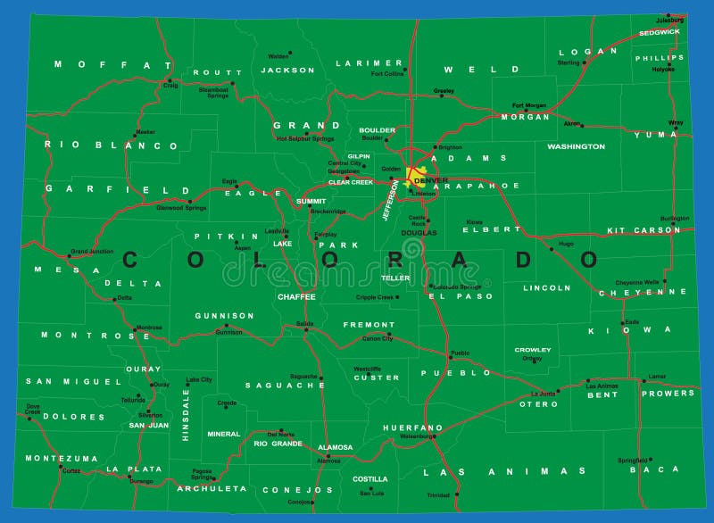
Free with trial Highly detailed vector map of Colorado,with counties,main cities and roads. Kiowa vectors State of Colorado political map. Highly detailed vector map of Colorado,with counties,main cities and roads. Highly detailed vector map of Colorado,with counties,main cities and roads.
Free with trial Antique portrait of Kicking Bird, High Chief of the Kiowa. In frontal view. Kiowa vectors Antique portrait of Kicking Bird, High Chief of the Kiowa. In frontal view
Free with trial Military Air Forces Icon. Military air forces isometric icon with bell oh58 kiowa helicopter 3d vector illustration. Kiowa vectors Military Air Forces Icon. Military air forces isometric icon with bell oh58 kiowa helicopter 3d vector illustration
Free with trial Bell OH-58 Kiowa. Vector drawing of reconnaissance helicopter. Side view. Image for illustration and infographics. Kiowa vectors Bell OH-58 Kiowa. Vector drawing of reconnaissance helicopter. Vector drawing of reconnaissance helicopter. Side view. Image for illustration and infographics
Free with trial Lake Kiowa City Map, Texas, USA. Modern flat vector map of Lake Kiowa, Texas, United States. Detailed city boundary silhouette in grey on a white background. Kiowa vectors Lake Kiowa City Map, Texas, USA. Modern flat vector map of Lake Kiowa, Texas, United States. Detailed city boundary silhouette in grey on a white background
Free with trial Map of the County Kiowa (Kansas, United States). Symbol Map of the County Kiowa (Kansas, US) showing the County with a few black horizontal lines. Kiowa vectors Map of the County Kiowa (Kansas, United States). Symbol Map of the County Kiowa (Kansas, US) showing the County with a few black horizontal lines
Free with trial Map of the County Kiowa (Oklahoma, United States). Symbol Map of the County Kiowa (Oklahoma, US) showing the County with a few black horizontal lines. Kiowa vectors Map of the County Kiowa (Oklahoma, United States). Symbol Map of the County Kiowa (Oklahoma, US) showing the County with a few black horizontal lines
Free with trial Map of the County Kiowa (Colorado, United States). Symbol Map Of the County Kiowa (Colorado, US) showing the County with a few black dots. Kiowa vectors Map of the County Kiowa (Colorado, United States). Symbol Map Of the County Kiowa (Colorado, US) showing the County with a few black dots
Free with trial Kiowa outline map. Kiowa County (Colorado) blank outline map. Kiowa vectors Kiowa outline map. Kiowa County (Colorado) blank outline map. Kiowa County (Colorado) blank outline map
Free with trial Kiowa outline map. Kiowa County (Kansas) blank outline map. Kiowa vectors Kiowa outline map. Kiowa County (Kansas) blank outline map. Kiowa County (Kansas) blank outline map
Free with trial Kiowa outline map. Kiowa County (Kansas) outline map set. Kiowa vectors Kiowa outline map. Kiowa County (Kansas) outline map set. Kiowa County (Kansas) outline map set
Free with trial Map of the County Kiowa (Colorado, United States). Symbol Map Of the County Kiowa (Colorado, US) showing the County with a few black dots. Kiowa vectors Map of the County Kiowa (Colorado, United States). Symbol Map Of the County Kiowa (Colorado, US) showing the County with a few black dots
Free with trial Kiowa outline map. Kiowa County (Oklahoma) blank outline map. Kiowa vectors Kiowa outline map. Kiowa County (Oklahoma) blank outline map. Kiowa County (Oklahoma) blank outline map
Free with trial Map of the County Kiowa (Colorado, United States). Symbol Map of the County Kiowa (Colorado, US) showing the County with a few black horizontal lines. Kiowa vectors Map of the County Kiowa (Colorado, United States). Symbol Map of the County Kiowa (Colorado, US) showing the County with a few black horizontal lines
Free with trial Colorado counties, political map with borders and county names. State in the Mountain West subregion of the United States, subdivided into 64 counties. Nicknamed The Centennial State. Illustration. Kiowa vectors Colorado, U.S. state subdivided into 46 counties, political map. Colorado counties, political map with borders and county names. State in the Mountain West. Colorado counties, political map with borders and county names. State in the Mountain West subregion of the United States, subdivided into 64 counties. Nicknamed The Centennial State. Illustration
Free with trial Portrait of historic Native American Kiowa chief Big Tree in frontal view, holding bow and arrow. Kiowa vectors Portrait of historic Native American Kiowa chief Big Tree in frontal view. Holding bow and arrow
Free with trial Map of Kiowa in Kansas. Detailed and accurate illustration of map of Kiowa in Kansas. Kiowa vectors Map of Kiowa in Kansas. Detailed and accurate illustration of map of Kiowa in Kansas
Free with trial Map of Kiowa in Kansas. Detailed and accurate illustration of map of Kiowa in Kansas. Kiowa vectors Map of Kiowa in Kansas. Detailed and accurate illustration of map of Kiowa in Kansas
Free with trial Map of Kiowa in Kansas. Detailed and accurate illustration of map of Kiowa in Kansas. Kiowa vectors Map of Kiowa in Kansas. Detailed and accurate illustration of map of Kiowa in Kansas
Free with trial Map of Kiowa in Oklahoma. Detailed and accurate illustration of map of Kiowa in Oklahoma. Kiowa vectors Map of Kiowa in Oklahoma. Detailed and accurate illustration of map of Kiowa in Oklahoma
Free with trial Map of Kiowa County in Colorado USA. Large and detailed map of Kiowa County in Colorado USA. Kiowa vectors Map of Kiowa County in Colorado USA. Large and detailed map of Kiowa County in Colorado USA
Free with trial Map of Kiowa County in Colorado, USA. Large and detailed map of Kiowa County in Colorado, USA. Kiowa vectors Map of Kiowa County in Colorado, USA. Large and detailed map of Kiowa County in Colorado, USA
Free with trial Kiowa outline map. Kiowa County (Colorado) outline map set. Kiowa vectors Kiowa outline map. Kiowa County (Colorado) outline map set. Kiowa County (Colorado) outline map set
Free with trial Kiowa outline map. Kiowa County (Oklahoma) outline map set. Kiowa vectors Kiowa outline map. Kiowa County (Oklahoma) outline map set. Kiowa County (Oklahoma) outline map set
Free with trial Map of Kiowa County in Colorado USA. Detailed infographic and map of Kiowa County in Colorado USA. Kiowa vectors Map of Kiowa County in Colorado USA. Detailed infographic and map of Kiowa County in Colorado USA
Free with trial Map of Kiowa in Oklahoma. Detailed and accurate illustration of map of Kiowa in Oklahoma. Kiowa vectors Map of Kiowa in Oklahoma. Detailed and accurate illustration of map of Kiowa in Oklahoma
Free with trial Map of Kiowa in Oklahoma. Detailed and accurate illustration of map of Kiowa in Oklahoma. Kiowa vectors Map of Kiowa in Oklahoma. Detailed and accurate illustration of map of Kiowa in Oklahoma
Free with trial Map of Kiowa in Colorado. Detailed and accurate illustration of map of Kiowa in Colorado. Kiowa vectors Map of Kiowa in Colorado. Detailed and accurate illustration of map of Kiowa in Colorado
Free with trial Map of Kiowa in Colorado. Detailed and accurate illustration of map of Kiowa in Colorado. Kiowa vectors Map of Kiowa in Colorado. Detailed and accurate illustration of map of Kiowa in Colorado
Free with trial Map of Kiowa in Colorado. Detailed and accurate illustration of map of Kiowa in Colorado. Kiowa vectors Map of Kiowa in Colorado. Detailed and accurate illustration of map of Kiowa in Colorado
Free with trial Map of Kiowa County in Colorado, USA. Map of Kiowa County in Colorado, USA arranged in a circle. Kiowa vectors Map of Kiowa County in Colorado, USA. Map of Kiowa County in Colorado, USA arranged in a circle
Free with trial Large and detailed map of Kiowa county in Colorado, USA. Kiowa vectors Map of Kiowa County in Colorado. Large and detailed map of Kiowa county in Colorado, USA. Large and detailed map of Kiowa county in Colorado, USA.
Free with trial Large and detailed map of Kiowa county in Colorado, USA. Kiowa vectors Map of Kiowa County in Colorado. Large and detailed map of Kiowa county in Colorado, USA. Large and detailed map of Kiowa county in Colorado, USA.
Free with trial Kearny, Kingman, Jackson, Kiowa, Harper and Jewell County, Kansas U. S. county, United States of America, USA, U. , US map vector illustration, scribble sketch map,. Kiowa vectors Kearny, Kingman, Jackson, Kiowa, Harper and Jewell County, Kansas U.S. county, United States of America, USA, U.S., US map. Vector illustration, scribble sketch
Free with trial Kearny, Kingman, Jackson, Kiowa, Harper and Jewell County, Kansas U. S. county, United States of America map vector illustration, scribble sketch map. Kiowa vectors Kearny, Kingman, Jackson, Kiowa, Harper and Jewell County, Kansas U.S. county, United States of America, USA, U.S., US map. Kearny, Kingman, Jackson, Kiowa. Kearny, Kingman, Jackson, Kiowa, Harper and Jewell County, Kansas U.S. county, United States of America map vector illustration, scribble sketch map
Free with trial Kiowa County, Oklahoma State U. S. county, United States of America, USA, U. , US map vector illustration, scribble sketch Kiowa map,. Kiowa vectors Kiowa County, Oklahoma State U.S. county, United States of America, USA, U.S., US map vector illustration, scribble sketch Kiowa. Map
Free with trial Map on an old playing card of Kiowa county in Colorado, USA. Kiowa vectors Map of Kiowa County in Colorado. Map on an old playing card of Kiowa county in Colorado, USA. Map on an old playing card of Kiowa county in Colorado, USA.
Free with trial Large and detailed map of Kiowa county in Colorado, USA. Kiowa vectors Map of Kiowa County in Colorado. Large and detailed map of Kiowa county in Colorado, USA. Large and detailed map of Kiowa county in Colorado, USA.
Free with trial Kiowa and Logan County, Colorado U. S. county, United States of America,USA, U. , US map vector illustration, scribble sketch Kiowa and Logan map,. Kiowa vectors Kiowa and Logan County, Colorado U.S. county, United States of America,USA, U.S., US map vector illustration, scribble sketch. Kiowa and Logan map
Free with trial Kiowa County, Oklahoma State U. S. county, United States of America, USA, U. , US map vector illustration, scribble sketch Kiowa map,. Kiowa vectors Kiowa County, Oklahoma State U.S. county, United States of America, USA, U.S., US map vector illustration, scribble sketch Kiowa. Map
Free with trial Kiowa County, Oklahoma State U. S. county, United States of America, USA, U. , US map vector illustration, scribble sketch Kiowa map,. Kiowa vectors Kiowa County, Oklahoma State U.S. county, United States of America, USA, U.S., US map vector illustration, scribble sketch Kiowa. Map
Free with trial Kiowa and Logan County, Colorado U. S. county, United States of America,USA, U. , US map vector illustration, scribble sketch Kiowa and Logan map,. Kiowa vectors Kiowa and Logan County, Colorado U.S. county, United States of America,USA, U.S., US map vector illustration, scribble sketch. Kiowa and Logan map
Free with trial Kiowa and Logan County, Colorado U. S. county, United States of America,USA, U. , US map vector illustration, scribble sketch Kiowa and Logan map,. Kiowa vectors Kiowa and Logan County, Colorado U.S. county, United States of America,USA, U.S., US map vector illustration, scribble sketch. Kiowa and Logan map
Free with trial Vintage map of Kiowa County in Colorado, USA. Large and accurate map of Kiowa County, Colorado, USA with vintage colors. Kiowa vectors Vintage map of Kiowa County in Colorado, USA. Large and accurate map of Kiowa County, Colorado, USA with vintage colors
Free with trial Round button with detailed map of Kiowa County in Colorado, USA. Kiowa vectors Map of Kiowa County in Colorado. Round button with detailed map of Kiowa County in Colorado, USA. Round button with detailed map of Kiowa County in Colorado, USA.
Free with trial Black highlighted location map of the Kiowa County inside gray administrative map of the Federal State of Oklahoma, USA. Kiowa vectors Location map of the Kiowa County of Oklahoma, USA. Black highlighted location map of the Kiowa County inside gray administrative map of the Federal State of. Black highlighted location map of the Kiowa County inside gray administrative map of the Federal State of Oklahoma, USA
Free with trial Location map of the Kiowa county of Colorado, USA. Black highlighted location map of the US Kiowa county inside gray map of the Federal State of Colorado, USA. Kiowa vectors Location map of the Kiowa county of Colorado, USA. Black highlighted location map of the US Kiowa county inside gray map of the Federal State of Colorado, USA
Free with trial Colorado counties, gray political map with borders and county names. State in the Mountain West subregion of the United States, subdivided into 64 counties. Nicknamed Centennial State. Illustration. Kiowa vectors Colorado, U.S. state subdivided into 46 counties, gray political map. Colorado counties, gray political map with borders and county names. State in the Mountain. Colorado counties, gray political map with borders and county names. State in the Mountain West subregion of the United States, subdivided into 64 counties. Nicknamed Centennial State. Illustration
Free with trial Colorado, U. S. state, subdivided into 64 counties, multi colored political map with capital Denver, borders and county names. State in the Mountain West region of Western USA. The Centennial State. Kiowa vectors Colorado, U.S. state, subdivided into 64 counties, multi colored map. Colorado, U.S. state, subdivided into 64 counties, multi colored political map with capital. Colorado, U.S. state, subdivided into 64 counties, multi colored political map with capital Denver, borders and county names. State in the Mountain West region of Western USA. The Centennial State.
Free with trial US Kansas State Map with 105 counties and county seats. Each county is an individual object. Kiowa vectors Kansas County Map with 105 counties. US Kansas State Map with 105 counties and county seats. Each county is an individual object. US Kansas State Map with 105 counties and county seats. Each county is an individual object.
Free with trial Seamless hand drawn teepees and arrows for fashion textile trendy background. Kiowa vectors Seamless hand drawn teepees and arrows. For fashion textile trendy background
Free with trial US Oklahoma State Map with 77 counties. Each County is an individual object. Kiowa vectors Oklahoma County Map with 77 counties. US Oklahoma State Map with 77 counties. Each County is an individual object. US Oklahoma State Map with 77 counties. Each County is an individual object.
Free with trial Map of Elbert County in Colorado USA. Large and detailed map of Elbert County in Colorado USA. Kiowa vectors Map of Elbert County in Colorado USA. Large and detailed map of Elbert County in Colorado USA
Free with trial Map of Elbert County in Colorado, USA. Arranged in a circle. Kiowa vectors Map of Elbert County in Colorado, USA. Arranged in a circle
Free with trial Large and detailed map of Lincoln county in Colorado, USA. Kiowa vectors Map of Lincoln County in Colorado. Large and detailed map of Lincoln county in Colorado, USA. Large and detailed map of Lincoln county in Colorado, USA.
Free with trial Large and detailed map of Elbert county in Colorado, USA. Kiowa vectors Map of Elbert County in Colorado. Large and detailed map of Elbert county in Colorado, USA. Large and detailed map of Elbert county in Colorado, USA.
Free with trial Map of Elbert County in Colorado USA. Detailed infographic and map of Elbert County in Colorado USA. Kiowa vectors Map of Elbert County in Colorado USA. Detailed infographic and map of Elbert County in Colorado USA
Free with trial Map of Elbert County in Colorado, USA. Large and detailed map of Elbert County in Colorado, USA. Kiowa vectors Map of Elbert County in Colorado, USA. Large and detailed map of Elbert County in Colorado, USA
Free with trial Usa, Columbus, Native American, travel landmark vector illustration. Kiowa vectors Usa, Columbus, Native American, travel landmark vector illustration. Usa, Columbus, Native American, travel landmark line vector illustration
Free with trial Large and detailed map of Elbert county in Colorado, USA. Kiowa vectors Map of Elbert County in Colorado. Large and detailed map of Elbert county in Colorado, USA. Large and detailed map of Elbert county in Colorado, USA.
Free with trial Large and detailed map of Elbert county in Colorado, USA. Kiowa vectors Map of Elbert County in Colorado. Large and detailed map of Elbert county in Colorado, USA. Large and detailed map of Elbert county in Colorado, USA.
Free with trial Map on an old playing card of Elbert county in Colorado, USA. Kiowa vectors Map of Elbert County in Colorado. Map on an old playing card of Elbert county in Colorado, USA. Map on an old playing card of Elbert county in Colorado, USA.
Free with trial Elbert and Bent County, Colorado U. S. county, United States of America,USA, U. , US map vector illustration, scribble sketch Elbert and Bent map,. Kiowa vectors Elbert and Bent County, Colorado U.S. county, United States of America,USA, U.S., US map vector illustration, scribble sketch. Elbert and Bent map
Free with trial Elbert and Bent County, Colorado U. S. county, United States of America,USA, U. , US map vector illustration, scribble sketch Elbert and Bent map,. Kiowa vectors Elbert and Bent County, Colorado U.S. county, United States of America,USA, U.S., US map vector illustration, scribble sketch. Elbert and Bent map
Free with trial Elbert and Bent County, Colorado U. S. county, United States of America,USA, U. , US map vector illustration, scribble sketch Elbert and Bent map,. Kiowa vectors Elbert and Bent County, Colorado U.S. county, United States of America,USA, U.S., US map vector illustration, scribble sketch. Elbert and Bent map
Free with trial Topographic military radar tactical map of the Federal State of Kansas, USA with emerald green contour lines on dark green background. Kiowa vectors Dark topographic map of Kansas, USA. Topographic military radar tactical map of the Federal State of Kansas, USA with emerald green contour lines on dark green. Topographic military radar tactical map of the Federal State of Kansas, USA with emerald green contour lines on dark green background
Free with trial Round button with detailed map of Elbert County in Colorado, USA. Kiowa vectors Map of Elbert County in Colorado. Round button with detailed map of Elbert County in Colorado, USA. Round button with detailed map of Elbert County in Colorado, USA.
Free with trial Map of Elbert County, Colorado, USA with vintage colors. Large and accurate map of Elbert County, Colorado, USA with vintage colors. Kiowa vectors Map of Elbert County, Colorado, USA with vintage colors. Large and accurate map of Elbert County, Colorado, USA with vintage colors
Free with trial Gray counties map of Kansas, USA. Gray vector map of the Federal State of Kansas, USA with white borders of its counties. Kiowa vectors Gray counties map of Kansas, USA. Gray vector map of the Federal State of Kansas, USA with white borders of its counties
Free with trial Great seal of the state of Kansas, USA. Official current vector great seal of the Federal State of Kansas, USA. Kiowa vectors Great seal of the state of Kansas, USA. Official current vector great seal of the Federal State of Kansas, USA
Free with trial Light topographic map of Kansas, USA. Light topographic map of the Federal State of Kansas, USA with black contour lines on beige background. Kiowa vectors Light topographic map of Kansas, USA. Light topographic map of the Federal State of Kansas, USA with black contour lines on beige background
Free with trial US flag map of Kansas, USA. Simple flat US flag map of the Federal State of Kansas, USA. Kiowa vectors US flag map of Kansas, USA. Simple flat US flag map of the Federal State of Kansas, USA
Free with trial Location map of the Anderson County of Kansas, USA. Black highlighted location map of the Anderson County inside gray map of the Federal State of Kansas, USA. Kiowa vectors Location map of the Anderson County of Kansas, USA. Black highlighted location map of the Anderson County inside gray map of the Federal State of Kansas, USA
Free with trial Flag map of Kansas, USA. Simple flat flag map of the Federal State of Kansas, USA. Kiowa vectors Flag map of Kansas, USA. Simple flat flag map of the Federal State of Kansas, USA
Free with trial Location map of the Elk County of Kansas, USA. Black highlighted location map of the Elk County inside gray map of the Federal State of Kansas, USA. Kiowa vectors Location map of the Elk County of Kansas, USA. Black highlighted location map of the Elk County inside gray map of the Federal State of Kansas, USA
Free with trial Location map of the Rush County of Kansas, USA. Black highlighted location map of the Rush County inside gray map of the Federal State of Kansas, USA. Kiowa vectors Location map of the Rush County of Kansas, USA. Black highlighted location map of the Rush County inside gray map of the Federal State of Kansas, USA
Free with trial Location map of the Reno County of Kansas, USA. Black highlighted location map of the Reno County inside gray map of the Federal State of Kansas, USA. Kiowa vectors Location map of the Reno County of Kansas, USA. Black highlighted location map of the Reno County inside gray map of the Federal State of Kansas, USA
Free with trial Location map of the Gray County of Kansas, USA. Black highlighted location map of the Gray County inside gray map of the Federal State of Kansas, USA. Kiowa vectors Location map of the Gray County of Kansas, USA. Black highlighted location map of the Gray County inside gray map of the Federal State of Kansas, USA
Free with trial Location map of the Clay County of Kansas, USA. Black highlighted location map of the Clay County inside gray map of the Federal State of Kansas, USA. Kiowa vectors Location map of the Clay County of Kansas, USA. Black highlighted location map of the Clay County inside gray map of the Federal State of Kansas, USA
 Sign in