Free with trial Cartoon Noah`s ark. Illustration of Cartoon Noah`s ark. Land s vectors Cartoon Noah`s ark. Illustration of Cartoon Noah`s ark
Free with trial Game backgrounds You can use this background for your game application/project. It suits for game developers, or indie game developers who want to make looping GUI cartoon game for Android or iOS. The Game background is made with 100%. You can edit it with illustrator software. Best for action, shooting, adventure and other side-scrolling game platform. What will you get? Background in Adobe Illustrator CS formats (Ai). Background in Encapsulated PostScript format (EPS). Background in Transparent Portable Network Graphics (PNG). File-size: 1024×512 – That is designed for ipad. More over you can edit it since it is and layered. Compatible with Adobe Illustrator CS and above. The background’s is 100%. Tileable horizontally. Easy to change color. Land s vectors Game backgrounds. You can use this background for your game application/project. It suits for game developers, or indie game developers who want to make looping. game backgrounds You can use this background for your game application/project. It suits for game developers, or indie game developers who want to make looping GUI cartoon game for Android or iOS. The Game background is made with 100% . You can edit it with illustrator software. Best for action, shooting, adventure and other side-scrolling game platform. What will you get? Background in Adobe Illustrator CS formats (Ai). Background in Encapsulated PostScript format (EPS). Background in Transparent Portable Network Graphics (PNG). File-size: 1024×512 – That is designed for ipad. More over you can edit it since it is and layered. Compatible with Adobe Illustrator CS and above. The background’s is 100% . Tileable horizontally. Easy to change color.
Free with trial Vector map of North America. All states are separated, so they can be used individually. It also contains the U. S. A. flag. Land s vectors North America political map. Vector map of North America. All states are separated, so they can be used individually. It also contains the U.S.A. flag. Vector map of North America. All states are separated, so they can be used individually. It also contains the U.S.A. flag.
Free with trial Map of the U. S. state South Carolina. Land s vectors Map of the U.S. state South Carolina. Map of the U.S. state of South Carolina
Free with trial Once day, Dragon and a monster destroy the city. Mage ready to escape using magic portal. Everyone n listen to heaven King order, they prepare aiming the mythology creature. Heaven God scared, message deliver from heaven tell king and god news. A heaven knight, knight, warrior, archer and more want to kill the Dragon and the Monster. Villager`s land is been destroy by monsters. Phoenix want to save people, or Phoenix just flying around summon by female elf archer. Land s vectors Dragon and Warrior. Once day, Dragon and a monster destroy the city. Mage ready to escape using magic portal. Everyone n listen to heaven King order, they. Once day, Dragon and a monster destroy the city. Mage ready to escape using magic portal. Everyone n listen to heaven King order, they prepare aiming the mythology creature. Heaven God scared, message deliver from heaven tell king and god news. A heaven knight, knight, warrior, archer and more want to kill the Dragon and the Monster. Villager`s land is been destroy by monsters. Phoenix want to save people, or Phoenix just flying around summon by female elf archer.
Free with trial Spain Physical Map – highly detailed vector illustration. Image contains layers with shaded contours, land names, city names, water objects and it`s names, highways. Land s vectors Spain Physical Map. – highly detailed vector illustration. Image contains layers with shaded contours, land names, city names, water objects and it`s names
Free with trial Norway Physical Map – highly detailed vector illustration. Image contains layers with shaded contours, land names, city names, water objects and it`s names, highways. Land s vectors Norway Physical Map. – highly detailed vector illustration. Image contains layers with shaded contours, land names, city names, water objects and it`s names
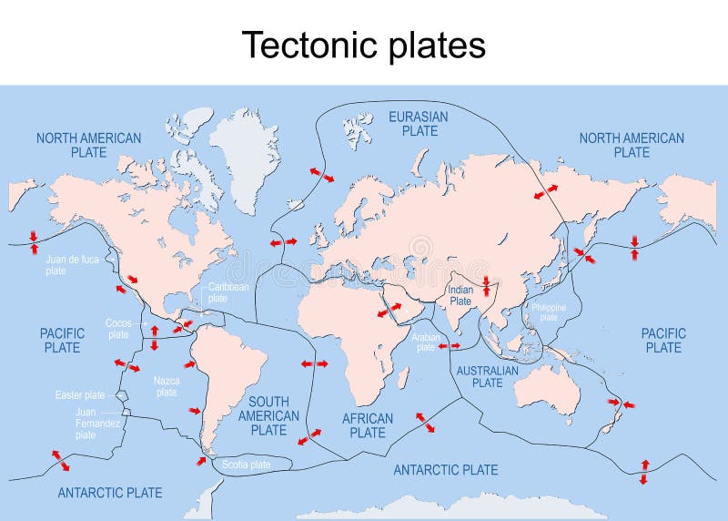
Free with trial Map of Earth`s principal tectonic plates. Earth`s lithosphere. Major and minor plates. arrows indicate direction of movement at plate boundaries. Vector illustration. Land s vectors Map of Earth`s principal tectonic plates. Earth`s lithosphere. Major and minor plates. arrows indicate direction of movement at plate boundaries. Vector
Free with trial Valentine`s Day background with a heart shaped tree and a tandem bicycle. Vector. Land s vectors Valentine`s Day background with a heart shaped tree and a tandem bicycle. Vector
Free with trial Alice and Cheshire cat. Lewis Caroll s characters in Alice in Wonderland. vector, vintage. Land s vectors Alice and Cheshire cat. Lewis Caroll s characters in Alice in Wonderland. Vector, vintage
Free with trial Vector world map for kids with cute planes and air balloons. Children's map design for wallpaper, kid's room, wall art. America, Europa, Asia, Africa, Australia, Arctica. Vector illustration. Land s vectors Vector world map for kids with cute cartoon planes and air balloons. Children's map design for wallpaper, kid's room. Vector world map for kids with. Vector world map for kids with cute planes and air balloons. Children's map design for wallpaper, kid's room, wall art. America, Europa, Asia, Africa, Australia, Arctica. Vector illustration.
Free with trial Map of the U. S. state Arizona. state of Arizona. Land s vectors Map of the U.S. state Arizona. Map of the U.S. state of Arizona
Free with trial We are proud to present some new s covering muscle classic cars and sport cars that you can use for as many purposes as you desire, especially if you are a car or motorcycle addict person. Land s vectors Vector Car. We are proud to present some new s covering muscle classic cars and sport cars that you can use for as many purposes as you desire, especially if you. We are proud to present some new s covering muscle classic cars and sport cars that you can use for as many purposes as you desire, especially if you are a car or motorcycle addict person.
Free with trial Italy Physical Map– highly detailed vector illustration. Image contains layers with shaded contours, land names, city names, water objects and it`s names, highways. Land s vectors Italy Physical Map. – highly detailed vector illustration. Image contains layers with shaded contours, land names, city names, water objects and it`s names
Free with trial Noahs Ark. Christian Bible story of Noah s Ark. With a white dove returning with olive branch from emerging land in the distance black and white coloring page. Land s vectors Noahs Ark. Christian Bible story of Noah s Ark. With a white dove returning with olive branch from emerging land in the distance black and white coloring page
Free with trial We are proud to present some new s covering muscle classic cars and sport cars that you can use for as many purposes as you desire, especially if you are a car or motorcycle addict person. Land s vectors Vector Car. We are proud to present some new s covering muscle classic cars and sport cars that you can use for as many purposes as you desire, especially if you. We are proud to present some new s covering muscle classic cars and sport cars that you can use for as many purposes as you desire, especially if you are a car or motorcycle addict person.
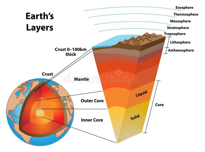
Free with trial Layers of the earth, showing the earth`s core and other structures. The core, mantle, crust, and asthenosphere, lithosphere, troposphere, stratosphere, mesosphere, thermosphere, and exosphere. Land s vectors Layers of the Earth, Detailed Slice. Layers of the earth, showing the earth`s core and other structures. The core, mantle, crust, and asthenosphere, lithosphere. Layers of the earth, showing the earth`s core and other structures. The core, mantle, crust, and asthenosphere, lithosphere, troposphere, stratosphere, mesosphere, thermosphere, and exosphere.
Free with trial Papua New Guinea Physical Map – highly detailed vector illustration. Image contains layers with shaded contours, land names, city names, water objects and it`s names, highways. Land s vectors Papua New Guinea Physical Map. – highly detailed vector illustration. Image contains layers with shaded contours, land names, city names, water objects and it
Free with trial Polar bear silhouette contour. The world`s largest land carnivore, polar bear Ursus maritimus. Land s vectors Polar bear silhouette contour. The world`s largest land carnivore, polar bear Ursus maritimus
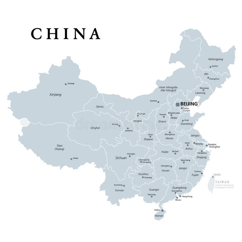
Free with trial China, gray political map, with administrative divisions. PRC, People`s Republic of China with capital Beijing, provinces with capitals and borders. English labeling. Illustration over white. Vector. Land s vectors China, gray political map, provinces, administrative divisions. China, gray political map, with administrative divisions. PRC, People`s Republic of China with. China, gray political map, with administrative divisions. PRC, People`s Republic of China with capital Beijing, provinces with capitals and borders. English labeling. Illustration over white. Vector.
Free with trial National flag of Hong Kong. Patriotic sign in official color and flower. Symbol of Special Administrative Region of the People`s Republic of China. Vector icon illustration. Land s vectors National flag of Hong Kong. Patriotic sign in official color and flower. Symbol of Special Administrative Region of the People`s Republic of China. Vector icon
Free with trial Percentage ratio of water and land on Earth`s surface. Graph shows percentage ratio of water and land on Earth`s surface. Land s vectors Percentage ratio of water and land on Earth`s surface. Graph shows percentage ratio of water and land on Earth`s surface
Free with trial Vector illustration isolated on white background. Land s vectors Terrible tornado carries Dorothy`s house in a magical land. Vector illustration isolated on white background. Vector illustration isolated on white background.
Free with trial Pond life, under the water, river`s animal, shadows, black and white,. Vector. Land s vectors Pond life, under the water, river`s animal, shadows, black and white,. Vector
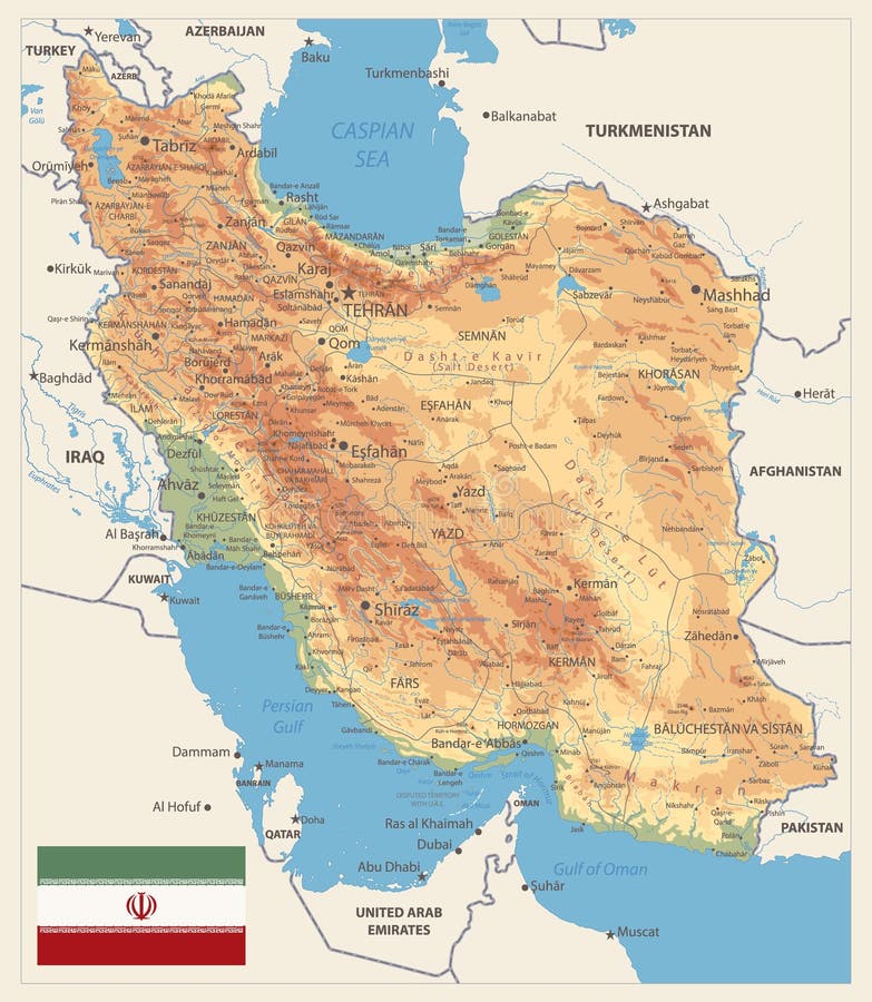
Free with trial Physical map of Iran Retro Colors. Image contains layers with shaded contours, land names, city names, water objects and it`s names. Land s vectors Physical map of Iran Retro Colors. Image contains layers with shaded contours, land names, city names, water objects and it`s names
Free with trial Map of the U. S. state Hawaii. state of Hawaii. Land s vectors Map of the U.S. state Hawaii. Map of the U.S. state of Hawaii
Free with trial Dog`s House In The Morning Garden Cartoon - Vector. Dog`s House In The Morning Garden Cartoon for decoration artwork about cartoon - Vector. Land s vectors Dog`s House In The Morning Garden Cartoon - Vector. Dog`s House In The Morning Garden Cartoon for decoration artwork about cartoon - Vector
Free with trial Vector Map of the U. S. state of Michigan. Land s vectors Vector Map of the U.S. state of Michigan.
Free with trial Agricultural landscape with farmer`s house. Green Field and cumulus clouds with the sun. Vector landscape illustration. Land s vectors Agricultural landscape with farmer`s house. Field and Cumulus clouds with the sun. Vector landscape illustration. Agricultural landscape with farmer`s house. Agricultural landscape with farmer`s house. Green Field and cumulus clouds with the sun. Vector landscape illustration.
Free with trial Agricultural landscape with farmer`s house. Green Field and cumulus clouds with the sun. Vector landscape illustration. Land s vectors Agricultural landscape with farmer`s house. Green Field and cumulus clouds with the sun. Vector landscape illustration
Free with trial Map of the U. S. state Louisiana. Land s vectors Map of the U.S. state Louisiana. Map of the U.S. state of Louisiana
Free with trial Map of the U. S. state Mississippi. Land s vectors Map of the U.S. state Mississippi. Map of the U.S. state of Mississippi
Free with trial Vector world map for kids with cute planes and air balloons. Children's map design for wallpaper, kid's room, wall art. America, Europa, Asia, Africa, Australia, Arctica. Vector illustration. Land s vectors Vector world map for kids with cute cartoon planes and air balloons. Children's map design for wallpaper, kid's room. Vector world map for kids with. Vector world map for kids with cute planes and air balloons. Children's map design for wallpaper, kid's room, wall art. America, Europa, Asia, Africa, Australia, Arctica. Vector illustration.
Free with trial Antarctica map - Earth`s southernmost continent. Vector file of Antarctica map - Earth`s southernmost continent, South Pole. Land s vectors Antarctica map - Earth`s southernmost continent. Vector file of Antarctica map - Earth`s southernmost continent, South Pole
Free with trial Vector world map for kids with cute planes and air balloons. Children's map design for wallpaper, kid's room, wall art. America, Europa, Asia, Africa, Australia, Arctica. Vector illustration. Land s vectors Vector world map for kids with cute cartoon planes and air balloons. Children's map design for wallpaper, kid's room. Vector world map for kids with. Vector world map for kids with cute planes and air balloons. Children's map design for wallpaper, kid's room, wall art. America, Europa, Asia, Africa, Australia, Arctica. Vector illustration.
Free with trial Florida - U. S. state. Contour line in black color. Vector illustration. EPS 10. Land s vectors Florida - U.S. state. Contour line in black color. Vector illustration. EPS 10.
Free with trial Poland Physical Map. Highly detailed map vector illustration. Image contains layers with shaded contours, land names, city names, water objects and it`s names, highways. Land s vectors Poland Physical Map. Highly detailed map vector illustration. Image contains layers with shaded contours, land names, city names, water objects and it`s names
Free with trial Map of the U. S. state Alaska. state of Alaska. Land s vectors Map of the U.S. state Alaska. Map of the U.S. state of Alaska
Free with trial USA / United States / U. S. outline map country shape. National borders vector illustration. Land s vectors USA / United States / U.S. outline map country shape. National borders vector illustration
Free with trial Game backgrounds You can use this background for your game application/project. It suits for game developers, or indie game developers who want to make looping GUI cartoon game for Android or iOS. The Game background is made with 100%. You can edit it with illustrator software. Best for action, shooting, adventure and other side-scrolling game platform. What will you get? Background in Adobe Illustrator CS formats (Ai). Background in Encapsulated PostScript format (EPS). Background in Transparent Portable Network Graphics (PNG). File-size: 2048×1536 – That is designed for ipad. More over you can edit it since it is and layered. Compatible with Adobe Illustrator CS and above. The background’s is 100%. Tileable horizontally. Easy to change color. Land s vectors Game backgrounds. You can use this background for your game application/project. It suits for game developers, or indie game developers who want to make looping. Game backgrounds You can use this background for your game application/project. It suits for game developers, or indie game developers who want to make looping GUI cartoon game for Android or iOS. The Game background is made with 100% . You can edit it with illustrator software. Best for action, shooting, adventure and other side-scrolling game platform. What will you get? Background in Adobe Illustrator CS formats (Ai). Background in Encapsulated PostScript format (EPS). Background in Transparent Portable Network Graphics (PNG). File-size: 2048×1536 – That is designed for ipad. More over you can edit it since it is and layered. Compatible with Adobe Illustrator CS and above. The background’s is 100% . Tileable horizontally. Easy to change color.
Free with trial An image of a small cruise ship anchored just off shore. E. P. S. 10 vector file included with image, on white. Land s vectors Cruise ship near beach. An image of a small cruise ship anchored just off shore. E.P.S. 10 vector file included with image, on white. An image of a small cruise ship anchored just off shore. E.P.S. 10 vector file included with image, on white.
Free with trial Christmas card, Santa`s arrival. Christmas card. Winter landscape, snow, house and pine trees. Land s vectors Christmas card, Santa`s arrival. Christmas card. Winter landscape, snow, house and pine trees
Free with trial Desert islands. Two images of small desert islands, in the daytime and at sunset. E. P. S. 10 vector file included with image, isolated on white. Land s vectors Desert islands. Two images of small desert islands, in the daytime and at sunset. E.P.S. 10 vector file included with image, isolated on white
Free with trial Indian Ocean political map. Countries and borders. World`s third largest ocean division, bounded by Africa, Asia, Antarctica and Australia. Named after India. Illustration. English labeling. Vector. Land s vectors Indian Ocean political map. Countries and borders. World`s third largest ocean division, bounded by Africa, Asia, Antarctica and Australia. Named after India
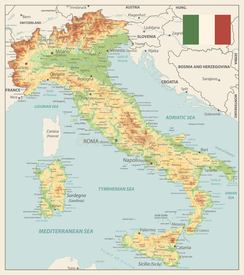
Free with trial Italy Physical Map Vinatge Colors - Image contains layers with shaded contours, land names, city names, water objects and it`s names - Highly detailed vector illustration. Land s vectors Italy Physical Map Vinatge Colors. Image contains layers with shaded contours, land names, city names, water objects and it`s names - Highly detailed vector
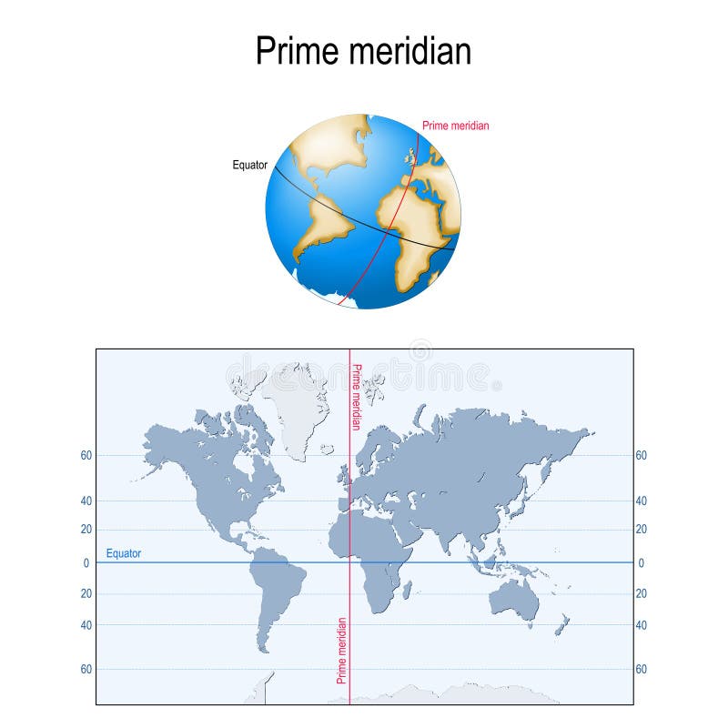
Free with trial Earth`s Equator, and Prime meridian on a globe. map with parallels, longitude and latitude. Geographic coordinate system. Land s vectors Equator, and Prime meridian. globe, and map. Earth`s Equator, and Prime meridian on a globe. map with parallels, longitude and latitude. Geographic coordinate. Earth`s Equator, and Prime meridian on a globe. map with parallels, longitude and latitude. Geographic coordinate system
Free with trial Italy Detailed Physical Map - Image contains layers with shaded contours, land names, city names, water objects and it`s names - Highly detailed vector illustration. Land s vectors Italy Detailed Physical Map. Image contains layers with shaded contours, land names, city names, water objects and it`s names - Highly detailed vector
Free with trial Illustration of summer fields with a mill and a balloon in the s. Ky. Land s vectors Illustration of summer fields with a mill and a balloon in the s. Ky
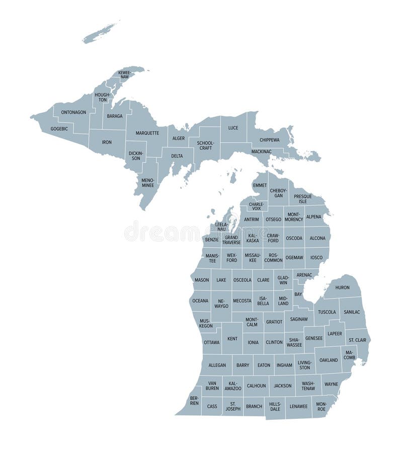
Free with trial Michigan counties, gray political map. A state in the Great Lakes region of the Upper Midwest of the United States, subdivided into 83 counties. Map with county boundaries and names. Illustration. Land s vectors U.S. state of Michigan, subdivided into 83 counties, gray political map. Michigan counties, gray political map. A state in the Great Lakes region of the Upper. Michigan counties, gray political map. A state in the Great Lakes region of the Upper Midwest of the United States, subdivided into 83 counties. Map with county boundaries and names. Illustration
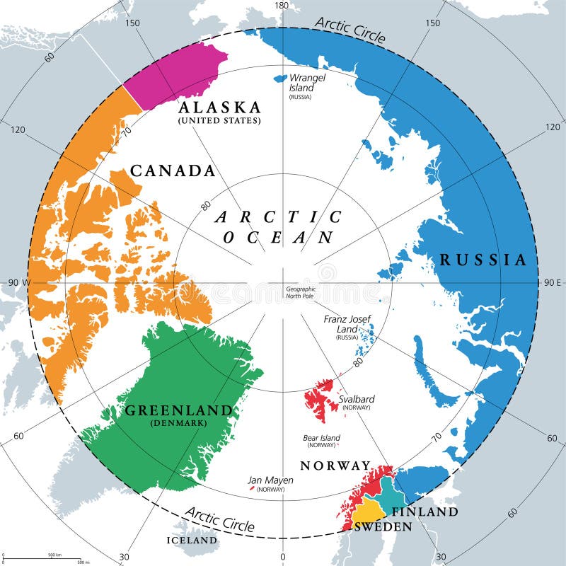
Free with trial Countries within the Arctic Circle, political map. Countries within about 66 degrees north the Equator and North Pole. Alaska (U. S. ), Canada, Finland, Greenland (Denmark), Norway, Sweden and Russia. Land s vectors Countries within the Arctic Circle, Arctic Region countries, political map. Countries within the Arctic Circle, political map. Countries within about 66 degrees. Countries within the Arctic Circle, political map. Countries within about 66 degrees north the Equator and North Pole. Alaska (U.S.), Canada, Finland, Greenland (Denmark), Norway, Sweden and Russia.
Free with trial U. S. state Kansas black map on white background. Land s vectors Kansas black map on white background. U.S. state Kansas black map on white background. U.S. state Kansas black map on white background.
Free with trial U. S. states - map of Minnesota. Hand made. Rivers and lakes are shown. Please look at my other images of cartographic series - they are all very detailed and carefully drawn by hand WITH RIVERS AND LAKES. Land s vectors Map of Minnesota with lakes and rivers. U.S. states - map of Minnesota. Hand made. Rivers and lakes are shown. Please look at my other images of cartographic. U.S. states - map of Minnesota. Hand made. Rivers and lakes are shown. Please look at my other images of cartographic series - they are all very detailed and carefully drawn by hand WITH RIVERS AND LAKES.
Free with trial U. S. states - map of Texas. Hand made. Rivers and lakes are shown. Please look at my other images of cartographic series - they are all very detailed and carefully drawn by hand WITH RIVERS AND LAKES. Land s vectors Map of Texas with lakes and rivers. U.S. states - map of Texas. Hand made. Rivers and lakes are shown. Please look at my other images of cartographic series. U.S. states - map of Texas. Hand made. Rivers and lakes are shown. Please look at my other images of cartographic series - they are all very detailed and carefully drawn by hand WITH RIVERS AND LAKES.
Free with trial Parable of Jesus Christ about the talent buried in the ground. An illustration of Jesus Christ`s parable of the talent hidden in the earth. Land s vectors Parable of Jesus Christ about the talent buried in the ground. An illustration of Jesus Christ`s parable of the talent hidden in the earth
Free with trial Eco Friendly, green energy concept, save the world vector illustration, flat design Brochure Template. Land s vectors Brochure Template Environment concept. Let`s Save the World Together. Eco Friendly, green energy concept, save the world vector illustration, flat design. Eco Friendly, green energy concept, save the world vector illustration, flat design Brochure Template
Free with trial Inside Out background movie inspired emotions. Inside out movie emotions concept abstract background with circles five colors. Land s vectors Inside Out background movie inspired emotions. Inside out movie emotions concept abstract background with circles five colors
Free with trial Italy Physical Map White and Grey - Image contains layers with shaded contours, land names, city names, water objects and it`s names - Highly detailed vector illustration. Land s vectors Italy Physical Map White and Grey. Image contains layers with shaded contours, land names, city names, water objects and it`s names - Highly detailed vector
Free with trial European flags. A collection of vector illustration European flags. E. P. S. 10 vector file included with image, on white. Land s vectors European flags. A collection of vector illustration European flags. E.P.S. 10 vector file included with image, on white
Free with trial Vector Illustration of Kentucky state flag. Vector Illustration of Kentucky U. S. state flag. Land s vectors Vector Illustration of Kentucky state flag. Vector Illustration of Kentucky U.S. state flag
Free with trial Vector Illustration of Washington state flag. Vector Illustration of Washington U. S. state flag. Land s vectors Vector Illustration of Washington state flag. Vector Illustration of Washington U.S. state flag
Free with trial Cars Land. One of the star attractions in Disney California Adventure Park. It is cozy place and comfort foods at Flo’s V8 Café. Great place to have fun. Cartoon flat vector illustration. Land s vectors Cars Land. One of the star attractions in Disney California Adventure Park. It is cozy place and comfort foods at Flo’s V8 Caf. é. Great place to have fun. Cars Land. One of the star attractions in Disney California Adventure Park. It is cozy place and comfort foods at Flo’s V8 Café. Great place to have fun. Cartoon flat vector illustration
Free with trial Vegetable Salad, Illustration of Hand Drawn Sketch Delicious Fresh Green Land Cress, Lettuce and Lamb`s Quarters Plants Isolated on White Background. Land s vectors Hand Drawn of Land Cress, Lettuce and Lamb`s Quarters. Vegetable Salad, Illustration of Hand Drawn Sketch Delicious Fresh Green Land Cress, Lettuce and Lamb`s. Vegetable Salad, Illustration of Hand Drawn Sketch Delicious Fresh Green Land Cress, Lettuce and Lamb`s Quarters Plants Isolated on White Background.
Free with trial Oregon Coast, political map. Coastal region of U. S. state of Oregon, bordered by Pacific Ocean to the west and Oregon Coast Range to the east, stretching from Columbia River to the California border. Land s vectors Oregon Coast, coastal region of U.S. state of Oregon, political map. Oregon Coast, political map. Coastal region of U.S. state of Oregon, bordered by Pacific. Oregon Coast, political map. Coastal region of U.S. state of Oregon, bordered by Pacific Ocean to the west and Oregon Coast Range to the east, stretching from Columbia River to the California border.
Free with trial New Jersey, U. S. state, subdivided into 21 counties, multi colored political map with capital Trenton, borders and county names. State in the Mid-Atlantic and Northeastern region of the United States. Land s vectors New Jersey, U.S. state, subdivided into 21 counties, multi colored map. New Jersey, U.S. state, subdivided into 21 counties, multi colored political map with. New Jersey, U.S. state, subdivided into 21 counties, multi colored political map with capital Trenton, borders and county names. State in the Mid-Atlantic and Northeastern region of the United States.
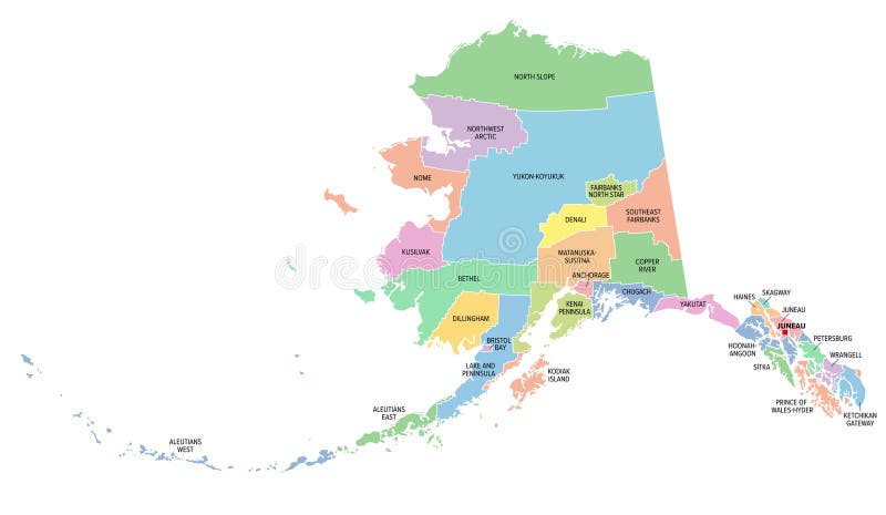
Free with trial Alaska, U. S. state, subdivided into 19 organized boroughs and 11 census areas, multi colored political map. State on the northwest extremity of North America in the Western USA region. Last Frontier. Land s vectors Alaska, U.S. state, boroughs and census areas, multi colored political map. Alaska, U.S. state, subdivided into 19 organized boroughs and 11 census areas, multi. Alaska, U.S. state, subdivided into 19 organized boroughs and 11 census areas, multi colored political map. State on the northwest extremity of North America in the Western USA region. Last Frontier.
Free with trial Oregon Coast, gray political map. Coastal region of U. S. state of Oregon, bordered by Pacific Ocean to the west and Oregon Coast Range to the east, stretching from Columbia River to California border. Land s vectors Oregon Coast, coastal region of U.S. state of Oregon, gray political map. Oregon Coast, gray political map. Coastal region of U.S. state of Oregon, bordered by. Oregon Coast, gray political map. Coastal region of U.S. state of Oregon, bordered by Pacific Ocean to the west and Oregon Coast Range to the east, stretching from Columbia River to California border.
Free with trial Idaho, U. S. state, subdivided into 44 counties, multi colored political map with capital Boise, borders and county names. State in the Mountain West region of the USA. Gem State, or also Potato State. Land s vectors Idaho, U.S. state, subdivided into 44 counties, multi colored map. Idaho, U.S. state, subdivided into 44 counties, multi colored political map with capital Boise. Idaho, U.S. state, subdivided into 44 counties, multi colored political map with capital Boise, borders and county names. State in the Mountain West region of the USA. Gem State, or also Potato State.
Free with trial Virginia, U. S. state, subdivided into 95 counties and 38 independent cities, colored political map with capital Richmond, and county names. State in the Southeastern and Mid-Atlantic regions of USA. Land s vectors Virginia, U.S. state, counties and independent cities, colored map. Virginia, U.S. state, subdivided into 95 counties and 38 independent cities, colored. Virginia, U.S. state, subdivided into 95 counties and 38 independent cities, colored political map with capital Richmond, and county names. State in the Southeastern and Mid-Atlantic regions of USA.
Free with trial Oklahoma, U. S. state, political map with borders and county names. State in the South Central region of the USA, subdivided into 77 counties. Native America, Land of the Red Man, and Sooner State. Land s vectors Oklahoma, U.S. state, subdivided into 77 counties, political map. Oklahoma, U.S. state, political map with borders and county names. State in the South Central. Oklahoma, U.S. state, political map with borders and county names. State in the South Central region of the USA, subdivided into 77 counties. Native America, Land of the Red Man, and Sooner State.
Free with trial Dream land of spring and summer. Nature`s dream land with meadows, trees, a road long a river and moutains. Land s vectors Dream land of spring and summer. Nature`s dream land with meadows, trees, a road long a river and moutains
Free with trial Utah, U. S. state, subdivided into 29 counties, multi colored political map with capital Salt Lake City, borders and county names. State in the Mountain West region of Western USA. The Beehive State. Land s vectors Utah, U.S. state, subdivided into 29 counties, multi colored map. Utah, U.S. state, subdivided into 29 counties, multi colored political map with capital Salt. Utah, U.S. state, subdivided into 29 counties, multi colored political map with capital Salt Lake City, borders and county names. State in the Mountain West region of Western USA. The Beehive State.
Free with trial West Virginia, U. S. state, subdivided into 55 counties, multi colored political map with capital Charleston, borders and county names. State in the Southeastern and Mid-Atlantic regions of the USA. Land s vectors West Virginia, U.S. state, subdivided into 55 counties, colored map. West Virginia, U.S. state, subdivided into 55 counties, multi colored political map with. West Virginia, U.S. state, subdivided into 55 counties, multi colored political map with capital Charleston, borders and county names. State in the Southeastern and Mid-Atlantic regions of the USA.
Free with trial Candy land chocolate biscuit houses. Magic fantastic cake castles with cream and glaze on top decorated with lollipops. Ice cream fairy tale tasty building desserts isolated vector set. Land s vectors 2206 S ST Candy land chocolate biscuit houses. Candy land chocolate biscuit houses. Magic fantastic cake castles with cream and glaze on top decorated with. Candy land chocolate biscuit houses. Magic fantastic cake castles with cream and glaze on top decorated with lollipops. Ice cream fairy tale tasty building desserts isolated vector set
Free with trial Oregon, U. S. state, subdivided into 36 counties, multi colored political map with capital Salem, borders and county names. State in the Pacific Northwest region of the United States. The Beaver State. Land s vectors Oregon, U.S. state, subdivided into 36 counties, multi colored map. Oregon, U.S. state, subdivided into 36 counties, multi colored political map with capital. Oregon, U.S. state, subdivided into 36 counties, multi colored political map with capital Salem, borders and county names. State in the Pacific Northwest region of the United States. The Beaver State.
Free with trial Kids logo vector set. Logo collection of kids club, land, playground, zone, hobby, arts. Colorful promo signs and creative idea for children`s playing space. Vector icons and symbols set of child logo. Land s vectors Kids logo vector set. Logo collection of kids club, land, playground, zone, hobby, arts. Vector icons and symbols set of child. Kids logo vector set. Logo. Kids logo vector set. Logo collection of kids club, land, playground, zone, hobby, arts. Colorful promo signs and creative idea for children`s playing space. Vector icons and symbols set of child logo
Free with trial River in rock canyon desert cartoon landscape background. Dry sand land and hot mountain in national utah park with boulder stone. Ancient cliff formation near water panoramic summer illustration. Land s vectors River in rock canyon desert cartoon landscape background. Dry sand land and hot mountain in national utah park with boulder s... River in rock canyon desert. River in rock canyon desert cartoon landscape background. Dry sand land and hot mountain in national utah park with boulder stone. Ancient cliff formation near water panoramic summer illustration..
Free with trial Dukes County, Commonwealth of Massachusetts U. S. county, United States of America, US map vector illustration, scribble sketch Martha`s Vineyard, Chappaquiddick, Elizabeth and Nomans Land island map,. Land s vectors Dukes County, Commonwealth of Massachusetts U.S. county, United States of America, US map vector illustration, scribble sketch. Martha`s Vineyard. Dukes County, Commonwealth of Massachusetts U.S. county, United States of America, US map vector illustration, scribble sketch Martha`s Vineyard, Chappaquiddick, Elizabeth and Nomans Land island map,
Free with trial Dukes County, Commonwealth of Massachusetts U. S. county, United States of America, US map vector illustration, scribble sketch Martha`s Vineyard, Chappaquiddick, Elizabeth and Nomans Land island map,. Land s vectors Dukes County, Commonwealth of Massachusetts U.S. county, United States of America, US map vector illustration, scribble sketch. Martha`s Vineyard. Dukes County, Commonwealth of Massachusetts U.S. county, United States of America, US map vector illustration, scribble sketch Martha`s Vineyard, Chappaquiddick, Elizabeth and Nomans Land island map,
Free with trial Great Lakes Region of North America, political map. Highlighted in blue, a region, centered on the Great Lakes, including 8 U. S. states and Canadian province of Ontario. Isolated illustration. Vector. Land s vectors Great Lakes Region of North America, political map. Highlighted in blue, a region, centered on the Great Lakes, including 8 U.S. states and Canadian province
Free with trial Girl`s silhouette on beach. Girl`s silhouette on sunset tropic beach. Land s vectors Girl`s silhouette on beach. Girl`s silhouette on sunset tropic beach
 Sign in