Free with trial City skyline North America. Large set of silhouettes of American cities. Large cities vectors City skyline North America. Large set of silhouettes of American cities
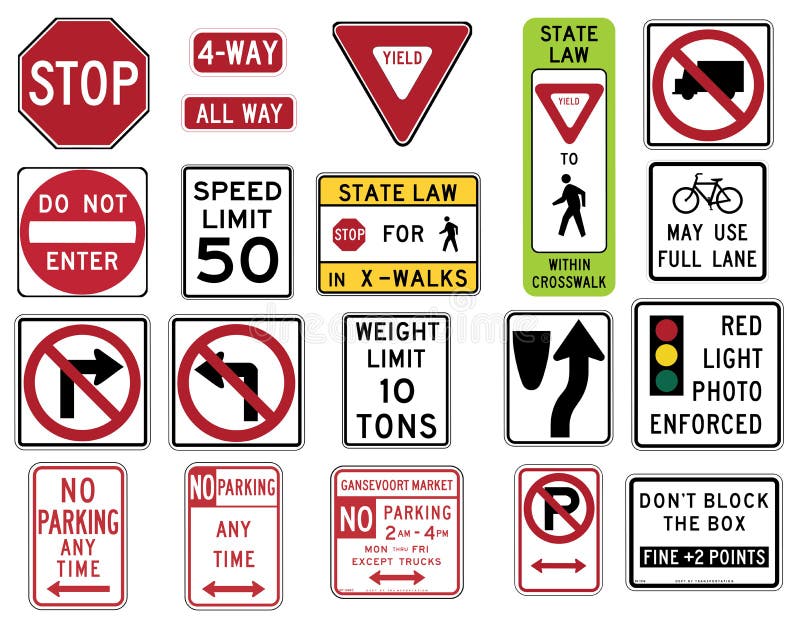
Free with trial Vector Illustration collection of the select Traffic Signs in the United States, isolated on white background. You can find other road signs in my portfolio. EPS file available. In the United States, road signs are, for the most part, standardized by federal regulations, most notably in the Manual on Uniform Traffic Control Devices (MUTCD) and its companion volume the Standard Highway Signs (SHS). There currently are no plans for adopting the Vienna Convention on Road Signs and Signals standards. Twenty-three states along with the District of Columbia and Puerto Rico use the manual without any alterations, 20 states have adopted it in conjunction with a supplemental volume, and seven states have a state version in substantial conformance to the MUTCD. There are also localized versions that are used in large cities such as New York City which use a naming system compatible with the MUTCD and/or state supplement. The MUTCD and SHS establish seven general categories of signs for road and highway use. Included illustrations are select examples of the following MUTCD categories: -- R1 Series STOP and YIELD -- R2 Series Speed Limit -- R3 Series Lane Usage and Turns (Left and Right Turn) -- R4 Regulation of Movement -- R5 Series: Exclusionary -- R7 Series: Parking. Large cities vectors Traffic Signs in the United States - Regulatory Series. Vector Illustration collection of the select Traffic Signs in the United States, isolated on white. Vector Illustration collection of the select Traffic Signs in the United States, isolated on white background. You can find other road signs in my portfolio. EPS file available. In the United States, road signs are, for the most part, standardized by federal regulations, most notably in the Manual on Uniform Traffic Control Devices (MUTCD) and its companion volume the Standard Highway Signs (SHS). There currently are no plans for adopting the Vienna Convention on Road Signs and Signals standards. Twenty-three states along with the District of Columbia and Puerto Rico use the manual without any alterations, 20 states have adopted it in conjunction with a supplemental volume, and seven states have a state version in substantial conformance to the MUTCD. There are also localized versions that are used in large cities such as New York City which use a naming system compatible with the MUTCD and/or state supplement. The MUTCD and SHS establish seven general categories of signs for road and highway use. Included illustrations are select examples of the following MUTCD categories: -- R1 Series STOP and YIELD -- R2 Series Speed Limit -- R3 Series Lane Usage and Turns (Left and Right Turn) -- R4 Regulation of Movement -- R5 Series: Exclusionary -- R7 Series: Parking
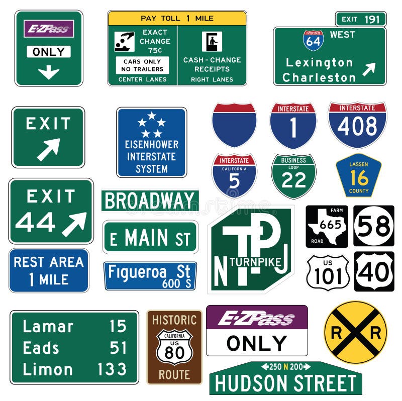
Free with trial Vector Illustration collection of the select Traffic Signs in the United States, isolated on white background. You can find other road signs in my portfolio. EPS file available. Guide signs are essential to direct road users along streets and highways, to inform them of intersecting routes, rnto direct them to cities, towns, villages, or other important destinations, to identify nearby rivers and streams, parks, forests, and historical sites, and generally to give such information as will help them along their way in the most simple, direct manner possible. rnrnIn the United States, road signs are, for the most part, standardized by federal regulations, most notably in the Manual on Uniform Traffic Control Devices (MUTCD) and its companion volume the Standard Highway Signs (SHS). There currently are no plans for adopting the Vienna Convention on Road Signs and Signals standards. Twenty-three states along with the District of Columbia and Puerto Rico use the manual without any alterations, 20 states have adopted it in conjunction with a supplemental volume, and seven states have a state version in substantial conformance to the MUTCD. There are also localized versions that are used in large cities such as New York City which use a naming system compatible with the MUTCD and/or state supplement. The MUTCD and SHS establish seven general categories of signs for road and highway use. rnrnIncluded illustrations are select examples of the MUTCD Guide Signs categories. rn. Large cities vectors Traffic Guide Signs in the United States. Vector Illustration collection of the select Traffic Signs in the United States, isolated on white background. You can. Vector Illustration collection of the select Traffic Signs in the United States, isolated on white background. You can find other road signs in my portfolio. EPS file available. Guide signs are essential to direct road users along streets and highways, to inform them of intersecting routes, rnto direct them to cities, towns, villages, or other important destinations, to identify nearby rivers and streams, parks, forests, and historical sites, and generally to give such information as will help them along their way in the most simple, direct manner possible.rnrnIn the United States, road signs are, for the most part, standardized by federal regulations, most notably in the Manual on Uniform Traffic Control Devices (MUTCD) and its companion volume the Standard Highway Signs (SHS). There currently are no plans for adopting the Vienna Convention on Road Signs and Signals standards. Twenty-three states along with the District of Columbia and Puerto Rico use the manual without any alterations, 20 states have adopted it in conjunction with a supplemental volume, and seven states have a state version in substantial conformance to the MUTCD. There are also localized versions that are used in large cities such as New York City which use a naming system compatible with the MUTCD and/or state supplement. The MUTCD and SHS establish seven general categories of signs for road and highway use.rnrnIncluded illustrations are select examples of the MUTCD Guide Signs categories.rn
Free with trial Cities in Mexico. Vector set for you design. Large cities vectors Cities in Mexico. Vector set for you design
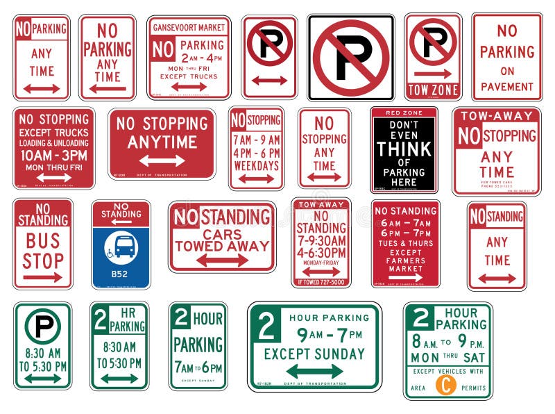
Free with trial Vector Illustration collection of the select Traffic Signs in the United States, isolated on white background. You can find other road signs in my portfolio. EPS file available. rnrnIn the United States, road signs are, for the most part, standardized by federal regulations, most notably in the Manual on Uniform Traffic Control Devices (MUTCD) and its companion volume the Standard Highway Signs (SHS). There currently are no plans for adopting the Vienna Convention on Road Signs and Signals standards. rnTwenty-three states along with the District of Columbia and Puerto Rico use the manual without any alterations, 20 states have adopted it in conjunction with a supplemental volume, and seven states have a state version in substantial conformance to the MUTCD. There are also localized versions that are used in large cities such as New York City which use a naming system compatible with the MUTCD and/or state supplement. The MUTCD and SHS establish seven general categories of signs for road and highway use. rnrnIncluded illustrations are select examples of the following MUTCD categories:rn-- R7 Series: Parkingrnrn. Large cities vectors Traffic Signs in the United States - No Parking. Vector Illustration collection of the select Traffic Signs in the United States, isolated on white background. Vector Illustration collection of the select Traffic Signs in the United States, isolated on white background. You can find other road signs in my portfolio. EPS file available.rnrnIn the United States, road signs are, for the most part, standardized by federal regulations, most notably in the Manual on Uniform Traffic Control Devices (MUTCD) and its companion volume the Standard Highway Signs (SHS). There currently are no plans for adopting the Vienna Convention on Road Signs and Signals standards.rnTwenty-three states along with the District of Columbia and Puerto Rico use the manual without any alterations, 20 states have adopted it in conjunction with a supplemental volume, and seven states have a state version in substantial conformance to the MUTCD. There are also localized versions that are used in large cities such as New York City which use a naming system compatible with the MUTCD and/or state supplement. The MUTCD and SHS establish seven general categories of signs for road and highway use.rnrnIncluded illustrations are select examples of the following MUTCD categories:rn-- R7 Series: Parkingrnrn
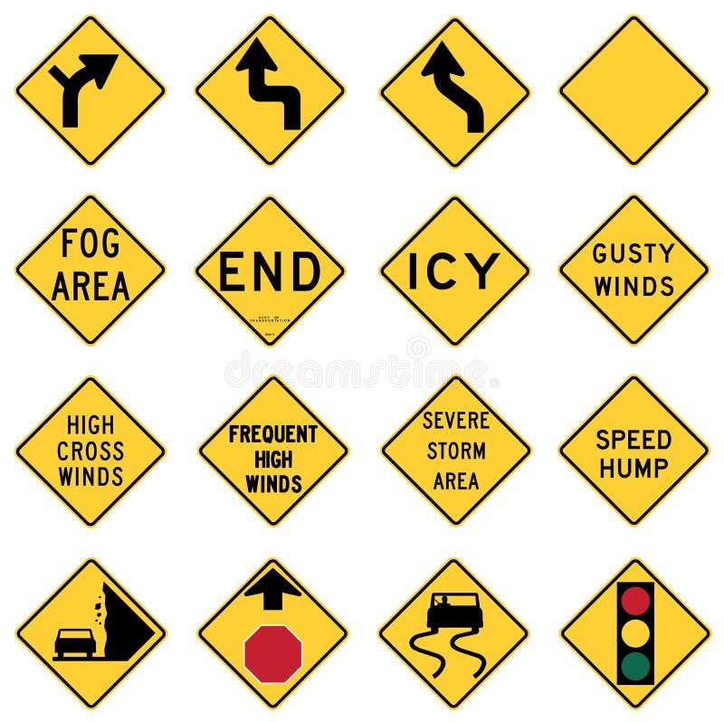
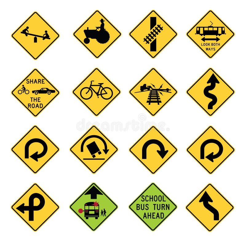
Free with trial Vector Illustration collection of the select Traffic Signs in the United States, isolated on white background. You can find other road signs in my portfolio. EPS file available. Warning signs are found in the W series of the national MUTCD. They highlight existing conditions, such as a curve, school, dead end street, or traffic signal. They can also warn possible danger such as bumps, bicycles, low flying aircraft or emergency vehicles. These signs are either yellow or fluorescent yellow in color and with the exception of a few signs are usually diamond shaped and sometimes have square or rectangular smaller signs or plaques associated with them. Most W series signs can also be found in with orange backgrounds, for temporary use in situations such as construction zones. Some of the temporary use signs are only for use in temporary situations. In the United States, road signs are, for the most part, standardized by federal regulations, most notably in the Manual on Uniform Traffic Control Devices (MUTCD) and its companion volume the Standard Highway Signs (SHS). There currently are no plans for adopting the Vienna Convention on Road Signs and Signals standards. Twenty-three states along with the District of Columbia and Puerto Rico use the manual without any alterations, 20 states have adopted it in conjunction with a supplemental volume, and seven states have a state version in substantial conformance to the MUTCD. There are also localized versions that are used in large cities such as New York City which use a naming system compatible with the MUTCD and/or state supplement. The MUTCD and SHS establish seven general categories of signs for road and highway use. Included illustrations are select examples of the MUTCD Warning Signs categories. Large cities vectors Traffic Warning Signs in the United States. Vector Illustration collection of the select Traffic Signs in the United States, isolated on white background. You. Vector Illustration collection of the select Traffic Signs in the United States, isolated on white background. You can find other road signs in my portfolio. EPS file available. Warning signs are found in the W series of the national MUTCD. They highlight existing conditions, such as a curve, school, dead end street, or traffic signal. They can also warn possible danger such as bumps, bicycles, low flying aircraft or emergency vehicles. These signs are either yellow or fluorescent yellow in color and with the exception of a few signs are usually diamond shaped and sometimes have square or rectangular smaller signs or plaques associated with them. Most W series signs can also be found in with orange backgrounds, for temporary use in situations such as construction zones. Some of the temporary use signs are only for use in temporary situations. In the United States, road signs are, for the most part, standardized by federal regulations, most notably in the Manual on Uniform Traffic Control Devices (MUTCD) and its companion volume the Standard Highway Signs (SHS). There currently are no plans for adopting the Vienna Convention on Road Signs and Signals standards. Twenty-three states along with the District of Columbia and Puerto Rico use the manual without any alterations, 20 states have adopted it in conjunction with a supplemental volume, and seven states have a state version in substantial conformance to the MUTCD. There are also localized versions that are used in large cities such as New York City which use a naming system compatible with the MUTCD and/or state supplement. The MUTCD and SHS establish seven general categories of signs for road and highway use. Included illustrations are select examples of the MUTCD Warning Signs categories.
Free with trial Vector Illustration collection of the select Traffic Signs in the United States, isolated on white background. You can find other road signs in my portfolio. EPS file available. Warning signs are found in the W series of the national MUTCD. They highlight existing conditions, such as a curve, school, dead end street, or traffic signal. They can also warn possible danger such as bumps, bicycles, low flying aircraft or emergency vehicles. These signs are either yellow or fluorescent yellow in color and with the exception of a few signs are usually diamond shaped and sometimes have square or rectangular smaller signs or plaques associated with them. Most W series signs can also be found in with orange backgrounds, for temporary use in situations such as construction zones. Some of the temporary use signs are only for use in temporary situations. In the United States, road signs are, for the most part, standardized by federal regulations, most notably in the Manual on Uniform Traffic Control Devices (MUTCD) and its companion volume the Standard Highway Signs (SHS). There currently are no plans for adopting the Vienna Convention on Road Signs and Signals standards. Twenty-three states along with the District of Columbia and Puerto Rico use the manual without any alterations, 20 states have adopted it in conjunction with a supplemental volume, and seven states have a state version in substantial conformance to the MUTCD. There are also localized versions that are used in large cities such as New York City which use a naming system compatible with the MUTCD and/or state supplement. The MUTCD and SHS establish seven general categories of signs for road and highway use. Included illustrations are select examples of the MUTCD Warning Signs categories. Large cities vectors Traffic Warning Signs in the United States. Vector Illustration collection of the select Traffic Signs in the United States, isolated on white background. You. Vector Illustration collection of the select Traffic Signs in the United States, isolated on white background. You can find other road signs in my portfolio. EPS file available. Warning signs are found in the W series of the national MUTCD. They highlight existing conditions, such as a curve, school, dead end street, or traffic signal. They can also warn possible danger such as bumps, bicycles, low flying aircraft or emergency vehicles. These signs are either yellow or fluorescent yellow in color and with the exception of a few signs are usually diamond shaped and sometimes have square or rectangular smaller signs or plaques associated with them. Most W series signs can also be found in with orange backgrounds, for temporary use in situations such as construction zones. Some of the temporary use signs are only for use in temporary situations. In the United States, road signs are, for the most part, standardized by federal regulations, most notably in the Manual on Uniform Traffic Control Devices (MUTCD) and its companion volume the Standard Highway Signs (SHS). There currently are no plans for adopting the Vienna Convention on Road Signs and Signals standards. Twenty-three states along with the District of Columbia and Puerto Rico use the manual without any alterations, 20 states have adopted it in conjunction with a supplemental volume, and seven states have a state version in substantial conformance to the MUTCD. There are also localized versions that are used in large cities such as New York City which use a naming system compatible with the MUTCD and/or state supplement. The MUTCD and SHS establish seven general categories of signs for road and highway use. Included illustrations are select examples of the MUTCD Warning Signs categories.
Free with trial Vector illustration of three city skylines on white background. Large cities vectors City skyline choice. Vector illustration of three city skylines on white background. Vector illustration of three city skylines on white background.
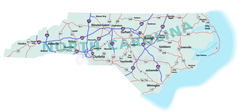
Free with trial North Carolina state road map with Interstates, U. S. Highways and state roads. All elements on separate layers (Fill, Roads, Cities, Outline) for easy editing. Map created December 3, 2009. ZIP File contains EPS-8 Adobe Illustrator file, Illustrator CS3 file, and large JPG file, 6806x3120. Source: Public domain National Planning Network ( and United States. Large cities vectors North Carolina State Interstate Map. North Carolina state road map with Interstates, U.S. Highways and state roads. All elements on separate layers (Fill. North Carolina state road map with Interstates, U.S. Highways and state roads. All elements on separate layers (Fill, Roads, Cities, Outline) for easy editing. Map created December 3, 2009. ZIP File contains EPS-8 Adobe Illustrator file, Illustrator CS3 file, and large JPG file, 6806x3120. Source: Public domain National Planning Network ( and United States
Free with trial Florida state road map with Interstates, U. S. Highways and state roads. All elements on 5 separate layers (State Fill, State Outline, Water, Roads, Cities) for easy editing. Map created January 15, 2009. ZIP File contains EPS-8 Adobe Illustrator file, Illustrator CS3 file, and large JPG file, 4350x4162. Source: Public domain National Planning Network ( and. Large cities vectors Florida State Interstate Map. Florida state road map with Interstates, U.S. Highways and state roads. All elements on 5 separate layers (State Fill, State. Florida state road map with Interstates, U.S. Highways and state roads. All elements on 5 separate layers (State Fill, State Outline, Water, Roads, Cities) for easy editing. Map created January 15, 2009. ZIP File contains EPS-8 Adobe Illustrator file, Illustrator CS3 file, and large JPG file, 4350x4162. Source: Public domain National Planning Network ( and
Free with trial USA and Canada large detailed political map with states, provinces and capital cities in USA and Canada. Large cities vectors USA and Canada large detailed political map with states, provinces and capital cities. In USA and Canada
Free with trial Cities of India. For you design. Large cities vectors Cities of India. For you design
Free with trial United States of America Map. Icons, location indicators, states, large cities. Large cities vectors Detailed map of the United States of America. Big sities. Icons, location indicators. United States of America Map. Icons, location indicators, states, large. United States of America Map. Icons, location indicators, states, large cities
Free with trial Cities in Canada. Famous places of major cities in Canada. Large cities vectors Cities in Canada. Famous places of major cities in Canada
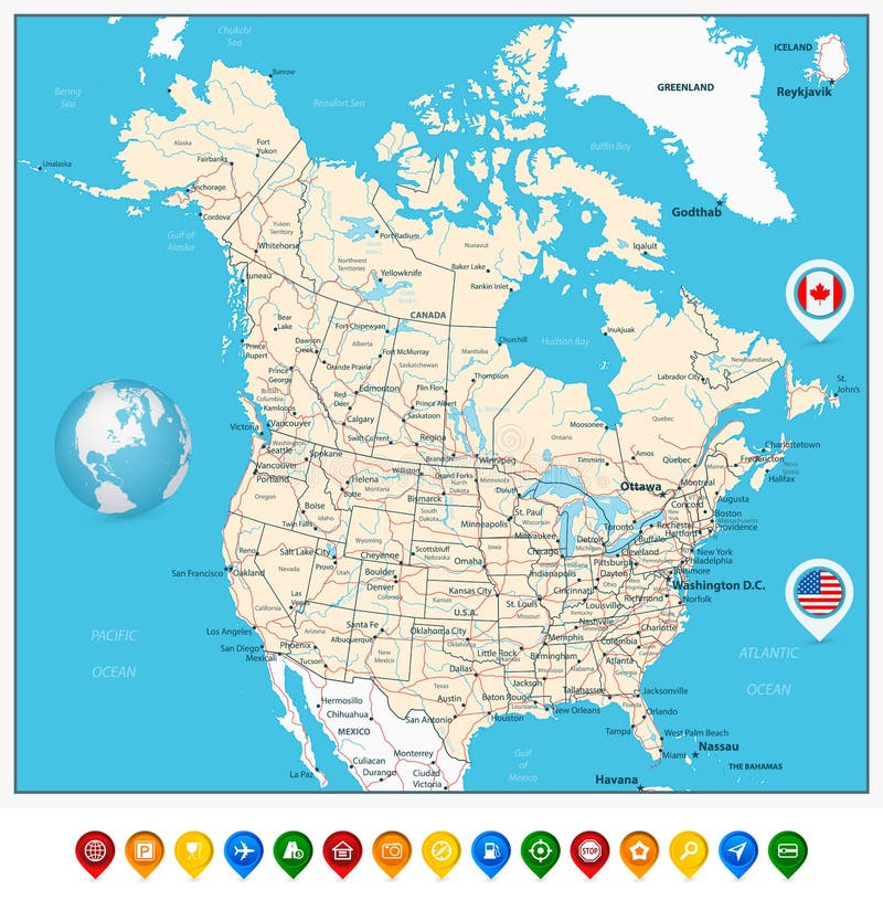
Free with trial USA and Canada large detailed political map with map pointers, states, provinces and capital cities in USA and Canada. Large cities vectors USA and Canada large detailed political map with map pointers. States, provinces and capital cities in USA and Canada
Free with trial Cities in Saudi Arabia. Famous Places cities. Large cities vectors Cities in Saudi Arabia. Famous Places cities
Free with trial Cities of Ireland. Famous Places Ireland cities. Large cities vectors Cities of Ireland. Famous Places Ireland cities
Free with trial Cities in Slovakia. Famous Places Slovakia cities. Large cities vectors Cities in Slovakia. Famous Places Slovakia cities
Free with trial Cities in Pakistan. Famous Places Pakistan cities. Large cities vectors Cities in Pakistan. Famous Places Pakistan cities
Free with trial Political World Map Retro Colors - borders, countries and cities - Detailed World Map vector illustration - All elements are separated in editable layers clearly labeled - Vector. Large cities vectors Political World Map Retro Colors. Borders, countries and cities - Detailed World Map vector illustration - All elements are separated in editable layers. Political World Map Retro Colors - borders, countries and cities - Detailed World Map vector illustration - All elements are separated in editable layers clearly labeled - Vector
Free with trial Political World Map Vintage Colors and Bathymetry - borders, countries, roads and cities - Detailed World Map vector illustration - All elements are separated in editable layers clearly labeled - Vector. Large cities vectors Political World Map Vintage Colors and Bathymetry. Borders, countries, roads and cities - Detailed World Map vector illustration - All elements are separated. Political World Map Vintage Colors and Bathymetry - borders, countries, roads and cities - Detailed World Map vector illustration - All elements are separated in editable layers clearly labeled - Vector
Free with trial Monochrome Scandinavia map. Vector Scandinavia countries black map. Large cities vectors Monochrome Scandinavia map. Vector Scandinavia countries black map
Free with trial Large and detailed map of Romania with all rivers and lakes. Large cities vectors Map of Romania. Large and detailed map of Romania with all rivers and lakes. Large and detailed map of Romania with all rivers and lakes.
Free with trial World capitals. Famous places of European cities. Large cities vectors World capitals. Famous places of European cities
Free with trial World capitals. Famous places of European cities. Large cities vectors World capitals. Famous places of European cities
Free with trial World capitals. Famous Places Asian Cities. Large cities vectors World capitals. Famous Places Asian Cities
Free with trial World capitals. Famous Places Asian Cities. Large cities vectors World capitals. Famous Places Asian Cities
Free with trial World capitals. Famous Places Asian Cities. Large cities vectors World capitals. Famous Places Asian Cities
Free with trial World capitals. Famous Places Asian Cities. Large cities vectors World capitals. Famous Places Asian Cities
Free with trial World capitals. Famous places of European cities. Large cities vectors World capitals. Famous places of European cities
Free with trial World capitals. Famous Places of American cities. Large cities vectors World capitals. Famous Places of American cities
Free with trial Texas county map. A large and detailed map of the State of Texas with all counties and county seats. Large cities vectors Texas county map. A large and detailed map of the State of Texas with all counties and county seats
Free with trial Tennessee county map. A large and detailed map of the State of Tennessee with all counties and county seats. Large cities vectors Tennessee county map. A large and detailed map of the State of Tennessee with all counties and county seats
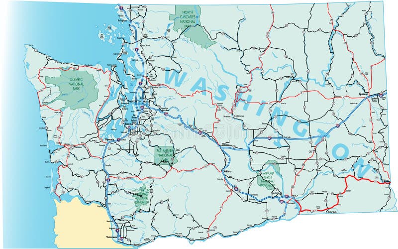
Free with trial Washington state road map with Interstates and U. S. Highways. All elements on 5 separate layers (State Fill, State Outline, Water, Roads, Cities) for easy editing. Map created November 26, 2008. ZIP File contains EPS-8 Adobe Illustrator file, Illustrator CS3 file, and large JPG file, 3508x5133. Source: Public domain National Planning Network ( and United S. Large cities vectors Washington State Road Map. With Interstates and U.S. Highways. All elements on 5 separate layers (State Fill, State Outline, Water, Roads, Cities) for. Washington state road map with Interstates and U.S. Highways. All elements on 5 separate layers (State Fill, State Outline, Water, Roads, Cities) for easy editing. Map created November 26, 2008. ZIP File contains EPS-8 Adobe Illustrator file, Illustrator CS3 file, and large JPG file, 3508x5133. Source: Public domain National Planning Network ( and United S
Free with trial Night World Map with largest cities. Triangular World Map with largest cities in the world. Large cities vectors Night World Map with largest cities. Triangular World Map with largest cities in the world
Free with trial All flags of the world in alphabetical order and Detailed world map with borders, countries, large cities. /. Large cities vectors All flags of the world in alphabetical order and Detailed world map with borders, countries, large cities. /
Free with trial US Cities. Vector set for you design. Large cities vectors US Cities. Vector set for you design
Free with trial Public transportation map of a large city, fictional vector art. Isolated on white background, free copy space. Large cities vectors Public transportation map of a large city, fictional vector art. Isolated on white background, free copy space
Free with trial Twe cities landscapes silhouettes. Illustration with two cities silhouettes isolated on white background. Large cities vectors Twe cities landscapes silhouettes. Illustration with two cities silhouettes isolated on white background
Free with trial Famous Places Lithuanian cities. Vector set of high-quality. Large cities vectors Famous Places Lithuanian cities. Vector set of high-quality
Free with trial Famous Places Italy cities. Set 2. Vector set of high-quality. Large cities vectors Famous Places Italy cities. Set 2. Famous Places Italy cities. Vector set of high-quality
Free with trial Famous Places cities in the UK. Kingston, Manchester, Leicester, Nottingham, Newcastle, York and Bristol. Set 2. Large cities vectors Famous Places cities in the UK. Kingston, Manchester, Leicester, Nottingham, Newcastle, York and Bristol. Set 2
Free with trial Brazil. Symbols of cities. For you design. Large cities vectors Brazil. Symbols of cities. For you design
Free with trial Cities in Chile. Famous Places Chilean cities. Large cities vectors Cities in Chile. Famous Places Chilean cities
Free with trial Famous Places cities in Germany. Bonn, Munster, Karlsruhe, Mannheim, Wiesbaden, Augsburg and Chemnitz. Set 4. Large cities vectors Famous Places cities in Germany. Bonn, Munster, Karlsruhe, Mannheim, Wiesbaden, Augsburg and Chemnitz. Set 4
Free with trial Cities in Ecuador. Famous Places Ecqador cities. Large cities vectors Cities in Ecuador. Famous Places Ecqador cities
Free with trial Famous Places Italy cities. Set 4. Vector set of high-quality. Large cities vectors Famous Places Italy cities. Set 4. Famous Places Italy cities. Vector set of high-quality. Set 4
Free with trial Cities in South Korea. Major korean cities famous places. Large cities vectors Cities in South Korea. Major korean cities famous places
Free with trial Famous Places of Estonian Cities. Vector set of high-quality. Large cities vectors Famous Places of Estonian Cities. Vector set of high-quality
Free with trial Political World Map Retro Colors - borders, countries and cities - Detailed World Map vector illustration - All elements are separated in editable layers clearly labeled - Vector. Large cities vectors Political World Map Retro Colors. Borders, countries and cities - Detailed World Map vector illustration - All elements are separated in editable layers. Political World Map Retro Colors - borders, countries and cities - Detailed World Map vector illustration - All elements are separated in editable layers clearly labeled - Vector
Free with trial Travelling plane. Abstract colorful illustration with various large city names written in the background, blue globe and passenger plane. Large cities vectors Travelling plane. Abstract colorful illustration with various large city names written in the background, blue globe and passenger plane. Travelling plane
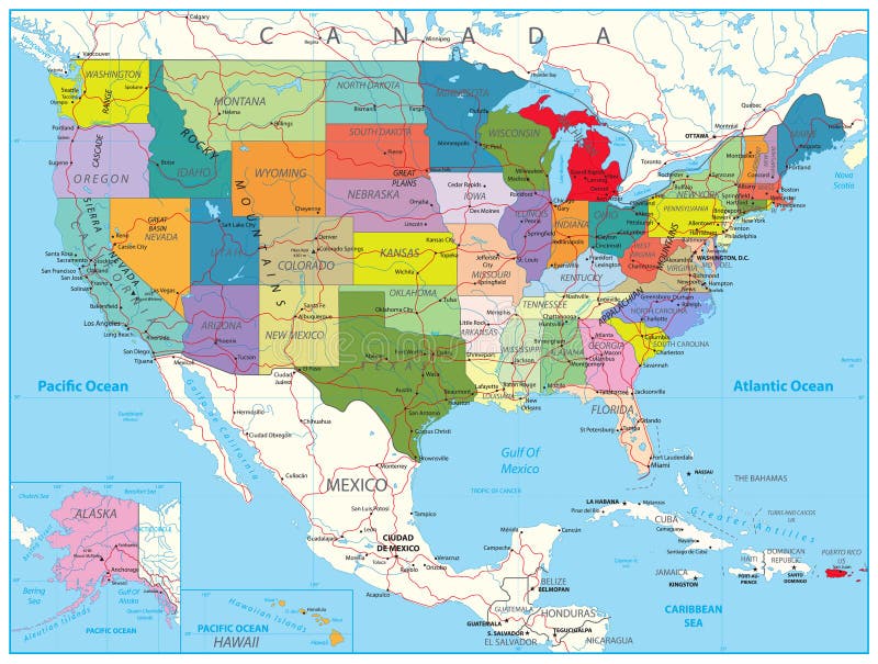
Free with trial USA Political Road Map with roads, water objects and cities. Large cities vectors USA Political Road Map. With roads, water objects and cities
Free with trial Paris, background with the Eiffel tower. Large cities vectors Paris, background with the Eiffel tower. France, Paris, background with the Eiffel tower
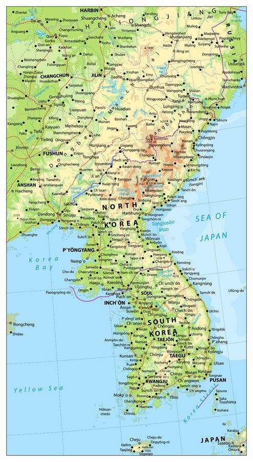
Free with trial Korean Peninsula large detailed physical map with roads, railroads, water objects, cities and capitals. Large cities vectors Korean Peninsula Map, Map Of North And South Korea. Korean Peninsula large detailed physical map with roads, railroads, water objects, cities and capitals. Korean Peninsula large detailed physical map with roads, railroads, water objects, cities and capitals.
Free with trial Cars. The card of Europe. Cars and businessman on a background the card of Europe. Large cities vectors Cars. The card of Europe. Cars and businessman on a background the card of Europe
Free with trial Large and detailed map of California - Plumas county. Large cities vectors California - Plumas county. Large and detailed map of California - Plumas county. Large and detailed map of California - Plumas county.
Free with trial Large and detailed map of California - Madera county. Large cities vectors California: Madera County. Large and detailed map of California - Madera county. Large and detailed map of California - Madera county.
Free with trial Large and detailed map of California - Orange county. Large cities vectors California - Orange county. Large and detailed map of California - Orange county. Large and detailed map of California - Orange county.
Free with trial Large and detailed map of California - Merced county. Large cities vectors California: Merced County. Large and detailed map of California - Merced county. Large and detailed map of California - Merced county.
Free with trial Large and detailed map of California - Monterey county. Large cities vectors California: Monterey County. Large and detailed map of California - Monterey county. Large and detailed map of California - Monterey county.
Free with trial Large and detailed map of California - Kings county. Large cities vectors California: Kings county map. Large and detailed map of California - Kings county. Large and detailed map of California - Kings county.
Free with trial California - Butte county map. Large and detailed map of California - Butte county. Large cities vectors California - Butte county map. Large and detailed map of California - Butte county
Free with trial Large and detailed map of California - Riverside county. Large cities vectors California - Riverside county. Large and detailed map of California - Riverside county. Large and detailed map of California - Riverside county.
Free with trial California - Fresno county map. Large and detailed map of California - Fresno county. Large cities vectors California - Fresno county map. Large and detailed map of California - Fresno county
Free with trial California - Humboldt county map. Large and detailed map of California - Humboldt county. Large cities vectors California - Humboldt county map. Large and detailed map of California - Humboldt county
Free with trial California - Calaveras county map. Large and detailed map of California - Calaveras county. Large cities vectors California - Calaveras county map. Large and detailed map of California - Calaveras county
Free with trial Large and detailed map of California - Los Angeles county. Large cities vectors California: Los Angeles county map. Large and detailed map of California - Los Angeles county. Large and detailed map of California - Los Angeles county.
Free with trial World capitals. Famous places of European cities. Large cities vectors World capitals. Famous places of European cities
Free with trial World capitals. Famous places of European cities. Large cities vectors World capitals. Famous places of European cities
Free with trial World capitals. Famous places of European cities. Large cities vectors World capitals. Famous places of European cities
Free with trial World capitals. Famous Places Asian Cities. Large cities vectors World capitals. Famous Places Asian Cities
Free with trial World capitals. Famous Places of American cities. Large cities vectors World capitals. Famous Places of American cities
Free with trial World capitals. Famous Places of American cities. Large cities vectors World capitals. Famous Places of American cities
Free with trial World capitals. Famous Places of American cities. Large cities vectors World capitals. Famous Places of American cities
Free with trial World capitals. Famous Places of American cities. Large cities vectors World capitals. Famous Places of American cities
Free with trial World capitals. Famous Places Asian Cities. Large cities vectors World capitals. Famous Places Asian Cities
Free with trial Печать. Cities in Hungary. Famous Places Hyngarian cities. Large cities vectors Печать. Cities in Hungary. Famous Places Hyngarian cities
Free with trial Virginia county map. A large and detailed map of the State of Virginia with all counties and county seats. Large cities vectors Virginia county map. A large and detailed map of the State of Virginia with all counties and county seats
Free with trial A large and detailed map of the State of Colorado with every county. Large cities vectors Colorado county map. A large and detailed map of the State of Colorado with every county. A large and detailed map of the State of Colorado with every county.
Free with trial Simple map of italy with largest cities. Vectorial illustration of Italy and its largest cities editable via eps. Large cities vectors Simple map of italy with largest cities. Vectorial illustration of Italy and its largest cities editable via eps
 Sign in