Free with trial State of Georgia. Map of Georgia state designed in illustration with the counties and the county seats. (Map is hight resolution. Macon vectors State of Georgia. Map of Georgia state designed in illustration with the counties and the county seats. (Map is hight resolution
Free with trial State of Georgia. Map of Georgia state designed in illustration with the counties and the county seats. (Map is hight resolution. Macon vectors State of Georgia. Map of Georgia state designed in illustration with the counties and the county seats. (Map is hight resolution
Free with trial Vector flag of Georgia state. United States of America. Macon vectors Vector flag of Georgia state. United States of America.
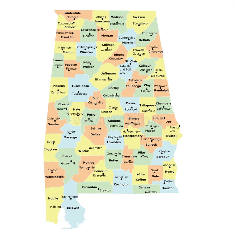
Free with trial Alabama county map. With 67 counties, county seats, and neighboring states. Macon vectors Alabama county map. With 67 counties, county seats, and neighboring states
Free with trial Vector flag of Georgia state. United States of America. Macon vectors Vector flag of Georgia state. United States of America.
Free with trial Georgia, GA, political map, with capital Atlanta and largest cities. State in the southeastern region of the United States of America. Peach State. Empire State of the South. Illustration. Vector. Macon vectors Georgia, GA, political map, Peach State, Empire State of the South. Georgia, GA, political map, with capital Atlanta and largest cities. State in the. Georgia, GA, political map, with capital Atlanta and largest cities. State in the southeastern region of the United States of America. Peach State. Empire State of the South. Illustration. Vector.
Free with trial Work and diy icon. Colored work and diy in hexagon icon in flat design style. Macon vectors Work and diy icon. Colored work and diy in hexagon icon in flat design style
Free with trial Vintage Touristic Greeting Card From Macon, Georgia - Vector EPS10. Grunge effects can be easily removed for a brand new, clean sign. Macon vectors Vintage Touristic Greeting Card From Macon, Georgia. Vintage Touristic Greeting Card From Macon, Georgia - Vector EPS10. Grunge effects can be easily removed. Vintage Touristic Greeting Card From Macon, Georgia - Vector EPS10. Grunge effects can be easily removed for a brand new, clean sign.
Free with trial Macon, Georgia - Cityscape with white abstract line corner curve modern style on dark blue background, building skyline city vector illustration design. Macon vectors Macon, Georgia - Cityscape with white abstract line corner curve modern style on dark blue background, building skyline city. Vector illustration design
Free with trial Georgia, GA, gray political map with capital Atlanta and largest cities. State in the southeastern region of the United States of America. Peach State. Empire State of the South. Illustration. Vector. Macon vectors Georgia, GA, gray political map, Peach State, Empire State of the South. Georgia, GA, gray political map with capital Atlanta and largest cities. State in the. Georgia, GA, gray political map with capital Atlanta and largest cities. State in the southeastern region of the United States of America. Peach State. Empire State of the South. Illustration. Vector
Free with trial Georgia state political map. Detailed map of Georgia state,in. vector format,with county borders and major. cities. Macon vectors Georgia state political map. Detailed map of Georgia state,in .vector format,with county borders and major .cities
Free with trial Georgia highly detailed physical map. Highly detailed physical map of the Georgia, in vector format,with all the relief forms,regions and big cities. Macon vectors Georgia highly detailed physical map. Highly detailed physical map of the Georgia, in vector format,with all the relief forms,regions and big cities
Free with trial Georgia road and highway map. Vector illustration. Macon vectors Georgia road and highway map. Vector illustration
Free with trial High detailed Georgia road map with labeling. Macon vectors Detailed Georgia road map with labeling. High detailed Georgia road map with labeling. High detailed Georgia road map with labeling.
Free with trial A Georgia State USA Quality Original Stamp Design. Vector Art Tourism Souvenir Round. Macon vectors Georgia State USA Quality Original Stamp Design. Vector Art Tourism Souvenir Round. A Georgia State USA Quality Original Stamp Design. Vector Art Tourism. A Georgia State USA Quality Original Stamp Design. Vector Art Tourism Souvenir Round.
Free with trial Diy and work icon. Colored icon in flat design style to illustrate tolls, work and diy in a house. Macon vectors Diy and work icon. Colored icon in flat design style to illustrate tolls, work and diy in a house
Free with trial US Georgia State Map with 159 counties and county seats. Each county is an individual object. Macon vectors Georgia County Map with 159 counties. US Georgia State Map with 159 counties and county seats. Each county is an individual object. US Georgia State Map with 159 counties and county seats. Each county is an individual object.
Free with trial A Georgia State USA Quality Original Stamp Design. Vector Art Tourism Souvenir Round. Macon vectors Georgia State USA Quality Original Stamp Design. Vector Art Tourism Souvenir Round. A Georgia State USA Quality Original Stamp Design. Vector Art Tourism. A Georgia State USA Quality Original Stamp Design. Vector Art Tourism Souvenir Round.
Free with trial Tuskegee Alabama with green background. Tuskegee Alabama United States of America with green background in best quality design. Macon vectors Tuskegee Alabama with green background. Tuskegee Alabama United States of America with green background in best quality design
Free with trial Map of state Georgia, USA. Vector set of Georgia state with roads map, cities and neighboring states. Macon vectors Map of state Georgia, USA. Vector set of Georgia state with roads map, cities and neighboring states
Free with trial Cherry blossom trees in macon vintage travel illustration design, water fountain outdoor in macon georgia. Macon vectors Cherry blossom trees in macon vintage travel illustration design, water fountain outdoor in macon georgia.
Free with trial Macon outline map. Macon (Illinois) blank outline map. Macon vectors Macon outline map. Macon (Illinois) blank outline map. Macon (Illinois) blank outline map
Free with trial Macon outline map. Macon (Mississippi) blank outline map. Macon vectors Macon outline map. Macon (Mississippi) blank outline map. Macon (Mississippi) blank outline map
Free with trial Macon county alabama state map silhouette outlines two variations filled black shape and dotted fill pattern graphic elements. Macon vectors Macon county alabama map silhouette outline and dotted fill vector illustration. Macon county alabama state map silhouette outlines two variations filled black. Macon county alabama state map silhouette outlines two variations filled black shape and dotted fill pattern graphic elements
Free with trial Macon outline map. Macon (Missouri) blank outline map. Macon vectors Macon outline map. Macon (Missouri) blank outline map. Macon (Missouri) blank outline map
Free with trial Macon outline map. Macon County (Missouri) blank outline map. Macon vectors Macon outline map. Macon County (Missouri) blank outline map. Macon County (Missouri) blank outline map
Free with trial Macon outline map. Macon County (North Carolina) blank outline map. Macon vectors Macon outline map. Macon County (North Carolina) blank outline map. Macon County (North Carolina) blank outline map
Free with trial Macon outline map. Macon arrondissement outline map set. Macon vectors Macon outline map. Macon arrondissement outline map set
Free with trial Map of the County Macon (Tennessee, United States). Symbol Map of the County Macon (Tennessee, US) showing the County with a few black horizontal lines. Macon vectors Map of the County Macon (Tennessee, United States). Symbol Map of the County Macon (Tennessee, US) showing the County with a few black horizontal lines
Free with trial Map of the County Macon (Missouri, United States). Symbol Map of the County Macon (Missouri, US) showing the County with a few black horizontal lines. Macon vectors Map of the County Macon (Missouri, United States). Symbol Map of the County Macon (Missouri, US) showing the County with a few black horizontal lines
Free with trial Large and detailed map of Macon County in Georgia, USA. Macon vectors Large and detailed map of Macon County in Georgia. USA
Free with trial Map of the County Macon (North Carolina, United States). Symbol Map of the County Macon (North Carolina, US) showing the County with a few black horizontal lines. Macon vectors Map of the County Macon (North Carolina, United States). Symbol Map of the County Macon (North Carolina, US) showing the County with a few black horizontal lines
Free with trial Map of the County Macon (Alabama, United States). Symbol Map of the County Macon (Alabama, US) showing the County with a few black horizontal lines. Macon vectors Map of the County Macon (Alabama, United States). Symbol Map of the County Macon (Alabama, US) showing the County with a few black horizontal lines
Free with trial Map of the County Macon (Georgia, United States). Symbol Map of the County Macon (Georgia, US) showing the County with a few black horizontal lines. Macon vectors Map of the County Macon (Georgia, United States). Symbol Map of the County Macon (Georgia, US) showing the County with a few black horizontal lines
Free with trial Map of the County Macon (Georgia, United States). Symbol Map Of the County Macon (Georgia, US) showing the County with a few black dots. Macon vectors Map of the County Macon (Georgia, United States). Symbol Map Of the County Macon (Georgia, US) showing the County with a few black dots
Free with trial Map of the County Macon (Alabama, United States). Symbol Map Of the County Macon (Alabama, US) showing the County with a few black dots. Macon vectors Map of the County Macon (Alabama, United States). Symbol Map Of the County Macon (Alabama, US) showing the County with a few black dots
Free with trial Map of the County Macon (Alabama, United States). Symbol Map Of the County Macon (Alabama, US) showing the County with a few black dots. Macon vectors Map of the County Macon (Alabama, United States). Symbol Map Of the County Macon (Alabama, US) showing the County with a few black dots
Free with trial Map of the County Macon (Georgia, United States). Symbol Map Of the County Macon (Georgia, US) showing the County with a few black dots. Macon vectors Map of the County Macon (Georgia, United States). Symbol Map Of the County Macon (Georgia, US) showing the County with a few black dots
Free with trial Map of the County Macon (Illinois, United States). Symbol Map Of the County Macon (Illinois, US) showing the County with a few black dots. Macon vectors Map of the County Macon (Illinois, United States). Symbol Map Of the County Macon (Illinois, US) showing the County with a few black dots
Free with trial Macon outline map. Macon County (Missouri) blank outline map. Macon vectors Macon outline map. Macon County (Missouri) blank outline map. Macon County (Missouri) blank outline map
Free with trial Macon outline map. Macon County (Alabama) blank outline map. Macon vectors Macon outline map. Macon County (Alabama) blank outline map. Macon County (Alabama) blank outline map
Free with trial Macon outline map. Macon County (Illinois) blank outline map. Macon vectors Macon outline map. Macon County (Illinois) blank outline map. Macon County (Illinois) blank outline map
Free with trial Macon outline map. Macon County (Illinois) blank outline map. Macon vectors Macon outline map. Macon County (Illinois) blank outline map. Macon County (Illinois) blank outline map
Free with trial Macon outline map. Macon County (Tennessee) blank outline map. Macon vectors Macon outline map. Macon County (Tennessee) blank outline map. Macon County (Tennessee) blank outline map
Free with trial Detailed infographic and map of Macon County in Georgia. USA. Macon vectors Detailed infographic and map of Macon County in Georgia. USA
Free with trial Large and detailed map of Macon County in Georgia. USA. Macon vectors Large and detailed map of Macon County in Georgia. USA
Free with trial Macon outline map. Macon County (Tennessee) outline map set. Macon vectors Macon outline map. Macon County (Tennessee) outline map set. Macon County (Tennessee) outline map set
Free with trial Macon vector minimalist street map American city on grunge dark grey background. Georgia. USA. Macon vectors Macon vector minimalist street map American city on grunge dark background. Georgia. USA. Macon vector minimalist street map American city on grunge dark grey. Macon vector minimalist street map American city on grunge dark grey background. Georgia. USA
Free with trial Macon-Bibb County outline map. Macon-Bibb County (Georgia) blank outline map. Macon vectors Macon-Bibb County outline map. Macon-Bibb County (Georgia) blank outline map. Macon-Bibb County (Georgia) blank outline map
Free with trial Map of Macon County in Georgia, USA. Arranged in a circle. Macon vectors Map of Macon County in Georgia, USA. Arranged in a circle
Free with trial Macon outline map. Macon County (North Carolina) blank outline map. Macon vectors Macon outline map. Macon County (North Carolina) blank outline map. Macon County (North Carolina) blank outline map
Free with trial Macon outline map. Macon County (Alabama) outline map set. Macon vectors Macon outline map. Macon County (Alabama) outline map set. Macon County (Alabama) outline map set
Free with trial Map of Macon County in Alabama USA. Detailed infographic and map of Macon County in Alabama USA. Macon vectors Map of Macon County in Alabama USA. Detailed infographic and map of Macon County in Alabama USA
Free with trial Map of the County Macon (Illinois, United States). Symbol Map Of the County Macon (Illinois, US) showing the County with a few black dots. Macon vectors Map of the County Macon (Illinois, United States). Symbol Map Of the County Macon (Illinois, US) showing the County with a few black dots
Free with trial Map of the County Macon (Illinois, United States). Symbol Map of the County Macon (Illinois, US) showing the County with a few black horizontal lines. Macon vectors Map of the County Macon (Illinois, United States). Symbol Map of the County Macon (Illinois, US) showing the County with a few black horizontal lines
Free with trial Symbol Map of Macon-Bibb County (Georgia, United States). Showing the village or settlement with a pattern of just a few black horizontal lines. Macon vectors Symbol Map of Macon-Bibb County (Georgia, United States). Showing the village or settlement with a pattern of just a few black horizontal lines
Free with trial Printable downtown road map poster of the USA city of MACON-BIBB on solid white background with city name. Macon vectors Poster print road map of the American city of MACON-BIBB. Printable downtown road map poster of the USA city of MACON-BIBB on solid white background with city. Printable downtown road map poster of the USA city of MACON-BIBB on solid white background with city name
Free with trial State of Georgia, political map. State in the Southeastern, South Atlantic, and Deep South regions of United States, with capital Atlanta, bordering the Atlantic Ocean. Isolated illustration. Vector. Macon vectors State of Georgia, United States, political map with largest cities. State of Georgia, political map. State in the Southeastern, South Atlantic, and Deep South. State of Georgia, political map. State in the Southeastern, South Atlantic, and Deep South regions of United States, with capital Atlanta, bordering the Atlantic Ocean. Isolated illustration. Vector
Free with trial Georgia, U. S. state, subdivided into 159 counties, multi colored political map with capital Atlanta, borders and county names. State in the Southeastern region of the United States. The Peach State. Macon vectors Georgia, U.S. state, subdivided into 159 counties, multi colored map. Georgia, U.S. state, subdivided into 159 counties, multi colored political map with capital. Georgia, U.S. state, subdivided into 159 counties, multi colored political map with capital Atlanta, borders and county names. State in the Southeastern region of the United States. The Peach State.
Free with trial Georgia counties, gray political map. State in the Southeastern region of the United States, subdivided into 159 counties. Nicknamed Peach State, and Empire State of the South. Map with county names. Macon vectors Georgia, U.S. state, subdivided into 159 counties, gray political map. Georgia counties, gray political map. State in the Southeastern region of the United. Georgia counties, gray political map. State in the Southeastern region of the United States, subdivided into 159 counties. Nicknamed Peach State, and Empire State of the South. Map with county names.
Free with trial Georgia counties, political map. State in the Southeastern region of the United States, subdivided into 159 counties. Nicknamed Peach State, and Empire State of the South. Map with county names. Macon vectors Georgia, U.S. state, subdivided into 159 counties, political map. Georgia counties, political map. State in the Southeastern region of the United States. Georgia counties, political map. State in the Southeastern region of the United States, subdivided into 159 counties. Nicknamed Peach State, and Empire State of the South. Map with county names.
Free with trial Map of Georgia, GA. Georgia, GA - US state. Thin black outline silhouette isolated on white background. Vector illustration. Macon vectors Map of Georgia, GA. Georgia, GA - US state. Thin black outline silhouette isolated on white background. Vector illustration
Free with trial Georgia, GA - detailed political map of US state. Administrative map divided into counties. Blue map with county name labels. Vector illustration. Macon vectors Administrative Map of Georgia, GA. Georgia, GA - detailed political map of US state. Administrative map divided into counties. Blue map with county name labels. Georgia, GA - detailed political map of US state. Administrative map divided into counties. Blue map with county name labels. Vector illustration
Free with trial Map of Georgia, GA. Georgia, GA - grey silhouette map of US state. Vector illustration. Macon vectors Map of Georgia, GA. Georgia, GA - grey silhouette map of US state. Vector illustration
Free with trial Georgia, GA - detailed political map of US state. Administrative map divided into counties. Thin black outline map with county name labels. Vector illustration. Macon vectors Administrative Map of Georgia, GA. Georgia, GA - detailed political map of US state. Administrative map divided into counties. Thin black outline map with county. Georgia, GA - detailed political map of US state. Administrative map divided into counties. Thin black outline map with county name labels. Vector illustration
Free with trial Georgia ga state map outline simplified. Georgia GA state shape map outline simplified USA vector isolated on white background. Macon vectors Georgia ga state map outline simplified. Georgia GA state shape map outline simplified USA vector isolated on white background
Free with trial Georgia ga state map silhouette simplified. Georgia GA state shape map silhouette outline simplified USA vector isolated on white background. Macon vectors Georgia ga state map silhouette simplified. Georgia GA state shape map silhouette outline simplified USA vector isolated on white background
Free with trial Map of Bibb County in Georgia, USA. Arranged in a circle. Macon vectors Map of Bibb County in Georgia, USA. Arranged in a circle
Free with trial Map of Bibb County in Georgia USA. Detailed infographic and map of Bibb County in Georgia USA. Macon vectors Map of Bibb County in Georgia USA. Detailed infographic and map of Bibb County in Georgia USA
Free with trial Large and detailed map of Bibb County in Georgia USA. Macon vectors Large and detailed map of Bibb County in Georgia. Large and detailed map of Bibb County in Georgia USA. Large and detailed map of Bibb County in Georgia USA.
Free with trial Georgia state circle flag. Part of The United States of America. Clean design for print, web, or educational use. Vector illustration with dropped shadow on white background. Macon vectors Georgia - circle flag of state of USA. Georgia state circle flag. Part of The United States of America. Clean design for print, web, or educational use. Vector. Georgia state circle flag. Part of The United States of America. Clean design for print, web, or educational use. Vector illustration with dropped shadow on white background.
Free with trial Georgia official state flag. Part of The United States of America. Clean design for print, web, or educational use. Vector illustration. Macon vectors Georgia - flag of state of USA. Georgia official state flag. Part of The United States of America. Clean design for print, web, or educational use. Vector. Georgia official state flag. Part of The United States of America. Clean design for print, web, or educational use. Vector illustration.
Free with trial Georgia state flag 3-2 ratio. Part of The United States of America. Clean design for print, web, or educational use. Vector illustration. Macon vectors Georgia - flag of state of USA. Georgia state flag 3-2 ratio. Part of The United States of America. Clean design for print, web, or educational use. Vector. Georgia state flag 3-2 ratio. Part of The United States of America. Clean design for print, web, or educational use. Vector illustration.
Free with trial Georgia ga flag flying. Accurate correct georgia ga state flag flying waving flowing vector isolated on white background. Macon vectors Georgia ga flag flying. Accurate correct georgia ga state flag flying waving flowing vector isolated on white background
Free with trial Georgia ga state flag in love heart shape. Symbol vector isolated on white background. Macon vectors Georgia ga state flag in love heart shape. Symbol vector isolated on white background
Free with trial Georgia flag flying on flagpole. Accurate correct georgia ga state flag flying waving flowing flying on flagpole vector isolated on white background. Macon vectors Georgia flag flying on flagpole. Accurate correct georgia ga state flag flying waving flowing flying on flagpole vector isolated on white background
Free with trial Accurate correct georgia ga state flag flying. Waving flowing vector isolated on white background. Macon vectors Accurate correct georgia ga state flag flying. Waving flowing vector isolated on white background
Free with trial Georgia GA state shape map shape simplified with USA american flag black and white vector isolated on white background. Macon vectors Georgia state shape with usa flag black white. Georgia GA state shape map shape simplified with USA american flag black and white vector isolated on white. Georgia GA state shape map shape simplified with USA american flag black and white vector isolated on white background
Free with trial Georgia ga state map shape with flag. Georgia GA state shape map simplified with georgian USA flag vector isolated on white background. Macon vectors Georgia ga state map shape with flag. Georgia GA state shape map simplified with georgian USA flag vector isolated on white background
Free with trial Cool aviator sunglasses with georgia state flag. Cool simple Aviator Sunglasses with Georgia GA state flag in lenses tshirt design graphic vector. Macon vectors Cool aviator sunglasses with georgia state flag. Cool simple Aviator Sunglasses with Georgia GA state flag in lenses tshirt design graphic vector
 Sign in