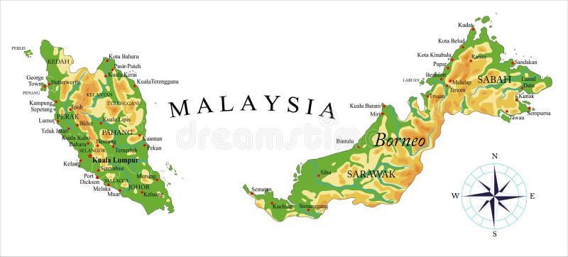
Free with trial Highly detailed physical map of Malaysia,in vector format,with all the relief forms,regions and big cities. Malacca vectors Malaysia physical map. Highly detailed physical map of Malaysia,in vector format,with all the relief forms,regions and big cities. Highly detailed physical map of Malaysia,in vector format,with all the relief forms,regions and big cities.
Free with trial Amla fruit vector illustration. Phyllanthus emblica, emblic myrobalan, myrobalan, Indian gooseberry, Malacca tree, or amalika. Edible fruit. Used in medicine, culinary, inks shampoos hair oil. Malacca vectors Amla Fruit Vector Illustration Phyllanthus Emblica. Amla fruit vector illustration. Phyllanthus emblica, emblic myrobalan, myrobalan, Indian gooseberry, Malacca. Amla fruit vector illustration. Phyllanthus emblica, emblic myrobalan, myrobalan, Indian gooseberry, Malacca tree, or amalika. Edible fruit. Used in medicine, culinary, inks shampoos hair oil
Free with trial Thailand map. Highly detailed vector map of thailand with administrative divisions,main cities and roads. Malacca vectors Thailand map. Highly detailed vector map of thailand with administrative divisions,main cities and roads
Free with trial Indo-Pacific major energy SLOCs, political map. Geopolitically critical Sea Lines Of Communication. Primary maritime routes between ports, used for trade, logistics and naval forces. Illustration. Malacca vectors Indo-Pacific major energy SLOCs, Sea Lines Of Communication, map. Indo-Pacific major energy SLOCs, political map. Geopolitically critical Sea Lines Of. Indo-Pacific major energy SLOCs, political map. Geopolitically critical Sea Lines Of Communication. Primary maritime routes between ports, used for trade, logistics and naval forces. Illustration.
Free with trial Road map of the indonesian island sumatra. Malacca vectors Road map of the indonesian island sumatra.
Free with trial Administrative structure vector map of the Malay Peninsula, Malaysia. Malacca vectors Administrative structure vector map of the Malay Peninsula, Malaysia.
Free with trial Sixteen flags the States of Malaysia - alphabetical order with name. Set of 3d geolocation signs like flags States of Malaysia. Sixteen 3d geolocation signs for your design. EPS10. Malacca vectors Sixteen flags the States of Malaysia - alphabetical order with name. Set of 3d geolocation signs like flags States of Malaysia. Sixteen 3d geolocation. Sixteen flags the States of Malaysia - alphabetical order with name. Set of 3d geolocation signs like flags States of Malaysia. Sixteen 3d geolocation signs for your design. EPS10
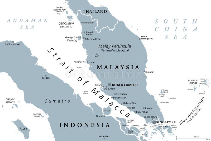
Free with trial Strait of Malacca,gray political map. Important shipping lane and a main shipping channel between Malay Peninsula (Peninsular Malaysia) and Sumatra (Indonesia) connecting Andaman and South China Sea. Malacca vectors Strait of Malacca, a main shipping channel and lane, gray political map. Strait of Malacca,gray political map. Important shipping lane and a main shipping. Strait of Malacca,gray political map. Important shipping lane and a main shipping channel between Malay Peninsula (Peninsular Malaysia) and Sumatra (Indonesia) connecting Andaman and South China Sea.
Free with trial Malacca map vector. Malacca States and federal territories of Malaysia, Federation of Malaysia map vector illustration, scribble sketch Malacca State map. Malacca vectors Malacca map vector. Malacca States and federal territories of Malaysia, Federation of Malaysia map vector illustration, scribble sketch Malacca State map
Free with trial Gooseberry seamless vector pattern. Indian gooseberry Malacca tree, or gooseberry. Edible fruit. Good for backdrop, textile, wrapping paper, wall posters. Continuous line drawing. Malacca vectors Gooseberry seamless vector pattern. Indian gooseberry Malacca tree, or gooseberry. Edible fruit. Good for backdrop, textile. Wrapping paper, wall posters. Gooseberry seamless vector pattern. Indian gooseberry Malacca tree, or gooseberry. Edible fruit. Good for backdrop, textile, wrapping paper, wall posters. Continuous line drawing.
Free with trial Flag Malacca brush strokes. Waving Flag of Malacca State on transparent background. For your web site design, app, UI. Malaysia. EPS10. Malacca vectors Flag Malacca brush strokes. Waving Flag of Malacca State on transparent background. For your web site design, app, UI. Malaysia. EPS10
Free with trial Flag of Historic State of Malacca (Malaysia) Melaka,. Two equal bands of red and white, with a yellow crescent and five-pointed star in a blue canton. Malacca vectors Flag of Historic State of Malacca (Malaysia) Melaka,. Two equal bands of red and white, with a yellow crescent and five-pointed star in a blue canton
Free with trial Penang, a state of Malaysia in Southeast Asia, gray political map. Located on the coast of Peninsular Malaysia along Strait of Malacca in the Andaman Sea, with capital George Town on Penang Island. Malacca vectors Penang, a state of Malaysia in Southeast Asia, gray political map. Located on the coast of Peninsular Malaysia along Strait of Malacca in the Andaman Sea, with
Free with trial Phuket, largest Island of Thailand, political map with surrounding area. Popular tourist region with plenty of islands, south of Malay Peninsula, in the Andaman Sea and north of the Strait of Malacca. Malacca vectors Phuket, largest Island of Thailand, political map with surrounding area. Popular tourist region with plenty of islands, south of Malay Peninsula, in the
Free with trial Phuket, largest Island of Thailand, gray political map, with surrounding area. Popular tourist region, with plenty of islands, south of Malay Peninsula, in the Andaman Sea, north of Strait of Malacca. Malacca vectors Phuket, largest Island of Thailand, gray political map, with surrounding area. Popular tourist region, with plenty of islands, south of Malay Peninsula, in the
Free with trial A detailed map illustrating major global shipping routes, highlighting key straits and canals such as the Strait of Hormuz, Strait of Malacca, Suez Canal, and Panama Canal. The map features cargo ships navigating through these critical waterways, emphasizing their importance in international trade and commerce. Malacca vectors Global Shipping Routes Map. A detailed map illustrating major global shipping routes, highlighting key straits and canals such as the Strait of Hormuz, Strait of. A detailed map illustrating major global shipping routes, highlighting key straits and canals such as the Strait of Hormuz, Strait of Malacca, Suez Canal, and Panama Canal. The map features cargo ships navigating through these critical waterways, emphasizing their importance in international trade and commerce.
Free with trial Indian gooseberry Phyllanthus emblica , or emblic myrobalan, robalan, Malacca tree, amla with leaves and berries. Hand drawn botanical vector illustration. Malacca vectors Indian gooseberry Phyllanthus emblica , or emblic myrobalan, robalan, Malacca tree, amla with leaves and berries. Hand drawn botanical vector illustration
Free with trial Indian gooseberry Phyllanthus emblica , or emblic myrobalan, robalan, Malacca tree, amla with leaves and berries. Hand drawn botanical vector illustration. Malacca vectors Indian gooseberry Phyllanthus emblica , or emblic myrobalan, robalan, Malacca tree, amla with leaves and berries. Hand drawn botanical vector illustration
Free with trial North Indian Ocean, gray political map with countries, international borders, and capitals. Tropical marine region, comprising Arabian Sea to the west of India and Bay of Bengal to the east. Vector. Malacca vectors North Indian Ocean, gray political map. With countries, international borders, and capitals. Tropical marine region, comprising Arabian Sea to the west of India. North Indian Ocean, gray political map with countries, international borders, and capitals. Tropical marine region, comprising Arabian Sea to the west of India and Bay of Bengal to the east. Vector
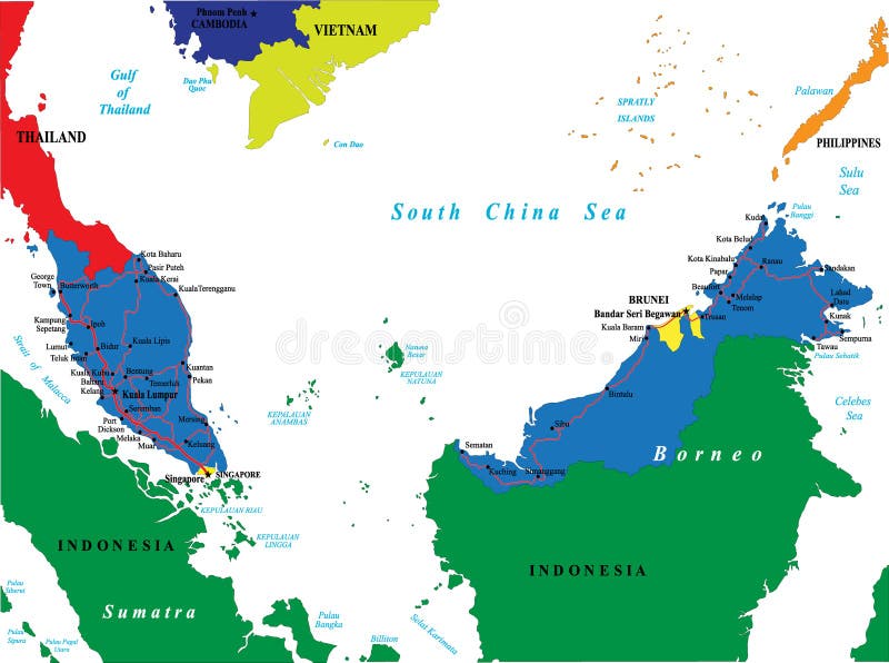
Free with trial Highly detailed vector map of Malaysia with main cities and roads. Malacca vectors Malaysia map. Highly detailed vector map of Malaysia with main cities and roads. Highly detailed vector map of Malaysia with main cities and roads.
Free with trial Thailand Political Map with capital Bangkok, national borders, most important cities, rivers and lakes. English labeling and scaling. Illustration. Malacca vectors Thailand Political Map. With capital Bangkok, national borders, most important cities, rivers and lakes. English labeling and scaling. Illustration
Free with trial Malaysia political map with capital Kuala Lumpur, national borders, important cities and rivers. English labeling and scaling. Illustration. Malacca vectors Malaysia Political Map. With capital Kuala Lumpur, national borders, important cities and rivers. English labeling and scaling. Illustration
Free with trial Northern part of Mainland Southeast Asia, transport political map. Countries Thailand, Vietnam, Myanmar, Laos, and Cambodia, with the most important waterways on rivers, and with the largest cities. Malacca vectors Northern part of Mainland Southeast Asia, transport political map. Countries Thailand, Vietnam, Myanmar, Laos, and Cambodia, with the most important waterways
Free with trial Malaysia country detailed editable map. With regions cities and towns, roads and railways, geographic sites. Vector EPS-10 file. Malacca vectors Malaysia country detailed editable map. With regions cities and towns, roads and railways, geographic sites. Vector EPS-10 file
Free with trial Cartoon Gooseberry character. Happy Fruit and Berry symbol. Eco food icon. Design element for children`s coloring book, kids t-shirt print, logo, labels, patches or stickers. Malacca vectors Cartoon Gooseberry character. Happy Fruit and Berry symbol. Eco food icon. Design element for children`s coloring book, kids t-shirt print, logo, labels
Free with trial Using concrete piling finished compressed into the soil by driven pile machine. Malacca vectors Driven pile construction method. Using concrete piling finished compressed into the soil by driven pile machine. Using concrete piling finished compressed into the soil by driven pile machine.
Free with trial Bay of Bengal, gray political map. Northeastern part of Indian Ocean and largest bay of the world, positioned between the Indian subcontinent and Indochinese peninsula, located below Bengal region. Malacca vectors Bay of Bengal, northeastern part of Indian Ocean, gray political map. Bay of Bengal, gray political map. Northeastern part of Indian Ocean and largest bay of the. Bay of Bengal, gray political map. Northeastern part of Indian Ocean and largest bay of the world, positioned between the Indian subcontinent and Indochinese peninsula, located below Bengal region.
Free with trial Amalaki plant black and white doodle seamless background. Amla fruits. Hand drawing pattern in vector for textile, fabric, wrapping paper, coloring book. Malacca vectors Amla doodle seamless pattern. Amalaki plant black and white doodle seamless background. Amla fruits. Hand drawing pattern in vector for textile, fabric, wrapping. Amalaki plant black and white doodle seamless background. Amla fruits. Hand drawing pattern in vector for textile, fabric, wrapping paper, coloring book
Free with trial Indonesia, a country in Southeast Asia and Oceania, gray political map. Republic and archipelago with capital Jakarta, and largest islands Sumatra, Java, Sulawesi, and parts of Borneo and New Guinea. Malacca vectors Indonesia, a country in Southeast Asia and Oceania, gray political map. Republic and archipelago with capital Jakarta, and largest islands Sumatra, Java
Free with trial Administrative vector map of the Indonesian province of West Sumatra, Sumatra, Indonesia. Malacca vectors Administrative vector map of the Indonesian province of West Sumatra, Sumatra, Indonesia.
Free with trial Administrative vector map of the Indonesian province of Aceh, Sumatra, Indonesia. Malacca vectors Administrative vector map of the Indonesian province of Aceh, Sumatra, Indonesia.
Free with trial Thailand political map, from Ko Tao and Ko Samui to Phuket and Phi Phi Islands. Travel destinations west and east of Malay Peninsula, off the coast of Thailand, with most important islands and cities. Malacca vectors Thailand political map, from Ko Tao and Ko Samui to Phuket. And Phi Phi Islands. Travel destinations west and east of Malay Peninsula, off the coast of Thailand. Thailand political map, from Ko Tao and Ko Samui to Phuket and Phi Phi Islands. Travel destinations west and east of Malay Peninsula, off the coast of Thailand, with most important islands and cities.
Free with trial Administrative vector map of the Indonesian province of North Sumatra, Sumatra, Indonesia,. Malacca vectors Administrative vector map of the Indonesian province of North Sumatra, Sumatra, Indonesia.
Free with trial Bay of Bengal, political map. Northeastern part of the Indian Ocean and largest bay of the world, positioned between the Indian subcontinent and Indochinese peninsula, located below the Bengal region. Malacca vectors Bay of Bengal, northeastern part of the Indian Ocean, political map. Bay of Bengal, political map. Northeastern part of the Indian Ocean and largest bay of the. Bay of Bengal, political map. Northeastern part of the Indian Ocean and largest bay of the world, positioned between the Indian subcontinent and Indochinese peninsula, located below the Bengal region.
Free with trial 3D map template for website pattern, annual report, info graphics. Travel worldwide, map silhouette backdrop. Malacca vectors Langkawi island topography map contour vector isolated on white background. 3D map template for website pattern, annual report, info graphics. Travel worldwide. 3D map template for website pattern, annual report, info graphics. Travel worldwide, map silhouette backdrop.
Free with trial Fruits, Illustration of Hand Drawn Sketch Frame of Manila Tamarind and Gooseberry Isolated on White Background. Malacca vectors Hand Drawn Frame of Manila Tamarind and Gooseberry Fruit. Fruits, Illustration of Hand Drawn Sketch Frame of Manila Tamarind and Gooseberry Isolated on White. Fruits, Illustration of Hand Drawn Sketch Frame of Manila Tamarind and Gooseberry Isolated on White Background.
Free with trial Tropical Fruits, Illustration of Hand Drawn Sketch Fresh Indian Gooseberry Isolated on White Background. Malacca vectors Hand Drawn of Indian Gooseberry on White Background. Tropical Fruits, Illustration of Hand Drawn Sketch Fresh Indian Gooseberry Isolated on White Background. Tropical Fruits, Illustration of Hand Drawn Sketch Fresh Indian Gooseberry Isolated on White Background.
Free with trial Three realistic 3d amla or Indian gooseberry mockup with green leaf. Isolated on white background. Illustrated vector. Malacca vectors Three realistic 3d amla or Indian gooseberry mockup with green leaf. Isolated on white background. Illustrated vector
Free with trial Malaysia higt detailed map with subdivisions. Administrative map of Malaysia with districts and cities name, colored by states and administrative districts. Vector illustration. Malacca vectors Malaysia higt detailed map with subdivisions. Administrative map of Malaysia with districts and cities name, colored by states and. Administrative districts
Free with trial Blank map of Malaysia. High quality map of Malaysia with provinces on transparent background for your web site design, logo, app, UI. Asia. Stock vector. EPS10. Malacca vectors Blank map of Malaysia. High quality map of Malaysia with provinces on transparent background for your web site design, logo, app,. UI. Asia. Stock vector
Free with trial Medicinal herbs collection. Vector hand drawn illustration of plants phyllanthus emblica and terminalia arjuna. Malacca vectors Illustration of plants phyllanthus emblica and terminalia arjuna. Medicinal herbs collection. Vector hand drawn illustration of plants phyllanthus emblica and. Medicinal herbs collection. Vector hand drawn illustration of plants phyllanthus emblica and terminalia arjuna
Free with trial Panorama chinese street with old houses, chinese arch, lanterns and a garland. Vector illustration of city street in cartoon style. Malacca vectors Panorama chinese street with old houses, chinese arch, lanterns and a garland. Vector illustration of city street in cartoon style.
Free with trial Panorama chinese street with old houses, chinese arch, lanterns and a garland. Vector illustration of city street in cartoon style. Malacca vectors Panorama chinese street with old houses, chinese arch, lanterns and a garland. Vector illustration of city street in cartoon style.
Free with trial Chinese street restaurant building for town set. Cartoon japan shop and asian district cityscape isolated vintage business clipart decoration collection for cityscape exterior. Historic kiosk place. Malacca vectors Chinese street restaurant building for town set. Cartoon japan shop and asian district cityscape isolated vintage business clipart decoration collection for
Free with trial Amla, castor and jojoba oil in different glass vials. Various bottles with corks. Indian gooseberry frut. Seeds and ricinus beans. Plant extract for cosmetology. Elixir or serum,lotion for hair and nails. Malacca vectors Amla, castor and jojoba oil in different glass vials. Various bottles with corks.Indian gooseberry frut.Seeds and ricinus beans. Plant extract for cosmetology. Amla, castor and jojoba oil in different glass vials. Various bottles with corks.Indian gooseberry frut.Seeds and ricinus beans.Plant extract for cosmetology.Elixir or serum,lotion for hair and nails
Free with trial Old historical houses on the river in Melaka, Malaysia. Travel sketch. Vintage touristic hand drawn postcard, poster, book illustration in vector. Malacca vectors Melaka, Malaysia, Southeast Asia. Colonial buildings. Travel sketch. Vintage touristic hand drawn postcard in vector. Old historical houses on the river in. Old historical houses on the river in Melaka, Malaysia. Travel sketch. Vintage touristic hand drawn postcard, poster, book illustration in vector
Free with trial Tourism in Malaysia Truly Asia Illustration. Woman Standing At Petronas Tower Represented Tourism in Malaysia Truly Asia Illustration. Malacca vectors Tourism in Malaysia Truly Asia Illustration. Woman Standing At Petronas Tower Represented Tourism in Malaysia Truly Asia Illustration
Free with trial Circular icons representing the flags of Malaysian states and federal territories. The image includes flags for Malaysia, Perlis, Penang, Kedah, Perak, Selangor, Negeri Sembilan, Malacca, Johor, Pahang, Terengganu, Kelantan, Sabah, and Sarawak, along with federal territories Kuala Lumpur, Putrajaya, and Labuan. Each icon features distinct designs and colors symbolic of each state's identity, including elements like stripes, crescents, stars, and color patterns. All are arranged in a grid format with labels below each icon for identification. Malacca vectors Malaysia state flag circle icon collection. Circular icons representing the flags of Malaysian states and federal territories. The image includes flags for. Circular icons representing the flags of Malaysian states and federal territories. The image includes flags for Malaysia, Perlis, Penang, Kedah, Perak, Selangor, Negeri Sembilan, Malacca, Johor, Pahang, Terengganu, Kelantan, Sabah, and Sarawak, along with federal territories Kuala Lumpur, Putrajaya, and Labuan. Each icon features distinct designs and colors symbolic of each state's identity, including elements like stripes, crescents, stars, and color patterns. All are arranged in a grid format with labels below each icon for identification.
Free with trial Malaysia State Flags Circle Button Icon Set. Malacca vectors Malaysia State Flags Circle Button Icon Set.
Free with trial Flag of Johor State. Vector Illustration of the Malaysian State of Johor Flag. Malacca vectors Flag of Johor State. Vector Illustration of the Malaysian State of Johor Flag
Free with trial Location Map of Kelantan State. Black Location Map of the Malaysian State of Kelantan within Grey Map of Malaysia. Malacca vectors Location Map of Kelantan State. Black Location Map of the Malaysian State of Kelantan within Grey Map of Malaysia
Free with trial Malaysia State Flag Circle Icon Set. Malaysia State Flags rectangle Button Icon Set for Asian concept. Malacca vectors Malaysia State Flag Circle Icon Set. Malaysia State Flags rectangle Button Icon Set for Asian concept
Free with trial Flag of Malaysia. Vector illustration on a white background. Brush strokes are drawn by hand. Independence Day. Malacca vectors Flag of Malaysia. Vector illustration on a white background. Brush strokes are drawn by hand. Independence Day
Free with trial Sixteen flags the States of Malaysia- alphabetical order with name. Set of 2d geolocation signs like flags States of Malaysia. Sixteen 2d geolocation signs for your design. EPS10. Malacca vectors Sixteen flags the States of Malaysia- alphabetical order with name. Set of 2d geolocation signs like flags States of Malaysia. Sixteen 2d geolocation signs
Free with trial Flag Perak brush strokes. Waving Flag of Perak State on transparent background. For your web site design, app, UI. Malaysia. EPS10. Malacca vectors Flag Perak brush strokes. Waving Flag of Perak State on transparent background. For your web site design, app, UI. Malaysia. EPS10
Free with trial Singapore and southern Strait of Malacca, gray political map. Malacca Strait and Singapore Strait connecting Indian Ocean with South China Sea, a geostrategic choke point for global shipping. Vector. Malacca vectors Singapore and southern Strait of Malacca, gray political map. Malacca Strait and Singapore Strait connecting Indian Ocean with South China Sea, a geostrategic
Free with trial Political map of Singapore and southern part of the Strait of Malacca, a choke point of global container shipping in Southeast Asia, through Singapore Strait north of Riau Islands of Indonesia. Vector. Malacca vectors Political map of Singapore and southern part of the Strait of Malacca. A choke point of global container shipping in Southeast Asia, through Singapore Strait. Political map of Singapore and southern part of the Strait of Malacca, a choke point of global container shipping in Southeast Asia, through Singapore Strait north of Riau Islands of Indonesia. Vector
Free with trial Strait of Malacca map infographics dashboard on futuristic blue background for southeast asia shipping route analysis and global maritime trade logistics or international economy. Malacca vectors Strait of Malacca map infographics dashboard on futuristic blue background for southeast asia shipping route analysis and global. Maritime trade logistics or
Free with trial A flat gold vector skyline of Malacca with historic landmarks, festive Chinese lanterns, and fireworks on a red background. AI-generated. Malacca vectors Malacca skyline with lanterns and fireworks for Lunar New Year vector illustration. A flat gold vector skyline of Malacca with historic landmarks, festive. A flat gold vector skyline of Malacca with historic landmarks, festive Chinese lanterns, and fireworks on a red background. AI-generated
Free with trial Malacca Strait Map Vector Illustration. Strategic shipping route between Indonesia and Malaysia with white directional arrows. Geography and maritime trade concept for Southeast Asia. Malacca vectors Malacca Strait Map Vector Illustration. Strategic shipping route between Indonesia and Malaysia with white directional arrows. Geography and maritime trade
Free with trial I love Malacca City, city of Malaysia. Hand drawn letters with red heart. Vector illustration lettering, modern design for print t shirt, banner, poster, sticker or label. Malacca vectors I love Malacca City, city of Malaysia. Hand drawn letters with red heart. Vector illustration lettering, modern design. For print t shirt, banner, poster
Free with trial Malacca Malaysia straits mosque building. Masjid selat melaka islamic religious place of worship line art outline vector background design. Malacca vectors Malacca Straits Mosque Masjid Selat Melaka Line Art Outline. Malacca Malaysia straits mosque building. Masjid selat melaka islamic religious place of worship. Malacca Malaysia straits mosque building. Masjid selat melaka islamic religious place of worship line art outline vector background design
Free with trial Historic State of Malacca, Malaysian territory. Vector travel plate, vintage tin sign, retro welcome postcard or signboard. Malaysia region, old plaque with silhouette of palms and architecture. Malacca vectors Malacca Malaysian state, retro travel plate. Historic State of Malacca, Malaysian territory. Vector travel plate, vintage tin sign, retro welcome postcard or. Historic State of Malacca, Malaysian territory. Vector travel plate, vintage tin sign, retro welcome postcard or signboard. Malaysia region, old plaque with silhouette of palms and architecture
Free with trial Malacca city skyline with iconic buildings and landmarks. Skyline of Malacca with colonial church, fortress and street facades. Malacca vectors Malacca city skyline with iconic buildings and landmarks. Skyline of Malacca with colonial church, fortress and street facades
Free with trial Malacca city skyline with iconic buildings and landmarks. Skyline of Malacca with colonial church, fortress and street facades AI generated. Malacca vectors Malacca city skyline with iconic buildings and landmarks. Skyline of Malacca with colonial church, fortress and street facades AI generated
Free with trial Malacca city skyline with iconic buildings and landmarks. Skyline of Malacca with colonial church, fortress and street facades AI generated. Malacca vectors Malacca city skyline with iconic buildings and landmarks. Skyline of Malacca with colonial church, fortress and street facades AI generated
Free with trial Malacca Malaysia straits mosque architecture building. Islamic religious place of worship masjid selat melaka line art vector background. Malacca vectors Masjid Selat Melaka Straits Mosque Malacca Malaysia Line Art. Malacca Malaysia straits mosque architecture building. Islamic religious place of worship masjid. Malacca Malaysia straits mosque architecture building. Islamic religious place of worship masjid selat melaka line art vector background
Free with trial Flag of Malacca, Malaysia, featuring three horizontal stripes: a blue stripe with a yellow crescent and star in the upper left, a red stripe in the middle, and a white stripe at the bottom. The flag's design represents the state of Malacca. The background is plain grey, highlighting the flag's colors and symbols prominently. Malacca vectors Waving Malacca state flag vector illustration isolated on grey background. Flag of Malacca, Malaysia, featuring three horizontal stripes: a blue stripe with a. Flag of Malacca, Malaysia, featuring three horizontal stripes: a blue stripe with a yellow crescent and star in the upper left, a red stripe in the middle, and a white stripe at the bottom. The flag's design represents the state of Malacca. The background is plain grey, highlighting the flag's colors and symbols prominently.
Free with trial Amla, Indian gooseberry on branch with green leaf vector illustration. Cartoon isolated berry fruit of Malacca tree, phyllanthus emblica, ingredient for making triphala, amla for Ayurveda medicines. Malacca vectors Amla, Indian Gooseberry on Branch. With green leaf vector illustration. Cartoon isolated berry fruit of Malacca tree, phyllanthus emblica, ingredient for making. Amla, Indian gooseberry on branch with green leaf vector illustration. Cartoon isolated berry fruit of Malacca tree, phyllanthus emblica, ingredient for making triphala, amla for Ayurveda medicines
Free with trial A detailed map illustrating the world's critical marine energy chokepoints, including the Strait of Hormuz, Suez Canal, Bab-el-Mandeb Strait, Panama Canal, Bab-el-Malacca, and others. The map highlights the strategic locations that are crucial for global oil and gas transportation, with red arrows indicating the major shipping routes. The image is useful for understanding global energy trade and geopolitics. Malacca vectors Global Marine Energy Chokepoints Map. A detailed map illustrating the world's critical marine energy chokepoints, including the Strait of Hormuz, Suez Canal, Bab. A detailed map illustrating the world's critical marine energy chokepoints, including the Strait of Hormuz, Suez Canal, Bab-el-Mandeb Strait, Panama Canal, Bab-el-Malacca, and others. The map highlights the strategic locations that are crucial for global oil and gas transportation, with red arrows indicating the major shipping routes. The image is useful for understanding global energy trade and geopolitics.
Free with trial An infographic depicting a world map with highlighted strategic waterways and security measures. Shields with puzzle pieces symbolize protection and cooperation across key maritime chokepoints, including the Strait of Hormuz and Malacca Strait. The image conveys themes of global security, energy security, and international cooperation in safeguarding vital shipping routes. Malacca vectors Global Security and Energy Infrastructure Map. An infographic depicting a world map with highlighted strategic waterways and security measures. Shields with. An infographic depicting a world map with highlighted strategic waterways and security measures. Shields with puzzle pieces symbolize protection and cooperation across key maritime chokepoints, including the Strait of Hormuz and Malacca Strait. The image conveys themes of global security, energy security, and international cooperation in safeguarding vital shipping routes.
Free with trial Masjid Selat Melaka Malacca Straits Mosque building architecture. Malaysia Islamic religious place of worship line art vector background. Malacca vectors Melaka Straits Mosque Masjid Selat Melaka Malaysia Line Art. Masjid Selat Melaka Malacca Straits Mosque building architecture. Malaysia Islamic religious place. Masjid Selat Melaka Malacca Straits Mosque building architecture. Malaysia Islamic religious place of worship line art vector background
Free with trial Flag of the Malaysian state of Johor. It features a deep blue rectangle with a white crescent and a five-pointed star on the upper left, alongside a red and white horizontal bicolor. The crescent and star symbolize Islam, while the colors represent unity and harmony within the state. The flag is set against a plain gray background. Malacca vectors Modern waving Malacca flag vector with smooth fabric effect isolated on grey background. Flag of the Malaysian state of Johor. It features a deep blue rectangle. Flag of the Malaysian state of Johor. It features a deep blue rectangle with a white crescent and a five-pointed star on the upper left, alongside a red and white horizontal bicolor. The crescent and star symbolize Islam, while the colors represent unity and harmony within the state. The flag is set against a plain gray background.
Free with trial Emblem featuring the flag of Malacca, Malaysia, with a yellow crescent and star on a blue and red background. The design includes stylized yellow and blue wings on either side. Bold text reads "Melaka Bandar Bersejarah" with a red banner below stating "Gegar Melaka Gegar. " The emblem emphasizes Melaka's historical significance as a city of heritage in Malaysia. Malacca vectors Fan supporter emblem for Melaka football, featuring the state flag and the energetic slogan 'Shake Melaka, Shake!'. Emblem featuring the flag of Malacca. Emblem featuring the flag of Malacca, Malaysia, with a yellow crescent and star on a blue and red background. The design includes stylized yellow and blue wings on either side. Bold text reads "Melaka Bandar Bersejarah" with a red banner below stating "Gegar Melaka Gegar." The emblem emphasizes Melaka's historical significance as a city of heritage in Malaysia.
Free with trial Flag of Johor, a state in Malaysia. Features a blue canton with a yellow crescent and star, symbolizing Islam and sovereignty. The red field represents bravery, and the white stripe stands for royalty. The flag has a distinctive wavy design. Malacca vectors Stylized waving Malacca flag vector with dynamic wave effect isolated on grey background. Flag of Johor, a state in Malaysia. Features a blue canton with a. Flag of Johor, a state in Malaysia. Features a blue canton with a yellow crescent and star, symbolizing Islam and sovereignty. The red field represents bravery, and the white stripe stands for royalty. The flag has a distinctive wavy design.
Free with trial North Indian Ocean, NIO, political map with countries, international borders and capitals. Tropical marine region, comprising the Arabian Sea to the west of India and Bay of Bengal to the east. Vector. Malacca vectors North Indian Ocean, NIO, political map. With countries, international borders and capitals. Tropical marine region, comprising the Arabian Sea to the west of. North Indian Ocean, NIO, political map with countries, international borders and capitals. Tropical marine region, comprising the Arabian Sea to the west of India and Bay of Bengal to the east. Vector
Free with trial North Indian Ocean, multi colored political map with countries and international borders. Tropical marine region, comprising the Arabian Sea to the west of India and Bay of Bengal to the east. Vector. Malacca vectors North Indian Ocean, multi colored political map. With countries and international borders. Tropical marine region, comprising the Arabian Sea to the west of. North Indian Ocean, multi colored political map with countries and international borders. Tropical marine region, comprising the Arabian Sea to the west of India and Bay of Bengal to the east. Vector
Free with trial Singapore and vicinity, gray political map. Island country in Southeast Asia, in the South China Sea, separated from Malaysia through Johore Strait, and from Indonesia through Singapore Strait. Vector. Malacca vectors Singapore and vicinity, island country in Southeast Asia, gray political map. Singapore and vicinity, gray political map. Island country in Southeast Asia, in. Singapore and vicinity, gray political map. Island country in Southeast Asia, in the South China Sea, separated from Malaysia through Johore Strait, and from Indonesia through Singapore Strait. Vector
Free with trial Singapore and vicinity, political map. Island country in Southeast Asia, in the South China Sea, separated from Malaysia through Johore Strait, and from Indonesia through Singapore Strait. Vector. Malacca vectors Singapore and vicinity, political map of the island country in Southeast Asia. Singapore and vicinity, political map. Island country in Southeast Asia, in the. Singapore and vicinity, political map. Island country in Southeast Asia, in the South China Sea, separated from Malaysia through Johore Strait, and from Indonesia through Singapore Strait. Vector
 Sign in