Free with trial Kyrgyzstan map. Administrative division of the Kyrgyz Republic. Maple map vectors Kyrgyzstan map. Administrative division of the Kyrgyz Republic
Free with trial East Timor map. Administrative division of the Democratic Republic of Timor-Leste. Maple map vectors East Timor map. Administrative division of the Democratic Republic of Timor-Leste
Free with trial Mali map. Administrative division of the Republic of Mali. Maple map vectors Mali map. Administrative division of the Republic of Mali
Free with trial Gray map of ALBERTA, CANADA. Gray flat blank vector administrative map of the Canadian province of ALBERTA, CANADA. Maple map vectors Gray map of ALBERTA, CANADA. Gray flat blank vector administrative map of the Canadian province of ALBERTA, CANADA
Free with trial Gray flat blank vector administrative map of the regions of Canadian province of QUEBEC, CANADA with white border lines of its regions. Maple map vectors Gray map of regions of QUEBEC, CANADA. Gray flat blank vector administrative map of the regions of Canadian province of QUEBEC, CANADA with white border lines of. Gray flat blank vector administrative map of the regions of Canadian province of QUEBEC, CANADA with white border lines of its regions
Free with trial Vector flag of Prince Edward Island Map, Prince Edward Island Map, illustration. Maple map vectors Vector flag of Prince Edward Island Map, Prince Edward Island Map. Illustration
Free with trial Black flat blank highlighted location map of the MIDDLESEX COUNTY inside gray administrative map of the Canadian province of Ontario, Canada. Maple map vectors Locator map of the MIDDLESEX COUNTY. Black flat blank highlighted location map of the MIDDLESEX COUNTY inside gray administrative map of the Canadian province of. Black flat blank highlighted location map of the MIDDLESEX COUNTY inside gray administrative map of the Canadian province of Ontario, Canada
Free with trial White flat blank vector administrative map of the counties of Canadian province of NOVA SCOTIA, CANADA with black border lines of its counties. Maple map vectors White map of counties of NOVA SCOTIA, CANADA. White flat blank vector administrative map of the counties of Canadian province of NOVA SCOTIA, CANADA with black. White flat blank vector administrative map of the counties of Canadian province of NOVA SCOTIA, CANADA with black border lines of its counties
Free with trial White flat blank vector administrative map of Canadian province of ONTARIO, CANADA with black border lines of its municipalities, counties and districts. Maple map vectors White administrative map of ONTARIO, CANADA. White flat blank vector administrative map of Canadian province of ONTARIO, CANADA with black border lines of its. White flat blank vector administrative map of Canadian province of ONTARIO, CANADA with black border lines of its municipalities, counties and districts
Free with trial Black flat blank highlighted location map of the ABITIBI-TEMISCAMINGUE Region inside gray administrative map of the Canadian province of Quebec, Canada. Maple map vectors Locator map of the ABITIBI-TEMISCAMINGUE Region. Black flat blank highlighted location map of the ABITIBI-TEMISCAMINGUE Region inside gray administrative map of. Black flat blank highlighted location map of the ABITIBI-TEMISCAMINGUE Region inside gray administrative map of the Canadian province of Quebec, Canada
Free with trial Isometric map of Canada. Modern flat map of the country on blue background. Isolated 3D isometric concept for infographic. Vector illustration. EPS 10. Maple map vectors Isometric map of Canada. Modern flat map of the country on blue background. Isolated 3D isometric concept for. Infographic. Vector illustration. EPS 10
Free with trial White flat vector administrative map of Canadian province of BRITISH COLUMBIA, CANADA with black border lines and name tags of its regional districts. Maple map vectors White tagged administrative map of BRITISH COLUMBIA, CANADA. White flat vector administrative map of Canadian province of BRITISH COLUMBIA, CANADA with black. White flat vector administrative map of Canadian province of BRITISH COLUMBIA, CANADA with black border lines and name tags of its regional districts
Free with trial Black flat blank highlighted location map of the BULKLEY–NECHAKO regional district inside gray administrative map of the Canadian province of British Columbia, Canada. Maple map vectors Locator map of the BULKLEY–NECHAKO regional district. Black flat blank highlighted location map of the BULKLEY–NECHAKO regional district inside gray. Black flat blank highlighted location map of the BULKLEY–NECHAKO regional district inside gray administrative map of the Canadian province of British Columbia, Canada
Free with trial Map pointer with flag of Canada. Orange abstract map icon. Vector Illustration. Maple map vectors Map pointer with flag of Canada. Orange abstract map icon. Vector Illustration
Free with trial Map of Nunavut. Flag of Nunavut. Provinces and territories of Canada. Vector illustration. Maple map vectors Map of Nunavut. Flag of Nunavut. Provinces and territories of Canada. Vector illustration.
Free with trial A grayscale map of Canada with a hanging Canadian flag on one side. Vector map for many types of news. Vector illustration. Maple map vectors A grayscale map of Canada with a hanging Canadian flag on one side. Vector map for many types of news. Vector illustration
Free with trial Canada Canadian Country Flag Illustration Design. Canada Flag country of America, American map illustration, vector isolated on. White background. Maple map vectors Canada Canadian Country Flag Illustration Design. Canada Flag country of America, American map illustration, vector isolated on. White background
Free with trial Tunisia map. Administrative division of the Republic of Tunisia. Maple map vectors Tunisia map. Administrative division of the Republic of Tunisia
Free with trial Burkina Faso map. Administrative division of Burkina Faso. Maple map vectors Burkina Faso map. Administrative division of Burkina Faso
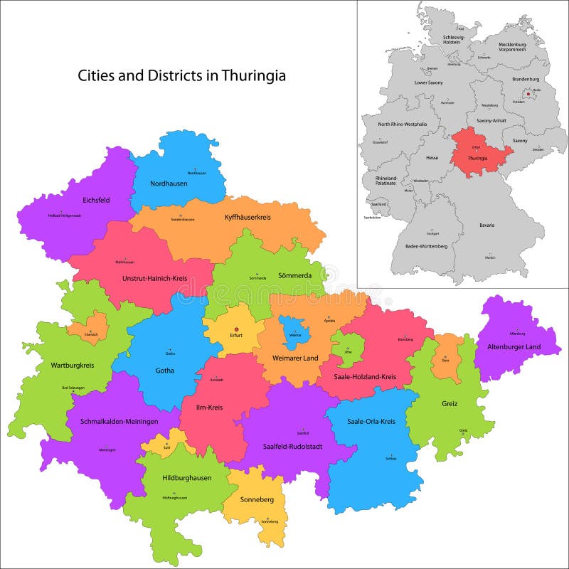
Free with trial State of Germany - Thuringia. Administrative division of Germany. Map of Thuringia with cities and districts. Maple map vectors State of Germany - Thuringia. Administrative division of Germany. Map of Thuringia with cities and districts
Free with trial Rwanda map. Administrative division of the Republic of Rwanda. Maple map vectors Rwanda map. Administrative division of the Republic of Rwanda
Free with trial Liberia map. Administrative division of the Republic of Liberia. Maple map vectors Liberia map. Administrative division of the Republic of Liberia
Free with trial Botswana map. Administrative division of the Republic of Botswana. Maple map vectors Botswana map. Administrative division of the Republic of Botswana
Free with trial Swaziland map. Administrative division of the Kingdom of Swaziland. Maple map vectors Swaziland map. Administrative division of the Kingdom of Swaziland
Free with trial Bangladesh map. Administrative division of the Peoples Republic of Bangladesh. Maple map vectors Bangladesh map. Administrative division of the Peoples Republic of Bangladesh
Free with trial Mauritania map. Administrative division of the Republic of the Islamic Republic of Mauritania. Maple map vectors Mauritania map. Administrative division of the Republic of the Islamic Republic of Mauritania
Free with trial Map of New Brunswick. New Brunswick is one of Canada three Maritime provinces and is the only constitutionally bilingual province. Maple map vectors Map of New Brunswick. New Brunswick is one of Canada three Maritime provinces and is the only constitutionally bilingual province
Free with trial Gabon map. Administrative division of the Gabonese Republic. Maple map vectors Gabon map. Administrative division of the Gabonese Republic
Free with trial Niger map. Administrative division of the Republic of Niger. Maple map vectors Niger map. Administrative division of the Republic of Niger
Free with trial Nepal map. Administrative division of the Democratic Republic of Nepal. Maple map vectors Nepal map. Administrative division of the Democratic Republic of Nepal
Free with trial Bhutan map. Administrative division of the Kingdom of Bhutan. Maple map vectors Bhutan map. Administrative division of the Kingdom of Bhutan
Free with trial Guinea map. Administrative division of the Republic of Guinea. Maple map vectors Guinea map. Administrative division of the Republic of Guinea
Free with trial Brunei map. Administrative division of the Nation of Brunei. Maple map vectors Brunei map. Administrative division of the Nation of Brunei
Free with trial Lesotho map. Administrative division of the Kingdom of Lesotho. Maple map vectors Lesotho map. Administrative division of the Kingdom of Lesotho
Free with trial Burundi map. Administrative division of the Republic of Burundi. Maple map vectors Burundi map. Administrative division of the Republic of Burundi
Free with trial Eritrea map. Administrative division of the State of Eritrea. Maple map vectors Eritrea map. Administrative division of the State of Eritrea
Free with trial Senegal map. Administrative division of the Republic of Senegal. Maple map vectors Senegal map. Administrative division of the Republic of Senegal
Free with trial Map of Yukon. Yukon is the westernmost and smallest of Canada three federal territories. Maple map vectors Map of Yukon. Yukon is the westernmost and smallest of Canada three federal territories
Free with trial Djibouti map. Administrative division of the Republic of Djibouti. Maple map vectors Djibouti map. Administrative division of the Republic of Djibouti
Free with trial Bora bora map. Bora Bora is an island in the Leeward group of the Society Islands of French Polynesia, an overseas collectivity of France in the Pacific Ocean. Maple map vectors Bora bora map. Bora Bora is an island in the Leeward group of the Society Islands of French Polynesia, an overseas collectivity of France in the Pacific Ocean
Free with trial Map of Alberta. Alberta is Canada fourth-most populous province and the most populous of Canada three prairie provinces. Maple map vectors Map of Alberta. Alberta is Canada fourth-most populous province and the most populous of Canada three prairie provinces
Free with trial Tajikistan map. Administrative division of the Republic of Tajikistan. Maple map vectors Tajikistan map. Administrative division of the Republic of Tajikistan
Free with trial Administrative division of Turkmenistan, is one of the Turkic states in Central Asia. Maple map vectors Turkmenistan map. Administrative division of Turkmenistan, is one of the Turkic states in Central Asia. Administrative division of Turkmenistan, is one of the Turkic states in Central Asia.
Free with trial Map of Newfoundland and Labrador. Newfoundland and Labrador is the most easterly province of Canada. Maple map vectors Map of Newfoundland and Labrador. Newfoundland and Labrador is the most easterly province of Canada
Free with trial Equatorial Guinea map. Administrative division of the Republic of Equatorial Guinea. Maple map vectors Equatorial Guinea map. Administrative division of the Republic of Equatorial Guinea
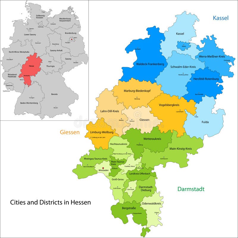
Free with trial State of Germany - Hesse. Administrative division of Germany. Map of Hesse with cities and districts. Maple map vectors State of Germany - Hesse. Administrative division of Germany. Map of Hesse with cities and districts
Free with trial State of Germany - Saarland. Administrative division of Germany. Map of Saarland with cities and districts. Maple map vectors State of Germany - Saarland. Administrative division of Germany. Map of Saarland with cities and districts
Free with trial Map of Prince Edward Island. Prince Edward Island is a province of Canada consisting of the island of the same name, as well as several much smaller islands. Maple map vectors Map of Prince Edward Island. Prince Edward Island is a province of Canada consisting of the island of the same name, as well as several much smaller islands
Free with trial Map of Northwest Territories. The Northwest Territories is a territory of Canada. Maple map vectors Map of Northwest Territories. The Northwest Territories is a territory of Canada
Free with trial Central African Republic map. Administrative division of the Central African Republic. Maple map vectors Central African Republic map. Administrative division of the Central African Republic
Free with trial Map of Quebec. Quebec is the second-most populous province of Canada and the only one to have a predominantly French-speaking population. Maple map vectors Map of Quebec. Quebec is the second-most populous province of Canada and the only one to have a predominantly French-speaking population
Free with trial State of Germany - Mecklenburg-Vorpommern. Administrative division of Germany. Map of Mecklenburg-Vorpommern with cities and districts. Maple map vectors State of Germany - Mecklenburg-Vorpommern. Administrative division of Germany. Map of Mecklenburg-Vorpommern with cities and districts
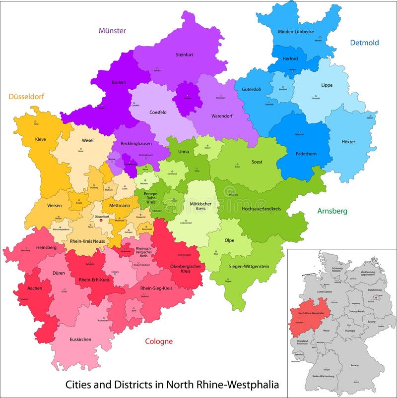
Free with trial State of Germany - North Rhine-Westphalia. Administrative division of Germany. Map of North Rhine-Westphalia with cities and districts. Maple map vectors State of Germany - North Rhine-Westphalia. Administrative division of Germany. Map of North Rhine-Westphalia with cities and districts
Free with trial Comoros map. Administrative division of the Union of the Comoros. Maple map vectors Comoros map. Administrative division of the Union of the Comoros
Free with trial Cape Verde map. Administrative division of the Republic of Cape Verde. Maple map vectors Cape Verde map. Administrative division of the Republic of Cape Verde
Free with trial Map of Manitoba. Manitoba is a province at the longitudinal centre of Canada. Maple map vectors Map of Manitoba. Manitoba is a province at the longitudinal centre of Canada
Free with trial Guinea-Bissau map. Administrative division of the Republic of Guinea-Bissau. Maple map vectors Guinea-Bissau map. Administrative division of the Republic of Guinea-Bissau
Free with trial Canary Islands map. Administrative division of the Canary Islands. Maple map vectors Canary Islands map. Administrative division of the Canary Islands
Free with trial Rwanda map. Administrative division of the Republic of Rwanda. Maple map vectors Rwanda map. Administrative division of the Republic of Rwanda
Free with trial Fiji map. Fiji is an island country in Melanesia in the South Pacific Ocean. Maple map vectors Fiji map. Fiji is an island country in Melanesia in the South Pacific Ocean
Free with trial Montserrat map. Montserrat is an island which is a British Overseas Territory in the Caribbean. Maple map vectors Montserrat map. Montserrat is an island which is a British Overseas Territory in the Caribbean
Free with trial Gibraltar map. Gibraltar is a British Overseas Territory located on the southern end of the Iberian Peninsula at the entrance of the Mediterranean. Maple map vectors Gibraltar map. Gibraltar is a British Overseas Territory located on the southern end of the Iberian Peninsula at the entrance of the Mediterranean
Free with trial State of Germany - Saxony-Anhalt. Administrative division of Germany. Map of Saxony-Anhalt with cities and districts. Maple map vectors State of Germany - Saxony-Anhalt. Administrative division of Germany. Map of Saxony-Anhalt with cities and districts
Free with trial Madagascar map. Administrative division of the Republic of Madagascar. Maple map vectors Madagascar map. Administrative division of the Republic of Madagascar
Free with trial Kenya map. Administrative division of the Republic of Kenya. Maple map vectors Kenya map. Administrative division of the Republic of Kenya
Free with trial Burundi map. Administrative division of the Republic of Burundi. Maple map vectors Burundi map. Administrative division of the Republic of Burundi
Free with trial Ceuta and Melilla map. Illustration of a autonomous city of Ceuta and Melilla. Maple map vectors Ceuta and Melilla map. Illustration of a autonomous city of Ceuta and Melilla
Free with trial Map of Bermuda. Bermuda is a British Overseas Territory in the North Atlantic Ocean. Maple map vectors Map of Bermuda. Bermuda is a British Overseas Territory in the North Atlantic Ocean
Free with trial Map of Greece. Greece, historically also known as Hellas, is a country in Southern Europe. Maple map vectors Map of Greece. Greece, historically also known as Hellas, is a country in Southern Europe
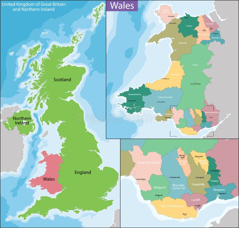
Free with trial Wales is a country that is part of the United Kingdom. Maple map vectors Map of Wales. Wales is a country that is part of the United Kingdom. Wales is a country that is part of the United Kingdom.
Free with trial Akrotiri and Dhekelia map. Sovereign Base Areas of Akrotiri and Dhekelia, is a British Overseas Territory on the island of Cyprus. Maple map vectors Akrotiri and Dhekelia map. Sovereign Base Areas of Akrotiri and Dhekelia, is a British Overseas Territory on the island of Cyprus
Free with trial Map of Saskatchewan. Saskatchewan is a prairie and boreal province in west-central Canada, the only province without natural borders. Maple map vectors Map of Saskatchewan. Saskatchewan is a prairie and boreal province in west-central Canada, the only province without natural borders
Free with trial British Columbia is the westernmost province of Canada, with a population of more than 4 million people located between the Pacific Ocean and the Rocky Mountains. Maple map vectors Map of British Columbia. British Columbia is the westernmost province of Canada, with a population of more than 4 million people located between the Pacific. British Columbia is the westernmost province of Canada, with a population of more than 4 million people located between the Pacific Ocean and the Rocky Mountains.
Free with trial New Zealand is an island country in the southwestern Pacific Ocean. Maple map vectors New Zealand map. New Zealand is an island country in the southwestern Pacific Ocean. New Zealand is an island country in the southwestern Pacific Ocean.
Free with trial Spain is a sovereign state located on the Iberian Peninsula in southwestern Europe, with two large archipelagos the Balearic Islands in the Mediterranean Sea. Maple map vectors Map of Spain. Spain is a sovereign state located on the Iberian Peninsula in southwestern Europe, with two large archipelagos the Balearic Islands in the. Spain is a sovereign state located on the Iberian Peninsula in southwestern Europe, with two large archipelagos the Balearic Islands in the Mediterranean Sea
Free with trial The Aegean Sea is an elongated embayment of the Mediterranean Sea located between the Greek and Anatolian peninsulas, i. e. , between the mainlands of Greece and Turkey. Maple map vectors Aegean Sea map. The Aegean Sea is an elongated embayment of the Mediterranean Sea located between the Greek and Anatolian peninsulas, i.e., between the mainlands. The Aegean Sea is an elongated embayment of the Mediterranean Sea located between the Greek and Anatolian peninsulas, i.e., between the mainlands of Greece and Turkey.
Free with trial Map of Martinique. Martinique is an insular region of France located in the Lesser Antilles in the eastern Caribbean Sea. Maple map vectors Map of Martinique. Martinique is an insular region of France located in the Lesser Antilles in the eastern Caribbean Sea
Free with trial Map of Portugal. The Portuguese Republic is a country on the Iberian Peninsula in Southwestern Europe. Maple map vectors Map of Portugal. The Portuguese Republic is a country on the Iberian Peninsula in Southwestern Europe
Free with trial Comoros map. Administrative division of the Union of the Comoros. Maple map vectors Comoros map. Administrative division of the Union of the Comoros
Free with trial Mauritius map. Administrative division of the Republic of Mauritius. Maple map vectors Mauritius map. Administrative division of the Republic of Mauritius
 Sign in