Free with trial Cartographer making a map. Cartographers making a map based on topography. Mapmaking vectors Cartographer making a map. Cartographers making a map based on topography
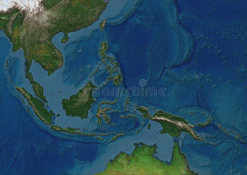
Free with trial A physical map of the greater region of South East Asia (plus partially Northern Australia) without borders or country names. It's product of 10+ years mapmaking practice made in Germany. The details and colors are superb and it looks pseudo three dimensional. The format of the map according to ISO 216 standard is A series, means it's usable as DIN A4, A3, A2 format and so on. Mapmaking vectors South East Asia - physical map. A physical map of the greater region of South East Asia (plus partially Northern Australia) without borders or country names. It'. A physical map of the greater region of South East Asia (plus partially Northern Australia) without borders or country names. It's product of 10+ years mapmaking practice made in Germany. The details and colors are superb and it looks pseudo three dimensional. The format of the map according to ISO 216 standard is A series, means it's usable as DIN A4, A3, A2 format and so on.
Free with trial This blank political map features the outline of North America, showing the continents without labels or colors. It is ideal for educational purposes, planning, and geographic analysis. Mapmaking vectors Blank political vector map of North America. This blank political map features the outline of North America, showing the continents without labels or colors. It. This blank political map features the outline of North America, showing the continents without labels or colors. It is ideal for educational purposes, planning, and geographic analysis.
Free with trial Travel poster, urban street plan city map Buenos aires and Montevideo, vector illustration. For decorating walls. Mapmaking vectors Travel poster, urban street plan city map Buenos aires and Montevideo, vector illustration. For decorating walls
Free with trial Travel poster, urban street plan city map Rio de Janeiro and Sao Paulo, vector illustration. For decorating walls. Mapmaking vectors Travel poster, urban street plan city map Rio de Janeiro and Sao Paulo, vector illustration. For decorating walls
Free with trial This illustration features a collection of vintage navigation and drawing instruments, presented in a clean, black and white, etched style. The image showcases three distinct compasses, each with cardinal directions marked, and three drawing dividers (compasses) with pointed legs. The arrangement suggests a theme of exploration, measurement, and historical tools, ideal for educational, artistic, or design-related projects. Mapmaking vectors Vintage Navigation Tools: Compasses and Drawing Dividers. This illustration features a collection of vintage navigation and drawing instruments, presented in a. This illustration features a collection of vintage navigation and drawing instruments, presented in a clean, black and white, etched style. The image showcases three distinct compasses, each with cardinal directions marked, and three drawing dividers (compasses) with pointed legs. The arrangement suggests a theme of exploration, measurement, and historical tools, ideal for educational, artistic, or design-related projects.
Free with trial Point Zero symbol, Notre Dame, Paris, vector file, illustration. Mapmaking vectors Point Zero symbol, Notre Dame, Paris. Vector file, illustration
Free with trial Surveyor concept. Land surveying technology, geodesy science. Construction business, mapmaking and real estate project. People with compass, map and topographic equipment. Flat vector illustration. Mapmaking vectors Surveyor concept. Land surveying technology, geodesy science. Construction business, mapmaking and real estate project. People with compass, map and
Free with trial 3D Map of London with Waterways Highlighted. Isometric 3D map of London showing rivers and lakes in blue with a gray background. Mapmaking vectors 3D Map of London with Waterways Highlighted. Isometric 3D map of London showing rivers and lakes in blue with a gray background
Free with trial Surveyor web banner or landing page set. Land surveying technology, geodesy science. Construction business, mapmaking and real estate project. Topographic equipment. Flat vector illustration. Mapmaking vectors Surveyor web banner or landing page set. Land surveying technology. Geodesy science. Construction business, mapmaking and real estate project. Topographic. Surveyor web banner or landing page set. Land surveying technology, geodesy science. Construction business, mapmaking and real estate project. Topographic equipment. Flat vector illustration
Free with trial Surveyor typographic header. Land surveying technology, geodesy science. Construction business, mapmaking and real estate project. Topographic equipment. Flat vector illustration. Mapmaking vectors Surveyor typographic header. Land surveying technology, geodesy science. Construction business, mapmaking and real estate project. Topographic equipment. Flat
Free with trial The world map in vintage style, showcasing North America and South America with a retro-style map design. Mapmaking vectors Vintage Style North America World Map for Cartography and Travel Illustration. The world map in vintage style, showcasing North America and South America with a. The world map in vintage style, showcasing North America and South America with a retro-style map design.
Free with trial Circumferentor or Surveyor`s Compass, vintage engraved illustration. Dictionary of Words and Things - Larive and Fleury - 1895. Mapmaking vectors Circumferentor or Surveyor`s Compass, vintage engraving. Circumferentor or Surveyor`s Compass, vintage engraved illustration. Dictionary of Words and Things. Circumferentor or Surveyor`s Compass, vintage engraved illustration. Dictionary of Words and Things - Larive and Fleury - 1895
Free with trial Surveying expert typographic header. Land surveying technology, geodesy science. Construction business, mapmaking and real estate project. Topographic equipment. Flat vector illustration. Mapmaking vectors Surveying expert typographic header. Land surveying technology. Geodesy science. Construction business, mapmaking and real estate project. Topographic. Surveying expert typographic header. Land surveying technology, geodesy science. Construction business, mapmaking and real estate project. Topographic equipment. Flat vector illustration
Free with trial Silhouette of Puerto Rico map filled with the Puerto Rican flag design, symbolizing national pride, cultural heritage, and geographic identity. Mapmaking vectors Puerto Rico Map Silhouette with National Flag Design. Silhouette of Puerto Rico map filled with the Puerto Rican flag design, symbolizing national pride. Silhouette of Puerto Rico map filled with the Puerto Rican flag design, symbolizing national pride, cultural heritage, and geographic identity
Free with trial Cartography and Mapmaking Doodle SVG. Black and White Cartography and Mapmaking Doodle Collection with 18 Navigation Tools and Exploration Objects. Mapmaking vectors Cartography and Mapmaking Doodle SVG. Black and White Cartography and Mapmaking Doodle Collection with 18 Navigation Tools and Exploration Objects
Free with trial A charming illustration of a vintage mapmaker's desk, adorned with old maps, a compass, and an inkwell. This image evokes cartography, historical exploration, and the intricate art of mapmaking. Perfect for historical content, adventure themes, or sophisticated branding, vector design Generative AI. Mapmaking vectors Vintage Mapmaker\'s Desk, Cartography Tools, Old World Charm, vector design Generative AI. A charming illustration of a vintage mapmaker's desk, adorned with old. A charming illustration of a vintage mapmaker's desk, adorned with old maps, a compass, and an inkwell. This image evokes cartography, historical exploration, and the intricate art of mapmaking. Perfect for historical content, adventure themes, or sophisticated branding, vector design Generative AI
Free with trial An illustration featuring a display rack filled with antique maps and charts, perfect for historical cartography and exploration themes. This image is ideal for museums, travel agencies, or any content celebrating the art of mapmaking and the spirit of discovery. Rich in historical detail, vector design Generative AI. Mapmaking vectors Antique Map Display, Historical Cartography, Exploration Theme, vector design Generative AI. An illustration featuring a display rack filled with antique maps. An illustration featuring a display rack filled with antique maps and charts, perfect for historical cartography and exploration themes. This image is ideal for museums, travel agencies, or any content celebrating the art of mapmaking and the spirit of discovery. Rich in historical detail, vector design Generative AI
Free with trial A detailed map, featuring an elaborate compass rose, symbolizing navigation, geographical insights, and exploration. This illustration is perfect for travel agencies, cartography, historical documents, or designs inspiring discovery and charting new paths. It captures precision and the art of mapmaking, vector design Generative AI. Mapmaking vectors Detailed Map with Compass Rose, Navigation Geographical Insights, vector design Generative AI. A detailed map, featuring an elaborate compass rose, symbolizing. A detailed map, featuring an elaborate compass rose, symbolizing navigation, geographical insights, and exploration. This illustration is perfect for travel agencies, cartography, historical documents, or designs inspiring discovery and charting new paths. It captures precision and the art of mapmaking, vector design Generative AI
Free with trial A classic vector illustration of a world map in a vintage style, symbolizing antique cartography and exploration. This icon is ideal for themes of historical travel, adventure, discovery, and old-world geography. It evokes a sense of timeless exploration and the beauty of traditional mapmaking, vector design Generative AI. Mapmaking vectors World Map Vintage Style Antique Cartography Design, vector design Generative AI. A classic vector illustration of a world map in a vintage style, symbolizing. A classic vector illustration of a world map in a vintage style, symbolizing antique cartography and exploration. This icon is ideal for themes of historical travel, adventure, discovery, and old-world geography. It evokes a sense of timeless exploration and the beauty of traditional mapmaking, vector design Generative AI
Free with trial A detailed illustration featuring two vintage world globes, showcasing historical cartographic elements and old-world charm. These timeless educational tools are perfect for academic projects, travel themes, or any design celebrating global history and the art of traditional mapmaking, vector design Generative AI. Mapmaking vectors Vintage World Globes for Historical Geography, vector design Generative AI. A detailed illustration featuring two vintage world globes, showcasing historical. A detailed illustration featuring two vintage world globes, showcasing historical cartographic elements and old-world charm. These timeless educational tools are perfect for academic projects, travel themes, or any design celebrating global history and the art of traditional mapmaking, vector design Generative AI
Free with trial Stylized island map design with geographical features, showcasing cartography and the art of mapmaking, representing exploration, navigation, and the beauty of geographical contours and island shapes vector design Generative AI. Mapmaking vectors Island map design, geographical cartography vector design Generative AI. Stylized island map design with geographical features, showcasing cartography and the. Stylized island map design with geographical features, showcasing cartography and the art of mapmaking, representing exploration, navigation, and the beauty of geographical contours and island shapes vector design Generative AI
Free with trial A nostalgic vector illustration of vintage writing tools, including a compass, a quill pen, and a blank scroll, on a desk. This flat design is perfect for themes of adventure, mapmaking, or historical exploration. It conveys a sense of discovery and classic craftsmanship, making it ideal for travel logs or academic content, vector design Generative AI. Mapmaking vectors Vintage Compass and Writing Tools, vector design Generative AI. A nostalgic vector illustration of vintage writing tools, including a compass, a quill pen, and a. A nostalgic vector illustration of vintage writing tools, including a compass, a quill pen, and a blank scroll, on a desk. This flat design is perfect for themes of adventure, mapmaking, or historical exploration. It conveys a sense of discovery and classic craftsmanship, making it ideal for travel logs or academic content, vector design Generative AI
Free with trial Classic vintage map illustration with a quill pen, representing historical exploration and cartography. Ideal for history blogs, adventure stories, and projects needing a touch of vintage exploration and mapmaking. vector design Generative AI. Mapmaking vectors Vintage map with quill pen, historical exploration and cartography illustration vector design Generative AI. Classic vintage map illustration with a quill pen. Classic vintage map illustration with a quill pen, representing historical exploration and cartography. Ideal for history blogs, adventure stories, and projects needing a touch of vintage exploration and mapmaking. vector design Generative AI
Free with trial An antique,style world map with intricate details, symbolizing vintage cartography, global exploration, and the history of mapmaking for educational and historical themes vector design Generative AI. Mapmaking vectors Vintage world map, antique cartography and global exploration vector design Generative AI. An antique,style world map with intricate details, symbolizing vintage. An antique,style world map with intricate details, symbolizing vintage cartography, global exploration, and the history of mapmaking for educational and historical themes vector design Generative AI
Free with trial An ancient map of Europe, representing historical cartography art, old world geography, and the history of mapmaking and European landscapes. vector design Generative AI. Mapmaking vectors Ancient map of Europe, historical cartography art. vector design Generative AI. An ancient map of Europe, representing historical cartography art, old world. An ancient map of Europe, representing historical cartography art, old world geography, and the history of mapmaking and European landscapes. vector design Generative AI
Free with trial An illustrated old world map with intricate details, showcasing vintage cartography design, historical geography, and the artistry of mapmaking. vector design Generative AI. Mapmaking vectors Old world map illustration, vintage cartography design. vector design Generative AI. An illustrated old world map with intricate details, showcasing vintage. An illustrated old world map with intricate details, showcasing vintage cartography design, historical geography, and the artistry of mapmaking. vector design Generative AI
Free with trial Detailed outline map of the USA. The silhouette of the United States, including Alaska and Hawaii. The map serves as a clear outline of the country geography. Mapmaking vectors Detailed outline map of the USA. The silhouette of the United States, including Alaska and Hawaii. The map serves as a clear outline of the country geography
Free with trial Blue map pointer with a circular void in the center sits on a plain background. The pointer displays a simple design with a shadow effect, indicating a location. Mapmaking vectors Map Pointer With Dropped Shadow. Blue map pointer with a circular void in the center sits on a plain background. The pointer displays a simple design with a. Blue map pointer with a circular void in the center sits on a plain background. The pointer displays a simple design with a shadow effect, indicating a location.
Free with trial Blue map pointer with a circular void in the center sits on a plain background. The pointer displays a simple design with a shadow effect, indicating a location. Mapmaking vectors Map Pointer With Dropped Shadow. Blue map pointer with a circular void in the center sits on a plain background. The pointer displays a simple design with a. Blue map pointer with a circular void in the center sits on a plain background. The pointer displays a simple design with a shadow effect, indicating a location.
Free with trial Map of the Great Lakes in North America with Labels for Superior, Michigan, Huron, Erie, Ontario. Mapmaking vectors Map of the Great Lakes in North America with Labels for Superior, Michigan, Huron, Erie, Ontario.
Free with trial World map with pin on Europe. A world map with a pin on Europe. Mapmaking vectors World map with pin on Europe. A world map with a pin on Europe
Free with trial Minimal Earth globe vector icon in clean line art style, symbolizing ecology, sustainability, and environmental awareness. Ideal eco friendly branding, Earth Day graphics, designs vector illustration. Mapmaking vectors Minimal Earth globe vector icon in clean line art style, symbolizing ecology, sustainability, environmental awareness. Minimal Earth globe vector icon in clean. Minimal Earth globe vector icon in clean line art style, symbolizing ecology, sustainability, and environmental awareness. Ideal eco friendly branding, Earth Day graphics, designs vector illustration
Free with trial A pair of location pin icons, one in black and one in white, showcasing simple flat design style. Ideal for digital mapping or navigation themes. Mapmaking vectors Black and White Location Pin Icons in Simple Flat Design Style. A pair of location pin icons, one in black and one in white, showcasing simple flat design style. A pair of location pin icons, one in black and one in white, showcasing simple flat design style. Ideal for digital mapping or navigation themes
Free with trial Globe and cheese slice highlighting international cuisine and cultural exploration. Ideal for travel, food, education, environment, culture, agriculture, simple landing page. Mapmaking vectors Globe and Cheese Slice Representing Global Food and Cultural Connections. Globe and cheese slice highlighting international cuisine and cultural exploration. Globe and cheese slice highlighting international cuisine and cultural exploration. Ideal for travel, food, education, environment, culture, agriculture, simple landing page
Free with trial Minimal line art illustration of Cyprus map. Mapmaking vectors Cyprus Map Minimal Line Art. Minimal line art illustration of Cyprus map. minimal line art illustration of Cyprus map.
Free with trial Estonia Map Minimal Line Art. Minimal line art illustration of Estonia map. Mapmaking vectors Estonia Map Minimal Line Art. Minimal line art illustration of Estonia map. Estonia Map Minimal Line Art
Free with trial Detailed Silhouettes of Ukrainian Regions Showcasing Political Boundaries in a Simple Black Line Vector Style for Easy Reference. And Geographic Understanding. Mapmaking vectors Detailed Silhouettes of Ukrainian Regions Showcasing Political Boundaries in a Simple Black Line Vector Style for Easy Reference. And Geographic Understanding
Free with trial Map of Rajasthan state in India. Detailed map of Rajasthan state India. Mapmaking vectors Map of Rajasthan state in India. Detailed map of Rajasthan state India
Free with trial A collection of vintage brass navigation tools including a compass, sundial, telescope, and divider is displayed against a pure white background. This detailed high-quality still life image of surveying instruments and nautical gear was Rendered by Ai. Mapmaking vectors Antique Navigation Tools Collection on White. A collection of vintage brass navigation tools including a compass, sundial, telescope, and divider is displayed. A collection of vintage brass navigation tools including a compass, sundial, telescope, and divider is displayed against a pure white background. This detailed high-quality still life image of surveying instruments and nautical gear was Rendered by Ai
Free with trial Compass tattoo icon with premium line art, minimalist circular shape and needle,. Symbol for navigation, directions and mapping. Mapmaking vectors Compass tattoo icon with premium line art, minimalist circular shape and needle,. Symbol for navigation, directions and mapping
Free with trial A flat black-and-white vector icon of a folded paper map featuring a location pin, city skyline, and route path. Mapmaking vectors Folded Paper Map Icon with Location Marker and Travel Destination Symbols. A flat black-and-white vector icon of a folded paper map featuring a location pin. A flat black-and-white vector icon of a folded paper map featuring a location pin, city skyline, and route path
Free with trial United Kingdom map silhouette in black. A sleek black silhouette map of the United Kingdom, perfect for design and commercial use. Mapmaking vectors United Kingdom map silhouette in black. A sleek black silhouette map of the United Kingdom, perfect for design and commercial use
Free with trial Minimal line art illustration of Denmark map. Mapmaking vectors Denmark Map Minimal Line Art. Minimal line art illustration of Denmark map. minimal line art illustration of Denmark map.
Free with trial Black-and-white vector illustration of an architect working on a detailed city master plan blueprint. Mapmaking vectors Architect Working on City Planning and Urban Development Blueprint Illustration. Black-and-white vector illustration of an architect working on a detailed city. black-and-white vector illustration of an architect working on a detailed city master plan blueprint
Free with trial Amazonas state map vector illustration using various decorative pattern styles. Abstract graphic designs suitable for professional mapping and creative layouts. Mapmaking vectors Six stylized maps of Amazonas region featuring unique geometric and pattern textures. Amazonas state map vector illustration using various decorative pattern. Amazonas state map vector illustration using various decorative pattern styles. Abstract graphic designs suitable for professional mapping and creative layouts
Free with trial This image is created by Artificial Intelligence. A detailed black and white illustration of a compass on a folded topographic map with labeled geographical features. The map showcases various terrains, roads, and paths. The image exudes a sense of adventure and exploration. The monochromatic color scheme and classic illustration style evoke a nostalgic feel. The image could be used for. Mapmaking vectors Vintage black and white illustration of a compass on a topographic map. This image is created by Artificial Intelligence. A detailed black and white illustration. This image is created by Artificial Intelligence. A detailed black and white illustration of a compass on a folded topographic map with labeled geographical features. The map showcases various terrains, roads, and paths. The image exudes a sense of adventure and exploration. The monochromatic color scheme and classic illustration style evoke a nostalgic feel. The image could be used for
Free with trial This image depicts a blank outline map of the United States of America, showcasing the boundaries of all 50 states. The map includes Alaska and Hawaii, positioned in the bottom left and bottom right corners respectively. The map is devoid of any labels or additional markings, providing a clear and uncluttered view of the geographical layout of the country. Mapmaking vectors Blank outline map of the united states of america. This image depicts a blank outline map of the United States of America, showcasing the boundaries of all 50. This image depicts a blank outline map of the United States of America, showcasing the boundaries of all 50 states. The map includes Alaska and Hawaii, positioned in the bottom left and bottom right corners respectively. The map is devoid of any labels or additional markings, providing a clear and uncluttered view of the geographical layout of the country
Free with trial A detailed and monochromatic representation of the Earth's surface, showcasing the continents and oceans in a spherical format. Mapmaking vectors Global perspective of earth\'s surface. A detailed and monochromatic representation of the Earth's surface, showcasing the continents and oceans in a spherical. A detailed and monochromatic representation of the Earth's surface, showcasing the continents and oceans in a spherical format
Free with trial Latvia map design set featuring solid shapes and detailed outline paths. Professional vector graphics for school geography projects travel planning web mapping and infographic uses. Mapmaking vectors Latvia country map vector illustration design elements. Latvia map design set featuring solid shapes and detailed outline paths. Professional vector graphics for. Latvia map design set featuring solid shapes and detailed outline paths. Professional vector graphics for school geography projects travel planning web mapping and infographic uses
Free with trial Set of Russia map design elements including solid fill and outline styles. Isolated country geography vector graphics for travel planning education projects and territorial studies. Mapmaking vectors Russia country map vector illustration design elements. Set of Russia map design elements including solid fill and outline styles. Isolated country geography. Set of Russia map design elements including solid fill and outline styles. Isolated country geography vector graphics for travel planning education projects and territorial studies
Free with trial Collection of Lebanon map designs showing flat colors and outlined paths. Ideal vector graphic resources for educational presentations cartography travel planning and regional studies. Mapmaking vectors Lebanon country map vector illustration design elements. Collection of Lebanon map designs showing flat colors and outlined paths. Ideal vector graphic resources. Collection of Lebanon map designs showing flat colors and outlined paths. Ideal vector graphic resources for educational presentations cartography travel planning and regional studies
Free with trial Liberia map design elements featuring solid silhouettes and clean line art. High quality vector graphics for geography lessons travel brochures project mapping and visual design. Mapmaking vectors Liberia country map vector illustration design elements. Liberia map design elements featuring solid silhouettes and clean line art. High quality vector graphics. Liberia map design elements featuring solid silhouettes and clean line art. High quality vector graphics for geography lessons travel brochures project mapping and visual design
Free with trial Lesotho map vector collection containing solid forms and outline style graphics. Essential design assets for cartography web mapping academic projects and geographical studies. Mapmaking vectors Lesotho country map vector illustration design elements. Lesotho map vector collection containing solid forms and outline style graphics. Essential design assets. Lesotho map vector collection containing solid forms and outline style graphics. Essential design assets for cartography web mapping academic projects and geographical studies
Free with trial This image features a detailed black and white silhouette of a globe. The globe showcases the continents of North and South America, Europe, Africa, and parts of Asia. The image is rendered in a stark contrast of black and white, emphasizing the outlines and shapes of the landmasses. The globe is depicted from a perspective that highlights the curvature of the Earth and the distinct boundaries of. Mapmaking vectors Black and white globe silhouette. This image features a detailed black and white silhouette of a globe. The globe showcases the continents of North and South. This image features a detailed black and white silhouette of a globe. The globe showcases the continents of North and South America, Europe, Africa, and parts of Asia. The image is rendered in a stark contrast of black and white, emphasizing the outlines and shapes of the landmasses. The globe is depicted from a perspective that highlights the curvature of the Earth and the distinct boundaries of
Free with trial The image shows a stylized map with three blue location markers connected by a route line. The markers are placed on a terrain map with elevation changes, suggesting a geographical or navigational context. The design is clean and minimalistic, focusing on the functionality of location tracking and route planning. Mapmaking vectors Gps map markers indicating locations on a terrain landscape. The image shows a stylized map with three blue location markers connected by a route line. The. The image shows a stylized map with three blue location markers connected by a route line. The markers are placed on a terrain map with elevation changes, suggesting a geographical or navigational context. The design is clean and minimalistic, focusing on the functionality of location tracking and route planning
Free with trial A comprehensive array of medieval architectural elements and warfare machinery rendered in a charming, hand-drawn blue marker style for creative projects. Mapmaking vectors Hand-Drawn Medieval Castle Siege Doodles. A comprehensive array of medieval architectural elements and warfare machinery rendered in a charming, hand-drawn blue. A comprehensive array of medieval architectural elements and warfare machinery rendered in a charming, hand-drawn blue marker style for creative projects.
Free with trial Black and white graphic map outline of Greenland, showcasing its shape with defined regional divisions. The map includes straight lines demarcating different areas. The coastal contours are depicted with jagged lines, highlighting the island's irregular coastline. The text "GREENLAND" is prominently displayed at the top. The map provides a simplified view focusing on the geographical outline and basic territorial segmentation. Mapmaking vectors Simple black and white graphic map outline illustration of Greenland divided into regions. Black and white graphic map outline of Greenland, showcasing its shape. Black and white graphic map outline of Greenland, showcasing its shape with defined regional divisions. The map includes straight lines demarcating different areas. The coastal contours are depicted with jagged lines, highlighting the island's irregular coastline. The text "GREENLAND" is prominently displayed at the top. The map provides a simplified view focusing on the geographical outline and basic territorial segmentation.
Free with trial A golden compass with a white face and black and red details, set against a transparent background. The compass features a circular dial with a rotating bezel and a magnetic needle pointing towards the north. The image is isolated, making it suitable for use as an icon or graphic element in various designs and applications. Mapmaking vectors A golden compass on a transparent background for navigation purposes. A golden compass with a white face and black and red details, set against a transparent. A golden compass with a white face and black and red details, set against a transparent background. The compass features a circular dial with a rotating bezel and a magnetic needle pointing towards the north. The image is isolated, making it suitable for use as an icon or graphic element in various designs and applications.
Free with trial A bold dark blue silhouette map of Scotland showing counties and coastline on a pale beige backdrop. Ideal for geography, travel, education, and marketing visuals highlighting Scotland, maps, and regional identity. Mapmaking vectors Silhouette Map Of Scotland In Deep Blue For Geographic And Travel Design. A bold dark blue silhouette map of Scotland showing counties and coastline on a pale. A bold dark blue silhouette map of Scotland showing counties and coastline on a pale beige backdrop. Ideal for geography, travel, education, and marketing visuals highlighting Scotland, maps, and regional identity
 Sign in