Free with trial Silhouette of Istanbul at sunset. Vector silhouette of Istanbul cityscape against sunset sky. Marmara vectors Silhouette of Istanbul at sunset. Vector silhouette of Istanbul cityscape against sunset sky
Free with trial Drawing sketch illustration of Haydarpasa Dock and a ferry on the coast of the Bosphorus in Kadikoy, Istanbul. Marmara vectors Drawing sketch illustration of Haydarpasa, Kadikoy, Istanbul. Drawing sketch illustration of Haydarpasa Dock and a ferry on the coast of the Bosphorus in Kadikoy. Drawing sketch illustration of Haydarpasa Dock and a ferry on the coast of the Bosphorus in Kadikoy, Istanbul
Free with trial Highly detailed vector map of Greece with main cities,regions and roads. Marmara vectors Greece map. Highly detailed vector map of Greece with main cities,regions and roads. Highly detailed vector map of Greece with main cities,regions and roads.
Free with trial Highly detailed map of Turkey with main cities and roads. Marmara vectors Turkey map. Highly detailed map of Turkey with main cities and roads. Highly detailed map of Turkey with main cities and roads.
Free with trial City map Istanbul, travel vector poster design. Detailed plan of the city, rivers and streets. Marmara vectors City map Istanbul, travel vector poster design. Detailed plan of the city, rivers and streets
Free with trial Road map marmara sea with istanbul. Vector road map marmara sea with istanbul. Marmara vectors Road map marmara sea with istanbul. Vector road map marmara sea with istanbul
Free with trial Highly detailed physical map of Greece,in vector format,with all the relief forms,regions and big cities. Marmara vectors Physical map of Greece. Highly detailed physical map of Greece,in vector format,with all the relief forms,regions and big cities. Highly detailed physical map of Greece,in vector format,with all the relief forms,regions and big cities.
Free with trial Islamic mosque. Vector illustration of islamic mosque. Marmara vectors Islamic mosque. Vector illustration of islamic mosque
Free with trial Map of Ancient Byzantium. Illustration of map of Ancient Byzantium. Marmara vectors Map of Ancient Byzantium. Illustration of map of Ancient Byzantium
Free with trial Vector istanbul map with famous landmarks. Vector illustration colored istanbul map with famous landmarks. Marmara vectors Vector istanbul map with famous landmarks. Vector illustration colored istanbul map with famous landmarks
Free with trial Neon signboard of hookah. Neon sign hookah for lounge cafe emblem, arabian bar, shop. Vector Illustration. Marmara vectors Neon signboard of hookah. Neon sign hookah for lounge cafe emblem, arabian bar, shop. Vector Illustration
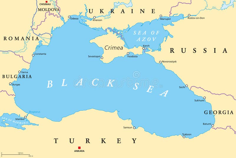
Free with trial Black Sea and Sea of Azov region political map with capitals, most important cities, borders and rivers. Body of water between Eastern Europe and Western Asia. Illustration. English labeling. Vector. Marmara vectors Black Sea and Sea of Azov region political map. With capitals, most important cities, borders and rivers. Body of water between Eastern Europe and Western Asia. Black Sea and Sea of Azov region political map with capitals, most important cities, borders and rivers. Body of water between Eastern Europe and Western Asia. Illustration. English labeling. Vector.
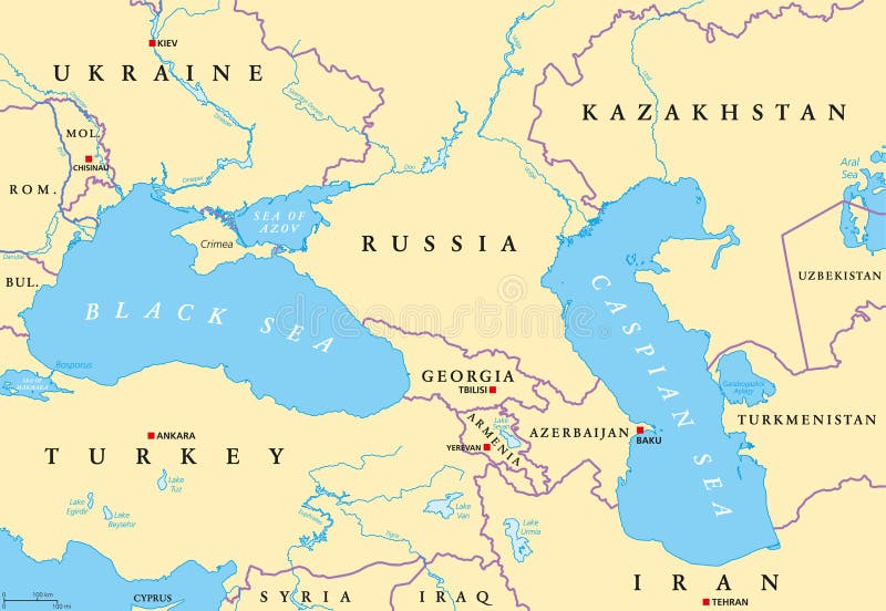
Free with trial Black Sea and Caspian Sea region political map with capitals, international borders, rivers and lakes. Bodies of water between Eastern Europe and Western Asia. Illustration. English labeling. Vector. Marmara vectors Black Sea and Caspian Sea region political map. With capitals, international borders, rivers and lakes. Bodies of water between Eastern Europe and Western Asia. Black Sea and Caspian Sea region political map with capitals, international borders, rivers and lakes. Bodies of water between Eastern Europe and Western Asia. Illustration. English labeling. Vector.
Free with trial Black sea map. Map of the black sea with the Neighboring states. Marmara vectors Black sea map. Map of the black sea with the Neighboring states
Free with trial Background, school of European garfish, fishes marine life. Banner fresh fish, simple water inhabitants. Seafood packaging and market. Vector illustration used in backdrop design. Marine life EPS10. Marmara vectors Background, school of European garfish, fishes marine life. Banner fresh fish, simple water inhabitants. Seafood packaging and. Market. Vector illustration used. Background, school of European garfish, fishes marine life. Banner fresh fish, simple water inhabitants. Seafood packaging and market. Vector illustration used in backdrop design. Marine life EPS10
Free with trial Istanbul logo. Good logo for istanbul, feel the istanbul from turkey. Illustrated on 03. 05. 2009. Marmara vectors Istanbul logo. Good logo for istanbul, feel the istanbul from turkey. Illustrated on 03.05.2009
Free with trial Large map of the turkish area of Marmara Bölgesi. Marmara vectors Large map of Marmara Bölgesi. Large map of the turkish area of Marmara Bölgesi. Large map of the turkish area of Marmara Bölgesi.
Free with trial Large map of the turkish area of Marmara Bölgesi. Marmara vectors Large map of Marmara Bölgesi. Large map of the turkish area of Marmara Bölgesi. Large map of the turkish area of Marmara Bölgesi.
Free with trial Large map of the turkish area of Marmara Bölgesi. Marmara vectors Large map of Marmara Bölgesi. Large map of the turkish area of Marmara Bölgesi. Large map of the turkish area of Marmara Bölgesi.
Free with trial Blue outline map of Sea of Marmara, Isolated vector siilhouette. Sea on white background. Marmara vectors Blue outline map of Sea of Marmara, Isolated vector siilhouette. Sea on white background
Free with trial Marmara map with Social Distancing stayathome tag. Illustration. Marmara vectors Marmara map with Social Distancing stayathome tag. Illustration
Free with trial Bosporus and Dardanelles, political map. The Turkish Straits, internationally significant and narrow waterways in Turkey. Passages, connecting the Aegean Sea and the Sea of Marmara with the Black Sea. Marmara vectors Bosporus and Dardanelles, the Turkish Straits, political map. Bosporus and Dardanelles, political map. The Turkish Straits, internationally significant and. Bosporus and Dardanelles, political map. The Turkish Straits, internationally significant and narrow waterways in Turkey. Passages, connecting the Aegean Sea and the Sea of Marmara with the Black Sea.
Free with trial The Bosporus or Bosphorus, political map. The Strait of Istanbul, a narrow, natural strait and international waterway in Turkey. It connects the Black Sea with the Sea of Marmara. Illustration. Vector. Marmara vectors The Bosporus or Bosphorus, Strait of Istanbul, political map. The Bosporus or Bosphorus, political map. The Strait of Istanbul, a narrow, natural strait and. The Bosporus or Bosphorus, political map. The Strait of Istanbul, a narrow, natural strait and international waterway in Turkey. It connects the Black Sea with the Sea of Marmara. Illustration. Vector
Free with trial Bosphorus and Dardanelles, gray political map. The Turkish Straits, internationally significant, narrow waterways in Turkey. Passages, connecting the Aegean Sea and Sea of Marmara with the Black Sea. Marmara vectors Bosporus and Dardanelles, the Turkish Straits, gray political map. Bosphorus and Dardanelles, gray political map. The Turkish Straits, internationally. Bosphorus and Dardanelles, gray political map. The Turkish Straits, internationally significant, narrow waterways in Turkey. Passages, connecting the Aegean Sea and Sea of Marmara with the Black Sea.
Free with trial Black Sea region,gray political map. Marginal mediterranean sea of the Atlantic Ocean,between Europe and Asia. With Crimea,Sea of Azov,Sea of Marmara,Bosporus,Dardanelles and the Kerch Strait. Marmara vectors Black Sea region, with Crimea and Sea of Azov, gray political map. Black Sea region,gray political map. Marginal mediterranean sea of the Atlantic Ocean,between. Black Sea region,gray political map. Marginal mediterranean sea of the Atlantic Ocean,between Europe and Asia. With Crimea,Sea of Azov,Sea of Marmara,Bosporus,Dardanelles and the Kerch Strait.
Free with trial A vector map of Turkey detailing the Marmara region. Marmara vectors Vector Map Of Marmara Region In Turkey. A vector map of Turkey detailing the Marmara region. A vector map of Turkey detailing the Marmara region.
Free with trial Travel poster, urban street plan city map Athens and Istanbul, vector illustration. For design. Marmara vectors Travel poster, urban street plan city map Athens and Istanbul, vector illustration. For design
Free with trial Turkey Political Map with capital Ankara, national borders, most important cities, rivers and lakes. English labeling and scaling. Illustration. Marmara vectors Turkey Political Map. With capital Ankara, national borders, most important cities, rivers and lakes. English labeling and scaling. Illustration
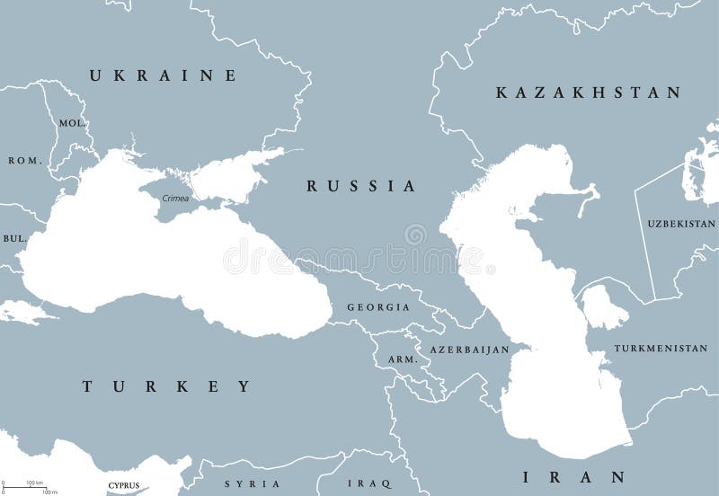
Free with trial Black Sea and Caspian Sea region political map with countries, borders and English labeling. Bodies of water between Eastern Europe and Western Asia. Gray illustration. Vector. Marmara vectors Black Sea and Caspian Sea region political map. With countries, borders and English labeling. Bodies of water between Eastern Europe and Western Asia. Gray
Free with trial City map Istanbul, monochrome detailed plan, vector illustration. Istanbul city plan, detailed vector map detailed plan of the city, rivers and streets. Marmara vectors City map Istanbul, monochrome detailed plan, vector illustration. Istanbul city plan, detailed vector map detailed plan of the city, rivers and streets
Free with trial The Mediterranean Sea subdivisions, political map with straits, countries and the Black Sea. Connected to the Atlantic Ocean, surrounded by the Mediterranean Basin, almost completely enclosed by land. Marmara vectors Mediterranean Sea subdivisions, political map, with the Black Sea. The Mediterranean Sea subdivisions, political map with straits, countries and the Black Sea. The Mediterranean Sea subdivisions, political map with straits, countries and the Black Sea. Connected to the Atlantic Ocean, surrounded by the Mediterranean Basin, almost completely enclosed by land.
Free with trial Black Sea and Sea of Azov region political map with capitals and borders. Body of water between Eastern Europe and Western Asia. Illustration. Gray illustration. Vector. Marmara vectors Black Sea and Sea of Azov region political map. With capitals and borders. Body of water between Eastern Europe and Western Asia. Illustration. Gray
Free with trial City map Istanbul, color detailed plan, vector illustration. Istanbul city plan, detailed vector map detailed plan of the city, rivers and streets. Marmara vectors City map Istanbul, color detailed plan, vector illustration. Istanbul city plan, detailed vector map detailed plan of the city, rivers and streets
Free with trial The Mediterranean Sea, political map with subdivisions, straits, islands and countries. Connected to the Atlantic Ocean, surrounded by the Mediterranean Basin, almost completely enclosed by land. Marmara vectors The Mediterranean Sea, political map with subdivisions. Straits, islands and countries. Connected to the Atlantic Ocean, surrounded by the Mediterranean Basin. The Mediterranean Sea, political map with subdivisions, straits, islands and countries. Connected to the Atlantic Ocean, surrounded by the Mediterranean Basin, almost completely enclosed by land.
Free with trial Aegean Sea region with Aegean Islands,political map. An elongated embayment of the Mediterranean Sea,located between Europe and Asia,and between the Balkans and Anatolia,Greece and Turkey. Vector. Marmara vectors Aegean Sea region, with Aegean Islands, political map. Aegean Sea region with Aegean Islands,political map. An elongated embayment of the Mediterranean Sea. Aegean Sea region with Aegean Islands,political map. An elongated embayment of the Mediterranean Sea,located between Europe and Asia,and between the Balkans and Anatolia,Greece and Turkey. Vector.
Free with trial Vector city map of Istanbul in black and white. Vector map of Istanbul in black and white, city map simple style. Marmara vectors Vector city map of Istanbul in black and white. Vector map of Istanbul in black and white, city map simple style
Free with trial Map of the Aegean, part of the Mediterranean between Greece and Turkey. Marmara vectors Map of the Aegean, part of the Mediterranean between Greece and Turkey.
Free with trial Vector map of Turkey with regions and geographical divisions. Editable and clearly labeled layers. Marmara vectors Vector map of Turkey with regions and geographical divisions. Editable and clearly labeled layers
Free with trial Set of 16 people avatars in flat / material design style. Marmara vectors Flat design avatars. Set of 16 people avatars in flat / material design style. Set of 16 people avatars in flat / material design style.
Free with trial Drawing sketch illustration of the Maiden`s Tower, the tower on an islet in the middle of the Bosphorus, Istanbul. Marmara vectors Drawing sketch illustration of the Maiden`s Tower. The tower on an islet in the middle of the Bosphorus, Istanbul
Free with trial Drawing sketch illustration of Ortakoy Mosque. Drawing sketch illustration of Buyuk Mecidiye Mosque or Ortakoy Mosque along the Bosphorus, Istanbul. Marmara vectors Drawing sketch illustration of Ortakoy Mosque. Drawing sketch illustration of Buyuk Mecidiye Mosque or Ortakoy Mosque along the Bosphorus, Istanbul
Free with trial Drawing sketch illustration of Tophane-i Amire, an old Ottoman army building overlooking the Bosphorus. Marmara vectors Drawing sketch illustration of Tophane-i Amire. An old Ottoman army building overlooking the Bosphorus
Free with trial Drawing sketch illustration of Beylerbeyi Palace Palace of the Lord of the Lords, an old Ottoman imperial summer residence in Uskudar, Asian side of the Bosphorus, Istanbul. Marmara vectors Drawing sketch illustration of Beylerbeyi Palace. Palace of the Lord of the Lords, an old Ottoman imperial summer residence in Uskudar, Asian side of the
Free with trial Drawing sketch illustration of Beylerbeyi Palace Palace of the Lord of the Lords, an old Ottoman imperial summer residence in Uskudar, Asian side of the Bosphorus, Istanbul. Marmara vectors Drawing sketch illustration of Beylerbeyi Palace. Palace of the Lord of the Lords, an old Ottoman imperial summer residence in Uskudar, Asian side of the
Free with trial Drawing sketch illustration of Haydarpasa Dock and a ferry on the coast of the Bosphorus in Kadikoy, Istanbul. Marmara vectors Drawing sketch illustration of Haydarpasa, Kadikoy, Istanbul. Drawing sketch illustration of Haydarpasa Dock and a ferry on the coast of the Bosphorus in Kadikoy. Drawing sketch illustration of Haydarpasa Dock and a ferry on the coast of the Bosphorus in Kadikoy, Istanbul
Free with trial Cityscape view Beyglou district and the old town with the Galata Tower in Istanbul, graphic sketch illustration. Marmara vectors Cityscape view Beyglou district with the Galata Tower in Istanbul, graphic sketch illustration. Cityscape view Beyglou district and the old town with the Galata. Cityscape view Beyglou district and the old town with the Galata Tower in Istanbul, graphic sketch illustration
Free with trial Drawing sketch illustration of Tophane-i Amire, an old Ottoman army building overlooking the Bosphorus. Marmara vectors Drawing sketch illustration of Tophane-i Amire. An old Ottoman army building overlooking the Bosphorus
Free with trial Drawing sketch illustration of Tophane-i Amire, an old Ottoman army building overlooking the Bosphorus. Marmara vectors Drawing sketch illustration of Tophane-i Amire. An old Ottoman army building overlooking the Bosphorus
Free with trial Istanbul architecture vector city skyline, black cityscape with landmarks, isolated sights on background. Marmara vectors Istanbul architecture vector city skyline, travel cityscape with landmarks, buildings, isolated sights on background. Istanbul architecture vector city skyline. Istanbul architecture vector city skyline, black cityscape with landmarks, isolated sights on background
Free with trial Invitation card templates with golden, black and white abstract painted decor. Marble textured brochure background. EPS 10 vector. Set. Marmara vectors Invitation card templates with golden, black and white abstract painted decor. Marble textured brochure background. EPS 10 vector. Set
Free with trial Istanbul maiden tower. Isolated istanbul maiden tower with vector style. Marmara vectors Istanbul maiden tower. Isolated istanbul maiden tower with vector style
Free with trial Map of Turkey with Regions. Vector map of Turkey with named regions and travel icons. Marmara vectors Map of Turkey with Regions. Vector map of Turkey with named regions and travel icons
Free with trial GreeceGreece administrative divisions map. Flag of Greece. Athens cityscape. Vector illustration. Athens. Marmara vectors GreeceGreece administrative divisions map. Flag of Greece. Athens cityscape. Vector illustration. Greece administrative divisions map. Flag of Greece. Athens
Free with trial Detailed vector map of regions of Turkey with flag, for your design. Marmara vectors Detailed vector map of regions of Turkey with flag. For your design
Free with trial Vector silhouette of Bosphorus Strait scape against sunset sky. Marmara vectors Vector silhouette of Bosphorus Strait scape against sunset sky. Silhouette of Bosphorus Strait scape against sunset sky
Free with trial Marmara Region of Turkey map symbol shape, travel web concept icon vector illustration. Marmara vectors Marmara Region of Turkey map symbol shape, travel web concept icon vector illustration.
Free with trial Marmara Region of Turkey map symbol shape, travel web concept icon vector illustration. Marmara vectors Marmara Region of Turkey map symbol shape, travel web concept icon vector illustration.
Free with trial Marmara Region of Turkey map symbol shape, travel web concept icon vector illustration. Marmara vectors Marmara Region of Turkey map symbol shape, travel web concept icon vector illustration.
Free with trial Marmara Region of Turkey map symbol shape, travel web concept icon vector illustration. Marmara vectors Marmara Region of Turkey map symbol shape, travel web concept icon vector illustration.
Free with trial Turkey, geographical regions, colored political map. The seven regions and their largest city: Aegean, Black Sea, Marmara, Mediterranean, and Central, Eastern, and Southeastern Anatolia Region. Vector. Marmara vectors Turkey, geographical regions, colored political map. The seven regions and their largest city: Aegean, Black Sea, Marmara, Mediterranean, and Central, Eastern
Free with trial Turkey, Republic of Türkiye, political map, with capital Ankara, and largest cities. Country mainly located in Anatolia in West Asia, with smaller part called East Thrace in Southeast Europe. Vector. Marmara vectors Turkey, Republic of Türkiye, political map, with capital Ankara. And largest cities. Country mainly located in Anatolia in West Asia, with smaller part called. Turkey, Republic of Türkiye, political map, with capital Ankara, and largest cities. Country mainly located in Anatolia in West Asia, with smaller part called East Thrace in Southeast Europe. Vector
Free with trial Turkey, Republic of Türkiye, gray political map, with capital Ankara, and largest cities. Country mainly located in Anatolia in West Asia, with smaller part East Thrace in Southeast Europe. Vector. Marmara vectors Turkey, Republic of Türkiye, gray political map, with capital Ankara. And largest cities. Country mainly located in Anatolia in West Asia, with smaller part. Turkey, Republic of Türkiye, gray political map, with capital Ankara, and largest cities. Country mainly located in Anatolia in West Asia, with smaller part East Thrace in Southeast Europe. Vector
Free with trial Vector map of Turkey in vintage style with regions and geographical divisions, and neighbouring countries. Editable and clearly labeled layers. National Maps Series. Marmara vectors Vector map of Turkey in vintage style with regions and geographical divisions, and neighbouring countries. Editable and clearly labeled layers. National Maps
Free with trial Vector blank map of Turkey in vintage style with regions and geographical divisions, and neighbouring countries. Editable and clearly labeled layers. National Maps Series. Marmara vectors Vector blank map of Turkey in vintage style with regions and geographical divisions, and neighbouring countries. Editable and clearly labeled layers. National
Free with trial Administrative district map of the Turkish city of Istanbul. Marmara vectors Administrative district map of the Turkish city of Istanbul.
Free with trial Map of the Republic of Turkey, Asia, Europe. Marmara vectors Map of the Republic of Turkey, Asia, Europe.
Free with trial Turkey region silhouettes set and blank map of the country isolated on white background. Vector illustration design. Marmara vectors Turkey region silhouettes set and blank map of the country isolated on white background. Vector illustration design
Free with trial Turkiye skyline silhouette in colorful geometric style. Symbol for your design. Vector illustration. Marmara vectors Turkiye skyline silhouette in colorful geometric style. Symbol for your design. Vector illustration
Free with trial Turkey political map of administrative divisions - provinces. Grey blank vector editable map EPS. Marmara vectors Turkey editable vector political map EPS. Turkey political map of administrative divisions - provinces. Grey blank vector editable map EPS. Turkey political map of administrative divisions - provinces. Grey blank vector editable map EPS.
Free with trial City bridge with traffic silhouette icon isolated on white background. Marmara vectors City bridge with traffic silhouette. Icon isolated on white background
Free with trial A clean, minimalist black outline of the geographical shape of Turkey on a white background. This vector graphic is ideal for educational materials, travel guides, or design projects requiring a clear representation of the country's borders. Its simplicity makes it highly versatile for various applications, from digital presentations to print media. The image focuses solely on the country's silhouette, devoid of any internal details or color. Marmara vectors Outline Map of Turkey - Simple Black and White Vector. A clean, minimalist black outline of the geographical shape of Turkey on a white background. This vector. A clean, minimalist black outline of the geographical shape of Turkey on a white background. This vector graphic is ideal for educational materials, travel guides, or design projects requiring a clear representation of the country's borders. Its simplicity makes it highly versatile for various applications, from digital presentations to print media. The image focuses solely on the country's silhouette, devoid of any internal details or color.
Free with trial Vector map of the European part of Türkiye, Eastern Thrace. Marmara vectors Vector map of the European part of Türkiye, Eastern Thrace.
Free with trial Green Skyline panorama of city of Izmir, Turkiye - vector illustration. Marmara vectors Green Skyline panorama of city of Izmir, Turkiye. Vector illustration
Free with trial Green Skyline panorama of city of Bursa, Turkiye - vector illustration. Marmara vectors Green Skyline panorama of city of Bursa, Turkiye. Vector illustration
Free with trial Istanbul outline map. Isolated on white background, Turkey. Marmara vectors Istanbul outline map. Isolated on white background, Turkey
Free with trial Love Izmir quote card. Modern, simple, minimal typographic design. Isolated on white background. Marmara vectors Love Izmir quote card. Modern, simple, minimal typographic design. Isolated on white background.
Free with trial Love Sinop quote card. Modern, simple, minimal typographic design. Isolated on white background. Marmara vectors Love Sinop quote card. Modern, simple, minimal typographic design. Isolated on white background.
Free with trial Warning sign icon, earthquake prone danger - warning area on yellow rhombus board. Marmara vectors Warning sign icon, earthquake prone danger. Warning area on yellow rhombus board
Free with trial Warning sign icon, earthquake and landslide prone houses - warning area on yellow rhombus board. Marmara vectors Warning sign icon, earthquake and landslide prone houses. Warning area on yellow rhombus board
 Sign in