Free with trial City pattern. Seamless pattern with city silhouette. Municipality vectors City pattern. Seamless pattern with city silhouette
Free with trial Silhouette of town, roofs, houses and tree. Line art. Black and white vector icon. Conceptual vector illustration. Municipality vectors Town with greenery, house and tree, vector illustration, eps. Silhouette of town, roofs, houses and tree.Line art. Black and white vector icon. Conceptual. Silhouette of town, roofs, houses and tree.Line art. Black and white vector icon. Conceptual vector illustration.
Free with trial Highly detailed map of Italy with all different regions selectable individual. Municipality vectors Political map of Italy. Highly detailed map of Italy with all different regions selectable individual. Highly detailed map of Italy with all different regions selectable individual.
Free with trial Cartoon Garbage Truck. Isolated on white background. Available EPS-10 vector format separated by groups and layers for easy edit. Municipality vectors Cartoon Garbage Truck. Isolated on white background. Available EPS-10 vector format separated by groups and layers for easy edit
Free with trial Tennessee state road map with Interstates, U. S. Highways and state roads. All elements on separate layers for easy editing. Municipality vectors Tennessee State Interstate Map. Tennessee state road map with Interstates, U.S. Highways and state roads. All elements on separate layers for easy editing. Tennessee state road map with Interstates, U.S. Highways and state roads. All elements on separate layers for easy editing.
Free with trial Neighbourhood town with school abuildings and trees (sitting around illusion of globe). Municipality vectors Stylized Neighborhood around globe. Neighbourhood town with school abuildings and trees (sitting around illusion of globe. Neighbourhood town with school abuildings and trees (sitting around illusion of globe)
Free with trial Missouri state road map with Interstates, U. S. Highways and state roads. All elements on separate layers for easy editing. Municipality vectors Missouri State Interstate Map. Missouri state road map with Interstates, U.S. Highways and state roads. All elements on separate layers for easy editing. Missouri state road map with Interstates, U.S. Highways and state roads. All elements on separate layers for easy editing.
Free with trial Vector map of China provinces colored by regions. Chinese names gives in parentheses. Municipality vectors Vector map of China provinces colored by regions. Chinese names gives in parentheses
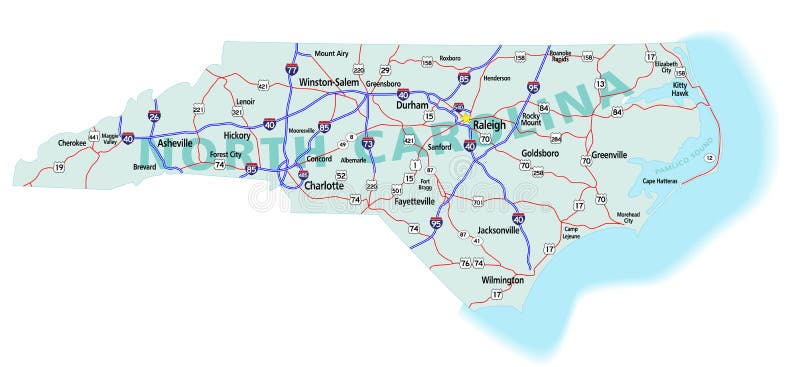
Free with trial North Carolina state road map with Interstates, U. S. Highways and state roads. All elements on separate layers (Fill, Roads, Cities, Outline) for easy editing. Map created December 3, 2009. ZIP File contains EPS-8 Adobe Illustrator file, Illustrator CS3 file, and large JPG file, 6806x3120. Source: Public domain National Planning Network ( and United States. Municipality vectors North Carolina State Interstate Map. North Carolina state road map with Interstates, U.S. Highways and state roads. All elements on separate layers (Fill. North Carolina state road map with Interstates, U.S. Highways and state roads. All elements on separate layers (Fill, Roads, Cities, Outline) for easy editing. Map created December 3, 2009. ZIP File contains EPS-8 Adobe Illustrator file, Illustrator CS3 file, and large JPG file, 6806x3120. Source: Public domain National Planning Network ( and United States
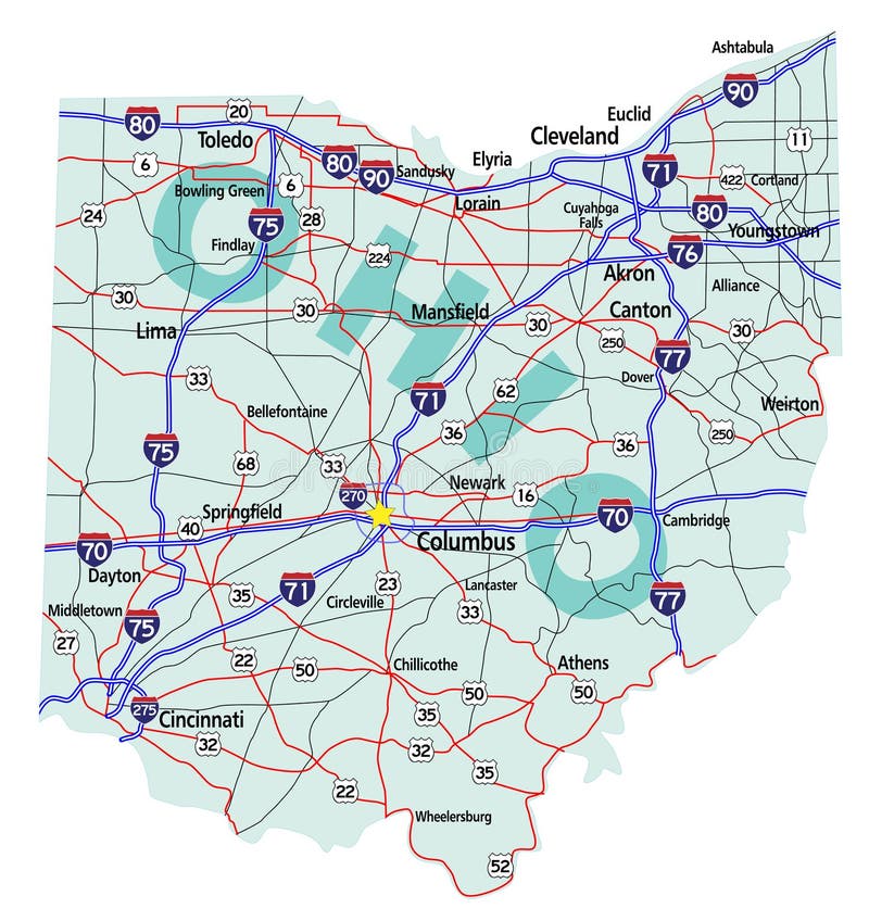
Free with trial Ohio state road map with Interstates, U. S. Highways and state roads. All elements on separate layers for easy editing. Map created November 26, 2009. ZIP File contains EPS-8 Adobefile,CS3 file, and large JPG file, 4469x4640. Source: Public domain National Planning Network ( and United States Federal Highway Administration (http:/. Municipality vectors Ohio State Interstate Map. Ohio state road map with Interstates, U.S. Highways and state roads. All elements on separate layers for easy editing. Map created. Ohio state road map with Interstates, U.S. Highways and state roads. All elements on separate layers for easy editing. Map created November 26, 2009. ZIP File contains EPS-8 Adobefile,CS3 file, and large JPG file, 4469x4640. Source: Public domain National Planning Network ( and United States Federal Highway Administration (http:/
Free with trial City pattern. Seamless background with colorful city silhouette. Municipality vectors City pattern. Seamless background with colorful city silhouette
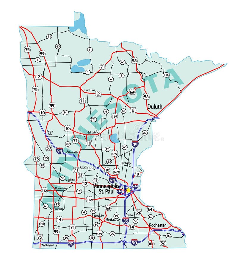
Free with trial Minnesota state road map with Interstates, U. S. Highways and state roads. All elements on separate layers for easy editing. Municipality vectors Minnesota State Interstate Map. Minnesota state road map with Interstates, U.S. Highways and state roads. All elements on separate layers for easy editing. Minnesota state road map with Interstates, U.S. Highways and state roads. All elements on separate layers for easy editing.
Free with trial Green city over globe. Funky stylized Green city over globe. Municipality vectors Green city over globe. Funky stylized Green city over globe
Free with trial Arizona state road map with Interstates, U. S. Highways and state roads. All elements on separate layers for easy editing. Municipality vectors Arizona State Interstate Map. Arizona state road map with Interstates, U.S. Highways and state roads. All elements on separate layers for easy editing. Arizona state road map with Interstates, U.S. Highways and state roads. All elements on separate layers for easy editing.
Free with trial New Jersey state road map with Interstates, U. S. Highways and state roads. All elements on separate layers for easy editing. Municipality vectors New Jersey State Interstate Map. New Jersey state road map with Interstates, U.S. Highways and state roads. All elements on separate layers for easy editing. New Jersey state road map with Interstates, U.S. Highways and state roads. All elements on separate layers for easy editing.
Free with trial Massachusetts state road map with Interstates, U. S. Highways and state roads. All elements on separate layers for easy editing. Municipality vectors Massachusetts State Interstate Map. Massachusetts state road map with Interstates, U. S. Highways and state roads. All elements on separate layers for easy. Massachusetts state road map with Interstates, U. S. Highways and state roads. All elements on separate layers for easy editing.
Free with trial Modern big city. vector illustration. Skyscrapers in a major city. Municipality vectors Modern big city. vector illustration. Skyscrapers in a major city. vector illustration
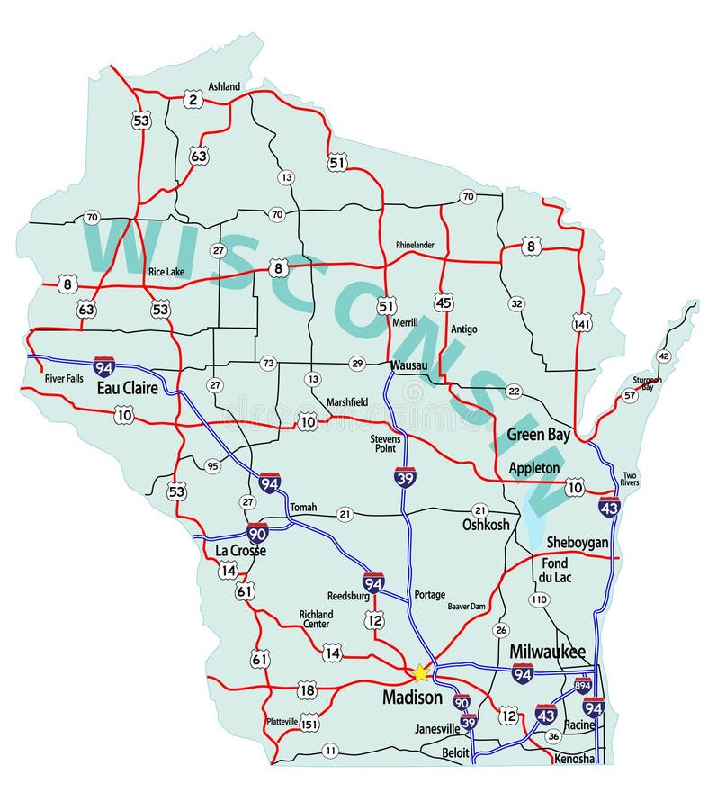
Free with trial Wisconsin state road map with Interstates, U. S. Highways and state roads. All elements on separate layers for easy editing. Municipality vectors Wisconsin State Interstate Map. Wisconsin state road map with Interstates, U.S. Highways and state roads. All elements on separate layers for easy editing. Wisconsin state road map with Interstates, U.S. Highways and state roads. All elements on separate layers for easy editing.
Free with trial Colorado state road map with Interstates, U. S. Highways and state roads. All elements on separate layers for easy editing. Municipality vectors Colorado State Interstate Map. Colorado state road map with Interstates, U.S. Highways and state roads. All elements on separate layers for easy editing. Colorado state road map with Interstates, U.S. Highways and state roads. All elements on separate layers for easy editing.
Free with trial Bonds company corporate funds financing. Vector paper. Municipality vectors Bonds company corporate funds financing. Vector paper
Free with trial Town, group of houses. Vector icon. Colored silhouette of houses with banch and tree. Municipality vectors Town, group of houses, vector illustration, village. Town, group of houses. Vector icon. Colored silhouette of houses with banch and tree. Town, group of houses. Vector icon. Colored silhouette of houses with banch and tree.
Free with trial The town, black silhouette on a white background. Decorative design, ector illustration. Municipality vectors Town, black silhouette of houses and church, decorative illustration, vector, eps. The town, black silhouette on a white background. Decorative design, ector. The town, black silhouette on a white background. Decorative design, ector illustration.
Free with trial Village, black silhouette. Night landscape. Group of houses and trees on hills. Municipality vectors Village, black silhouette, decorative poster, eps. Village, black silhouette. Night landscape. Group of houses and trees on hills. Village, black silhouette. Night landscape. Group of houses and trees on hills.
Free with trial Village, black silhouette, decorative design, eps. Village, houses and trees on the hill. Black silhouette on white background. Arc. Municipality vectors Village, black silhouette, decorative design, eps. Village, houses and trees on the hill. Black silhouette on white background. Arc
Free with trial Village, a lot of houses and trees. Color background. Decorative background, texture on white background. Municipality vectors Village, color background, border, template, banner, ps. Village, a lot of houses and trees. Color background. Decorative background, texture on white. Village, a lot of houses and trees. Color background. Decorative background, texture on white background.
Free with trial Road administrative map of the Romanian capital Bucharest. Road administrative and political map of the Romanian capital Bucharest. Municipality vectors Road administrative map of the Romanian capital Bucharest. Road administrative and political map of the Romanian capital Bucharest
Free with trial Map of the Golden Horseshoe metropolitan area around the western end of Lake Ontario, Ontario. Canada. Municipality vectors Map of the Golden Horseshoe metropolitan area around the western end of Lake Ontario Ontario Canada. Map of the Golden Horseshoe metropolitan area around the. Map of the Golden Horseshoe metropolitan area around the western end of Lake Ontario, Ontario. Canada
Free with trial Graphic representation of Social media Network. Municipality vectors Graphic representation of Social media Network. Graphic representation Social media Network
Free with trial China maps with markers. Set of the political China maps, markers and symbols for infographic. Municipality vectors China maps with markers. Set of the political China maps, markers and symbols for infographic
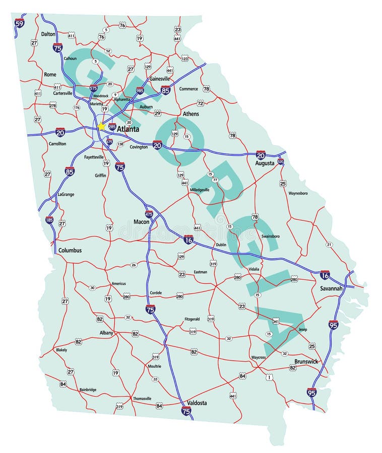
Free with trial Georgia state road map with Interstates, U. S. Highways and state roads. All elements on separate layers for easy editing. Map created December 1, 2009. ZIP File contains EPS-8 Adobe Illustrator file, Illustrator CS3 file, and large JPG file, 4212x5000. Source: Public domain National Planning Network ( and United States Federal Highway Administration (http:/. Municipality vectors Georgia State Interstate Map. Georgia state road map with Interstates, U.S. Highways and state roads. All elements on separate layers for easy editing. Map. Georgia state road map with Interstates, U.S. Highways and state roads. All elements on separate layers for easy editing. Map created December 1, 2009. ZIP File contains EPS-8 Adobe Illustrator file, Illustrator CS3 file, and large JPG file, 4212x5000. Source: Public domain National Planning Network ( and United States Federal Highway Administration (http:/
Free with trial Map european capitals by population. Vector map of europe with capital cities with more than 100000 inhabitants. Municipality vectors Map european capitals by population. Vector map of europe with capital cities with more than 100000 inhabitants
Free with trial Town - 1. Road is drawn in modern city. Night. A vector illustration. Municipality vectors Town - 1. Road is drawn in modern city. Night. A vector illustration
Free with trial Image of a colorful retro city skyline. Municipality vectors Retro City Skyline. Image of a colorful retro city skyline. Image of a colorful retro city skyline.
Free with trial Facade of Old Western Frontier Town. Old western frontier town with hotel jail saloon bank and supply store. Municipality vectors Facade of Old Western Frontier Town. Old western frontier town with hotel jail saloon bank and supply store
Free with trial Taipei, capital city and a special municipality of Taiwan. Municipality vectors Taipei. Capital city and a special municipality of Taiwan
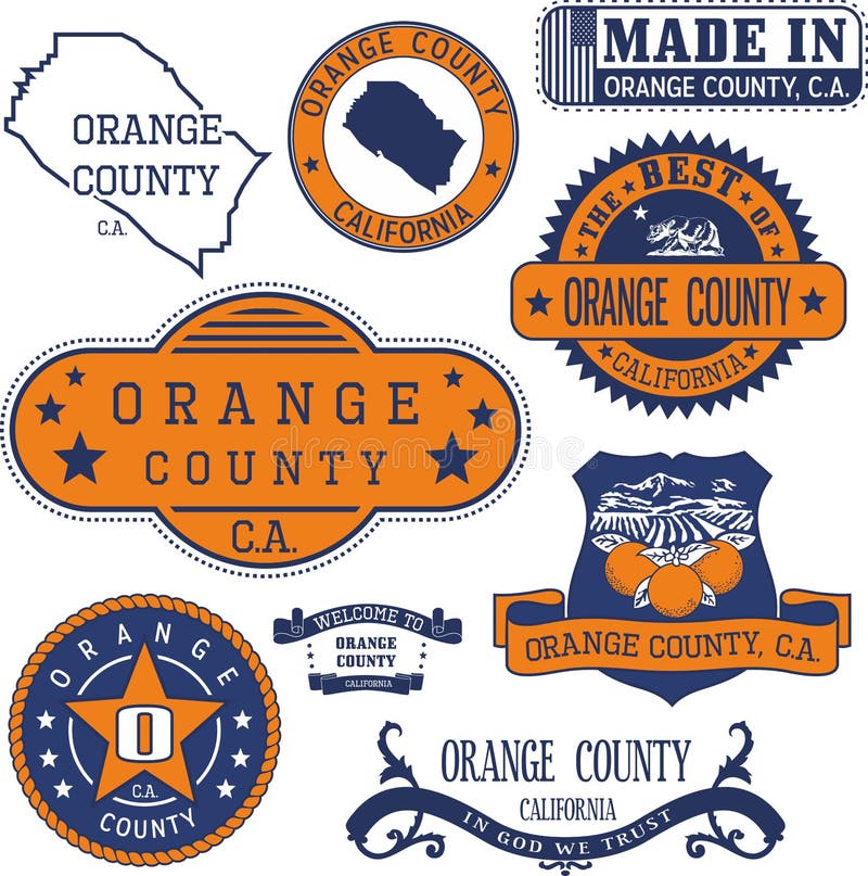
Free with trial Orange county, California. Set of generic stamps and signs including Orange county map and seal elements. Municipality vectors Orange county, CA. Set of stamps and signs. Orange county, California. Set of generic stamps and signs including Orange county map and seal elements. Orange county, California. Set of generic stamps and signs including Orange county map and seal elements.
Free with trial City icons set. signs and symbols. City. set of black icons on gray background. vector illustration. Municipality vectors City icons set. signs and symbols. City. set of black icons on gray background. vector illustration
Free with trial Parking pay station. Payment by credit card at parking pay station. Municipality vectors Parking pay station. Payment by credit card at parking pay station
Free with trial New York City. Set of generic stamps and signs. Municipality vectors New York City, generic stamps and signs. New York City. Set of generic stamps and signs. New York City. Set of generic stamps and signs.
Free with trial Generic stamps and signs of Oakland city, CA. Set of generic stamps and signs of Oakland city, California. Municipality vectors Generic stamps and signs of Oakland city, CA. Set of generic stamps and signs of Oakland city, California
Free with trial Pittsburgh city, Pennsylvania. Set of generic stamps and signs. Municipality vectors Pittsburgh city, PA, generic stamps and signs. Pittsburgh city, Pennsylvania. Set of generic stamps and signs. Pittsburgh city, Pennsylvania. Set of generic stamps and signs.
Free with trial Maryland state road map with Interstates, U. S. Highways and state roads. All elements on separate layers for easy editing. Municipality vectors Maryland State Interstate Map. Maryland state road map with Interstates, U.S. Highways and state roads. All elements on separate layers for easy editing. Maryland state road map with Interstates, U.S. Highways and state roads. All elements on separate layers for easy editing.
Free with trial Bank and museum city buildings isometric decorative icons set with pillars and elements in style of classicism vector illustration. Municipality vectors Bank And Museum Buildings Isometric Icons. Bank and museum city buildings isometric decorative icons set with pillars and elements in style of classicism vector. Bank and museum city buildings isometric decorative icons set with pillars and elements in style of classicism vector illustration
Free with trial Generic stamps and signs of Bakersfield city, CA. Set of generic stamps and signs of Bakersfield city, California. Municipality vectors Generic stamps and signs of Bakersfield city, CA. Set of generic stamps and signs of Bakersfield city, California
Free with trial Cartoon Garbage Truck. Isolated on white background. Available EPS-10 vector format separated by groups and layers for easy edit. Municipality vectors Cartoon Garbage Truck. Isolated on white background. Available EPS-10 vector format separated by groups and layers for easy edit
Free with trial City, town icons set. signs and symbols. City. Set of icons on a white background. vector illustration. Municipality vectors City, town icons set. signs and symbols. City. Set of icons on a white background. vector illustration
Free with trial Generic stamps and signs of Lackawanna county, PA. Set of generic stamps and signs of Lackawanna county, Pennsylvania. Municipality vectors Generic stamps and signs of Lackawanna county, PA. Set of generic stamps and signs of Lackawanna county, Pennsylvania
Free with trial Generic stamps and signs of Staten Island borough, NYC. Set of generic stamps and signs of Staten Island borough, New York City. Municipality vectors Generic stamps and signs of Staten Island borough, NYC. Set of generic stamps and signs of Staten Island borough, New York City
Free with trial City architecture public government building. Isometric museum building. Exterior of Museum building with title and. Columns. Vector Illustration. Municipality vectors City architecture public government building. Isometric museum building. Exterior of Museum building with title and. Columns. Vector Illustration
Free with trial Shanghai and the Yangtze River Delta, political map with major cities. Megalopolis of China, located where the Yangtze River drains into the East China Sea, with Hangzhou Bay and Zhoushan Archipelago. Municipality vectors Shanghai and the Yangtze River Delta, political map with major cities. Megalopolis of China, located where the Yangtze River drains into the East China Sea
Free with trial Silhouette of town, vector icon. Contour drawing of high houses. Black illustration of houses with white windows. Municipality vectors Silhouette of town, black vector icon, banner, eps. Silhouette of town, vector icon. Contour drawing of high houses. Black illustration of houses with white. Silhouette of town, vector icon. Contour drawing of high houses. Black illustration of houses with white windows.
Free with trial Cityscape, black silhouette of town, vector icon. Group of prefab houses, lamp and trees. Creative isolated object. Municipality vectors Cityscape, town with trees and lamp, black silhouette of town, vector icon, eps. Cityscape, black silhouette of town, vector icon. Group of prefab houses, lamp. Cityscape, black silhouette of town, vector icon. Group of prefab houses, lamp and trees. Creative isolated object.
Free with trial Electronic documents and digital government concept. Online business, getting official papers through internet, web service, technology. Flat vector illustration isolated on white background. Municipality vectors Electronic documents and digital government concept. Online business, getting official papers through internet, web. Service, technology. Flat vector. Electronic documents and digital government concept. Online business, getting official papers through internet, web service, technology. Flat vector illustration isolated on white background.
Free with trial Democratic elections. Hand voting in a ballot box. Municipality vectors Democratic elections. Hand voting in a ballot box
Free with trial Greater Vancouver map and municipalities, simple map. British Columbia, Canada. Tourist map or guide of Metro Vancouver BC. A simple grey scale map without text. Municipality vectors Greater Vancouver map and municipalities, simple map. British Columbia, Canada. Tourist map or guide of Metro Vancouver BC. A simple grey scale map without text
Free with trial Krakow map with roads and rivers, city municipality administrative borders, art design with grey and blue on white background. Municipality vectors Map of Krakow city within administrative borders with roads and rivers on white background. Krakow map with roads and rivers, city municipality administrative. Krakow map with roads and rivers, city municipality administrative borders, art design with grey and blue on white background
Free with trial Black simple detailed street roads map on vintage beige background of the neighbourhood sixième, 6th arrondissement of Paris, France. Municipality vectors Street roads map of the sixième, 6th arrondissement of Paris, France. Black simple detailed street roads map on vintage beige background of the neighbourhood. Black simple detailed street roads map on vintage beige background of the neighbourhood sixième, 6th arrondissement of Paris, France
Free with trial Blank map of Puerto Rico. High quality map Commonwealth of Puerto Rico with provinces on transparent background for your web site design, logo, app, UI. America. EPS10. Municipality vectors Blank map of Puerto Rico. High quality map Commonwealth of Puerto Rico with provinces on transparent background for your web site. Design, logo, app, UI
Free with trial Massachusetts state map, USA. Set of Massachusetts maps with outline border, counties and US states map. Black and white color. Vector illustration. Municipality vectors Massachusetts state map, USA. Set of Massachusetts maps with outline border, counties and US states map. Black and white color. Vector illustration
Free with trial Lithuania maps with markers. Set of the political Lithuania maps, markers and symbols for infographic. Municipality vectors Lithuania maps with markers. Set of the political Lithuania maps, markers and symbols for infographic
Free with trial Latvia maps with markers. Set of the political Latvia maps, markers and symbols for infographic. Municipality vectors Latvia maps with markers. Set of the political Latvia maps, markers and symbols for infographic
Free with trial Silhouette of the Russkiy Russian cable-stayed bridge in Vladivostok, Russia, with the city coat of arms and the city name in Russian. Municipality vectors Silhouette of Russkiy bridge in Vladivostok, Russia. Silhouette of the Russkiy Russian cable-stayed bridge in Vladivostok, Russia, with the city coat of arms and. Silhouette of the Russkiy Russian cable-stayed bridge in Vladivostok, Russia, with the city coat of arms and the city name in Russian
Free with trial Estonia maps with markers. Set of the political Estonia maps, markers and symbols for infographic. Municipality vectors Estonia maps with markers. Set of the political Estonia maps, markers and symbols for infographic
Free with trial India maps with markers. Set of the political India maps, markers and symbols for infographic. Municipality vectors India maps with markers. Set of the political India maps, markers and symbols for infographic
Free with trial Vector map of Portugal districts and autonomous regions, subdivided into municipalities. Each region have own color palette. Flag of Portugal. Municipality vectors Vector map of Portugal districts and autonomous regions, subdivided into municipalities. Each region have own color palette. Flag. Of Portugal
Free with trial Ekrem Imamoglu, Mayor of Istanbul Metropolitan Municipality, Turkey. Vector illustration. Municipality vectors Ekrem Imamoglu portrait, Mayor of Istanbul Metropolitan Municipality, Turkey. Ekrem Imamoglu, Mayor of Istanbul Metropolitan Municipality, Turkey. Vector. Ekrem Imamoglu, Mayor of Istanbul Metropolitan Municipality, Turkey. Vector illustration
Free with trial Municipality authority with administrative buildings set tiny person concept. Hospital, town hall, church, fire or bus station and police department as government public buildings vector illustration. Municipality vectors Municipality authority with administrative buildings set tiny person concept. Hospital, town hall, church, fire or bus station and police department as
Free with trial Porto Alegre city Brazil municipality vector map. Green street map, municipality area, white lines. Urban skyline panorama for tourism. Municipality vectors Porto Alegre city Brazil municipality vector map. Green street map, municipality area. Urban skyline panorama for tourism. Porto Alegre city Brazil municipality. Porto Alegre city Brazil municipality vector map. Green street map, municipality area, white lines. Urban skyline panorama for tourism
Free with trial Location Map of Beijing Municipality. Black Location Map of Chinese Municipality of Beijing within Grey Map of China. Municipality vectors Location Map of Beijing Municipality. Black Location Map of Chinese Municipality of Beijing within Grey Map of China
Free with trial Black simple detailed street roads map on vintage beige background of the neighbourhood Municipio VI – Roma Delle Torri municipality of Rome Italy. Municipality vectors Street roads map of the Municipio VI – Roma Delle Torri municipality of Rome Italy. Black simple detailed street roads map on vintage beige background of the. Black simple detailed street roads map on vintage beige background of the neighbourhood Municipio VI – Roma Delle Torri municipality of Rome Italy
Free with trial Detailed navigation urban street roads map on vintage beige background of the Danish capital city of Copenhagen Municipality, Denmark. Municipality vectors Street roads map of Copenhagen Municipality, Denmark. Detailed navigation urban street roads map on vintage beige background of the Danish capital city of. Detailed navigation urban street roads map on vintage beige background of the Danish capital city of Copenhagen Municipality, Denmark
Free with trial Municipality of Budapest Hungary, Hungarian counties map vector illustration, scribble sketch Budapest map,. Municipality vectors Municipality of Budapest Hungary, Hungarian counties map vector illustration, scribble sketch Budapest map.
Free with trial Porto Alegre map city poster, horizontal background vector map with opacity title. Municipality area street map. Widescreen. Brazilian skyline panorama. Municipality vectors Porto Alegre map city poster, horizontal background vector map with opacity title. Municipality area street map. Widescreen. Brazilian skyline panorama
Free with trial Hangzhou city vector map poster. China municipality square linear street map, administrative municipal area, white lines on black background, with title. Municipality vectors Hangzhou city vector map poster. China municipality square linear street map, administrative municipal area. White lines on black background, with title
Free with trial Ahmedabad map city poster province, green horizontal background vector map. Municipality area road map. Widescreen India skyline panorama. Municipality vectors Ahmedabad map city poster province, green horizontal background vector map. Municipality area road map. Widescreen skyline. Ahmedabad map city poster province. Ahmedabad map city poster province, green horizontal background vector map. Municipality area road map. Widescreen India skyline panorama
Free with trial Manama map city poster province, blue horizontal background vector map. Municipality area road map. Widescreen Bahrain capital skyline panorama. Municipality vectors Manama map city poster province, blue horizontal background vector map. Municipality area road map. Widescreen skyline panorama. Manama map city poster province. Manama map city poster province, blue horizontal background vector map. Municipality area road map. Widescreen Bahrain capital skyline panorama
Free with trial Black location map of the Vesterbro/Kongens Enghave District inside gray urban districts map of the Danish capital city of Copenhagen Municipality, Denmark. Municipality vectors Location map of the Vesterbro/Kongens Enghave District of Copenhagen Municipality, Denmark. Black location map of the Vesterbro/Kongens Enghave District inside. Black location map of the Vesterbro/Kongens Enghave District inside gray urban districts map of the Danish capital city of Copenhagen Municipality, Denmark
Free with trial Municipality icon line design. Building, Government, Administration, Town Hall, City Hall, Civic, Municipal vector illustration. Municipality editable stroke icon. Municipality vectors Municipality icon line design. Building, Government, Administration, Town Hall, City Hall, Civic, Municipal vector. Illustration. Municipality editable stroke
Free with trial Urk municipality. (Kingdom of the Netherlands, Holland, Flevoland province) map vector illustration, scribble sketch Urk map. Municipality vectors Urk municipality. (Kingdom of the Netherlands, Holland, Flevoland province) map vector illustration, scribble sketch Urk map
Free with trial City line icons signs set. Design collection of urban, metropolis, municipality, settlement, town, village, borough, zone outline vector concept illustrations. Municipality vectors City line icons signs set. Design collection of urban, metropolis, municipality, settlement, town, village, borough. Zone outline vector concept illustrations
 Sign in