Free with trial Competition. Running people symbolizing competition in business life. Scaling vectors Competition. Running people symbolizing competition in business life
Free with trial Europe single states political map. All countries in different colors, with national borders and country names. English labeling and scaling. Illustration on white background. Scaling vectors Europe single states political map. All countries in different colors, with national borders and country names. English labeling and scaling. Illustration on
Free with trial China political map with capital Beijing, national borders, important cities, rivers and lakes. English labeling and scaling. Illustration. Scaling vectors China Political Map. With capital Beijing, national borders, important cities, rivers and lakes. English labeling and scaling. Illustration
Free with trial Antarctica Political Map with south pole, scientific research stations and ice shelfs. English labeling and scaling. Illustration. Scaling vectors Antarctica Political Map. With south pole, scientific research stations and ice shelfs. English labeling and scaling. Illustration
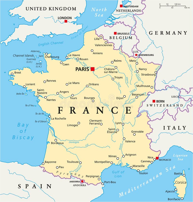
Free with trial France Political Map with capital Paris, national borders, most important cities and rivers. English labeling and scaling. Illustration. Scaling vectors France Political Map. With capital Paris, national borders, most important cities and rivers. English labeling and scaling. Illustration
Free with trial Israel political map with capital Jerusalem, national borders, important cities, rivers and lakes. English labeling and scaling. Illustration. Scaling vectors Israel Political Map. With capital Jerusalem, national borders, important cities, rivers and lakes. English labeling and scaling. Illustration
Free with trial Region of lands around the Mediterranean Sea. South Europe, North Africa and Near East with capitals, national borders, rivers and lakes. English labeling and scaling. Illustration. Scaling vectors Mediterranean Sea Region Political Map. Region of lands around the Mediterranean Sea. South Europe, North Africa and Near East with capitals, national borders. Region of lands around the Mediterranean Sea. South Europe, North Africa and Near East with capitals, national borders, rivers and lakes. English labeling and scaling. Illustration.
Free with trial Dry skin. Medical illustration of the effects of dry skin. Scaling vectors Dry skin. Medical illustration of the effects of dry skin
Free with trial Hispaniola Political Map with Haiti and Dominican Republic, located in the Caribbean island group, the Greater Antilles. With capitals, national borders, important cities, rivers and lakes. English labeling and scaling. Illustration. Scaling vectors Hispaniola Political Map with Haiti and Dominican Republic. Located in the Caribbean island group, the Greater Antilles. With capitals, national borders. Hispaniola Political Map with Haiti and Dominican Republic, located in the Caribbean island group, the Greater Antilles. With capitals, national borders, important cities, rivers and lakes. English labeling and scaling. Illustration.
Free with trial Ecuador and Galapagos Islands political map with capital Quito, with national borders, most important cities, rivers and lakes. Illustration with English labeling and scaling. Vector. Scaling vectors Ecuador and Galapagos Islands Political Map. With capital Quito, with national borders, most important cities, rivers and lakes. Illustration with English. Ecuador and Galapagos Islands political map with capital Quito, with national borders, most important cities, rivers and lakes. Illustration with English labeling and scaling. Vector.
Free with trial Graph paper background with vector blue plotting millimeter ruler line guide grid texture for engineering or mechanical drawing layout. Checkered A4 notebook, copybook background. Scaling vectors Graph paper background with vector blue plotting millimeter ruler line guide grid texture for engineering or mechanical drawing. Layout. Checkered A4 notebook
Free with trial Mountaineer illustration. An illustration of a mountaineer scaling a mountain. Scaling vectors Mountaineer illustration. An illustration of a mountaineer scaling a mountain
Free with trial Eczema. Medical illustration of the symptoms of eczema. Scaling vectors Eczema. Medical illustration of the symptoms of eczema
Free with trial Germany Political Map with capital Berlin, national borders, most important cities, rivers and lakes. English labeling and scaling. Illustration. Scaling vectors Germany Political Map. With capital Berlin, national borders, most important cities, rivers and lakes. English labeling and scaling. Illustration
Free with trial North Korea and South Korea political map with capitals Pyongyang and Seoul. Korean peninsula, national borders, important cities, rivers and lakes. English labeling and scaling. Illustration. Scaling vectors North Korea and South Korea Political Map. With capitals Pyongyang and Seoul. Korean peninsula, national borders, important cities, rivers and lakes. English. North Korea and South Korea political map with capitals Pyongyang and Seoul. Korean peninsula, national borders, important cities, rivers and lakes. English labeling and scaling. Illustration.
Free with trial Dry skin. Medical illustration of the effects of dry skin. Scaling vectors Dry skin. Medical illustration of the effects of dry skin
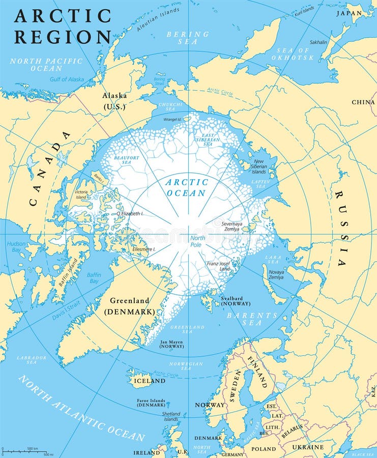
Free with trial Arctic region map with countries, capitals, national borders, rivers and lakes. Arctic Ocean with average minimum extent of sea ice. English labeling and scaling. Scaling vectors Arctic Region Map. With countries, capitals, national borders, rivers and lakes. Arctic Ocean with average minimum extent of sea ice. English labeling and
Free with trial Saudi Arabia political map with capital Riyadh, national borders and important cities. English labeling and scaling. Illustration. Scaling vectors Saudi Arabia Political Map. With capital Riyadh, national borders and important cities. English labeling and scaling. Illustration
Free with trial Vatican city political map. City state in Rome, Italy with national borders, important buildings, sights and gardens. English labeling and scaling. Illustration. Scaling vectors Vatican City Political Map. City state in Rome, Italy with national borders, important buildings, sights and gardens. English labeling and scaling
Free with trial Arctic region political map with countries, capitals, national borders, important cities, rivers and lakes. Arctic Ocean with average minimum extent of sea ice. English labeling and scaling. Scaling vectors Arctic Region Political Map. With countries, capitals, national borders, important cities, rivers and lakes. Arctic Ocean with average minimum extent of sea ice. Arctic region political map with countries, capitals, national borders, important cities, rivers and lakes. Arctic Ocean with average minimum extent of sea ice. English labeling and scaling.
Free with trial United States of America Political Map with capital Washington, national borders, most important cities, rivers and lakes. With single states, their borders and capitals, except Hawaii and Alaska. English labeling and scaling. Scaling vectors United States of America Political Map. With capital Washington, national borders, most important cities, rivers and lakes. With single states, their borders. United States of America Political Map with capital Washington, national borders, most important cities, rivers and lakes. With single states, their borders and capitals, except Hawaii and Alaska. English labeling and scaling.
Free with trial Political map of Peru with capital Lima, national borders, most important cities, rivers and lakes. Vector illustration with English labeling and scaling. Scaling vectors Peru Political Map. Political map of Peru with capital Lima, national borders, most important cities, rivers and lakes. Vector illustration with English labeling. Political map of Peru with capital Lima, national borders, most important cities, rivers and lakes. Vector illustration with English labeling and scaling.
Free with trial Dry skin. Simbolic medical illustration of the effects of dry skin. Scaling vectors Dry skin. Simbolic medical illustration of the effects of dry skin
Free with trial Ancient Egypt Map. Historical map of Ancient Egypt with most important sights, with rivers and lakes. Illustration with English labeling and scaling. Vector. Scaling vectors Ancient Egypt Map. Historical map of Ancient Egypt with most important sights, with rivers and lakes. Illustration with English labeling and scaling. Vector
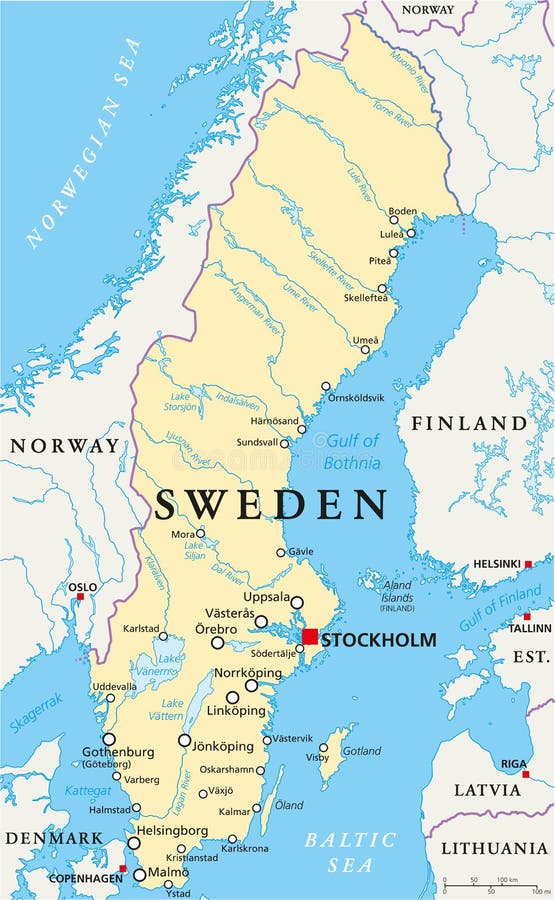
Free with trial Sweden Political Map with capital Stockholm, national borders, important cities, rivers and lakes. English labeling and scaling. Illustration. Scaling vectors Sweden Political Map. With capital Stockholm, national borders, important cities, rivers and lakes. English labeling and scaling. Illustration
Free with trial Russia political map with capital Moscow, national borders, important cities, rivers and lakes. English labeling and scaling. Illustration. Scaling vectors Russia Political Map. With capital Moscow, national borders, important cities, rivers and lakes. English labeling and scaling. Illustration
Free with trial Hungary political map with capital Budapest, national borders, important cities, rivers and lakes. English labeling and scaling. Illustration. Scaling vectors Hungary Political Map. With capital Budapest, national borders, important cities, rivers and lakes. English labeling and scaling. Illustration
Free with trial Tree climber. Young boy climbing up a tree. Scaling vectors Tree climber. Young boy climbing up a tree
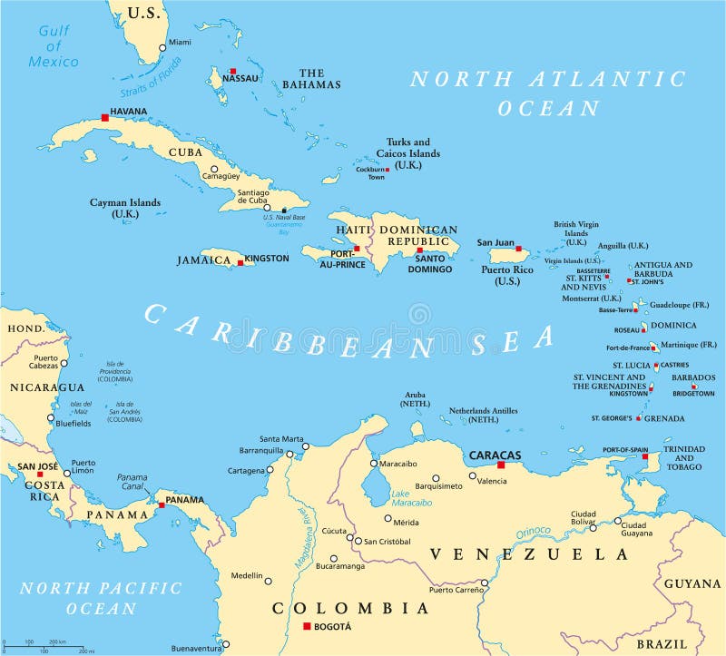
Free with trial Caribbean political map with capitals, national borders, important cities, rivers and lakes. English labeling and scaling. Illustration. Scaling vectors Caribbean Political Map. With capitals, national borders, important cities, rivers and lakes. English labeling and scaling. Illustration
Free with trial The Bahamas Political Map with capital Nassau, important cities and places. English labeling and scaling. Illustration. Scaling vectors The Bahamas Political Map. With capital Nassau, important cities and places. English labeling and scaling. Illustration
Free with trial Baltic States Political Map. Estonia, Latvia and Lithuania with capitals Tallinn, Riga and Vilnius. With national borders, important cities, rivers and lakes. English labeling and scaling. Scaling vectors Baltic States Political Map. Estonia, Latvia and Lithuania with capitals Tallinn, Riga and Vilnius. With national borders, important cities, rivers and lakes
Free with trial Mediterranean Basin Political Map. South Europe, North Africa and Near East with capitals, national borders, rivers and lakes. English labeling and scaling. Illustration. Scaling vectors Mediterranean Basin Political Map. South Europe, North Africa and Near East with capitals, national borders, rivers and lakes. English labeling and scaling
Free with trial Business management icons on white. Pack 04. Scaling vectors Business management icons. Pack 04. Business management icons on white. Pack 04. Business management icons on white. Pack 04.
Free with trial Poland Political Map with capital Warsaw, national borders, most important cities, rivers and lakes. English labeling and scaling. Illustration. Scaling vectors Poland Political Map. With capital Warsaw, national borders, most important cities, rivers and lakes. English labeling and scaling. Illustration
Free with trial Vietnam political map with capital Hanoi, national borders, important cities, rivers and lakes. English labeling and scaling. Illustration. Scaling vectors Vietnam Political Map. With capital Hanoi, national borders, important cities, rivers and lakes. English labeling and scaling. Illustration
Free with trial Baltic Sea area countries political map with national borders. Nations and states of Scandinavia. English labeling and scaling. Gray illustration on white background. Scaling vectors Baltic Sea area countries political map. With national borders. Nations and states of Scandinavia. English labeling and scaling. Gray illustration on white
Free with trial Netherlands Political Map with capital Amsterdam, national borders, most important cities, rivers and lakes. English labeling and scaling. Illustration. Scaling vectors Netherlands Political Map. With capital Amsterdam, national borders, most important cities, rivers and lakes. English labeling and scaling. Illustration
Free with trial Romania political map with capital Bucharest, national borders, important cities, rivers and lakes. English labeling and scaling. Illustration. Scaling vectors Romania Political Map. With capital Bucharest, national borders, important cities, rivers and lakes. English labeling and scaling. Illustration
Free with trial Political map of Malaysia and Indonesia with capitals Kuala Lumpur and Jakarta, with national borders and lakes. Vector illustration with English labeling and scaling. Scaling vectors Malaysia And Indonesia Political Map. Political map of Malaysia and Indonesia with capitals Kuala Lumpur and Jakarta, with national borders and lakes. Vector. Political map of Malaysia and Indonesia with capitals Kuala Lumpur and Jakarta, with national borders and lakes. Vector illustration with English labeling and scaling.
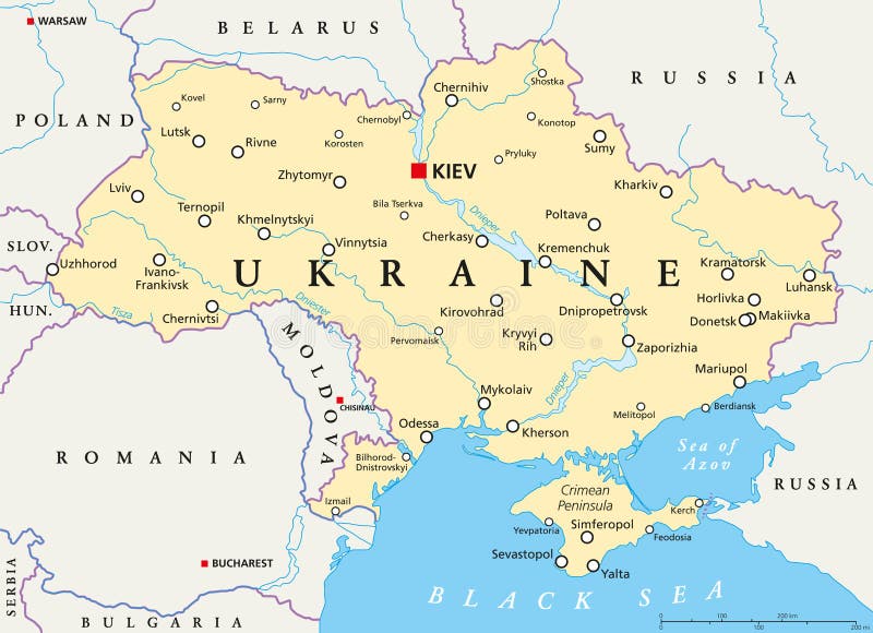
Free with trial Ukraine political map with capital Kiev, national borders, important cities, rivers and lakes. English labeling and scaling. Illustration. Scaling vectors Ukraine Political Map. With capital Kiev, national borders, important cities, rivers and lakes. English labeling and scaling. Illustration
Free with trial Singapore island political map with capital Singapore, national borders and important cities. English labeling and scaling. Illustration. Scaling vectors Singapore Political Map. Singapore island political map with capital Singapore, national borders and important cities. English labeling and scaling. Illustration. Singapore island political map with capital Singapore, national borders and important cities. English labeling and scaling. Illustration.
Free with trial Taiwan, Republic of China, political map with capital Taipei, national borders, important cities, rivers and lakes. English labeling and scaling. Illustration. Scaling vectors Taiwan, Republic of China, Political Map. With capital Taipei, national borders, important cities, rivers and lakes. English labeling and scaling. Illustration
Free with trial Political map of Panama Canal with cross-section, cities, rivers and lakes. Vector illustration with english labeling, description and scaling. Scaling vectors Panama Canal Political Map. Political map of Panama Canal with cross-section, cities, rivers and lakes. Vector illustration with english labeling, description. Political map of Panama Canal with cross-section, cities, rivers and lakes. Vector illustration with english labeling, description and scaling.
Free with trial Panama political map with capital Panama City, national borders, most important cities, rivers and lakes. Illustration with English labeling and scaling. Vector. Scaling vectors Panama Political Map. With capital Panama City, national borders, most important cities, rivers and lakes. Illustration with English labeling and scaling
Free with trial Georgia Political Map with capital Tbilisi, with national borders, important cities, rivers and lakes. English labeling and scaling. Illustration. Scaling vectors Georgia Political Map. With capital Tbilisi, with national borders, important cities, rivers and lakes. English labeling and scaling. Illustration
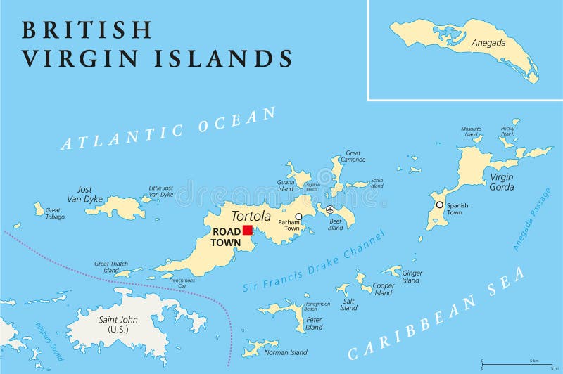
Free with trial British Virgin Islands Political Map, a british overseas territory located between the Caribbean Sea and the Atlantic Ocean and part of the Virgin islands archipelago. English labeling and scaling. Illustration. Scaling vectors British Virgin Islands Political Map. A british overseas territory located between the Caribbean Sea and the Atlantic Ocean and part of the Virgin islands. British Virgin Islands Political Map, a british overseas territory located between the Caribbean Sea and the Atlantic Ocean and part of the Virgin islands archipelago. English labeling and scaling. Illustration.
Free with trial Central Europe countries political map with national borders. Gray illustration with English labeling and scaling on white background. Scaling vectors Central Europe countries political map. With national borders. Gray illustration with English labeling and scaling on white background
Free with trial UAE United Arab Emirates political map with capital Abu Dhabi, national borders, important cities and bodies of water. English labeling and scaling. Illustration. Scaling vectors UAE United Arab Emirates Political Map. With capital Abu Dhabi, national borders, important cities and bodies of water. English labeling and scaling
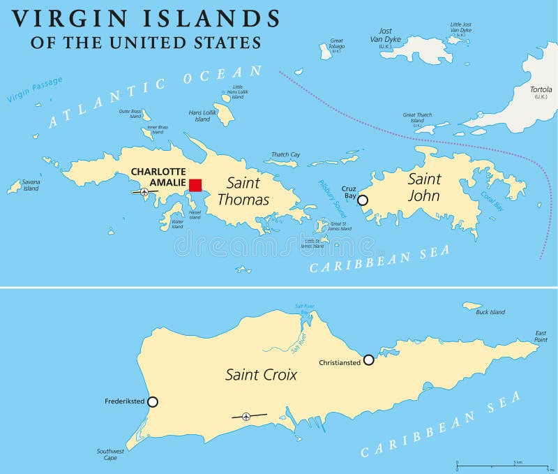
Free with trial United States Virgin Islands Political Map. A group of islands in the Caribbean that are an insular area of the United States. English labeling and scaling. Illustration. Scaling vectors United States Virgin Islands Political Map. A group of islands in the Caribbean that are an insular area of the United States. English labeling and scaling
Free with trial Honduras political map with capital Tegucigalpa, with national borders, most important cities, rivers and lakes. Illustration with English labeling and scaling. Vector. Scaling vectors Honduras Political Map. With capital Tegucigalpa, with national borders, most important cities, rivers and lakes. Illustration with English labeling and scaling
Free with trial Barbados Political Map with capital Bridgetown, with important cities, places and rivers. English labeling and scaling. Illustration. Scaling vectors Barbados Political Map. With capital Bridgetown, with important cities, places and rivers. English labeling and scaling. Illustration
Free with trial Dominican Republic Political Map with capital Santo Domingo, with national borders, important cities, rivers and lakes. English labeling and scaling. Illustration. Scaling vectors Dominican Republic Political Map. With capital Santo Domingo, with national borders, important cities, rivers and lakes. English labeling and scaling
Free with trial Mediterranean Sea region countries political map with national borders. South Europe, North Africa and Near East with national borders. English labeling and scaling. Illustration. Scaling vectors Mediterranean Sea region countries map. Mediterranean Sea region countries political map with national borders. South Europe, North Africa and Near East with. Mediterranean Sea region countries political map with national borders. South Europe, North Africa and Near East with national borders. English labeling and scaling. Illustration.
Free with trial Utility meters: electricity - gas - cold water - hot water - heating for banner, icon, web design, documents etc. Scaling vectors Icons Utility meters: electricity, gas, cold water, hot water, heating. Utility meters: electricity - gas - cold water - hot water - heating for banner, icon. Utility meters: electricity - gas - cold water - hot water - heating for banner, icon, web design, documents etc.
Free with trial Vector set of pen, pencil and ruler. Hand drawn cartoon, doodle illustration. Scaling vectors Vector set of pen, pencil and ruler. Hand drawn cartoon, doodle illustration
Free with trial Map of Italy - regions. Map of Italy - with regions and names. Scaling vectors Map of Italy - regions. Map of Italy - with regions and names
Free with trial Classic and post-classic Maya civilization in Mesoamerica. Political map with capitals, national borders, most important ancient cities, rivers and lakes. Vector illustration with English labeling and scaling. Scaling vectors Maya High Culture Area Map. Classic and post-classic Maya civilization in Mesoamerica. Political map with capitals, national borders, most important ancient. Classic and post-classic Maya civilization in Mesoamerica. Political map with capitals, national borders, most important ancient cities, rivers and lakes. Vector illustration with English labeling and scaling.
Free with trial Vector illustration of a man scaling a ladder to a cloud with money bags. Scaling vectors Scaling Ladder to the Money. Vector illustration of a man scaling a ladder to a cloud with money bags. Vector illustration of a man scaling a ladder to a cloud with money bags.
Free with trial Teeth scaling, dental plaque removal for cleaning - tooth cartoon vector flat style cute character for design. Scaling vectors Teeth scaling, dental plaque removal for cleaning. Tooth cartoon vector flat style cute character for design
Free with trial Rock climbing wall with grips, mats and ropes for bouldering activity in gym or recreation area for scaling in amusement park or kids playground. Alpinism training place. Cartoon vector illustration. Scaling vectors Rock climbing wall with grips, mats and ropes. For bouldering activity in gym or recreation area for scaling in amusement park or kids playground. Alpinism. Rock climbing wall with grips, mats and ropes for bouldering activity in gym or recreation area for scaling in amusement park or kids playground. Alpinism training place. Cartoon vector illustration
Free with trial Measuring tape ruler. Measurement tool. Builder or repair instruments. Scaling process vector illustration on white. Scaling vectors Measuring tape ruler. Measurement tool. Builder or repair instruments. Scaling process vector illustration on white
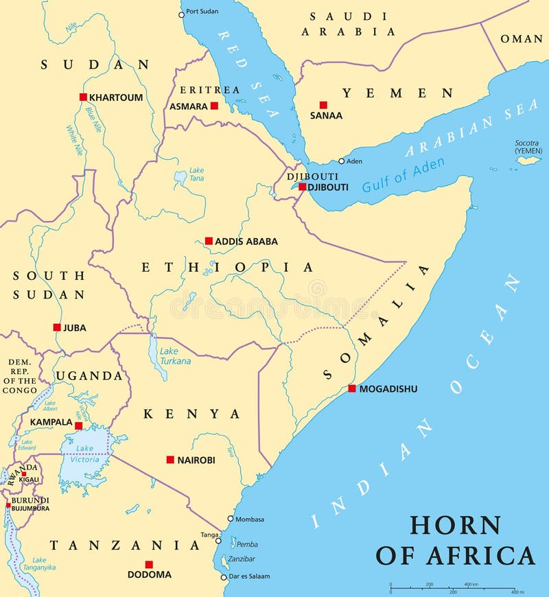
Free with trial Horn of Africa peninsula political map with capitals, national borders, important cities, rivers and lakes. In ancient times called Land of the Berbers. English labeling and scaling. Illustration. Scaling vectors Horn of Africa Political Map. Horn of Africa peninsula political map with capitals, national borders, important cities, rivers and lakes. In ancient times called. Horn of Africa peninsula political map with capitals, national borders, important cities, rivers and lakes. In ancient times called Land of the Berbers. English labeling and scaling. Illustration.
Free with trial Finland Political Map with capital Helsinki, national borders, important cities, rivers and lakes. English labeling and scaling. Illustration. Scaling vectors Finland Political Map. With capital Helsinki, national borders, important cities, rivers and lakes. English labeling and scaling. Illustration
Free with trial Papua New Guinea political map with capital Port Moresby, national borders, most important cities, rivers and lakes. Illustration with English labeling and scaling. Vector. Scaling vectors Papua New Guinea Political Map. With capital Port Moresby, national borders, most important cities, rivers and lakes. Illustration with English labeling and
Free with trial Political map of Zimbabwe with capital Harare, with national borders, most important cities, rivers and lakes. Illustration with English labeling and scaling. Scaling vectors Zimbabwe Political Map. Political map of Zimbabwe with capital Harare, with national borders, most important cities, rivers and lakes. Illustration with English. Political map of Zimbabwe with capital Harare, with national borders, most important cities, rivers and lakes. Illustration with English labeling and scaling.
Free with trial Political map of Austria with capital Vienna, with national borders, most important cities, rivers and lakes. Illustration with English labeling and scaling. Scaling vectors Austria Political Map. Political map of Austria with capital Vienna, with national borders, most important cities, rivers and lakes. Illustration with English. Political map of Austria with capital Vienna, with national borders, most important cities, rivers and lakes. Illustration with English labeling and scaling.
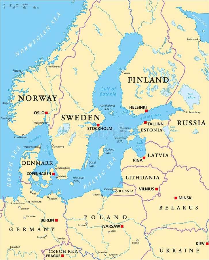
Free with trial Baltic Sea Area Political Map with capitals, national borders, important cities, rivers and lakes. English labeling and scaling. Illustration. Scaling vectors Baltic Sea Area Political Map. With capitals, national borders, important cities, rivers and lakes. English labeling and scaling. Illustration
Free with trial Political map of Uganda with capital Kampala, with national borders, most important cities, rivers and lakes. Illustration with English labeling and scaling. Scaling vectors Uganda Political Map. Political map of Uganda with capital Kampala, with national borders, most important cities, rivers and lakes. Illustration with English. Political map of Uganda with capital Kampala, with national borders, most important cities, rivers and lakes. Illustration with English labeling and scaling.
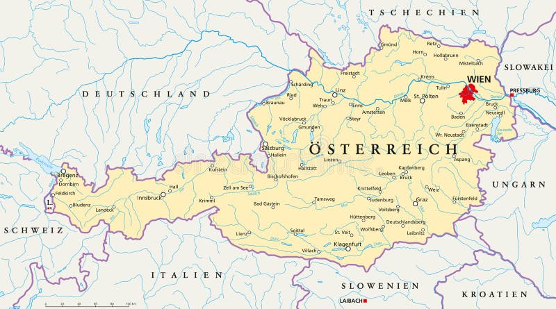
Free with trial Political map of Austria with capital Vienna, national borders, most important cities, rivers and lakes. Illustration with German labeling and scaling. Scaling vectors Austria political map German labeling. Political map of Austria with capital Vienna, national borders, most important cities, rivers and lakes. Illustration with. Political map of Austria with capital Vienna, national borders, most important cities, rivers and lakes. Illustration with German labeling and scaling.
Free with trial Guatemala political map with capital Guatemala City, national borders, most important cities, rivers and lakes. Illustration with English labeling and scaling. Vector. Scaling vectors Guatemala Political Map. With capital Guatemala City, national borders, most important cities, rivers and lakes. Illustration with English labeling and scaling
Free with trial Wooden buildings on the farm on a white background. You can easily create your own buildings by adding and scaling elements Vector without gradients. Scaling vectors Wooden farm building set. Wooden buildings on the farm on a white background. You can easily create your own buildings by adding and scaling elements Vector. Wooden buildings on the farm on a white background. You can easily create your own buildings by adding and scaling elements Vector without gradients.
Free with trial Waistline. Girl measures waist emblem. Scaling vectors Waistline. Girl measures waist emblem
Free with trial Hawaii islands political map with capital Honolulu, most important cities and volcanoes. Illustration with English labeling and scaling. Vector. Scaling vectors Hawaii Islands Political Map. With capital Honolulu, most important cities and volcanoes. Illustration with English labeling and scaling. Vector
Free with trial Rock Climbing. A pair of rock climbers scaling a wall in a frame. Scaling vectors Rock Climbing. A pair of rock climbers scaling a wall in a frame
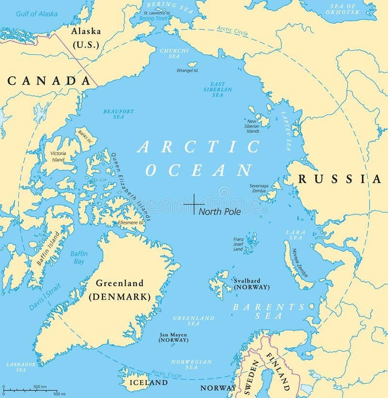
Free with trial Arctic Ocean map with North Pole and Arctic Circle. Arctic region map with countries, national borders, rivers and lakes. Map without sea ice. English labeling and scaling. Scaling vectors Arctic Ocean Map. With North Pole and Arctic Circle. Arctic region map with countries, national borders, rivers and lakes. Map without sea ice. English labeling
Free with trial US State Alaska Political Map with capital Juneau, national borders, important cities, rivers and lakes. English labeling and scaling. Illustration. Scaling vectors Alaska Political Map. US State Alaska Political Map with capital Juneau, national borders, important cities, rivers and lakes. English labeling and scaling. US State Alaska Political Map with capital Juneau, national borders, important cities, rivers and lakes. English labeling and scaling. Illustration.
Free with trial Veterinarian dentist. Veterinarian doing dental work on a someone's pet. Scaling vectors Veterinarian dentist. Veterinarian doing dental work on a someone's pet
Free with trial Iceland Political Map with capital Reykjavik, national borders, important cities, rivers, lakes and glaciers. English labeling and scaling. Illustration. Scaling vectors Iceland Political Map. With capital Reykjavik, national borders, important cities, rivers, lakes and glaciers. English labeling and scaling. Illustration
Free with trial Slovenia political map with capital Ljubljana, national borders, important cities, rivers and lakes. English labeling and scaling. Illustration. Scaling vectors Slovenia Political Map. With capital Ljubljana, national borders, important cities, rivers and lakes. English labeling and scaling. Illustration
Free with trial Political map of Ethiopia with capital Addis Ababa, national borders, most important cities, rivers and lakes. Illustration with English labeling and scaling. Scaling vectors Ethiopia Political Map. Political map of Ethiopia with capital Addis Ababa, national borders, most important cities, rivers and lakes. Illustration with English. Political map of Ethiopia with capital Addis Ababa, national borders, most important cities, rivers and lakes. Illustration with English labeling and scaling.
 Sign in