Free with trial Rosemary, fragrant, perennial herb with delicate, blue flowers from the Mediterranean region. Dark green, narrow leaves are used as seasoning, in medicine and in perfumes. See other herbs and spices in this series. Single region vectors Fresh Rosemary Herb. Rosemary, fragrant, perennial herb with delicate, blue flowers from the Mediterranean region. Dark green, narrow leaves are used as. Rosemary, fragrant, perennial herb with delicate, blue flowers from the Mediterranean region. Dark green, narrow leaves are used as seasoning, in medicine and in perfumes. See other herbs and spices in this series.
Free with trial Map Czech Republic. An illustrated map of the Czech Republic showing the single regions. Single region vectors Map Czech Republic. An illustrated map of the Czech Republic showing the single regions
Free with trial Rosemary, a most fragrant, perennial herb with delicate blue flowers from the Mediterranean region. Dark green, narrow leaves used cooking, medicine and in perfumes. See other herbs and spices in this series. Single region vectors Rosemary Herb. Rosemary, a most fragrant, perennial herb with delicate blue flowers from the Mediterranean region. Dark green, narrow leaves used cooking. Rosemary, a most fragrant, perennial herb with delicate blue flowers from the Mediterranean region. Dark green, narrow leaves used cooking, medicine and in perfumes. See other herbs and spices in this series.
Free with trial Regions of Europe, political map, with single countries. Northern, Western, Southeastern, Eastern, Central, Southern and Southwestern Europe in different colors. English labeling. Illustration. Vector. Single region vectors Regions of Europe, political map, with single countries. Northern, Western, Southeastern, Eastern, Central, Southern and Southwestern Europe in different
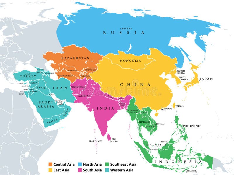
Free with trial Main regions of Asia. Political map with single countries. Colored subregions of the Asian continent. Central, East, North, South, Southeast and Western Asia. English labeled. Illustration. Vector. Single region vectors Asia, continent, main regions, political map with subregions. Main regions of Asia. Political map with single countries. Colored subregions of the Asian. Main regions of Asia. Political map with single countries. Colored subregions of the Asian continent. Central, East, North, South, Southeast and Western Asia. English labeled. Illustration. Vector.
Free with trial Africa regions political map with single countries. United Nations geoscheme. Northern, Western, Central, Eastern and Southern Africa in different colors. English labeling. Illustration. Vector. Single region vectors Africa regions map with single countries. Africa regions political map with single countries. United Nations geoscheme. Northern, Western, Central, Eastern and. Africa regions political map with single countries. United Nations geoscheme. Northern, Western, Central, Eastern and Southern Africa in different colors. English labeling. Illustration. Vector.
Free with trial Europe, map. Poster map of the Europe with country names. Print map of Europe for web and polygraphy on business, economic, political, geography themes. Vector Illustration. Single region vectors Europe, map. Poster map of the Europe with country names. Print map of Europe for web and polygraphy on business, economic, political, geography themes. Vector
Free with trial Twenty Maps regionі of Italy - alphabetical order with name. Every single map of region are listed and isolated with wordings and titles. Italian Republic. Regions. EPS10. Single region vectors Twenty Maps regionі of Italy - alphabetical order with name. Every single map of region are listed and isolated with wordings. And titles. Italian Republic
Free with trial Oceania, colored single states, political map. Geographic region, southeast of the Asia-Pacific region including Australasia, Melanesia, Micronesia and Polynesia. Illustration over white. Vector. Single region vectors Oceania, colored single states, political map. Geographic region, southeast of the Asia-Pacific region including Australasia, Melanesia, Micronesia and
Free with trial Oceania, single states, political map. Geographic region, southeast of the Asia-Pacific region including Australasia, Melanesia, Micronesia and Polynesia. English. Illustration over white. Vector. Single region vectors Oceania, single states, political map. Geographic region, southeast of the Asia-Pacific region including Australasia, Melanesia, Micronesia and Polynesia
Free with trial Benelux single states political map. Region formed by the countries Belgium, Netherlands and Luxembourg. The name Benelux comes from the first letters of the countries. Illustration over white. Vector. Single region vectors Benelux, Belgium, Netherlands and Luxembourg, single states, political map. Benelux single states political map. Region formed by the countries Belgium. Benelux single states political map. Region formed by the countries Belgium, Netherlands and Luxembourg. The name Benelux comes from the first letters of the countries. Illustration over white. Vector
Free with trial Martinique Map Flag. Map of Martinique with flag isolated on white background. Overseas department, region and single territorial collectivity of France. Vector illustration. Single region vectors Martinique Map Flag. Map of Martinique with flag isolated on white background. Overseas department, region and single territorial. Collectivity of France
Free with trial West, U. S. census region, multi colored political map. Census region 4 of the United States, consisting of 13 single states. Colored silhouettes of single states with borders and their capitals. Single region vectors West, U.S. census region, multi colored political map. Census region 4 of the United States, consisting of 13 single states. Colored silhouettes of single
Free with trial South, census region of the United States of America, gray political map of census region 3, consisting of 13 single states and the District of Columbia. Map with geographical borders and capitals. Single region vectors South, census region of the United States, gray political map. South, census region of the United States of America, gray political map of census region 3. South, census region of the United States of America, gray political map of census region 3, consisting of 13 single states and the District of Columbia. Map with geographical borders and capitals.
Free with trial Europe regions, political map, with single countries. Northern, Western, Southeastern, Eastern, Central, Southern and Southwestern Europe in different colors. English labeling. Illustration. Vector. Single region vectors Europe regions, political map, with single countries. Northern, Western, Southeastern, Eastern, Central, Southern and Southwestern Europe in different colors
Free with trial East Asia, single states, political map. All countries in different colors, with national borders, labeled with English country names. Eastern subregion of the Asian continent. Illustration. Vector. Single region vectors East Asia, single states, political map. All countries in different colors, with national borders, labeled with English country names. Eastern subregion of the
Free with trial Northeast, U. S. census region, multi colored political map. Census region 1 of the United States, consisting of 9 single states. Colored silhouettes of single states with borders and their capitals. Single region vectors Northeast, U.S. census region, multi colored political map. Census region 1 of the United States, consisting of 9 single states. Colored silhouettes of single
Free with trial Midwest, census region of the United States of America, gray political map of census region 2, consisting of 12 single states. Map with geographical borders and capitals. Isolated illustration. Single region vectors Midwest, census region of the United States, gray political map. Midwest, census region of the United States of America, gray political map of census region 2. Midwest, census region of the United States of America, gray political map of census region 2, consisting of 12 single states. Map with geographical borders and capitals. Isolated illustration.
Free with trial Northeast, census region of the United States of America, gray political map of census region 1, consisting of 9 single states. Map with geographical borders and capitals. Isolated illustration. Single region vectors Northeast, census region of the United States, gray political map. Northeast, census region of the United States of America, gray political map of census region. Northeast, census region of the United States of America, gray political map of census region 1, consisting of 9 single states. Map with geographical borders and capitals. Isolated illustration.
Free with trial West, census region of the United States of America, gray political map of census region 4, consisting of 13 single states. Map with geographical borders and capitals. Isolated illustration. Single region vectors West, census region of the United States, gray political map. West, census region of the United States of America, gray political map of census region 4. West, census region of the United States of America, gray political map of census region 4, consisting of 13 single states. Map with geographical borders and capitals. Isolated illustration.
Free with trial Vector map for Black Sea region with country boundaries of Russia, Turkey, Ukraine, Romania, Bulgaria, Moldova, Georgia and other relevant countries in yellow. Single region vectors Black Sea map with surrounding countries and names in single colour. Vector map for Black Sea region with country boundaries of Russia, Turkey, Ukraine, Romania. Vector map for Black Sea region with country boundaries of Russia, Turkey, Ukraine, Romania, Bulgaria, Moldova, Georgia and other relevant countries in yellow
Free with trial Single continuous line drawing of beauty fresh fuchsia flower for home decor wall art poster print. Decorative shrubs plant for floral invitation card. Modern one line draw design vector illustration. Single region vectors Single continuous line drawing of beauty fresh fuchsia flower for home decor wall art poster print. Decorative shrubs plant for. Floral invitation card. Modern. Single continuous line drawing of beauty fresh fuchsia flower for home decor wall art poster print. Decorative shrubs plant for floral invitation card. Modern one line draw design vector illustration
Free with trial White Hong Kong map with single border line on dark background vector illustration. Single region vectors White Hong Kong map with single border line on dark background vector illustration. White Hong Kong map with single border line on dark background vector
Free with trial A blue German map with single border line and shading on dark background. Vector illustration. Single region vectors A blue German map with single border line and shading on dark background. Vector illustration
Free with trial Kazakhstan vector map with single land area using green color on dark background illustration. Kazakhstan vector map with single land area using green color on. Single region vectors Kazakhstan vector map with single land area using green color on dark background illustration. Kazakhstan vector map with single land area using green color on
Free with trial Brush style color flag of Texas, blue containing a single centered white star. The remaining field is divided horizontally into a white and red bar. with text Texas. Single region vectors Brush style color flag of Texas, blue containing a single centered white star. The remaining field is divided horizontally. Brush style color flag of Texas. Brush style color flag of Texas, blue containing a single centered white star. The remaining field is divided horizontally into a white and red bar. with text Texas.
Free with trial French Guiana Map Flag. Map of Guyane with French flag isolated on white background. Overseas department, region and single territorial collectivity of France. Vector illustration. Single region vectors French Guiana Map Flag. Map of Guyane with French flag isolated on white background. Overseas department, region and single territ. Orial collectivity of France
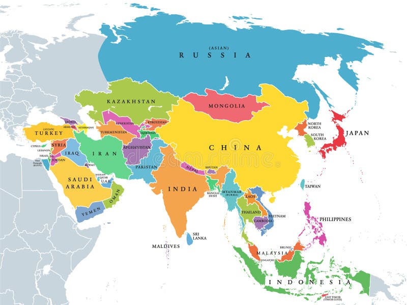
Free with trial Continent Asia, political map with colored single states and countries. With the Asian part of Russia and Turkey and Sinai Peninsula as African part. English labeling. Illustration over white. Vector. Single region vectors Continent Asia, political map with colored single states and countries. With the Asian part of Russia and Turkey and Sinai Peninsula as African part. English
Free with trial Northern Africa, subregion, political map with single countries and international borders. Group of Mediterranean countries on the African continent geoscheme. Illustration on white background. Vector. Single region vectors Northern Africa, subregion, political map with single countries. And international borders. Group of Mediterranean countries on the African continent geoscheme. Northern Africa, subregion, political map with single countries and international borders. Group of Mediterranean countries on the African continent geoscheme. Illustration on white background. Vector
Free with trial North Africa, political map with multi colored silhouettes of single countries. Sometimes called Northern Africa, a region encompassing the northern portion of the African continent. Illustration. Single region vectors North Africa, political map with multi colored country silhouettes. North Africa, political map with multi colored silhouettes of single countries. Sometimes. North Africa, political map with multi colored silhouettes of single countries. Sometimes called Northern Africa, a region encompassing the northern portion of the African continent. Illustration.
Free with trial Vector World map with country shapes in single color for one of the popular coordinate systems, which is Equidistant Cylindrical or Gall Peters. Single region vectors World map with country boundary in Equidistant Cylindrical (Gall Peters) Projection. Vector World map with country shapes in single color for one of the popular. Vector World map with country shapes in single color for one of the popular coordinate systems, which is Equidistant Cylindrical or Gall Peters
Free with trial Vector World map with country shapes in single color for one of the popular coordinate systems, which is WGS 1984 Adams Square II. Single region vectors World Map with country boundary in WGS 1984 Adams Square II coordinate system. Vector World map with country shapes in single color for one of the popular. Vector World map with country shapes in single color for one of the popular coordinate systems, which is WGS 1984 Adams Square II
Free with trial Vector World map with single color and global boundary for one of the popular coordinate systems, which is World Equidistant Cylindrical or Gall Peters. Single region vectors World map with outline in World Equidistant Cylindrical or Gall Peters coordinate system. Vector World map with single color and global boundary for one of the. Vector World map with single color and global boundary for one of the popular coordinate systems, which is World Equidistant Cylindrical or Gall Peters
Free with trial Vector World map with single color and global boundary for one of the popular coordinate systems, which is World Patterson. Single region vectors World map with outline in World Patterson coordinate system. Vector World map with single color and global boundary for one of the popular coordinate systems. Vector World map with single color and global boundary for one of the popular coordinate systems, which is World Patterson
Free with trial Vector World map with single color and global boundary for one of the popular coordinate systems, which is World Fuller. Single region vectors World map with outline in World Fuller coordinate system. Vector World map with single color and global boundary for one of the popular coordinate systems, which. Vector World map with single color and global boundary for one of the popular coordinate systems, which is World Fuller
Free with trial Vector World map with single color and global boundary for one of the popular coordinate systems, which is World North Pole Azimuthal Equidistant. Single region vectors World map with outline in North Pole Azimuthal Equidistant coordinate system. Vector World map with single color and global boundary for one of the popular. Vector World map with single color and global boundary for one of the popular coordinate systems, which is World North Pole Azimuthal Equidistant
Free with trial Vector World map with country shapes in single color for one of the popular coordinate systems, which is World Mollweide. Single region vectors World Map with country boundary in World Mollweide coordinate system. Vector World map with country shapes in single color for one of the popular coordinate. Vector World map with country shapes in single color for one of the popular coordinate systems, which is World Mollweide
Free with trial Continuous one line drawing Enterprise city skyline, Alabama. Beautiful landmark. World landscape tourism travel wall decor poster print art. Stylish single line draw design vector illustration. Single region vectors Continuous one line drawing Enterprise city skyline, Alabama. Beautiful landmark. World landscape travel wall decor. Continuous one line drawing Enterprise city. Continuous one line drawing Enterprise city skyline, Alabama. Beautiful landmark. World landscape tourism travel wall decor poster print art. Stylish single line draw design vector illustration
Free with trial Roosters. Illustration of Polish traditional papercut from Lowicz region. Single region vectors Roosters. Illustration of Polish traditional papercut from Lowicz region
Free with trial Peacocks. Illustration of Polish traditional papercut from Lowicz region. Single region vectors Peacocks. Illustration of Polish traditional papercut from Lowicz region
Free with trial Bunch of flowers. Illustration of Polish traditional papercut from Lowicz region. Single region vectors Bunch of flowers. Illustration of Polish traditional papercut from Lowicz region
Free with trial Africa regions political map. United Nations geoscheme with single countries. Northern, Western, Central, Eastern and Southern Africa in different colors. English labeling. Illustration. Vector. Single region vectors Africa regions political map. United Nations geoscheme with single countries. Northern, Western, Central, Eastern and Southern Africa in different colors
Free with trial Tides. Gravitational pull between moon and earth, Gravitational pull between sun and earth. Health care education infographic. Vector design. Single region vectors Tides. Gravitational pull between moon and earth, Gravitational pull between sun and earth. Health care education infographic. Vector design
Free with trial Regions of Africa. Political map. United Nations geoscheme with single countries. North, West, Central, East and Southern Africa in different colors. English labeling. Illustration over white. Vector. Single region vectors Regions of Africa political map. Regions of Africa. Political map. United Nations geoscheme with single countries. North, West, Central, East and Southern Africa. Regions of Africa. Political map. United Nations geoscheme with single countries. North, West, Central, East and Southern Africa in different colors. English labeling. Illustration over white. Vector.
Free with trial Stamp with map of Spain. Grunge stamp with map of Spain - vector illustration. Single region vectors Stamp with map of Spain. Grunge stamp with map of Spain - vector illustration
Free with trial Three young Families and Houses. Vector Illustration. Single region vectors Three young Families and Houses. Vector Illustration
Free with trial Europe, map. Poster map of the Europe with country names. Print map of Europe for web and polygraphy on business, economic, political, geography themes. Vector Illustration. Single region vectors Europe, map. Poster map of the Europe with country names. Print map of Europe for web and polygraphy on business, economic, political, geography themes. Vector
Free with trial Continuous line drawing of Arkansas. Continuous line drawing - isolated layered easy-edit vector illustration in EPS10 format. Single region vectors Continuous line drawing of Arkansas. Continuous line drawing - isolated layered easy-edit vector illustration in EPS10 format
Free with trial Europe, map. Poster map of the Europe with country names. Print map of Europe for web and polygraphy on business, economic, political, geography themes. Vector Illustration. Single region vectors Europe, map. Poster map of the Europe with country names. Print map of Europe for web and polygraphy on business, economic, political, geography themes. Vector
Free with trial Mezquita Cathedral The Great Mosque. In the city of Cordoba, Spain, Andalusia region. Single region vectors Mezquita Cathedral The Great Mosque. In the city of Cordoba, Spain, Andalusia region
Free with trial Continuous line drawing of California home sign. Continuous line drawing - isolated layered easy-edit vector illustration in EPS10 format. Single region vectors Continuous line drawing of California home sign. Continuous line drawing - isolated layered easy-edit vector illustration in EPS10 format
Free with trial Africa political map with country names. Details of colorful African maps with all country names isolated on white background. Vector stock. Single region vectors Africa political map with country names. Details of colorful African maps with all country names isolated on white background. Vector stock
Free with trial Swedish Dala Horses are traditional wooden horse figurines that originated from the province of Dalarna in Sweden. These iconic horses are typically carved from pine wood and feature a distinctive shape with a long, curved neck and a raised tail. They are painted in bright, bold colors such as red, blue, and white, with intricate designs and patterns that are often unique to the individual artisan who crafted them..... The Dala Horse has become a beloved symbol of Swedish culture and heritage, representing the rural way of life and the traditional crafts that have been passed down through generations. These decorative horses were originally created as toys for children, but have since become popular souvenirs and collectibles that are cherished around the world..... The art of making Dala Horses is a cottage industry that continues to thrive in the Dalarna region, with many skilled artisans and small family businesses producing these beautiful wooden figurines by hand. Each horse is carefully crafted and painted, making each one a unique work of art that reflects the skill and creativity of the maker..... Whether displayed as a decorative ornament or played with as a toy, Swedish Dala Horses are a timeless symbol of tradition, craftsmanship, and the beauty of Scandinavian design. Single region vectors Swedish Dala horses as single colored vector icons. Swedish Dala Horses are traditional wooden horse figurines that originated from the province of Dalarna in. Swedish Dala Horses are traditional wooden horse figurines that originated from the province of Dalarna in Sweden. These iconic horses are typically carved from pine wood and feature a distinctive shape with a long, curved neck and a raised tail. They are painted in bright, bold colors such as red, blue, and white, with intricate designs and patterns that are often unique to the individual artisan who crafted them.....The Dala Horse has become a beloved symbol of Swedish culture and heritage, representing the rural way of life and the traditional crafts that have been passed down through generations. These decorative horses were originally created as toys for children, but have since become popular souvenirs and collectibles that are cherished around the world.....The art of making Dala Horses is a cottage industry that continues to thrive in the Dalarna region, with many skilled artisans and small family businesses producing these beautiful wooden figurines by hand. Each horse is carefully crafted and painted, making each one a unique work of art that reflects the skill and creativity of the maker.....Whether displayed as a decorative ornament or played with as a toy, Swedish Dala Horses are a timeless symbol of tradition, craftsmanship, and the beauty of Scandinavian design.
Free with trial Continuous line drawing of Florida home sign. Continuous line drawing - isolated layered easy-edit vector illustration in EPS10 format. Single region vectors Continuous line drawing of Florida home sign. Continuous line drawing - isolated layered easy-edit vector illustration in EPS10 format
Free with trial Continuous line drawing of Delaware home sign. Continuous line drawing - isolated layered easy-edit illustration in EPS10 format. Single region vectors Continuous line drawing of Delaware home sign. Continuous line drawing - isolated layered easy-edit illustration in EPS10 format
Free with trial Location point icon,Vector and Illustration. Single region vectors Location point icon,Vector and Illustration.
Free with trial Map of turkey. High detailed vector map - turkey. map shape/contour/outline/border with state isolate on white background. Single region vectors Map of turkey. High detailed vector map - turkey. Map shape/contour/outline/border with state isolate on white background
Free with trial Shape of Colombia map made of scattered coffee beans, country name below. Single region vectors Shape of Colombia map made of scattered coffee beans, country name below.
Free with trial Shape of Ethiopia map made of scattered coffee beans, country name below. Single region vectors Shape of Ethiopia map made of scattered coffee beans, country name below.
Free with trial Shape of Nicaragua map made of scattered coffee beans, country name below. Single region vectors Shape of Nicaragua map made of scattered coffee beans, country name below.
Free with trial Vector illustration of New Zealand map with capital city Wellington. Vector map. Single region vectors Vector illustration of New Zealand map with capital city Wellington. Vector map
Free with trial Shape of India map made of scattered coffee beans, country name below. Single region vectors Shape of India map made of scattered coffee beans, country name below.
Free with trial Inscription you super star. The inscription you're a super star different fonts on the background with stars. Single region vectors Inscription you super star. The inscription you're a super star different fonts on the background with stars
Free with trial Location point icon,Vector and Illustration. Single region vectors Location point icon,Vector and Illustration.
Free with trial Cityscape and people community - Vector flat minimal icon. Flat and isolated vector eps illustration icon with minimal design and long shadow. Single region vectors Cityscape and people community - Vector flat minimal icon. Flat and isolated vector eps illustration icon with minimal design and long shadow
Free with trial During the process of splicing, introns are removed from the pre-mRNA by the spliceosome and exons are spliced back together. Single region vectors Formation of mature mRNA through splicing scientific vector illustration infographic. During the process of splicing, introns are removed from the pre-mRNA by. During the process of splicing, introns are removed from the pre-mRNA by the spliceosome and exons are spliced back together
Free with trial Flag of Corsica - vector illustration. Single region vectors Flag of Corsica. Vector illustration
Free with trial Map of Bermuda - vector illustration. Single region vectors Map of Bermuda. Vector illustration
Free with trial Large collection of Texas flags of various shapes and effects. Big set of vector flag. Single region vectors Large collection of Texas flags of various shapes and effects. Big set of vector flag
Free with trial Russia flag world map in pin with name of country. On gray background. Single region vectors Russia flag world map in pin with name of country. On gray background
Free with trial Romania flag world map in pin with name of country. On gray background. Single region vectors Romania flag world map in pin with name of country. On gray background
Free with trial The Four Corners, a region of the Southwestern United States, political map. The only place in the USA where four states meet at a single point - Arizona, Colorado, New Mexico, and Utah. Vector. Single region vectors Four Corners, a region of the United States, political map. The Four Corners, a region of the Southwestern United States, political map. The only place in the. The Four Corners, a region of the Southwestern United States, political map. The only place in the USA where four states meet at a single point - Arizona, Colorado, New Mexico, and Utah. Vector
Free with trial Dangqiongcuo is one of the hidden sacred lakes on the Great Northern Route in Ali, Tibet. Located in the southern part of Nyima County, Nagqu City, Xizang Autonomous Region, it has an elevation of 4,475 meters and covers an area of 54. 5 square kilometers. This lake exhibits different colors under different lighting conditions, changing from light green to dark green to black green within a single day, resembling an emerald inlaid on the plateau. Despite its high altitude, it remains a popular tourist destination and a stunning scenery for many people. Single region vectors Dangqiong Lake in the Ali region of Xizang. Dangqiongcuo is one of the hidden sacred lakes on the Great Northern Route in Ali, Tibet. Located in the southern. Dangqiongcuo is one of the hidden sacred lakes on the Great Northern Route in Ali, Tibet. Located in the southern part of Nyima County, Nagqu City, Xizang Autonomous Region, it has an elevation of 4,475 meters and covers an area of 54.5 square kilometers. This lake exhibits different colors under different lighting conditions, changing from light green to dark green to black green within a single day, resembling an emerald inlaid on the plateau. Despite its high altitude, it remains a popular tourist destination and a stunning scenery for many people.
Free with trial Dangqiongcuo is one of the hidden sacred lakes on the Great Northern Route in Ali, Tibet. Located in the southern part of Nyima County, Nagqu City, Xizang Autonomous Region, it has an elevation of 4,475 meters and covers an area of 54. 5 square kilometers. This lake exhibits different colors under different lighting conditions, changing from light green to dark green to black green within a single day, resembling an emerald inlaid on the plateau. Despite its high altitude, it remains a popular tourist destination and a stunning scenery for many people. Single region vectors Dangqiong Lake in the Ali region of Tibet. Dangqiongcuo is one of the hidden sacred lakes on the Great Northern Route in Ali, Tibet. Located in the southern part. Dangqiongcuo is one of the hidden sacred lakes on the Great Northern Route in Ali, Tibet. Located in the southern part of Nyima County, Nagqu City, Xizang Autonomous Region, it has an elevation of 4,475 meters and covers an area of 54.5 square kilometers. This lake exhibits different colors under different lighting conditions, changing from light green to dark green to black green within a single day, resembling an emerald inlaid on the plateau. Despite its high altitude, it remains a popular tourist destination and a stunning scenery for many people.
Free with trial Dangqiongcuo is one of the hidden sacred lakes on the Great Northern Route in Ali, Tibet. Located in the southern part of Nyima County, Nagqu City, Xizang Autonomous Region, it has an elevation of 4,475 meters and covers an area of 54. 5 square kilometers. This lake exhibits different colors under different lighting conditions, changing from light green to dark green to black green within a single day, resembling an emerald inlaid on the plateau. Despite its high altitude, it remains a popular tourist destination and a stunning scenery for many people. Single region vectors Dangqiong Lake in the Ali region of TIbet. Dangqiongcuo is one of the hidden sacred lakes on the Great Northern Route in Ali, Tibet. Located in the southern part. Dangqiongcuo is one of the hidden sacred lakes on the Great Northern Route in Ali, Tibet. Located in the southern part of Nyima County, Nagqu City, Xizang Autonomous Region, it has an elevation of 4,475 meters and covers an area of 54.5 square kilometers. This lake exhibits different colors under different lighting conditions, changing from light green to dark green to black green within a single day, resembling an emerald inlaid on the plateau. Despite its high altitude, it remains a popular tourist destination and a stunning scenery for many people.
Free with trial Antibody Fragment scFv, labeled diagram, educational immunology poster design, cloning of single-chain variable fragment, IgG comparison, Fab region, VH, VL, CH1, CL, linker, recombinant protein. Single region vectors Antibody Fragment scFv, labeled diagram, educational immunology poster design, cloning of single-chain variable fragment, IgG. Comparison, Fab region, VH, VL. Antibody Fragment scFv, labeled diagram, educational immunology poster design, cloning of single-chain variable fragment, IgG comparison, Fab region, VH, VL, CH1, CL, linker, recombinant protein
Free with trial This graphic illustration displays a flat blue silhouette of a geographic region against a clean white background. A prominent white star icon is positioned within the interior of the shape to indicate a specific point of interest or central hub. The design is minimalist and professional, utilizing a high-contrast color palette suitable for educational or informational materials. Single region vectors A blue silhouette map of a region featuring a single white star marker. This graphic illustration displays a flat blue silhouette of a geographic region against. This graphic illustration displays a flat blue silhouette of a geographic region against a clean white background. A prominent white star icon is positioned within the interior of the shape to indicate a specific point of interest or central hub. The design is minimalist and professional, utilizing a high-contrast color palette suitable for educational or informational materials
Free with trial Six Maps of regions of Turkmenistan - alphabetical order with name. Every single map of Region are listed and isolated with wordings and titles. Turkmenistan. EPS 10. Single region vectors Six Maps of regions of Turkmenistan - alphabetical order with name. Every single map of Region are listed and isolated. With wordings and titles. Turkmenistan
Free with trial South, U. S. census region, colored political map. Census region 3 of United States, consisting of 16 single states and District of Columbia. Colored silhouettes of States with borders and capitals. Single region vectors South, U.S. census region, multi colored political map. South, U.S. census region, colored political map. Census region 3 of United States, consisting of 16. South, U.S. census region, colored political map. Census region 3 of United States, consisting of 16 single states and District of Columbia. Colored silhouettes of States with borders and capitals.
 Sign in