Free with trial Political map of Africa. Agaist white background. Every state is selectable separate. Sudan vectors Political map of Africa. Agaist white background. Every state is selectable separate
Free with trial Africa Map. A simple vector map of Africa. Sudan vectors Africa Map. A simple vector map of Africa
Free with trial Isolated raster version of vector set of world flags 4 (contain the Clipping Path of all objects) There is in addition a vector format (EPS 8). Sudan vectors Set of world flags 4. Isolated raster version of vector set of world flags 4 (contain the Clipping Path of all objects) There is in addition a vector format (EPS. Isolated raster version of vector set of world flags 4 (contain the Clipping Path of all objects) There is in addition a vector format (EPS 8)
Free with trial Sudan political map with new borders. Vector illustration of actual political situation in Sudan, Africa, 2011. Sudan vectors Sudan political map. With new borders. Vector illustration of actual political situation in Sudan, Africa, 2011
Free with trial Vector set of Flags of world sovereign states & EU (September 2011). New flags of Libya, South Sudan, Myanmar, Malawi. Sudan vectors Flags of Sovereign States & EU. Vector set of Flags of world sovereign states & EU (September 2011). New flags of Libya, South Sudan, Myanmar, Malawi. Vector set of Flags of world sovereign states & EU (September 2011). New flags of Libya, South Sudan, Myanmar, Malawi.
Free with trial Gold world global sphere with accurate coordinate grid wire framework. PNG transparent background. Sudan vectors Golden Earth planet 3D Globe isolated. Gold world global sphere with accurate coordinate grid wire framework. PNG transparent background. Gold world global sphere with accurate coordinate grid wire framework. PNG transparent background.
Free with trial A map of the African continent with each country on the continent colored in bright colors. Names of the countries and their capital are shown on a map too. Continent isolated on a white background. Sudan vectors Map of Africa. A map of the African continent with each country on the continent colored in bright colors. Names of the countries and their capital are shown on. A map of the African continent with each country on the continent colored in bright colors. Names of the countries and their capital are shown on a map too. Continent isolated on a white background.
Free with trial Africa blind map. Blind map of Africa with country borders. Names of the countries and their capital are in an additional format (. AI) in the latent layer. Sudan vectors Africa blind map. Blind map of Africa with country borders. Names of the countries and their capital are in an additional format (.AI) in the latent layer
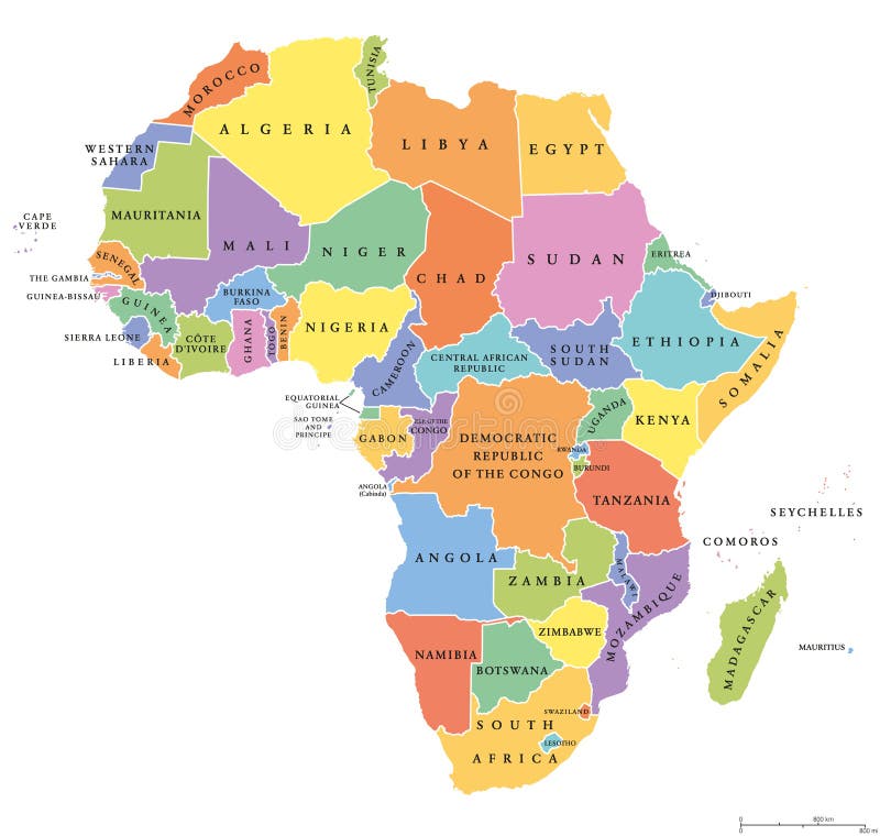
Free with trial Africa single states political map. Each country with its own color area. With national borders on white background. Continent including Madagascar and island nations. English labeling. Sudan vectors Africa single states political map. Each country with its own color area. With national borders on white background. Continent including Madagascar and island
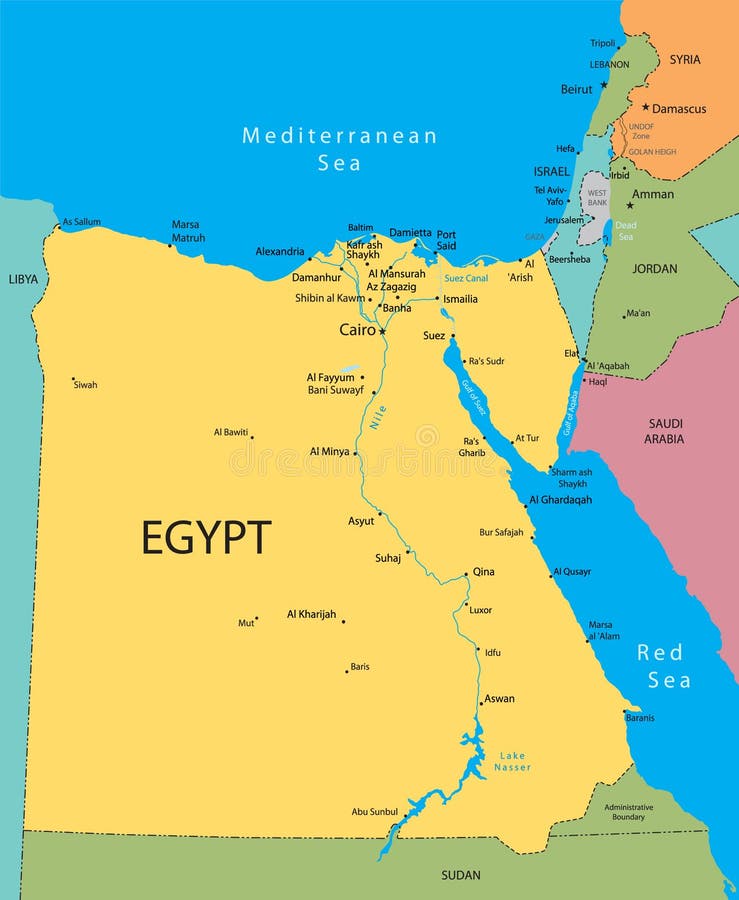
Free with trial Map of Egypt with national borders, cities rivers and lakes. Sudan vectors Map of Egypt. With national borders, cities rivers and lakes
Free with trial Vector map of Africa with present political borders. Sudan vectors Africa vector map. Vector map of Africa with present political borders. Vector map of Africa with present political borders.
Free with trial Middle East map with various countries. Sudan vectors Middle East map . Middle East map with various countries. Middle East map with various countries.
Free with trial Map of Africa with national borders and country names. Pseudo-3d illustration. Sudan vectors 3d map of Africa. Map of Africa with national borders and country names. Pseudo-3d illustration. Map of Africa with national borders and country names. Pseudo-3d illustration.
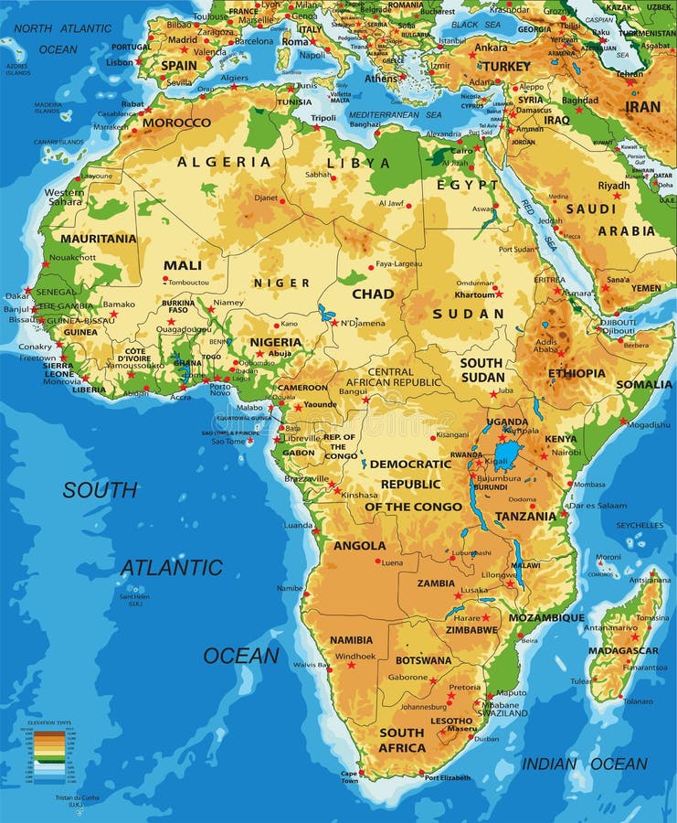
Free with trial Highly detailed physical map of Africa, in vector format, with all the relief forms, countries and big cities. Sudan vectors Africa-physical map. Highly detailed physical map of Africa, in vector format, with all the relief forms, countries and big cities. Highly detailed physical map of Africa, in vector format, with all the relief forms, countries and big cities.
Free with trial Africa Map. A full color map of africa with country names called out. Sudan vectors Africa Map. A full color map of africa with country names called out
Free with trial City skyline The Arabian Peninsula and Africa, near east. Sudan vectors City skyline The Arabian Peninsula and Africa. Near east
Free with trial Highly detailed physical map of Middle East, in vector format, with all the relief forms. Sudan vectors Middle East-physical map. Highly detailed physical map of Middle East, in vector format, with all the relief forms. Highly detailed physical map of Middle East, in vector format, with all the relief forms.
Free with trial Egypt vector map. Egypt, Israel and Jordan country vector map. Sudan vectors Egypt vector map. Egypt, Israel and Jordan country vector map
Free with trial Egypt. Abstract vector color map of Egypt country. Sudan vectors Egypt. Abstract vector color map of Egypt country
Free with trial Kenya. Abstract vector color map of Kenya country. Sudan vectors Kenya. Abstract vector color map of Kenya country
Free with trial Uganda. Abstract vector color map of Uganda country. Sudan vectors Uganda. Abstract vector color map of Uganda country
Free with trial Ethiopia. Abstract vector color map of Ethiopia country. Sudan vectors Ethiopia. Abstract vector color map of Ethiopia country
Free with trial Raster version of vector set world flag icons 4 here is in addition a vector format (EPS 8). Sudan vectors World flag icons 4. Raster version of vector set world flag icons 4 here is in addition a vector format (EPS 8. Raster version of vector set world flag icons 4 here is in addition a vector format (EPS 8)
Free with trial Vector illustration for the continent of Africa. Over 50 countries including several small islands, rivers and lakes not visible unless zoomed in. Very editable if needed. Sudan vectors Africa Continent Flag Map. Vector illustration for the continent of Africa. Over 50 countries including several small islands, rivers and lakes not visible. Vector illustration for the continent of Africa. Over 50 countries including several small islands, rivers and lakes not visible unless zoomed in. Very editable if needed.
Free with trial Vector illustration of world flags. Africa. Sudan vectors World flags. Africa. Vector illustration of world flags. Africa. Vector illustration of world flags. Africa.
Free with trial Flags globe. Africa. Vector illustration. Sudan vectors Flags globe. Africa. Vector illustration
Free with trial Vector illustration of world flags. Africa. Sudan vectors World flags. Africa. Vector illustration of world flags. Africa. Vector illustration of world flags. Africa.
Free with trial Africa flags and map. Vector illustration. Sudan vectors Africa flags and map. Vector illustration
Free with trial Vector political map of Africa with all country flags. Vector illustration political map of Africa with all country flags. Sudan vectors Vector political map of Africa with all country flags. Vector illustration political map of Africa with all country flags
Free with trial Detailed African flags and map. Manually traced from public domain map. Available in EPS file. Sudan vectors Detailed African flags and map. Manually traced from public domain map. Available in EPS file
Free with trial Big Wavy flags set - Africa & Middle East. 36 Vector flags. Sudan vectors Wavy flags set - Africa & Middle East. Big Wavy flags set - Africa & Middle East. 36 Vector flags. Big Wavy flags set - Africa & Middle East. 36 Vector flags.
Free with trial Vector map of Africa continent colored by regions. All flags of African countries arranged in alphabetical order. And singled out by regions. Sudan vectors Vector map of Africa continent colored by regions. All flags of African countries arranged in alphabetical order. And singled out by regions
Free with trial African countries flags. Frame made of African countries flags vector illustration. Sudan vectors African countries flags. Frame made of African countries flags vector illustration
Free with trial South Sudan map. Administrative division of the Republic of South Sudan. Sudan vectors South Sudan map. Administrative division of the Republic of South Sudan
Free with trial Sudan country flat cartoon style historic sight showplace web site vector illustration. World travel sightseeing Africa African collection. Tomb of the Mahdi Pyramids of Meroe University of Khartoum. Sudan vectors Sudan country design template Flat cartoon style w. Sudan country flat cartoon style historic sight showplace web site vector illustration. World travel. Sudan country flat cartoon style historic sight showplace web site vector illustration. World travel sightseeing Africa African collection. Tomb of the Mahdi Pyramids of Meroe University of Khartoum.
Free with trial Sudan. Abstract vector color map of Sudan country. Sudan vectors Sudan. Abstract vector color map of Sudan country
Free with trial Sudan flag. Waving flag of Sudan isolated on white. Sudan vectors Sudan flag. Waving flag of Sudan isolated on white
Free with trial Flag of Sudan, national country symbol illustration Vector illustration available for download. Click here for more vectors. Sudan vectors Flag of Sudan. National country symbol illustration Vector illustration available for download. Click here for more vectors
Free with trial World flags of Spain, Sri Lanka, Sudan, Suriname, Svalbard, Swaziland, Sweden and Swiss Confederation, with capitals, geographic coordinates and coat of arms, vector art illustration. Sudan vectors World flags and capitals set 23. World flags of Spain, Sri Lanka, Sudan, Suriname, Svalbard, Swaziland, Sweden and Swiss Confederation, with capitals, geographic. World flags of Spain, Sri Lanka, Sudan, Suriname, Svalbard, Swaziland, Sweden and Swiss Confederation, with capitals, geographic coordinates and coat of arms, vector art illustration
Free with trial World flags of Singapore, Slovakia, Slovenia, Solomon Islands, Somalia, South Africa, South Georgia and the South Sandwich Islands and South Sudan, with capitals, geographic coordinates and coat of arms, vector art illustration. Sudan vectors World flags and capitals set 22. World flags of Singapore, Slovakia, Slovenia, Solomon Islands, Somalia, South Africa, South Georgia and the South Sandwich. World flags of Singapore, Slovakia, Slovenia, Solomon Islands, Somalia, South Africa, South Georgia and the South Sandwich Islands and South Sudan, with capitals, geographic coordinates and coat of arms, vector art illustration
Free with trial Political map of Africa in vector. Sudan vectors Africa political map. Political map of Africa in vector. Political map of Africa in vector.
Free with trial Africa vintage detailed map print poster design. Vector illustration. Sudan vectors Africa vintage detailed map print poster design. Vector illustration.
Free with trial Isolated rustic globe Earth accurate geographic coordinates (latitude and longitude grid) wire framework. Old rusty ruined, vintage aging style. PNG with transparent background. Sudan vectors Rust Earth planet 3D Globe. Isolated rustic globe Earth accurate geographic coordinates (latitude and longitude grid) wire framework. Old rusty ruined, vintage. Isolated rustic globe Earth accurate geographic coordinates (latitude and longitude grid) wire framework. Old rusty ruined, vintage aging style. PNG with transparent background.
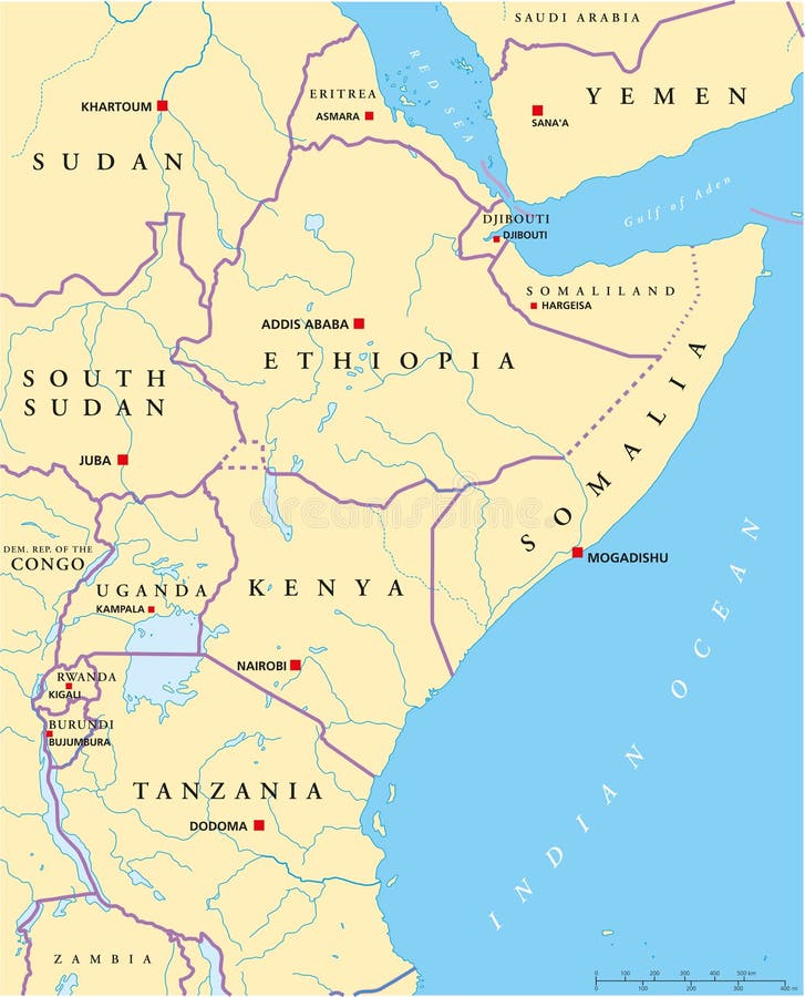
Free with trial Political map of East Africa with capitals, national borders, rivers and lakes. With english labeling and scale. Sudan vectors East Africa Political Map. Political map of East Africa with capitals, national borders, rivers and lakes. With english labeling and scale. Political map of East Africa with capitals, national borders, rivers and lakes. With english labeling and scale.
Free with trial Africa Map. A basic map of africa with water in blue and land in green. Sudan vectors Africa Map. A basic map of africa with water in blue and land in green
Free with trial Africa globe map, with the country in different colors. Sudan vectors Africa globe map. With the country in different colors
Free with trial Africa Political Map. Illustration of Africa Political Map 3D. Sudan vectors Africa Political Map. Illustration of Africa Political Map 3D
Free with trial Ethiopia map. Highly detailed vector map of Ethiopia with administrative regions,main cities and roads. Sudan vectors Ethiopia map. Highly detailed vector map of Ethiopia with administrative regions,main cities and roads
Free with trial Highly detailed vector map of Saudi Arabia with administrative regions, main cities and roads. Sudan vectors Saudi Arabia map. Highly detailed vector map of Saudi Arabia with administrative regions, main cities and roads. Highly detailed vector map of Saudi Arabia with administrative regions, main cities and roads.
Free with trial Vector silhouettes of African countries. Sudan vectors Africa. Vector silhouettes of African countries. Vector silhouettes of African countries.
Free with trial Stainless steel iron global world. Accurate geographic grid wire framework. Fine brushed metallic texture. PNG with transparent background. Sudan vectors Silver Earth planet 3D globe isolated. Stainless steel iron global world. Accurate geographic grid wire framework. Fine brushed metallic texture. PNG with. Stainless steel iron global world. Accurate geographic grid wire framework. Fine brushed metallic texture. PNG with transparent background.
Free with trial Arab World political map, also called Arab nation, consists of twenty-two arabic-speaking countries of the Arab League. All nations in green color, plus Western Sahara and Palestine. English labeling. Sudan vectors Arab World political map. Also called Arab nation, consists of twenty-two arabic-speaking countries of the Arab League. All nations in green color, plus. Arab World political map, also called Arab nation, consists of twenty-two arabic-speaking countries of the Arab League. All nations in green color, plus Western Sahara and Palestine. English labeling.
Free with trial Political map of Africa. Political and location map of African continent countries, illustration. Sudan vectors Political map of Africa. Political and location map of African continent countries, illustration
Free with trial Political map of Arabian Peninsula with capitals, national borders, rivers and lakes. Vector illustration with english labeling and scale. Sudan vectors Arabian Peninsula Political Map. Political map of Arabian Peninsula with capitals, national borders, rivers and lakes. Vector illustration with english labeling. Political map of Arabian Peninsula with capitals, national borders, rivers and lakes. Vector illustration with english labeling and scale.
Free with trial Tatreez decorative symbol 2. Tatreez, decorative Palestinian embroidery symbol. Sudan vectors Tatreez decorative symbol 2. Tatreez, decorative Palestinian embroidery symbol
Free with trial Highly detailed physical map of Africa, in vector format, with all the relief forms, countries and big cities. Sudan vectors Africa-physical map. Highly detailed physical map of Africa, in vector format, with all the relief forms, countries and big cities. Highly detailed physical map of Africa, in vector format, with all the relief forms, countries and big cities.
Free with trial Layered editable vector illustration silhouette country map of 47 African countries. Sudan vectors Layered editable vector illustration silhouette country map of 47 African countries.
Free with trial Highly detailed vector map of Democratic Republic of the Congo with administrative regions, main cities and roads. Sudan vectors Democratic Republic of the Congo map(former Zaire). Highly detailed vector map of Democratic Republic of the Congo with administrative regions, main cities and. Highly detailed vector map of Democratic Republic of the Congo with administrative regions, main cities and roads.
Free with trial Traditional Palestinian Embroidery Pattern 19. Traditional Palestinian Embroidery Pattern in colors, editable vector composition. Sudan vectors Traditional Palestinian Embroidery Pattern 19. Traditional Palestinian Embroidery Pattern in colors, editable vector composition
Free with trial Africa political map. Political and administrative map of Africa, vector. Sudan vectors Africa political map. Political and administrative map of Africa, vector
Free with trial Middle east map. Very detailed map of the Middle East. Sudan vectors Middle east map. Very detailed map of the Middle East
Free with trial Palestinian embroidery pattern. Seamless pattern design with traditional Palestinian embroidery motif. Sudan vectors Palestinian embroidery pattern. Seamless pattern design with traditional Palestinian embroidery motif
Free with trial Africa map - highly detailed vector illustration. Sudan vectors Africa - map - illustration. Africa map - highly detailed vector illustration. Africa map - highly detailed vector illustration.
Free with trial Eritrea. Abstract vector color map of Eritrea country. Sudan vectors Eritrea. Abstract vector color map of Eritrea country
Free with trial Kenya road and national park vector map. Sudan vectors Kenya road and national park vector map.
Free with trial Traditional Palestinian Embroidery Pattern 24. Traditional Palestinian Embroidery Pattern in colors, editable vector composition. Sudan vectors Traditional Palestinian Embroidery Pattern 24. Traditional Palestinian Embroidery Pattern in colors, editable vector composition
Free with trial Africa map - highly detailed vector illustration. Sudan vectors Africa - map - illustration. Africa map - highly detailed vector illustration. Africa map - highly detailed vector illustration.
Free with trial Middle East and Asia map - highly detailed vector illustration. Sudan vectors Middle East and Asia - map, navigation icons - illustration. Middle East and Asia map - highly detailed vector illustration. Middle East and Asia map - highly detailed vector illustration.
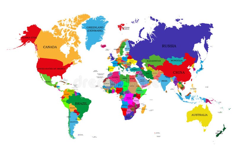
Free with trial Colored political world map with names of sovereign countries and larger dependent territories. Different colors for each countrie. S. Sudan vectors Colored political world map with names of sovereign countries and larger dependent territories. Different colors for each countrie. S
Free with trial Vector illustration of Africa map. Sudan vectors Africa map and country contours - Illustration. Vector illustration of Africa map. Vector illustration of Africa map.
Free with trial Middle East and Asia map - highly detailed vector illustration. Sudan vectors Middle East and Asia - map - illustration. Middle East and Asia map - highly detailed vector illustration. Middle East and Asia map - highly detailed vector illustration.
Free with trial Vector maps set. High detailed 46 maps of African countries with administrative division and cities. Political map, map of Africa continent, world map, globe, infographic elements. Part 1. Sudan vectors Vector maps set. High detailed 46 maps of African countries with administrative division and cities. Political map, map of Africa. Continent, world map, globe. Vector maps set. High detailed 46 maps of African countries with administrative division and cities. Political map, map of Africa continent, world map, globe, infographic elements. Part 1
Free with trial Vector maps set. High detailed 46 maps of African countries with administrative division and cities. Political map, map of Africa continent, world map, globe, infographic elements. Part 2. Sudan vectors Vector maps set. High detailed 46 maps of African countries with administrative division and cities. Political map, map of Africa. Continent, world map, globe. Vector maps set. High detailed 46 maps of African countries with administrative division and cities. Political map, map of Africa continent, world map, globe, infographic elements. Part 2
Free with trial Egypt map. Designed in illustration with regions colored in green colors. Vector illustration. Sudan vectors Egypt map. Designed in illustration with regions colored in green colors. Vector illustration
Free with trial Detailed vector illustration of 47 African country flags. Sudan vectors 47 African Country Flags. Detailed vector illustration of 47 African country flags. Detailed vector illustration of 47 African country flags.
Free with trial Egypt. Map of Egypt and Egyptian flag illustration. Sudan vectors Egypt. Map of Egypt and Egyptian flag illustration
Free with trial African flags. Illustration for you design. Sudan vectors African flags. Illustration for you design
Free with trial Vector illustration for the continent of Africa. Over 50 countries including several small islands, rivers and lakes not visible unless zoomed in. Very editable if needed. Sudan vectors African Continent Flag Map. Vector illustration for the continent of Africa. Over 50 countries including several small islands, rivers and lakes not visible. Vector illustration for the continent of Africa. Over 50 countries including several small islands, rivers and lakes not visible unless zoomed in. Very editable if needed.
Free with trial Vector flags. Africa, part 10. Set of detailed flags as textile ribbon tags. Sudan vectors Vector flags. Africa, part 10. Set of detailed flags as textile ribbon tags
Free with trial Vector Illustration showing African and black cultured flags for Black History Month. Sudan vectors Martin Luther King with kids. Vector Illustration showing African and black cultured flags for Black History Month. Vector Illustration showing African and black cultured flags for Black History Month.
 Sign in