Free with trial Vector logos collection of the 30 national basketball association (NBA) teams. Updated to 2016 - 2017. To state vectors NBA teams logos. Vector logos collection of the 30 national basketball association (NBA) teams. Updated to 2016 - 2017. Vector logos collection of the 30 national basketball association (NBA) teams. Updated to 2016 - 2017.
Free with trial Body silhouette practicing meditation, contemplating to the universe, cosmic connection, sunset sky, sun light rays and birds flying. A state of trance and deep meditation. A spiritual journey in the universe. Soul journey, enlightenment, flower of life, chakra, astral projection, spiritual awakening , soul healing concept. To state vectors Human body yoga, meditation, chakra spiritual energy healing, flower of life. Body silhouette practicing meditation, contemplating to the universe, cosmic. Body silhouette practicing meditation, contemplating to the universe, cosmic connection, sunset sky, sun light rays and birds flying. A state of trance and deep meditation. A spiritual journey in the universe. Soul journey, enlightenment, flower of life, chakra, astral projection, spiritual awakening , soul healing concept.
Free with trial Your Vote Counts Button/AI. Illustration of a button which urges people to exercise the right to vote... AI file available. To state vectors Your Vote Counts Button/AI. Illustration of a button which urges people to exercise the right to vote...AI file available
Free with trial Welcome to Florida. Vector illustration of Welcome to Florida, the sunshine state road sign. To state vectors Welcome to Florida. Vector illustration of Welcome to Florida, the sunshine state road sign
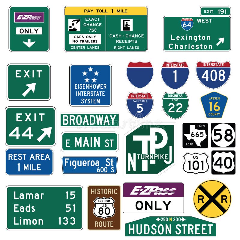
Free with trial Vector Illustration collection of the select Traffic Signs in the United States, isolated on white background. You can find other road signs in my portfolio. EPS file available. Guide signs are essential to direct road users along streets and highways, to inform them of intersecting routes, rnto direct them to cities, towns, villages, or other important destinations, to identify nearby rivers and streams, parks, forests, and historical sites, and generally to give such information as will help them along their way in the most simple, direct manner possible. rnrnIn the United States, road signs are, for the most part, standardized by federal regulations, most notably in the Manual on Uniform Traffic Control Devices (MUTCD) and its companion volume the Standard Highway Signs (SHS). There currently are no plans for adopting the Vienna Convention on Road Signs and Signals standards. Twenty-three states along with the District of Columbia and Puerto Rico use the manual without any alterations, 20 states have adopted it in conjunction with a supplemental volume, and seven states have a state version in substantial conformance to the MUTCD. There are also localized versions that are used in large cities such as New York City which use a naming system compatible with the MUTCD and/or state supplement. The MUTCD and SHS establish seven general categories of signs for road and highway use. rnrnIncluded illustrations are select examples of the MUTCD Guide Signs categories. rn. To state vectors Traffic Guide Signs in the United States. Vector Illustration collection of the select Traffic Signs in the United States, isolated on white background. You can. Vector Illustration collection of the select Traffic Signs in the United States, isolated on white background. You can find other road signs in my portfolio. EPS file available. Guide signs are essential to direct road users along streets and highways, to inform them of intersecting routes, rnto direct them to cities, towns, villages, or other important destinations, to identify nearby rivers and streams, parks, forests, and historical sites, and generally to give such information as will help them along their way in the most simple, direct manner possible.rnrnIn the United States, road signs are, for the most part, standardized by federal regulations, most notably in the Manual on Uniform Traffic Control Devices (MUTCD) and its companion volume the Standard Highway Signs (SHS). There currently are no plans for adopting the Vienna Convention on Road Signs and Signals standards. Twenty-three states along with the District of Columbia and Puerto Rico use the manual without any alterations, 20 states have adopted it in conjunction with a supplemental volume, and seven states have a state version in substantial conformance to the MUTCD. There are also localized versions that are used in large cities such as New York City which use a naming system compatible with the MUTCD and/or state supplement. The MUTCD and SHS establish seven general categories of signs for road and highway use.rnrnIncluded illustrations are select examples of the MUTCD Guide Signs categories.rn
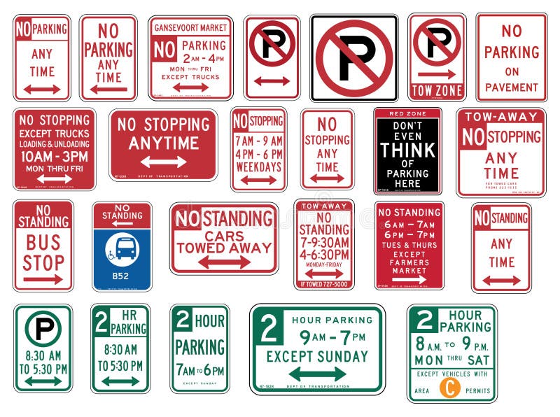
Free with trial Vector Illustration collection of the select Traffic Signs in the United States, isolated on white background. You can find other road signs in my portfolio. EPS file available. rnrnIn the United States, road signs are, for the most part, standardized by federal regulations, most notably in the Manual on Uniform Traffic Control Devices (MUTCD) and its companion volume the Standard Highway Signs (SHS). There currently are no plans for adopting the Vienna Convention on Road Signs and Signals standards. rnTwenty-three states along with the District of Columbia and Puerto Rico use the manual without any alterations, 20 states have adopted it in conjunction with a supplemental volume, and seven states have a state version in substantial conformance to the MUTCD. There are also localized versions that are used in large cities such as New York City which use a naming system compatible with the MUTCD and/or state supplement. The MUTCD and SHS establish seven general categories of signs for road and highway use. rnrnIncluded illustrations are select examples of the following MUTCD categories:rn-- R7 Series: Parkingrnrn. To state vectors Traffic Signs in the United States - No Parking. Vector Illustration collection of the select Traffic Signs in the United States, isolated on white background. Vector Illustration collection of the select Traffic Signs in the United States, isolated on white background. You can find other road signs in my portfolio. EPS file available.rnrnIn the United States, road signs are, for the most part, standardized by federal regulations, most notably in the Manual on Uniform Traffic Control Devices (MUTCD) and its companion volume the Standard Highway Signs (SHS). There currently are no plans for adopting the Vienna Convention on Road Signs and Signals standards.rnTwenty-three states along with the District of Columbia and Puerto Rico use the manual without any alterations, 20 states have adopted it in conjunction with a supplemental volume, and seven states have a state version in substantial conformance to the MUTCD. There are also localized versions that are used in large cities such as New York City which use a naming system compatible with the MUTCD and/or state supplement. The MUTCD and SHS establish seven general categories of signs for road and highway use.rnrnIncluded illustrations are select examples of the following MUTCD categories:rn-- R7 Series: Parkingrnrn
Free with trial A view of the world and it's most famous buildings. From left to right, the Roman Coliseum, Petronas Towers in Malaysia, Taj Mahal in India, St. Louis Arc, Eiffel Tower, Great Sphynx and Pyramid of Egypt, Empire State Building of New York, and the Sydney Opera House of Australia. (EPS, AI, JPG). To state vectors Explore Your World. A view of the world and it's most famous buildings. From left to right, the Roman Coliseum, Petronas Towers in Malaysia, Taj Mahal in India. A view of the world and it's most famous buildings. From left to right, the Roman Coliseum, Petronas Towers in Malaysia, Taj Mahal in India, St. Louis Arc, Eiffel Tower, Great Sphynx and Pyramid of Egypt, Empire State Building of New York, and the Sydney Opera House of Australia. (EPS, AI, JPG)
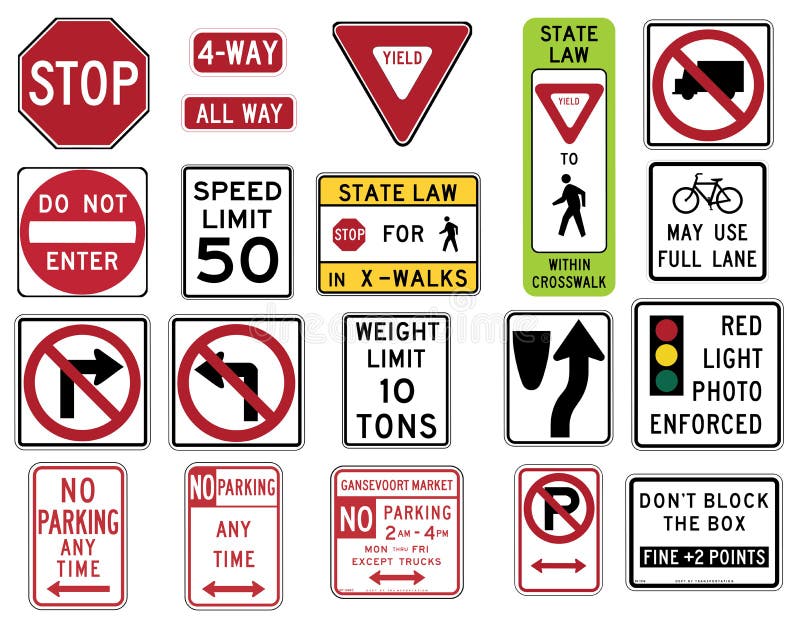
Free with trial Vector Illustration collection of the select Traffic Signs in the United States, isolated on white background. You can find other road signs in my portfolio. EPS file available. In the United States, road signs are, for the most part, standardized by federal regulations, most notably in the Manual on Uniform Traffic Control Devices (MUTCD) and its companion volume the Standard Highway Signs (SHS). There currently are no plans for adopting the Vienna Convention on Road Signs and Signals standards. Twenty-three states along with the District of Columbia and Puerto Rico use the manual without any alterations, 20 states have adopted it in conjunction with a supplemental volume, and seven states have a state version in substantial conformance to the MUTCD. There are also localized versions that are used in large cities such as New York City which use a naming system compatible with the MUTCD and/or state supplement. The MUTCD and SHS establish seven general categories of signs for road and highway use. Included illustrations are select examples of the following MUTCD categories: -- R1 Series STOP and YIELD -- R2 Series Speed Limit -- R3 Series Lane Usage and Turns (Left and Right Turn) -- R4 Regulation of Movement -- R5 Series: Exclusionary -- R7 Series: Parking. To state vectors Traffic Signs in the United States - Regulatory Series. Vector Illustration collection of the select Traffic Signs in the United States, isolated on white. Vector Illustration collection of the select Traffic Signs in the United States, isolated on white background. You can find other road signs in my portfolio. EPS file available. In the United States, road signs are, for the most part, standardized by federal regulations, most notably in the Manual on Uniform Traffic Control Devices (MUTCD) and its companion volume the Standard Highway Signs (SHS). There currently are no plans for adopting the Vienna Convention on Road Signs and Signals standards. Twenty-three states along with the District of Columbia and Puerto Rico use the manual without any alterations, 20 states have adopted it in conjunction with a supplemental volume, and seven states have a state version in substantial conformance to the MUTCD. There are also localized versions that are used in large cities such as New York City which use a naming system compatible with the MUTCD and/or state supplement. The MUTCD and SHS establish seven general categories of signs for road and highway use. Included illustrations are select examples of the following MUTCD categories: -- R1 Series STOP and YIELD -- R2 Series Speed Limit -- R3 Series Lane Usage and Turns (Left and Right Turn) -- R4 Regulation of Movement -- R5 Series: Exclusionary -- R7 Series: Parking
Free with trial Woman silhouette in yoga lotus pose sitting under a tree, in nature practicing meditation, contemplating to the stars, on a night purple sky, universe background. A state of trance and deep meditation. A spiritual journey in the universe. To state vectors Girl silhouette under a tree, meditation in nature, under stars. Woman silhouette in yoga lotus pose sitting under a tree, in nature practicing meditation. Woman silhouette in yoga lotus pose sitting under a tree, in nature practicing meditation, contemplating to the stars, on a night purple sky, universe background. A state of trance and deep meditation. A spiritual journey in the universe.
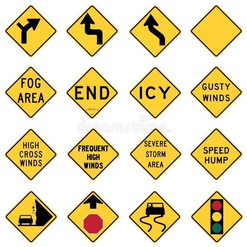
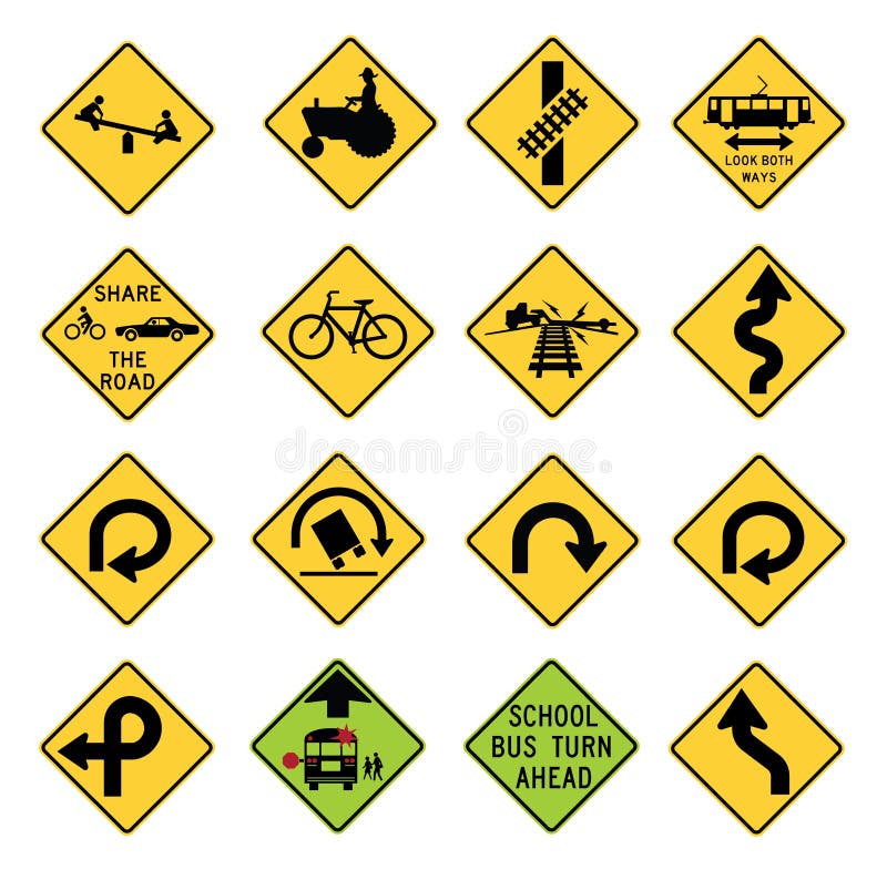
Free with trial Vector Illustration collection of the select Traffic Signs in the United States, isolated on white background. You can find other road signs in my portfolio. EPS file available. Warning signs are found in the W series of the national MUTCD. They highlight existing conditions, such as a curve, school, dead end street, or traffic signal. They can also warn possible danger such as bumps, bicycles, low flying aircraft or emergency vehicles. These signs are either yellow or fluorescent yellow in color and with the exception of a few signs are usually diamond shaped and sometimes have square or rectangular smaller signs or plaques associated with them. Most W series signs can also be found in with orange backgrounds, for temporary use in situations such as construction zones. Some of the temporary use signs are only for use in temporary situations. In the United States, road signs are, for the most part, standardized by federal regulations, most notably in the Manual on Uniform Traffic Control Devices (MUTCD) and its companion volume the Standard Highway Signs (SHS). There currently are no plans for adopting the Vienna Convention on Road Signs and Signals standards. Twenty-three states along with the District of Columbia and Puerto Rico use the manual without any alterations, 20 states have adopted it in conjunction with a supplemental volume, and seven states have a state version in substantial conformance to the MUTCD. There are also localized versions that are used in large cities such as New York City which use a naming system compatible with the MUTCD and/or state supplement. The MUTCD and SHS establish seven general categories of signs for road and highway use. Included illustrations are select examples of the MUTCD Warning Signs categories. To state vectors Traffic Warning Signs in the United States. Vector Illustration collection of the select Traffic Signs in the United States, isolated on white background. You. Vector Illustration collection of the select Traffic Signs in the United States, isolated on white background. You can find other road signs in my portfolio. EPS file available. Warning signs are found in the W series of the national MUTCD. They highlight existing conditions, such as a curve, school, dead end street, or traffic signal. They can also warn possible danger such as bumps, bicycles, low flying aircraft or emergency vehicles. These signs are either yellow or fluorescent yellow in color and with the exception of a few signs are usually diamond shaped and sometimes have square or rectangular smaller signs or plaques associated with them. Most W series signs can also be found in with orange backgrounds, for temporary use in situations such as construction zones. Some of the temporary use signs are only for use in temporary situations. In the United States, road signs are, for the most part, standardized by federal regulations, most notably in the Manual on Uniform Traffic Control Devices (MUTCD) and its companion volume the Standard Highway Signs (SHS). There currently are no plans for adopting the Vienna Convention on Road Signs and Signals standards. Twenty-three states along with the District of Columbia and Puerto Rico use the manual without any alterations, 20 states have adopted it in conjunction with a supplemental volume, and seven states have a state version in substantial conformance to the MUTCD. There are also localized versions that are used in large cities such as New York City which use a naming system compatible with the MUTCD and/or state supplement. The MUTCD and SHS establish seven general categories of signs for road and highway use. Included illustrations are select examples of the MUTCD Warning Signs categories.
Free with trial Vector Illustration collection of the select Traffic Signs in the United States, isolated on white background. You can find other road signs in my portfolio. EPS file available. Warning signs are found in the W series of the national MUTCD. They highlight existing conditions, such as a curve, school, dead end street, or traffic signal. They can also warn possible danger such as bumps, bicycles, low flying aircraft or emergency vehicles. These signs are either yellow or fluorescent yellow in color and with the exception of a few signs are usually diamond shaped and sometimes have square or rectangular smaller signs or plaques associated with them. Most W series signs can also be found in with orange backgrounds, for temporary use in situations such as construction zones. Some of the temporary use signs are only for use in temporary situations. In the United States, road signs are, for the most part, standardized by federal regulations, most notably in the Manual on Uniform Traffic Control Devices (MUTCD) and its companion volume the Standard Highway Signs (SHS). There currently are no plans for adopting the Vienna Convention on Road Signs and Signals standards. Twenty-three states along with the District of Columbia and Puerto Rico use the manual without any alterations, 20 states have adopted it in conjunction with a supplemental volume, and seven states have a state version in substantial conformance to the MUTCD. There are also localized versions that are used in large cities such as New York City which use a naming system compatible with the MUTCD and/or state supplement. The MUTCD and SHS establish seven general categories of signs for road and highway use. Included illustrations are select examples of the MUTCD Warning Signs categories. To state vectors Traffic Warning Signs in the United States. Vector Illustration collection of the select Traffic Signs in the United States, isolated on white background. You. Vector Illustration collection of the select Traffic Signs in the United States, isolated on white background. You can find other road signs in my portfolio. EPS file available. Warning signs are found in the W series of the national MUTCD. They highlight existing conditions, such as a curve, school, dead end street, or traffic signal. They can also warn possible danger such as bumps, bicycles, low flying aircraft or emergency vehicles. These signs are either yellow or fluorescent yellow in color and with the exception of a few signs are usually diamond shaped and sometimes have square or rectangular smaller signs or plaques associated with them. Most W series signs can also be found in with orange backgrounds, for temporary use in situations such as construction zones. Some of the temporary use signs are only for use in temporary situations. In the United States, road signs are, for the most part, standardized by federal regulations, most notably in the Manual on Uniform Traffic Control Devices (MUTCD) and its companion volume the Standard Highway Signs (SHS). There currently are no plans for adopting the Vienna Convention on Road Signs and Signals standards. Twenty-three states along with the District of Columbia and Puerto Rico use the manual without any alterations, 20 states have adopted it in conjunction with a supplemental volume, and seven states have a state version in substantial conformance to the MUTCD. There are also localized versions that are used in large cities such as New York City which use a naming system compatible with the MUTCD and/or state supplement. The MUTCD and SHS establish seven general categories of signs for road and highway use. Included illustrations are select examples of the MUTCD Warning Signs categories.
Free with trial Woman silhouette in yoga lotus pose practicing meditation, contemplating to the stars, on a night sky, with stars and glowing lights, universe background. A state of trance and deep meditation. A spiritual journey in the universe. To state vectors Mountain girl silhouette, meditation under stars. Woman silhouette in yoga lotus pose practicing meditation, contemplating to the stars, on a night sky, with. Woman silhouette in yoga lotus pose practicing meditation, contemplating to the stars, on a night sky, with stars and glowing lights, universe background. A state of trance and deep meditation. A spiritual journey in the universe.
Free with trial Georgia state map by counties to monitor and show state activity in different areas, can be used in flash and web, vector option. To state vectors Georgia USA state map by counties. Georgia state map by counties to monitor and show state activity in different areas, can be used in flash and web, vector. Georgia state map by counties to monitor and show state activity in different areas, can be used in flash and web, vector option.
Free with trial Woman silhouette practicing yoga, meditation, contemplating to the universe, cosmic connection, colorful nebula, eye background and star light rays. A state of trance and deep meditation. A spiritual journey into the universe. Soul journey, enlightenment, astral projection, spiritual awakening, healing concept. To state vectors Silhouette yoga meditation, universe, nebula, healing, human body energy beams. Woman silhouette practicing yoga, meditation, contemplating to the universe. Woman silhouette practicing yoga, meditation, contemplating to the universe, cosmic connection, colorful nebula, eye background and star light rays. A state of trance and deep meditation. A spiritual journey into the universe. Soul journey, enlightenment, astral projection, spiritual awakening, healing concept.
Free with trial United States map by states in various high levels. Abstraction of parts of a whole. This icon serves as idea of level of platforms to show data information related to every state. To state vectors United States map by states image logo high levels. United States map by states in various high levels. Abstraction of parts of a whole. This icon serves as idea. United States map by states in various high levels. Abstraction of parts of a whole. This icon serves as idea of level of platforms to show data information related to every state.
Free with trial Homeostasis vector illustration. Labeled educational glucose example scheme. Internal physical and chemical state condition to maintain living systems. Body temperature, fluid balance and blood sugar. To state vectors Homeostasis vector illustration. Labeled educational glucose example scheme. Internal physical and chemical state condition to maintain living systems. Body
Free with trial Vector illustration with travel landmarks. including silhouettes of most famous landmarks and monuments of all the continents, from eiffel tower to coliseum, with cool coloured background. To state vectors World landmarks background. Vector illustration with travel landmarks. including silhouettes of most famous landmarks and monuments of all the continents, from. Vector illustration with travel landmarks. including silhouettes of most famous landmarks and monuments of all the continents, from eiffel tower to coliseum, with cool coloured background
Free with trial Home icon. Main page button. Navigation sign. Black silhouette symbol isolated on white background. Simple vector icon for web site design or button to mobile app. To state vectors Home icon. Main page button. Navigation sign. Black silhouette symbol isolated on white background. Simple vector icon for web site design or button to mobile
Free with trial Illustration of united states of america as a 3d map with stylized men and network wire on it, related to communications, networking and social, vector file available. To state vectors United states as network map. Illustration of united states of america as a 3d map with stylized men and network wire on it, related to communications. Illustration of united states of america as a 3d map with stylized men and network wire on it, related to communications, networking and social, vector file available
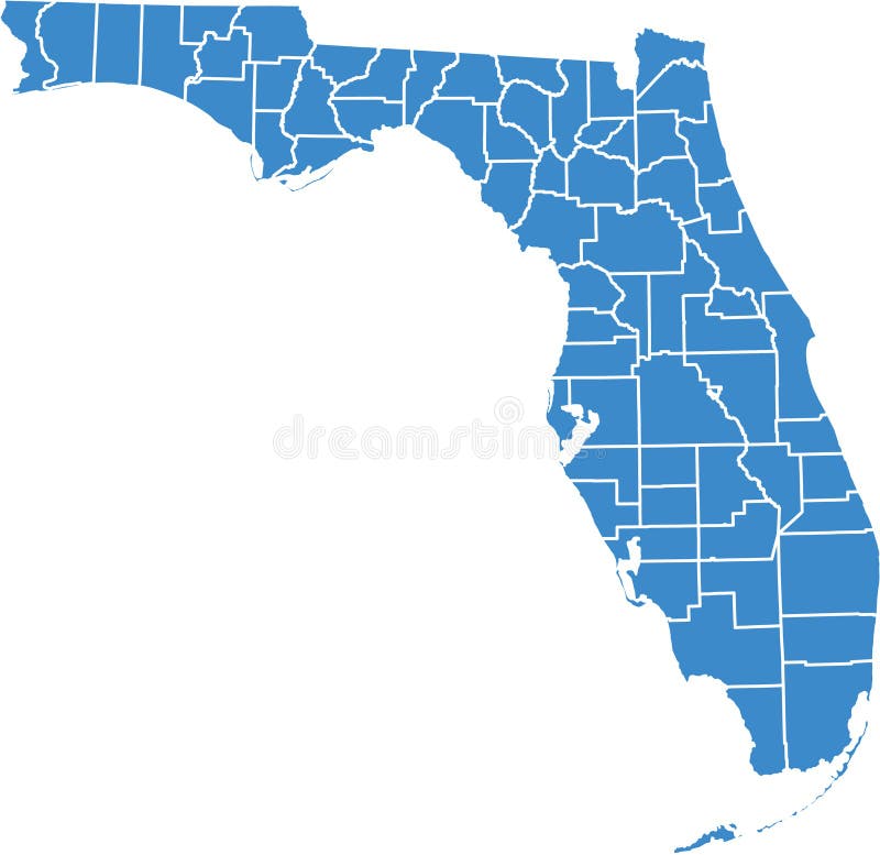
Free with trial Florida by counties. County by county florida, vector option, to monitor state activity in different areas, can be used in flash and web. To state vectors Florida by counties. County by county florida, vector option, to monitor state activity in different areas, can be used in flash and web
Free with trial Copy space to add your own message and address on the backside or photo to the front of this retro postcard. EPS8 organized in groups for easy editing. To state vectors Postcard, Add Location. Copy space to add your own message and address on the backside or photo to the front of this retro postcard. EPS8 organized in groups for. Copy space to add your own message and address on the backside or photo to the front of this retro postcard. EPS8 organized in groups for easy editing.
Free with trial Three States of Matter. Easy to edit vector illustration of three states of matter. To state vectors Three States of Matter. Easy to edit vector illustration of three states of matter
Free with trial Very detailed buttons of all fifty states. States are organized alphabetically let to right, top to bottom. To state vectors Fifty states button set. Very detailed buttons of all fifty states. States are organized alphabetically let to right, top to bottom. Very detailed buttons of all fifty states. States are organized alphabetically let to right, top to bottom.
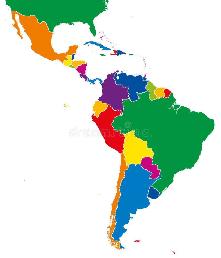
Free with trial Latin America single states political map. Countries in different colors, with national borders and English country names. From Mexico to the southern tip of South America, including the Caribbean. To state vectors Latin America single states political map. Countries in different colors, with national borders and English country names. From Mexico to the southern tip of
Free with trial Molecules liquid have enough energy to move relative to each other. In a gas the effect of intermolecular forces is small. In a solid the particles molecules are packed closely together. To state vectors Fundamental states of matter. Molecules liquid have enough energy to move relative to each other. In a gas the effect of intermolecular forces is small. In a. Molecules liquid have enough energy to move relative to each other. In a gas the effect of intermolecular forces is small. In a solid the particles molecules are packed closely together.
Free with trial USA map showing all states with two-letter state abbreviations. Clipped to US border. To state vectors USA Map. Showing all states with two-letter state abbreviations. Clipped to US border
Free with trial Flat vector illustration with stylized travel map of Ireland. The landmarks and main cities like Dublin and Belfast. Text Welcome to Ireland. To state vectors Travel map of Ireland with landmarks and cities. Flat vector illustration with stylized travel map of Ireland. The landmarks and main cities like Dublin and. Flat vector illustration with stylized travel map of Ireland. The landmarks and main cities like Dublin and Belfast. Text Welcome to Ireland
Free with trial A heat pump works similarly like refrigerator. During the heating season it heat from outside to inside and the opposite is true during the summer months. A heat pump actually moves heat rather than generates heat. To state vectors How does a heat pump work?. A heat pump works similarly like refrigerator. During the heating season it heat from outside to inside and the opposite is true. A heat pump works similarly like refrigerator. During the heating season it heat from outside to inside and the opposite is true during the summer months. A heat pump actually moves heat rather than generates heat
Free with trial Tax control of shopping. The big brother looks. Don't forget to pay taxes. All our purchases are seen by the big brother from the tax inspection. To state vectors Tax control of shopping. The big brother looks. Don't forget to pay taxes. All our purchases are seen by the big brother from the tax inspection
Free with trial Latin America single states map. All countries in different full intense colors and with national borders. From northern border of Mexico to the southern tip of South America, including the Caribbean. To state vectors Latin America single states map full color. Latin America single states map. All countries in different full intense colors and with national borders. From. Latin America single states map. All countries in different full intense colors and with national borders. From northern border of Mexico to the southern tip of South America, including the Caribbean.
Free with trial Background illustration of a family walking to a carnival or fair under a sky of fireworks. To state vectors Family Fair Fireworks/eps. Background illustration of a family walking to a carnival or fair under a sky of fireworks. Background illustration of a family walking to a carnival or fair under a sky of fireworks.
Free with trial World flags in alphabetical order. World flags in alphabetical order from A to Z drawing by illustration. To state vectors World flags in alphabetical order. From A to Z drawing by illustration. World flags in alphabetical order.World flags in alphabetical order from A to Z drawing by illustration
Free with trial All European flags. All elements and textures are individual objects. Vector illustration scale to any size. To state vectors All European flags. All elements and textures are individual objects. Vector illustration scale to any size
Free with trial European country flags and map. All elements and textures are individual objects. Vector illustration scale to any size. To state vectors European country flags and map. All elements and textures are individual objects. Vector illustration scale to any size
Free with trial Vector world flags web buttons. Two hundred world flags web buttons with details ready to use. To state vectors Vector world flags web buttons. Two hundred world flags web buttons with details ready to use
Free with trial Evaporation vector illustration. Labeled liquid surface substance change to gas state scheme. Educational explanation diagram with nature phenomenon when sun heats warm water and triggers rising vapor. To state vectors Evaporation vector illustration. Labeled liquid to gas state process scheme. Evaporation vector illustration. Labeled liquid surface substance change to gas. Evaporation vector illustration. Labeled liquid surface substance change to gas state scheme. Educational explanation diagram with nature phenomenon when sun heats warm water and triggers rising vapor
Free with trial Tired woman tied to kettlebell, exhausted girl, female character feeling powerless, low energy state, physical or emotional burnout, mental fatigue, responsibility overload, stuck in problems. To state vectors Tired woman tied to kettlebell, exhausted girl, female character feeling powerless, low energy state, responsibility overload. Tired woman tied to kettlebell. Tired woman tied to kettlebell, exhausted girl, female character feeling powerless, low energy state, physical or emotional burnout, mental fatigue, responsibility overload, stuck in problems
Free with trial Welcome to Michigan vintage rusty metal sign vector illustration. Vector state map in grunge style with Typography hand drawn. Lettering. Vector illustration. To state vectors Welcome to Michigan vintage rusty metal sign vector illustration. Vector state map in grunge style with Typography hand drawn. Lettering. Vector illustration
Free with trial State of Water infographic solid ice liquid and vapor gas with physical characteristics and properties of shape volume and force between molecules transition from one state to another for education. To state vectors State of Water infographic. Solid ice liquid and vapor gas with physical characteristics and properties of shape volume and force between molecules transition. State of Water infographic solid ice liquid and vapor gas with physical characteristics and properties of shape volume and force between molecules transition from one state to another for education
Free with trial Pennsylvania State by counties. Vector to edit counties Pennsylvania State by counties. To state vectors Pennsylvania State by counties. Vector to edit counties Pennsylvania State by counties
Free with trial Physical Map of India with different state. Easy to edit vector illustration of Physical Map of India with different state. To state vectors Physical Map of India with different state. Easy to edit vector illustration of Physical Map of India with different state
Free with trial Man light silhouette practicing meditation, contemplating to the universe, cosmic connection, dark night sky with stars and glowing light rays. A state of trance and deep meditation. A spiritual journey to the universe. Soul journey, enlightenment, astral projection, spiritual awakening, spiritual essence of man, chakras, reiki, inverted tree of life concept. To state vectors Man universe, meditation, healing, human body energy, Kabbalah tree of life. Man light silhouette practicing meditation, contemplating to the universe, cosmic. Man light silhouette practicing meditation, contemplating to the universe, cosmic connection, dark night sky with stars and glowing light rays. A state of trance and deep meditation. A spiritual journey to the universe. Soul journey, enlightenment, astral projection, spiritual awakening, spiritual essence of man, chakras, reiki, inverted tree of life concept.
Free with trial USA map with states. And colorful background to hightlight each state. To state vectors USA map with states. And colorful background to hightlight each state
Free with trial Man silhouette in yoga lotus pose practicing meditation, contemplating to the stars, on a full moon night sky, universe background. A state of trance and deep meditation. A spiritual journey in the universe. To state vectors Man silhouette in moonlight, meditation under stars, full moon on night sky. Man silhouette in yoga lotus pose practicing meditation, contemplating to the stars. Man silhouette in yoga lotus pose practicing meditation, contemplating to the stars, on a full moon night sky, universe background. A state of trance and deep meditation. A spiritual journey in the universe.
Free with trial Matter from molecule to quark. For example of a water molecules. Microcosm & Macrocosm. To state vectors Matter from molecule to quark. For example of a water molecules. Microcosm & Macrocosm
Free with trial Welcome to Virginia road sign. Vector illustration of the Welcome to Virginia `Virginia is for lovers` black road sign. To state vectors Welcome to Virginia road sign. Vector illustration of the Welcome to Virginia `Virginia is for lovers` black road sign
Free with trial Welcome to Arizona vintage rusty metal sign. On a white background, vector illustration. To state vectors Welcome to Arizona vintage rusty metal sign. On a white background, vector illustration
Free with trial Welcome to Alabama vintage rusty metal sign. On a white background, vector illustration. To state vectors Welcome to Alabama vintage rusty metal sign. On a white background, vector illustration
Free with trial Welcome to Mississippi road sign. Vector illustration of the Welcome to Mississippi blue road sign. To state vectors Welcome to Mississippi road sign. Vector illustration of the Welcome to Mississippi blue road sign
Free with trial Fundamentals states of matter with molecules vector infographics. Phase of matter from to solid, illustration of different physics phase state. To state vectors Fundamentals states of matter with molecules vector infographics. Phase of matter from to solid, illustration of different physics phase state
Free with trial Map of Africa. Detail color map of African continent with borders. Each state is colored to the various color and has wrote the name. To state vectors Map of Africa. Detail color map of African continent with borders. Each state is colored to the various color and has wrote the name
Free with trial Changes of states. Part 2 of 6. Evaporation - water boiling. Phase transition from liquid to gaseous state. Educational infographics. Cartoon vector illustration in flat style. To state vectors Changes of states. Evaporation - water boiling. Changes of states. Part 2 of 6. Evaporation - water boiling. Phase transition from liquid to gaseous state. Changes of states. Part 2 of 6. Evaporation - water boiling. Phase transition from liquid to gaseous state. Educational infographics. Cartoon vector illustration in flat style.
Free with trial How to use oxygen mask on the plane in emergency case. Flight instruction. Passenger showing process of breathing mask usage. Isolated vector illustration in cartoon style. To state vectors How to use oxygen mask on the plane in emergency case. Flight instruction. Passenger showing process of breathing mask usage. Isolated vector illustration in
Free with trial How to deal with stress guide. Depression reduce instruction. Making exercise and yoga, sleep and deep breath help to reduce stressful state. Isolated flat vector illustration. To state vectors How to deal with stress guide. Depression reduce. Instruction. Making exercise and yoga, sleep and deep breath help to reduce stressful state. Isolated flat
Free with trial Register to Vote Banner with American Flag. Register to Vote! Your VOTE is your VOICE Banner with American Flag. To state vectors Register to Vote Banner with American Flag. Register to Vote! Your VOTE is your VOICE Banner with American Flag
Free with trial Welcome to Texas road sign. Vector illustration of the Welcome to Texas road sign. To state vectors Welcome to Texas road sign. Vector illustration of the Welcome to Texas road sign
Free with trial Politician to build a wall on the USA border. United States flag. Illegal migration. Vintage pop art retro vector illustration. Brickwork. To state vectors Politician to build a wall on the USA border. United States flag. Illegal migration. Vintage pop art retro vector illustration. Brickwork
Free with trial Welcome to North Carolina road sign. Vector illustration of the Welcome to North Carolina green road sign with North Carolina flag. To state vectors Welcome to North Carolina road sign. Vector illustration of the Welcome to North Carolina green road sign with North Carolina flag
Free with trial Background with the state symbol of Ukraine. Background to congratulating on the day of independence of Ukraine. To state vectors Background with the state symbol of Ukraine. Background to congratulating on the day of independence of Ukraine
Free with trial Vector illustration of world most famous monuments, including silhouettes of most famous landmarks and monuments of all the continents, from eiffel tower to coliseum, with cool coloured background. To state vectors Travel landmarks background. Vector illustration of world most famous monuments, including silhouettes of most famous landmarks and monuments of all the. Vector illustration of world most famous monuments, including silhouettes of most famous landmarks and monuments of all the continents, from eiffel tower to coliseum, with cool coloured background
Free with trial Typical refrigeration cycle. vector diagram. How it works. The compressor constricts the refrigerant vapor, raising its pressure. When the hot gas the it becomes a liquid. Liquid form at high pressure, the refrigerant cools down. The refrigerant absorbs the heat inside the fridge, cooling down the air. The refrigerant evaporates to a gas, then flows back to the compressor, where the cycle starts. To state vectors Typical refrigeration cycle. Vector diagram. How it works. The compressor constricts the refrigerant vapor, raising its pressure. When the hot gas the it
Free with trial Africa map outline of states. Geographic map of the continent with borders of states, related to education, travel, vector file available. To state vectors Africa map outline of states. Geographic map of the continent with borders of states, related to education, travel, vector file available
Free with trial Your vote. Illustration of a button which urges people to exercise the right to vote. To state vectors Your vote. Illustration of a button which urges people to exercise the right to vote
Free with trial Mexico vintage metal signs. Greetings from Mexico. Retro souvenir or postcard template. Welcome to Mexico. To state vectors Mexico vintage metal signs. Greetings from Mexico. Retro souvenir or postcard template. Welcome to Mexico
Free with trial Illustration of south africa with road signs for each biggest city, including cape town and port elizabeth, related to travel, soccer world cup and education, vector file available. To state vectors South africa 3d map with cities. Illustration of south africa with road signs for each biggest city, including cape town and port elizabeth, related to travel. Illustration of south africa with road signs for each biggest city, including cape town and port elizabeth, related to travel, soccer world cup and education, vector file available
Free with trial These icons with a fleur de lis superimposed on a hurricane symbol have come to be recognized as a symbol of New Orleans, Louisiana since Hurricane Katrina. The fleur de lis is the Louisiana state symbol. To state vectors Hurricane Fleur de Lis Symbols. These icons with a fleur de lis superimposed on a hurricane symbol have come to be recognized as a symbol of New Orleans. These icons with a fleur de lis superimposed on a hurricane symbol have come to be recognized as a symbol of New Orleans, Louisiana since Hurricane Katrina. The fleur de lis is the Louisiana state symbol.
Free with trial Nepal political map with capital Kathmandu, national borders, cities and rivers. Federal democratic republic and landlocked country in South Asia, bordered to China and India. English labeling. To state vectors Nepal Political Map. With capital Kathmandu, national borders, cities and rivers. Federal democratic republic and landlocked country in South Asia, bordered to. Nepal political map with capital Kathmandu, national borders, cities and rivers. Federal democratic republic and landlocked country in South Asia, bordered to China and India. English labeling.
Free with trial Professional icons for your website, application, or presentation. Vector icons: illustrator and other compatible applications Easy to edit, resize or colorize Bitmap icons: High Resolution JPG image. To state vectors Real State Icons | Indigo Serie 01. Professional icons for your website, application, or presentation. Vector icons: illustrator and other compatible. Professional icons for your website, application, or presentation. Vector icons: illustrator and other compatible applications Easy to edit, resize or colorize Bitmap icons: High Resolution JPG image
Free with trial Full size front and back 8. 5 x 5. 5 retro postcard in blue. Copy space to add your own text, address or photo. EPS8 compatible; organized in groups for easy editing. To state vectors Postcard, Add Location. Full size front and back 8.5 x 5.5 retro postcard in blue. Copy space to add your own text, address or photo. EPS8 compatible; organized. Full size front and back 8.5 x 5.5 retro postcard in blue. Copy space to add your own text, address or photo. EPS8 compatible; organized in groups for easy editing.
Free with trial Blood pressure chart. From young people to old people. To state vectors Blood pressure chart. From young people to old people
Free with trial Brazil map outlined with cities. Map of brazil with star where the capital city brasilia is located, related to travel and education, vector file available. To state vectors Brazil map outlined with cities. Map of brazil with star where the capital city brasilia is located, related to travel and education, vector file available
Free with trial Normal and malfunctioning vein valves. Diagram to show the action of normal vein valves and in the diseased malfunctioning state. To state vectors Normal and malfunctioning vein valves. Diagram to show the action of normal vein valves and in the diseased malfunctioning state
Free with trial Spectroscopy labeled vector illustration. Matter and electromagnetic radiation. Study of visible light dispersed according to its wavelength, by a prism. Physics basics. To state vectors Spectroscopy vector illustration. Matter and electromagnetic radiation. Spectroscopy labeled vector illustration. Matter and electromagnetic radiation. Study of. Spectroscopy labeled vector illustration. Matter and electromagnetic radiation. Study of visible light dispersed according to its wavelength, by a prism. Physics basics.
Free with trial Latin America political map with capitals, national borders, rivers and lakes. Countries from northern border of Mexico to southern tip of South America, including the Caribbean. English labeling. To state vectors Latin America political map. With capitals, national borders, rivers and lakes. Countries from northern border of Mexico to southern tip of South America. Latin America political map with capitals, national borders, rivers and lakes. Countries from northern border of Mexico to southern tip of South America, including the Caribbean. English labeling.
Free with trial Fasting vector illustration. Flat tiny metabolism diet time person concept. Modern and healthy method for weight loss and positive effect. Daily meal schedule and plan to stay in ketogenic state. To state vectors Fasting vector illustration. Flat tiny metabolism diet time person concept. Modern and healthy method for weight loss and positive effect. Daily meal schedule
Free with trial Detailed map of Nigeria. Each file is constructed using multiple layers including country borders, county names, main roads and a highly detailed state silhouette. Each file is fully customizable with the ability to change the color of individual counties to suit your needs. To state vectors Nigeria map. Detailed map of Nigeria. Each file is constructed using multiple layers including country borders, county names, main roads and a highly detailed. Detailed map of Nigeria. Each file is constructed using multiple layers including country borders, county names, main roads and a highly detailed state silhouette. Each file is fully customizable with the ability to change the color of individual counties to suit your needs.
Free with trial Set of black and white flat glyph icons relating to New York City, USA. To state vectors New York icon set. Set of black and white flat glyph icons relating to New York City, USA. Set of black and white flat glyph icons relating to New York City, USA.
Free with trial Globe set with with borders of world countries. Easy to select every country and delete contour of borders. Contain the Clipping Path. There is in addition a vector format (EPS 8). To state vectors Globe set with borders of countries. Globe set with with borders of world countries. Easy to select every country and delete contour of borders. Contain the. Globe set with with borders of world countries. Easy to select every country and delete contour of borders. Contain the Clipping Path. There is in addition a vector format (EPS 8)
Free with trial Latin America countries political map with national borders. Countries from the northern border of Mexico to the southern tip of South America, including the Caribbean. English labeling. Illustration. To state vectors Latin America countries political map. With national borders. Countries from the northern border of Mexico to the southern tip of South America, including the. Latin America countries political map with national borders. Countries from the northern border of Mexico to the southern tip of South America, including the Caribbean. English labeling. Illustration.
Free with trial Each file is constructed using multiple layers including country borders, county names, main roads and a highly detailed state silhouette. Each file is fully customizable with the ability to change the color of individual counties to suit your needs. To state vectors Canada map. Each file is constructed using multiple layers including country borders, county names, main roads and a highly detailed state silhouette. Each file. Each file is constructed using multiple layers including country borders, county names, main roads and a highly detailed state silhouette. Each file is fully customizable with the ability to change the color of individual counties to suit your needs.
 Sign in