Free with trial Luggage stickers Tennessee, South Carolina, North Carolina. Illustrations of south eastern united states. Waterway vectors Luggage stickers Tennessee, South Carolina, North Carolina. Illustrations of south eastern united states
Free with trial Vancouver Skyline is a vector illustration. Waterway vectors Vancouver Skyline-Vector. Vancouver Skyline is a vector illustration. Vancouver Skyline is a vector illustration.
Free with trial Waves with bubbles. And splashes sky line behind. Waterway vectors Waves with bubbles. And splashes sky line behind
Free with trial Big Ben, London, England, UK. Hand Drawn Illustration. Vector vintage background. illustration collection. Scrapbooking hand drawing kit. Waterway vectors Big Ben, London, England, UK. Travel Europe old-fashioned background. Big Ben, London, England, UK. Hand Drawn Illustration. Vector vintage background. Big Ben, London, England, UK. Hand Drawn Illustration. Vector vintage background. illustration collection. Scrapbooking hand drawing kit.
Free with trial Old sailing ship. Isolated on white. Waterway vectors Old sailing ship. Isolated on white
Free with trial Cruise ship bon voyage illustration. Cruise ship illustration with Bon Voyage headline. Waterway vectors Cruise ship bon voyage illustration. Cruise ship illustration with Bon Voyage headline
Free with trial Adirondack chair sitting on a dock, looking out at the water.. awaiting someone to enjoy the view. Waterway vectors Tranquility at the lake. Adirondack chair sitting on a dock, looking out at the water.. awaiting someone to enjoy the view. Adirondack chair sitting on a dock, looking out at the water.. awaiting someone to enjoy the view..
Free with trial Political map of Panama Canal with cross-section, cities, rivers and lakes. Vector illustration with english labeling, description and scaling. Waterway vectors Panama Canal Political Map. Political map of Panama Canal with cross-section, cities, rivers and lakes. Vector illustration with english labeling, description. Political map of Panama Canal with cross-section, cities, rivers and lakes. Vector illustration with english labeling, description and scaling.
Free with trial Panama political map with capital Panama City, national borders, most important cities, rivers and lakes. Illustration with English labeling and scaling. Vector. Waterway vectors Panama Political Map. With capital Panama City, national borders, most important cities, rivers and lakes. Illustration with English labeling and scaling
Free with trial Pastel sailboat. Pastel patterned sailboat. Waterway vectors Pastel sailboat. Pastel patterned sailboat
Free with trial Strait of Hormuz, political map. Waterway between Persian Gulf and Gulf of Oman, a strategically extremely important choke point, with Iran to the north and UAE and Oman exclave Musandam to the south. Waterway vectors Strait of Hormuz, waterway between Persian Gulf and Gulf of Oman, map. Strait of Hormuz, political map. Waterway between Persian Gulf and Gulf of Oman, a. Strait of Hormuz, political map. Waterway between Persian Gulf and Gulf of Oman, a strategically extremely important choke point, with Iran to the north and UAE and Oman exclave Musandam to the south.
Free with trial Venice. View of Venice with the Rialto Bridge. Waterway vectors Venice. View of Venice with the Rialto Bridge
Free with trial Garden House. Can use in many stuf such as children stuff and more. Waterway vectors Garden House. Can use in many stuf such as children stuff and more
Free with trial Chrome luxury siphon - illustration for the web. Waterway vectors Chrome luxury siphon. Illustration for the web
Free with trial Green forest and river. Vector cartoon drawing of a beautiful forest river. Waterway vectors Green forest and river. Vector cartoon drawing of a beautiful forest river
Free with trial Warning buoy off the coast. Isolated on blue background. Waterway vectors Warning buoy off the coast. Isolated on blue background
Free with trial This is an Illustration of a pelican. Waterway vectors Pelican. This is an Illustration of a pelican. This is an Illustration of a pelican.
Free with trial Stream. Boy trying to catch a fish in a country stream. Waterway vectors Stream. Boy trying to catch a fish in a country stream
Free with trial Shanghai water village Zhouzhuang in China. Vector illustration of Shanghai water village Zhouzhuang in China. Waterway vectors Shanghai water village Zhouzhuang in China. Vector illustration of Shanghai water village Zhouzhuang in China
Free with trial Vancouver Skyline is a vector illustration. Waterway vectors Vancouver Skyline-Vector. Vancouver Skyline is a vector illustration. Vancouver Skyline is a vector illustration.
Free with trial Typical house along the canal. Hand drawing of typical house along the canal near Bangkok in Thailand. Waterway vectors Typical house along the canal. Hand drawing of typical house along the canal near Bangkok in Thailand
Free with trial Set of popular realistic pipe U siphons for wash basin, sanitary devices, plumbing fixtures, metal, nickel, chrome luxury for connection to sewer pipe for labels of cleaners, printed materials. Waterway vectors Set of popular realistic pipe U siphons for wash basin. Sanitary devices, plumbing fixtures, metal, nickel, chrome luxury for connection to sewer pipe for. Set of popular realistic pipe U siphons for wash basin, sanitary devices, plumbing fixtures, metal, nickel, chrome luxury for connection to sewer pipe for labels of cleaners, printed materials
Free with trial Cargo ship pass river - vector illustration. Waterway vectors Cargo ship pass river. Vector illustration
Free with trial Indo-Pacific major energy SLOCs, political map. Geopolitically critical Sea Lines Of Communication. Primary maritime routes between ports, used for trade, logistics and naval forces. Illustration. Waterway vectors Indo-Pacific major energy SLOCs, Sea Lines Of Communication, map. Indo-Pacific major energy SLOCs, political map. Geopolitically critical Sea Lines Of. Indo-Pacific major energy SLOCs, political map. Geopolitically critical Sea Lines Of Communication. Primary maritime routes between ports, used for trade, logistics and naval forces. Illustration.
Free with trial Vector map of the Great Lakes, USA, Canada. Waterway vectors Vector map of the Great Lakes, USA, Canada.
Free with trial The Bridge of Lions is a double-leaf bascule bridge that spans the Intracoastal Waterway in St. Augustine, Florida, United States, vector illustration. Waterway vectors The Bridge of Lions, Florida, United States. The Bridge of Lions is a double-leaf bascule bridge that spans the Intracoastal Waterway in St. Augustine, Florida. The Bridge of Lions is a double-leaf bascule bridge that spans the Intracoastal Waterway in St. Augustine, Florida, United States, vector illustration
Free with trial Washbasin clogged with water leaking out. Sink. Vector illustration. Waterway vectors Washbasin clogged with water leaking out. Sink . Vector. Illustration
Free with trial Suez Canal, political map. An artificial sea-level waterway in Egypt, connecting the Mediterranean Sea to the Red Sea, dividing Africa and Asia. It extends from Port Said to Suez. Illustration. Vector. Waterway vectors Suez Canal, artificial sea-level waterway in Egypt, political map. Suez Canal, political map. An artificial sea-level waterway in Egypt, connecting the. Suez Canal, political map. An artificial sea-level waterway in Egypt, connecting the Mediterranean Sea to the Red Sea, dividing Africa and Asia. It extends from Port Said to Suez. Illustration. Vector
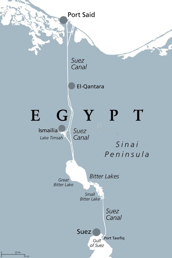
Free with trial Suez Canal, gray political map. Artificial sea-level waterway in Egypt, connecting the Mediterranean Sea to the Red Sea, dividing Africa and Asia, extends from Port Said to Suez. Illustration. Vector. Waterway vectors Suez Canal, artificial sea-level waterway in Egypt, gray political map. Suez Canal, gray political map. Artificial sea-level waterway in Egypt, connecting the. Suez Canal, gray political map. Artificial sea-level waterway in Egypt, connecting the Mediterranean Sea to the Red Sea, dividing Africa and Asia, extends from Port Said to Suez. Illustration. Vector.
Free with trial Panama Canal,gray political map. Artificial waterway in Panama,connecting Atlantic Ocean (Caribbean Sea) with Pacific Ocean,cutting across the Isthmus of Panama,reducing the travel time for ships. Waterway vectors Panama Canal, artificial waterway in Panama, gray political map. Panama Canal,gray political map. Artificial waterway in Panama,connecting Atlantic Ocean (. Panama Canal,gray political map. Artificial waterway in Panama,connecting Atlantic Ocean (Caribbean Sea) with Pacific Ocean,cutting across the Isthmus of Panama,reducing the travel time for ships.
Free with trial Panama Canal,political map. Artificial waterway in Panama,connecting the Atlantic Ocean (Caribbean Sea) with Pacific Ocean,cutting across the Isthmus of Panama,reducing the travel time for ships. Waterway vectors Panama Canal, artificial waterway in Panama, political map. Panama Canal,political map. Artificial waterway in Panama,connecting the Atlantic Ocean (Caribbean. Panama Canal,political map. Artificial waterway in Panama,connecting the Atlantic Ocean (Caribbean Sea) with Pacific Ocean,cutting across the Isthmus of Panama,reducing the travel time for ships.
Free with trial Strait of Gibraltar, waterway between Spain and Morocco vector map. Waterway vectors Strait of Gibraltar, waterway between Spain and Morocco vector map.
Free with trial Prohibition for canoes and rowing boats on the waterway. Waterway vectors Prohibition for canoes and rowing boats on the waterway. Prohibition sign no canoes and rowing boats on the waterway
Free with trial Strait of Hormuz, gray political map. Waterway between Persian Gulf and Gulf of Oman. Strategically very important choke point, with Iran to the north and UAE and Oman exclave Musandam to the south. Waterway vectors Strait of Hormuz, an important waterway, gray political map. Strait of Hormuz, gray political map. Waterway between Persian Gulf and Gulf of Oman. Strategically. Strait of Hormuz, gray political map. Waterway between Persian Gulf and Gulf of Oman. Strategically very important choke point, with Iran to the north and UAE and Oman exclave Musandam to the south.
Free with trial Vector map of the Oeresund waterway between Sweden and Denmark. Waterway vectors Vector map of the Oeresund waterway between Sweden and Denmark.
Free with trial Bifurcation buoys for ship traffic separation on the waterway. Waterway vectors Bifurcation buoys for ship traffic separation on the waterway.
Free with trial Vector map of the 82 kilometer long waterway Panama Canal, Panama. Waterway vectors Vector map of the 82 kilometer long waterway Panama Canal, Panama.
Free with trial Canal/Waterway Brick Bridge Logo Design Inspiration. isolated on white background EPS10. Waterway vectors Canal/Waterway Brick Bridge Logo Design Inspiration. Isolated on white background EPS10
Free with trial Camera/Waterway Brick Bridge Logo Design Inspiration. isolated on white background EPS10. Waterway vectors Camera/Waterway Brick Bridge Logo Design Inspiration. Isolated on white background EPS10
Free with trial Canal/Waterway Brick Bridge Logo Design Inspiration. isolated on white background EPS10. Waterway vectors Canal/Waterway Brick Bridge Logo Design Inspiration. Isolated on white background EPS10
Free with trial Realistic pipe with clogged drain in canalization. Cleaning clogged piping waterway, clog waste blocked plastic siphon isolated on white background. Template realistic 3d vector illustration. Waterway vectors Realistic pipe with clogged drain canalization. Cleaning clogged piping waterway realistic element. Realistic pipe with clogged drain in canalization. Cleaning. Realistic pipe with clogged drain in canalization. Cleaning clogged piping waterway, clog waste blocked plastic siphon isolated on white background. Template realistic 3d vector illustration
Free with trial Suez Canal political map. Artificial sea-level waterway on Sinai Peninsula in Egypt, connecting Mediterranean Sea and Red Sea. Gray illustration on white background. English labeling. Vector. Waterway vectors Suez Canal political map. Artificial sea-level waterway on Sinai Peninsula in Egypt, connecting Mediterranean Sea and Red Sea. Gray illustration on white
Free with trial Suez Canal Political Map. Artificial sea-level waterway in Egypt, connecting the Mediterranean Sea and the Red Sea. English labeling and scaling. Illustration. Waterway vectors Suez Canal Political Map. Artificial sea-level waterway in Egypt, connecting the Mediterranean Sea and the Red Sea. English labeling and scaling. Illustration
Free with trial The Bosporus or Bosphorus, political map. The Strait of Istanbul, a narrow, natural strait and international waterway in Turkey. It connects the Black Sea with the Sea of Marmara. Illustration. Vector. Waterway vectors The Bosporus or Bosphorus, Strait of Istanbul, political map. The Bosporus or Bosphorus, political map. The Strait of Istanbul, a narrow, natural strait and. The Bosporus or Bosphorus, political map. The Strait of Istanbul, a narrow, natural strait and international waterway in Turkey. It connects the Black Sea with the Sea of Marmara. Illustration. Vector
Free with trial Taiwan Strait,gray political map. Important waterway and disputed international waters,separating the island of Taiwan and continental Asia,which connects the East China Sea and South China Sea. Waterway vectors Taiwan Strait, separating Taiwan and continental Asia, gray political map. Taiwan Strait,gray political map. Important waterway and disputed international waters. Taiwan Strait,gray political map. Important waterway and disputed international waters,separating the island of Taiwan and continental Asia,which connects the East China Sea and South China Sea.
Free with trial An aerial view vector landscape of a river delta, depicting a detailed landscape from above and natural waterway formations, ideal for nature themes and designs celebrating rivers, deltas, and the expansive beauty of landscapes from high vantage points vector design Generative AI. Waterway vectors Aerial view river delta, landscape from above, vector design Generative AI. An aerial view vector landscape of a river delta, depicting a detailed landscape from. An aerial view vector landscape of a river delta, depicting a detailed landscape from above and natural waterway formations, ideal for nature themes and designs celebrating rivers, deltas, and the expansive beauty of landscapes from high vantage points vector design Generative AI
Free with trial An infographic of microbeads in beauty product. They are flushed into waterway, polluted the ocean,then poison fish. Microplastic pollution concept. Vector illustration. Waterway vectors Microbead Pollution Product. An infographic of microbeads in beauty product. They are flushed into waterway, polluted the ocean,then poison fish. Microplastic. An infographic of microbeads in beauty product. They are flushed into waterway, polluted the ocean,then poison fish. Microplastic pollution concept. Vector illustration
Free with trial Wastewater from washing machine consist of microfiber, leaching into waterway. Plastic pollution concept. Vector illustration. Waterway vectors Microfiber Pollution Clothing. Wastewater from washing machine consist of microfiber, leaching into waterway. Plastic pollution concept. Vector illustration. Wastewater from washing machine consist of microfiber, leaching into waterway. Plastic pollution concept. Vector illustration
Free with trial Wastewater from washing machine consist of microfibers which are invisbile and leaching into waterway. Plastic pollution concept. Vector illustration. Waterway vectors Invisible Microfiber Pollution. Wastewater from washing machine consist of microfibers which are invisbile and leaching into waterway. Plastic pollution concept. Wastewater from washing machine consist of microfibers which are invisbile and leaching into waterway. Plastic pollution concept. Vector illustration
Free with trial Clogged In Water Canalization Pipe Cleaning Vector. Clean Clogged Piping Waterway Service, Clog Blocked in Plastic Siphon. Repair, Renewal And Fix Sanitary Cleaner Layout Realistic 3d Illustration. Waterway vectors Clogged In Water Canalization Pipe Cleaning Vector. Clean Clogged Piping Waterway Service, Clog Blocked in Plastic Siphon. Repair, Renewal And Fix Sanitary
Free with trial A classic vector illustration of a vintage paddle steamer gracefully navigating a river, evoking the romance of oldworld travel. This detailed depiction of a historic riverboat is perfect for themes of transportation, history, Americana, or scenic waterway journeys. A nostalgic graphic for a bygone era of river exploration, vector design Generative AI. Waterway vectors Vintage Paddle Steamer Vector Art, Historic Riverboat Illustration, vector design Generative AI. A classic vector illustration of a vintage paddle steamer. A classic vector illustration of a vintage paddle steamer gracefully navigating a river, evoking the romance of oldworld travel. This detailed depiction of a historic riverboat is perfect for themes of transportation, history, Americana, or scenic waterway journeys. A nostalgic graphic for a bygone era of river exploration, vector design Generative AI
Free with trial Panama Canal,political map and schematic diagram,illustrating the sequence of locks and passages. An artificial waterway,connecting the Atlantic Ocean with the Pacific Ocean,and expanded in 2016. Waterway vectors Panama Canal, political map and schematic diagram of locks and passages. Panama Canal,political map and schematic diagram,illustrating the sequence of locks and. Panama Canal,political map and schematic diagram,illustrating the sequence of locks and passages. An artificial waterway,connecting the Atlantic Ocean with the Pacific Ocean,and expanded in 2016.
Free with trial Canal Bridge. A British Canal Bridge with Towpath. Waterway vectors Canal Bridge. A British Canal Bridge with Towpath
Free with trial Meander. Abstract design of a meandering river. Waterway vectors Meander. Abstract design of a meandering river
Free with trial Typical house along the canal near Bangkok in Thai. Hand drawing of typical house along the canal near Bangkok in Thailand. Waterway vectors Typical house along the canal near Bangkok in Thai. Hand drawing of typical house along the canal near Bangkok in Thailand
Free with trial Chrome luxury siphon - illustration for the web. Waterway vectors Chrome luxury siphon. Illustration for the web
Free with trial Waterway Signs, Prohibitory. Prohibitory signs for river navigation, illustration. Waterway vectors Waterway Signs, Prohibitory. Prohibitory signs for river navigation, illustration
Free with trial Vector low poly icebreaker breaking the ice. In the ocean. Waterway vectors Vector low poly icebreaker breaking the ice. In the ocean
Free with trial A warning buoy off the coast. Doodle style. Waterway vectors A warning buoy off the coast. Doodle style
Free with trial Isometric illustration of an old European Amsterdam canal street with historic narrow houses, boats, bridge, trees and. Promenade in a classic Dutch cityscape. Waterway vectors Isometric illustration of an old European Amsterdam canal street with historic narrow houses, boats, bridge, trees and. Promenade in a classic Dutch cityscape
Free with trial Cartoon summer scenery. Vector cartoon drawing of a beautiful summer river and flower meadows. Waterway vectors Cartoon summer scenery. Vector cartoon drawing of a beautiful summer river and flower meadows
Free with trial Venice, from Rialto Bridge with gondola. Waterway vectors Venice. From Rialto Bridge with gondola
Free with trial Set of aeroplane, bus, car, ship and train icons. Waterway vectors Transportation icons. Set of aeroplane, bus, car, ship and train icons. Set of aeroplane, bus, car, ship and train icons.
Free with trial Warning buoy off the coast. Isolated on blue background. Waterway vectors Warning buoy off the coast. Isolated on blue background
Free with trial Bosporus and Dardanelles, political map. The Turkish Straits, internationally significant and narrow waterways in Turkey. Passages, connecting the Aegean Sea and the Sea of Marmara with the Black Sea. Waterway vectors Bosporus and Dardanelles, the Turkish Straits, political map. Bosporus and Dardanelles, political map. The Turkish Straits, internationally significant and. Bosporus and Dardanelles, political map. The Turkish Straits, internationally significant and narrow waterways in Turkey. Passages, connecting the Aegean Sea and the Sea of Marmara with the Black Sea.
Free with trial This illustration is abstract if not plumbing services can like sea, call now can feel weather in template. Waterway vectors Plumbing service sea cover. This illustration is abstract if not plumbing services can like sea, call now can feel weather in template. This illustration is abstract if not plumbing services can like sea, call now can feel weather in template.
Free with trial Ile Saint Louis in Paris, France - vector illustration Ideal for printing on fabric or paper, poster or wallpaper, house decoration. Waterway vectors Ile Saint Louis in Paris, France. Vector illustration Ideal for printing on fabric or paper, poster or wallpaper, house decoration
Free with trial Eco Pond. With a rooster awakening the day and a duck swimming in pond. Waterway vectors Eco Pond. With a rooster awakening the day and a duck swimming in pond
Free with trial Waterway Signs, Additional. Additional signs for river navigation, illustration navigation. Waterway vectors Waterway Signs, Additional. Additional signs for river navigation, illustration navigation
Free with trial Machinac Bridge_Vector. Machinac Bridge looking north across the Straits. Waterway vectors Machinac Bridge_Vector. Machinac Bridge looking north across the Straits
Free with trial Swamp Boat ride AirBoat. Vector illustration clip-art. Waterway vectors Swamp Boat ride AirBoat. Vector illustration clip-art
Free with trial Vector low poly icebreaker breaking the ice. Vector low poly icebreaker breaking path through the ice in the ocean for tanker ship. Waterway vectors Vector low poly icebreaker breaking the ice. Vector low poly icebreaker breaking path through the ice in the ocean for tanker ship
Free with trial An illustration of a small container ship vessel, sitting in port, ready for loading and unloading. E. P. S. 10 vector file included with image, isolated on white. Waterway vectors Container ship and dock crane. An illustration of a small container ship vessel, sitting in port, ready for loading and unloading. E.P.S. 10 vector file included. An illustration of a small container ship vessel, sitting in port, ready for loading and unloading. E.P.S. 10 vector file included with image, isolated on white.
Free with trial Set of thin line icons water transport and sea port, platform. Set of thin line icons water transport and sea port, oil platform, dry cargo ship, bulk carrier. Waterway vectors Set of thin line icons water transport and sea port, platform. Set of thin line icons water transport and sea port, oil platform, dry cargo ship, bulk carrier
Free with trial Narrow Boat coloring page for kids. Narrow Boat side view isolated on white background. Waterway vectors Narrow Boat coloring page for kids. Narrow Boat. Side view isolated on white background
Free with trial Lighthouse 1. Hand drawn popular style lighthouse building. Waterway vectors Lighthouse 1. Hand drawn popular style lighthouse building
Free with trial Strait of Hormuz region political map. English labeling. Strait between the Persian Gulf and the Gulf of Oman. The only sea passage from the Persian Gulf to the open ocean. Gray illustration. Vector. Waterway vectors Strait of Hormuz region political map. English labeling. Strait between the Persian Gulf and the Gulf of Oman. The only sea passage from the Persian Gulf to
Free with trial Canalization airtrap siphon black symbol - illustration for the web. Waterway vectors Canalization airtrap siphon black symbol. Illustration for the web
Free with trial The Seine river road sign. Vector illustration of The Seine river black road sign on metallic pole. Waterway vectors The Seine river road sign. Vector illustration of The Seine river black road sign on metallic pole
 Sign in