Free with trial Hispaniola Political Map with Haiti and Dominican Republic, located in the Caribbean island group, the Greater Antilles. With capitals, national borders, important cities, rivers and lakes. English labeling and scaling. Illustration. Windward vectors Hispaniola Political Map with Haiti and Dominican Republic. Located in the Caribbean island group, the Greater Antilles. With capitals, national borders. Hispaniola Political Map with Haiti and Dominican Republic, located in the Caribbean island group, the Greater Antilles. With capitals, national borders, important cities, rivers and lakes. English labeling and scaling. Illustration.
Free with trial Rooster weather vane. Weathercock silhouette, rooster weather vane. Windward vectors Rooster weather vane. Weathercock silhouette, rooster weather vane
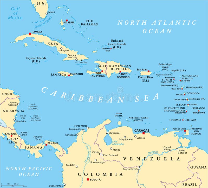
Free with trial Caribbean political map with capitals, national borders, important cities, rivers and lakes. English labeling and scaling. Illustration. Windward vectors Caribbean Political Map. With capitals, national borders, important cities, rivers and lakes. English labeling and scaling. Illustration
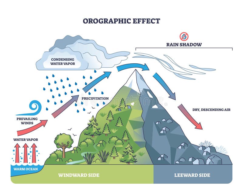
Free with trial Orographic effect vector illustration. Labeled weather system movement scheme. Educational diagram with windward and leeward side. Prevailing winds, precipitation and condensing water vapor phenomena. Windward vectors Orographic effect vector illustration. Labeled weather system move scheme. Orographic effect vector illustration. Labeled weather system movement scheme. Orographic effect vector illustration. Labeled weather system movement scheme. Educational diagram with windward and leeward side. Prevailing winds, precipitation and condensing water vapor phenomena.
Free with trial Illustration of a detailed political map of Cape Verde, with its islands, mountains and volcanos. Windward vectors Cape Verde map. Illustration of a detailed political map of Cape Verde, with its islands, mountains and volcanos. Illustration of a detailed political map of Cape Verde, with its islands, mountains and volcanos.
Free with trial Barbados Political Map with capital Bridgetown, with important cities, places and rivers. English labeling and scaling. Illustration. Windward vectors Barbados Political Map. With capital Bridgetown, with important cities, places and rivers. English labeling and scaling. Illustration
Free with trial Vector and rasterized nautical symbols. Created in Corel Draw. Windward vectors Nautical vector & rasterized symbols. Vector and rasterized nautical symbols. Created in Corel Draw. Vector and rasterized nautical symbols. Created in Corel Draw.
Free with trial Orographic effect shows moist air rising over mountains, causing rain on the windward side and dry air on the leeward. Key objects, mountain, clouds, rain. Outline diagram. Windward vectors Orographic effect shows moist air rising over mountains, causing rain ... Orographic effect shows moist air rising over mountains, causing rain on the windward. Orographic effect shows moist air rising over mountains, causing rain on the windward side and dry air on the leeward. Key objects, mountain, clouds, rain. Outline diagram
Free with trial Caribbean. Passport stamp of the Windward Islands of the Caribbean in vector format. Windward vectors Caribbean. Passport stamp of the Windward Islands of the Caribbean in vector format
Free with trial Illustration a silhouette of a wind vane. A Witch and a cat are sitting on it. W, E letters are my own design. Available in vector EPS format. Windward vectors Halloween's weathervane with silhouettes of a Witch and a cat. Illustration a silhouette of a wind vane. A Witch and a cat are sitting on it. W, E letters are my. Illustration a silhouette of a wind vane. A Witch and a cat are sitting on it. W, E letters are my own design. Available in vector EPS format.
Free with trial Steering-wheel, vector illustration. Steering-wheel on a white background. Windward vectors Steering-wheel, vector illustration. Steering-wheel on a white background
Free with trial A compass (or mariner compass) is a navigational instrument for finding directions on the Earth. It consists of a magnetized pointer free to align itself accurately with Earth's magnetic field, which is of great assistance in navigation. Windward vectors Compass in old style (black). A compass (or mariner compass) is a navigational instrument for finding directions on the Earth. It consists of a magnetized. A compass (or mariner compass) is a navigational instrument for finding directions on the Earth. It consists of a magnetized pointer free to align itself accurately with Earth's magnetic field, which is of great assistance in navigation.
Free with trial The Caribbean, colored political map. Subregion of the Americas in the Caribbean Sea with its islands and English names. The Greater Antilles and the Lesser Antilles. Isolated illustration over white. Windward vectors The Caribbean, subregion of the Americas, colored political map. The Caribbean, colored political map. Subregion of the Americas in the Caribbean Sea with its. The Caribbean, colored political map. Subregion of the Americas in the Caribbean Sea with its islands and English names. The Greater Antilles and the Lesser Antilles. Isolated illustration over white.
Free with trial Windward Islands, gray political map. Islands of Lesser Antilles, south of Leeward Islands in the Caribbean Sea. From Dominica, Martinique, Saint Lucia, Saint Vincent and the Grenadines, to Grenada. Windward vectors Windward Islands, gray political map, islands in the Caribbean Sea. Windward Islands, gray political map. Islands of Lesser Antilles, south of Leeward Islands in. Windward Islands, gray political map. Islands of Lesser Antilles, south of Leeward Islands in the Caribbean Sea. From Dominica, Martinique, Saint Lucia, Saint Vincent and the Grenadines, to Grenada.
Free with trial Hurricane free Caribbean islands, political map. The Leeward Antilles and Windward Islands are safest from Hurricanes. Aruba, Barbados, Bonaire, Curacao, Grenada, The Grenadines, Trinidad and Tobago. Windward vectors Hurricane free Caribbean islands, map of Leeward Antilles and Windward Islands. Hurricane free Caribbean islands, political map. The Leeward Antilles and. Hurricane free Caribbean islands, political map. The Leeward Antilles and Windward Islands are safest from Hurricanes. Aruba, Barbados, Bonaire, Curacao, Grenada, The Grenadines, Trinidad and Tobago.
Free with trial Eastern Caribbean islands, gray political map. Puerto Rico, Virgin Islands, Leeward and Windward Islands, and part of the Leeward Antilles north the coast of Venezuela, located in the Caribbean Sea. Windward vectors Eastern Caribbean islands, Leeward and Windward Islands, gray political map. Eastern Caribbean islands, gray political map. Puerto Rico, Virgin Islands, Leeward. Eastern Caribbean islands, gray political map. Puerto Rico, Virgin Islands, Leeward and Windward Islands, and part of the Leeward Antilles north the coast of Venezuela, located in the Caribbean Sea.
Free with trial Hurricane free Caribbean islands, gray political map. Leeward Antilles and Windward Islands are safest from hurricanes. Aruba, Barbados, Bonaire, Curacao, Grenada, The Grenadines, Trinidad and Tobago. Windward vectors Hurricane free Caribbean islands, gray map of Leeward Antilles and Windward Islands. Hurricane free Caribbean islands, gray political map. Leeward Antilles and. Hurricane free Caribbean islands, gray political map. Leeward Antilles and Windward Islands are safest from hurricanes. Aruba, Barbados, Bonaire, Curacao, Grenada, The Grenadines, Trinidad and Tobago.
Free with trial Windward Islands political map. Islands of the Lesser Antilles, south of the Leeward Islands in the Caribbean Sea. From Dominica, Martinique, Saint Lucia, Saint Vincent and the Grenadines, to Grenada. Windward vectors Windward Islands, political map, islands of Lesser Antilles in the Caribbean. Windward Islands political map. Islands of the Lesser Antilles, south of the. Windward Islands political map. Islands of the Lesser Antilles, south of the Leeward Islands in the Caribbean Sea. From Dominica, Martinique, Saint Lucia, Saint Vincent and the Grenadines, to Grenada.
Free with trial Avalanches weather explanation from geologic view in outline diagram. Labeled educational scheme with windward, cornice or leeward as environment to build up snow on mountain peak vector illustration. Windward vectors Avalanches weather explanation from geologic side view in outline diagram. Avalanches weather explanation from geologic view in outline diagram. Labeled. Avalanches weather explanation from geologic view in outline diagram. Labeled educational scheme with windward, cornice or leeward as environment to build up snow on mountain peak vector illustration.
Free with trial Grenada political map with capital St George`s. Caribbean islands country and part of the Lesser Antilles and Windward Islands. Gray illustration isolated on white background. English labeling. Vector. Windward vectors Grenada political map. With capital St George`s. Caribbean islands country and part of the Lesser Antilles and Windward Islands. Gray illustration isolated on. Grenada political map with capital St George`s. Caribbean islands country and part of the Lesser Antilles and Windward Islands. Gray illustration isolated on white background. English labeling. Vector
Free with trial Trinidad and Tobago political map with capital Port of Spain. Twin island country in the Windward Islands and Lesser Antilles. English labeling and scaling. Illustration. Windward vectors Trinidad and Tobago Political Map. With capital Port of Spain. Twin island country in the Windward Islands and Lesser Antilles. English labeling and scaling
Free with trial Barbados, Grenada, Saint Lucia, Saint Vincent and the Grenadines political map. Caribbean islands, part of Lesser Antilles and Windward Islands. Gray illustration over white. English labeling. Vector. Windward vectors Barbados, Grenada, Saint Lucia, Saint Vincent political map. Barbados, Grenada, Saint Lucia, Saint Vincent and the Grenadines political map. Caribbean islands. Barbados, Grenada, Saint Lucia, Saint Vincent and the Grenadines political map. Caribbean islands, part of Lesser Antilles and Windward Islands. Gray illustration over white. English labeling. Vector.
Free with trial Lesser Antilles of the Caribbean, multicolored political map. Group of islands between Greater Antilles and South America. Divided into the Leeward Islands, Windward Islands, and the Leeward Antilles. Windward vectors Lesser Antilles of the Caribbean, multicolored political map. Group of islands between Greater Antilles and South America. Divided into the Leeward Islands
Free with trial Society Islands,gray political map. Group of volcanic islands,in French Polynesia. Overseas collectivity of France in the South Pacific Ocean. Archipelago,divided into Leeward and Windward Islands. Windward vectors Society Islands, island group in French Polynesia, gray political map. Society Islands,gray political map. Group of volcanic islands,in French Polynesia. Society Islands,gray political map. Group of volcanic islands,in French Polynesia. Overseas collectivity of France in the South Pacific Ocean. Archipelago,divided into Leeward and Windward Islands.
Free with trial Tahiti, French Polynesia, political map. Largest island of the Windward group of the Society Islands, with capital Papeete. Overseas collectivity of France, located in the South Pacific Ocean. Vector. Windward vectors Tahiti, French Polynesia, a part of the Society Islands, political map. Tahiti, French Polynesia, political map. Largest island of the Windward group of the. Tahiti, French Polynesia, political map. Largest island of the Windward group of the Society Islands, with capital Papeete. Overseas collectivity of France, located in the South Pacific Ocean. Vector.
Free with trial The Caribbean countries political map with national borders. The Caribbean Sea with Greater, Lesser and Leeward Antilles, with West Indies and parts of Central and South America. English labeling. Windward vectors The Caribbean countries political map. With national borders. The Caribbean Sea with Greater, Lesser and Leeward Antilles, with West Indies and parts of Central. The Caribbean countries political map with national borders. The Caribbean Sea with Greater, Lesser and Leeward Antilles, with West Indies and parts of Central and South America. English labeling.
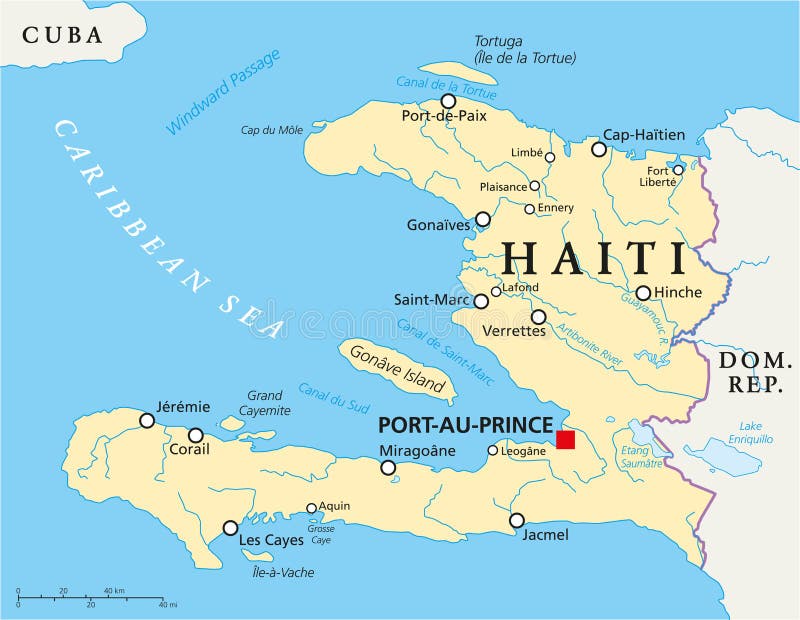
Free with trial Haiti Political Map with capital Port-au-Prince, with national borders, important cities, rivers and lakes. English labeling and scaling. Illustration. Windward vectors Haiti Political Map. With capital Port-au-Prince, with national borders, important cities, rivers and lakes. English labeling and scaling. Illustration
Free with trial Guadeloupe, Dominica, Martinique political map with capitals Basse-Terre, Roseau and Fort-de-France. Caribbean islands, parts of Lesser Antilles. Gray illustration over white. English labeling. Vector. Windward vectors Guadeloupe, Dominica, Martinique political map. With capitals Basse-Terre, Roseau and Fort-de-France. Caribbean islands, parts of Lesser Antilles. Gray. Guadeloupe, Dominica, Martinique political map with capitals Basse-Terre, Roseau and Fort-de-France. Caribbean islands, parts of Lesser Antilles. Gray illustration over white. English labeling. Vector
Free with trial Netherlands Antilles Political Map. Aruba, Curacao, Bonaire, Sint Maarten, Saba and Sint Eustatius with capitals and important cities. English labeling and scaling. Illustration. Windward vectors Netherlands Antilles Political Map. Aruba, Curacao, Bonaire, Sint Maarten, Saba and Sint Eustatius with capitals and important cities. English labeling and
Free with trial Martinique political map with capital Fort-de-France and important places. Overseas region of France in the Lesser Antilles region of the Caribbean Sea. English labeling and scaling. Illustration. Windward vectors Martinique Political Map. With capital Fort-de-France and important places. Overseas region of France in the Lesser Antilles region of the Caribbean Sea. Martinique political map with capital Fort-de-France and important places. Overseas region of France in the Lesser Antilles region of the Caribbean Sea. English labeling and scaling. Illustration.
Free with trial Hawaiian islands map. Detailed map of the entire Hawaiian archipelago. Windward vectors Hawaiian islands map. Detailed map of the entire Hawaiian archipelago
Free with trial Saint Vincent and the Grenadines political map with capital Kingstown. Island country in the Lesser Antilles Island arc. English labeling and scaling. Illustration. Windward vectors Saint Vincent and the Grenadines Political Map. With capital Kingstown. Island country in the Lesser Antilles Island arc. English labeling and scaling
Free with trial Guadeloupe, Dominica and Martinique political map with capitals Basse-Terre, Roseau and Fort-de-France. Islands in Caribbean Sea and parts of Lesser Antilles. Illustration. English labeling. Vector. Windward vectors Guadeloupe, Dominica and Martinique political map. With capitals Basse-Terre, Roseau and Fort-de-France. Islands in Caribbean Sea and parts of Lesser Antilles. Guadeloupe, Dominica and Martinique political map with capitals Basse-Terre, Roseau and Fort-de-France. Islands in Caribbean Sea and parts of Lesser Antilles. Illustration. English labeling. Vector.
Free with trial Hawaiian Islands, Sandwich Islands, gray political map. U. S. state of Hawaii with capital Honolulu, and unincorporated territory Midway Atoll. Archipelago in North Pacific Ocean. Illustration. Vector. Windward vectors Hawaiian Islands, Sandwich Islands, gray political map. U.S. state of Hawaii with capital Honolulu, and unincorporated territory Midway Atoll. Archipelago in
Free with trial Leeward Islands, political map. Part of the Lesser Antilles, north of Windward Islands in the Caribbean. Virgin Islands, Anguilla, St Kitts and Nevis, Antigua and Barbuda, Montserrat, and Guadeloupe. Windward vectors Leeward Islands, political map, part of Lesser Antilles in the Caribbean. Leeward Islands, political map. Part of the Lesser Antilles, north of Windward Islands. Leeward Islands, political map. Part of the Lesser Antilles, north of Windward Islands in the Caribbean. Virgin Islands, Anguilla, St Kitts and Nevis, Antigua and Barbuda, Montserrat, and Guadeloupe.
Free with trial The Caribbean Sea and its islands, gray political map. The Caribbean, subregion of the Americas, with the West Indies, compromising independent island countries and dependencies in three archipelagos. Windward vectors The Caribbean Sea and its islands, gray political map. The Caribbean, subregion of the Americas, with the West Indies, compromising independent island
Free with trial A compass (or mariner compass) is a navigational instrument for finding directions on the Earth. It consists of a magnetized pointer free to align itself accurately with Earth's magnetic field, which is of great assistance in navigation. Windward vectors Compass in old style , vector illustration. A compass (or mariner compass) is a navigational instrument for finding directions on the Earth. It consists of a. A compass (or mariner compass) is a navigational instrument for finding directions on the Earth. It consists of a magnetized pointer free to align itself accurately with Earth's magnetic field, which is of great assistance in navigation.
Free with trial Republic of Haiti road vector map. Windward vectors Republic of Haiti road vector map.
Free with trial Vector map of the Caribbean island of Martinique, France. Windward vectors Vector map of the Caribbean island of Martinique, France.
Free with trial Island groups of the West Indies, political map. Subregion of the Americas, surrounded by North Atlantic Ocean and Caribbean Sea. Greater Antilles, Lesser Antilles, and Lucayan Archipelago. Windward vectors Island groups of the West Indies, subregion of the Americas, political map. Island groups of the West Indies, political map. Subregion of the Americas. Island groups of the West Indies, political map. Subregion of the Americas, surrounded by North Atlantic Ocean and Caribbean Sea. Greater Antilles, Lesser Antilles, and Lucayan Archipelago.
Free with trial Dominica, Stamp Postal. Silhouette Seal. Passport Round Design. Vector Icon. Design Retro Travel. National Symbol Generative AI. Windward vectors Dominica, Stamp Postal Silhouette Seal Generative AI. Dominica, Stamp Postal. Silhouette Seal. Passport Round Design. Vector Icon. Design Retro Travel. National. Dominica, Stamp Postal. Silhouette Seal. Passport Round Design. Vector Icon. Design Retro Travel. National Symbol Generative AI.
Free with trial Vector road map of the island of Moorea in French Polynesia. Windward vectors Vector road map of the island of Moorea in French Polynesia.
Free with trial Administrative map of the Caribbean island of Martinique, France. Windward vectors Administrative map of the Caribbean island of Martinique, France.
Free with trial Saint lucia administrative and political vector map. Windward vectors Saint lucia administrative and political vector map.
Free with trial Ship world. Sailing ship around of the world. Windward vectors Ship world. Sailing ship around of the world
Free with trial Rooster weather vane glyph icon, farming and agriculture, sign vector graphics, a solid pattern on a white background, eps 10. Windward vectors Rooster weather vane glyph icon, farming. And agriculture, sign vector graphics, a solid pattern on a white background, eps 10
Free with trial Weathervane - Black running rooster3. Isolated on white background. Windward vectors Weathervane - Black running rooster3. Isolated on white background
Free with trial Vector map of the three SSS islands, Netherlands Antilles. Windward vectors Vector map of the three SSS islands, Netherlands Antilles.
Free with trial Vector weather vane rooster, weathercock line icon. Symbol and sign illustration design. Isolated on white background. Windward vectors Weather vane rooster, weathercock line icon. Vector weather vane rooster, weathercock line icon. Symbol and sign illustration design. Isolated on white. Vector weather vane rooster, weathercock line icon. Symbol and sign illustration design. Isolated on white background
Free with trial Weathervane icon set. logo with a rooster. Vector illustration. Windward vectors Set rooster weathervane. Weathervane icon set. logo with a rooster. Vector illustration. Weathervane icon set. logo with a rooster. Vector illustration.
Free with trial 3D Isometric Flat Vector Conceptual Illustration of Foehn Wind, Chinook Warm Effect. Windward vectors 3D Isometric Flat Vector Conceptual Illustration of Foehn Wind. Chinook Warm Effect
Free with trial White weather vane with icon, flat style. White weather vane with icon in flat style on a white background. Windward vectors White weather vane with icon, flat style. White weather vane with icon in flat style on a white background
Free with trial Weather vane rooster. flat vector icon. simple flat vector icon illustration. outline line symbol - editable stroke. Windward vectors Weather vane rooster. flat vector icon. Weather vane rooster. simple flat vector icon illustration. outline line symbol - editable stroke
Free with trial Weather vane with icon, simple style. Weather vane with icon in simple style isolated vector illustration. Windward vectors Weather vane with icon, simple style. Weather vane with icon in simple style isolated vector illustration
Free with trial White weather vane with icon, flat style. White weather vane with icon in flat style on a light blue background. Windward vectors White weather vane with icon, flat style. White weather vane with icon in flat style on a light blue background
Free with trial 3D Isometric Flat Vector Conceptual Illustration of Orographic Effect, Weather System Diagram. Windward vectors 3D Isometric Flat Vector Conceptual Illustration of Orographic Effect. Weather System Diagram
Free with trial Windvane rooster black vector concept icon. Windvane rooster flat illustration, sign, symbol. Windward vectors Windvane rooster black vector concept icon. Windvane rooster flat illustration, sign. Symbol
Free with trial Travel poster Fiji tropical islands resort vintage. Beach coast, palms, woman, ocean, coast. Paradise resort, retro style illustration vector postcard. Windward vectors Travel poster Fiji tropical islands resort vintage. Beach coast, palms, woman, ocean, coast. Paradise resort, retro style illustration vector postcard
Free with trial Barbados Travel poster tropical island resort vintage. Beach coast, palms, ocean, coast. Paradise resort, retro style illustration vector postcard. Windward vectors Barbados Travel poster tropical island resort vintage. Beach coast, palms, ocean, coast. Paradise resort, retro style illustration vector postcard
Free with trial Travel poster Indonesia tropical island resort vintage. Coast, palms, beach, sailboat, ocean. Paradise resort, retro style illustration vector postcard. Windward vectors Travel poster Indonesia tropical island resort vintage. Coast, palms, beach, sailboat, ocean. Paradise resort, retro style illustration vector postcard
Free with trial Flat cartoon black weathercock with rooster icon Illustration. Flat cartoon black weathercock with rooster icon. Windward vectors Flat cartoon black weathercock with rooster icon Illustration. Flat cartoon black weathercock with rooster icon
Free with trial Weather vane with cock icon blue vector isolated. On white background for any design. Windward vectors Weather vane with cock icon blue vector isolated. On white background for any design
Free with trial Grenada road map with flag. Grenada road vector map with flag. Windward vectors Grenada road map with flag. Grenada road vector map with flag
Free with trial Map of Tahiti island, French Polynesia. Vector of Tahiti island in archipelago Society Islands, French Polynesia. Map contains roads and travel icons. Windward vectors Map of Tahiti island, French Polynesia. Vector of Tahiti island in archipelago Society Islands, French Polynesia. Map contains roads and travel icons
Free with trial Vector map of Society Islands with named islands and travel icons. Windward vectors Map of Society Islands, French Polynesia. Vector map of Society Islands with named islands and travel icons. Vector map of Society Islands with named islands and travel icons.
Free with trial Trinidad and tobago road vector map with flag. Windward vectors Trinidad and tobago road vector map with flag.
Free with trial Fish weather vane device for measuring wind speed and direction rotating vertical rod plate flag weather vane. Fish weather vane silhouette east, south, west, compass, sign vector. Windward vectors Fish weather vane weathercock silhouette east, south, west, compass, sign vector. Fish weather vane device for measuring wind speed and direction rotating. Fish weather vane device for measuring wind speed and direction rotating vertical rod plate flag weather vane. Fish weather vane silhouette east, south, west, compass, sign vector.
Free with trial Saba flag pattern background. Realistic national flag design. Abstract vector template. Windward vectors Saba flag pattern background. Realistic national flag design. Abstract vector template.
Free with trial Blank map Windward Islands in gray. Every Island map is with titles. High quality map of Windward Islands on transparent background for your design. French Polynesia. EPS10. Windward vectors Blank map Windward Islands in gray. Every Island map is with titles. High quality map of Windward Islands. On transparent background for your design. French
Free with trial Saint James Windward outline map. Saint James Windward parish outline map set. Windward vectors Saint James Windward outline map. Saint James Windward parish outline map set
Free with trial Windward Islands French Polynesia silhouette map with transparent background. Black silhouette map of Windward Islands French Polynesia. Windward vectors Windward Islands French Polynesia silhouette map with transparent background. Black silhouette map of Windward Islands French Polynesia
Free with trial Barlavento Islands of Cape Verde (Cabo Verde), political map, with capitals and largest settlements. Northern windward group of Cape Verde archipelago in the Atlantic off the coast of Africa. Vector. Windward vectors Barlavento Islands of Cape Verde (Cabo Verde), political map. With capitals and largest settlements. Northern windward group of Cape Verde archipelago in the. Barlavento Islands of Cape Verde (Cabo Verde), political map, with capitals and largest settlements. Northern windward group of Cape Verde archipelago in the Atlantic off the coast of Africa. Vector
Free with trial Barlavento Islands, Cape Verde (Cabo Verde), gray political map with capitals and largest settlements. Northern windward group of Cape Verde archipelago in the Atlantic off the coast of Africa. Vector. Windward vectors Barlavento Islands, Cape Verde (Cabo Verde), gray political map. With capitals and largest settlements. Northern windward group of Cape Verde archipelago in the. Barlavento Islands, Cape Verde (Cabo Verde), gray political map with capitals and largest settlements. Northern windward group of Cape Verde archipelago in the Atlantic off the coast of Africa. Vector
Free with trial SSS Islands of the Dutch Caribbean, political map. Sint Maarten, Sint Eustatius, and Saba. Also known as Windward Islands located within Leeward Islands group of Lesser Antilles in the Caribbean Sea. Windward vectors SSS Islands of the Dutch Caribbean, political map. Sint Maarten, Sint Eustatius, and Saba. Also known as Windward Islands located within Leeward Islands group
Free with trial Saint Martin, Sint Eustatius and Saba, gray political map. SSS Islands, also Windward Islands, a group of islands located within the Leeward Islands group of the Lesser Antilles in the Caribbean Sea. Windward vectors Saint Martin, Sint Eustatius and Saba, political map. Saint Martin, Sint Eustatius and Saba, gray political map. SSS Islands, also Windward Islands, a group of. Saint Martin, Sint Eustatius and Saba, gray political map. SSS Islands, also Windward Islands, a group of islands located within the Leeward Islands group of the Lesser Antilles in the Caribbean Sea.
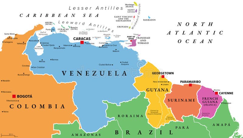
Free with trial Venezuela and The Guianas, multi colored political map. Geographical region in South America, consisting of the country Venezuela and The Guianas, which are Guyana, Suriname, and French Guiana. Vector. Windward vectors Venezuela and The Guianas, multi colored political map. Geographical region in South America, consisting of the country Venezuela and The Guianas, which are
Free with trial Venezuela and The Guianas, gray political map. Geographical region in north-eastern South America, consisting of the country Venezuela and The Guianas, which is Guyana, Suriname, and French Guiana. Windward vectors Venezuela and The Guianas, gray political map. Geographical region in north-eastern South America, consisting of the country Venezuela and The Guianas, which
Free with trial Map of Saint Vincent Island, Saint Vincent and the Grenadines. Windward vectors Map of Saint Vincent Island, Saint Vincent and the Grenadines.
Free with trial Map of Carriacou Island, Grenadine Islands, Grenada. Windward vectors Map of Carriacou Island, Grenadine Islands, Grenada.
Free with trial Venezuela and The Guianas, multi colored political map. Geographical region in north-eastern South America, consisting of Venezuela and The three Guianas Guyana, Suriname, and French Guiana. Vector. Windward vectors Venezuela and The Guianas, multi colored political map. Geographical region in north-eastern South America, consisting of Venezuela and The three Guianas
 Sign in