Free with trial Belgium map designed in illustration with the regions colored in bright colors and with the main cities. Neighbouring countries are in an additional format (. AI) in the latent layer. Belgian regions vectors Map of Belgium. Belgium map designed in illustration with the regions colored in bright colors and with the main cities. Neighbouring countries are in an additional format (. AI) in the latent layer.
Free with trial Belgium map designed in illustration with the regions colored in grey colors and with the main cities. Neighbouring countries are in an additional format (. AI) in the latent layer. Belgian regions vectors Belgium map
Free with trial Belgium map designed in illustration with the regions colored in bright colors and with the main cities. On an illustration neighbouring countries are shown too. Belgian regions vectors Belgium map
Free with trial A stylized map of Belgium showing the different provinces. All isolated on white background. Belgian regions illustrations Map Of Belgium
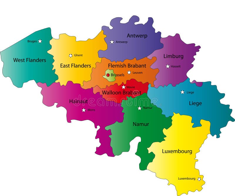
Free with trial Belgium map with administrative division into provinces. Brussels is the capital city, other cities are capitals of provinces. Belgian regions vectors Map of Belgium. Belgium map with administrative division into provinces. Brussels is the capital city, other cities are capitals of provinces.
Free with trial Outline of the map of Belgium with overview of relevant topics regarding Belgium. Belgian regions illustrations Belgium
Free with trial Highly detailed vector map of Belgium with administrative regions,main cities and roads. Belgian regions vectors Belgium map. Highly detailed vector map of Belgium with administrative regions,main cities and roads.
Free with trial Belgium set. Detailed country shape with region borders, flags and icons isolated on white background. Belgian regions vectors Belgium vector set. Belgium set. Detailed country shape with region borders, flags and icons isolated on white background.
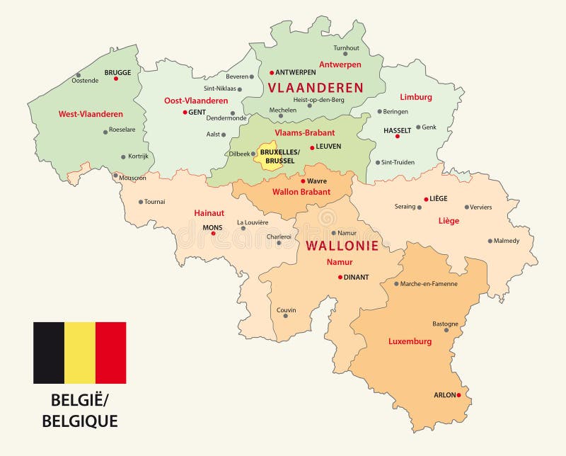
Free with trial Map of the Belgian regions and language areas. Belgian regions vectors Map of the Belgian regions and language areas
Free with trial Set Flags of the regions of Belgium, All Belgian provinces flag collection. Belgian regions illustrations Flags of the regions of Belgium, All Belgian provinces flag collection
Free with trial Brussels, Limburg and Antwerp Belgian regions vintage plates and travel stickers, vector. Belgium city tin signs and metal plates or luggage tags with Belgian heraldic elements and tourism sightseeing. Belgian regions vectors Brussels, Limburg, Antwerp Belgian regions plates. Brussels, Limburg and Antwerp Belgian regions vintage plates and travel stickers, vector. Belgium city tin signs and metal plates or luggage tags with Belgian heraldic elements and tourism sightseeing
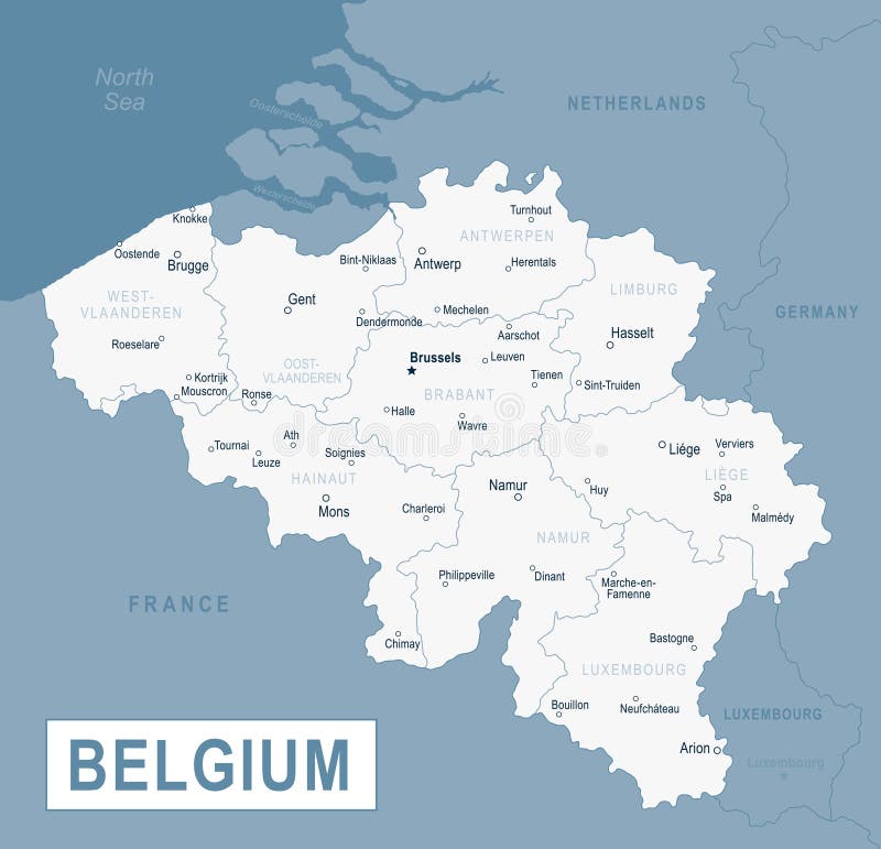
Free with trial Belgium map, individual regions and provinces with names vector. Belgian regions vectors Belgium map, individual regions and provinces with names
Free with trial Belgium map with regions illustrated. Belgian regions illustrations Belgium map with regions
Free with trial East and West Flanders or Flemish Brabant Belgian region vintage and travel stickers, vector. Belgium city tin signs and plates or luggage tags with Belgian heraldic symbols and tourism sightseeing. Belgian regions vectors Flanders, Flemish Brabant, Belgian regions plates. East and West Flanders or Flemish Brabant Belgian region vintage and travel stickers, vector. Belgium city tin signs and plates or luggage tags with Belgian heraldic symbols and tourism sightseeing
Free with trial Administrative vector map of the Belgian city Antwerp with flag. Belgian regions vectors Administrative vector map of the Belgian city Antwerp with flag
Free with trial Vector map of Belgium with the three regions Flemish, Wallonia and the capital Brussels in flag shape. Belgian regions vectors Vector map of Belgium with the three regions Flemish, Wallonia and the capital Brussels in flag shape
Free with trial All Flags of regions of Belgium. Vector illustraion. Belgian regions illustrations All Flags of regions Belgium. all Flags of regions of Belgium. Vector illustraion
Free with trial All Flags of regions of Belgium. Glossy button flag design. Belgian regions vectors All Flags of regions of Belgium template for your design. all Flags of regions of Belgium. Glossy button flag design
Free with trial Belgium region map: white outline on grey background. Detailed map of Belgium regions. Vector illustration. Belgian regions vectors Belgium region map: white outline on grey. Belgium region map: white outline on grey background. Detailed map of Belgium regions. Vector illustration.
Free with trial Vector map of Flemish Brabant region and location on Belgian map. Belgian regions vectors Map of Flemish Brabant, Belgium. Vector map of Flemish Brabant region and location on Belgian map
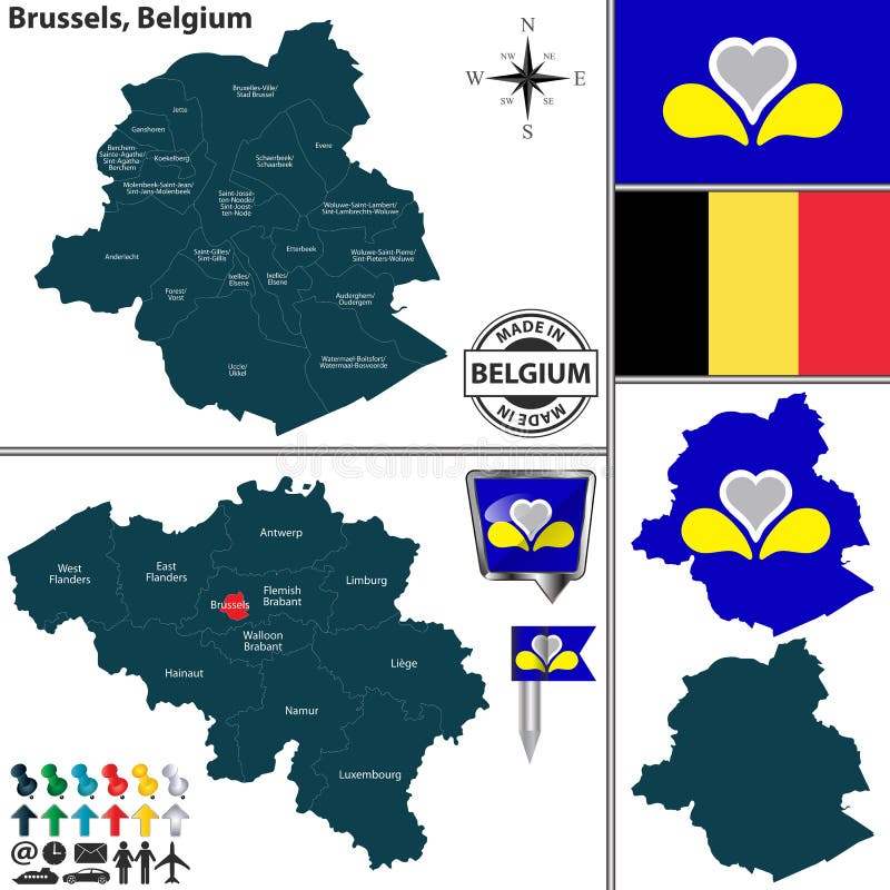
Free with trial Vector map of Brussels region and location on Belgian map. Belgian regions vectors Map of Brussels, Belgium. Vector map of Brussels region and location on Belgian map
Free with trial Vector map of East Flanders region and location on Belgian map. Belgian regions vectors Map of East Flanders, Belgium. Vector map of East Flanders region and location on Belgian map
Free with trial Belgium map infographic with Belgian cities Brussels Bruxelles, Liege Luik, Gent Ghent, Brugge Bruges, Charleroi, Antwerp Antwerpen with national flag yellow red. Belgian regions vectors Belgium infographic map city Brussels Bruxelles, Liege Luik, Gent Ghent, Brugge Bruges, Charleroi, Antwerp Antwerpen with national. Belgium map infographic with Belgian cities Brussels Bruxelles, Liege Luik, Gent Ghent, Brugge Bruges, Charleroi, Antwerp Antwerpen with national flag yellow red
Free with trial Belgium map with administrative division into provinces. Belgian regions vectors Belgium provinces map. Belgium map with administrative division into provinces.
Free with trial Belgium map in gray on a black background 3d. Belgian regions vectors Belgium map in gray on a black background 3d
Free with trial Belgium map, administrative division with names, white blue card paper 3D vector. Belgian regions vectors Belgium map, administrative division with names, white blue card paper 3D
Free with trial Belgium region map: grey outline on white background. Detailed map of Belgium regions. Vector illustration. Belgian regions vectors Belgium region map: grey outline on white. Belgium region map: grey outline on white background. Detailed map of Belgium regions. Vector illustration.
Free with trial Belgium breaking up in a Dutch-speaking and a French-speaking part because of the political turmoil of the last years?. Belgian regions illustrations Belgium breaking up?. Belgium breaking up in a Dutch-speaking and a French-speaking part because of the political turmoil of the last years?
Free with trial Vector set of Belgium country shape with flags, buttons and icons isolated on white background. Belgian regions vectors Belgium map. Vector set of Belgium country shape with flags, buttons and icons isolated on white background
Free with trial Belgium map with administrative division into provinces. Belgian regions vectors Belgium administrative map with flag. Belgium map with administrative division into provinces.
Free with trial Flag of Flemish Region is one of the three official regions of the Kingdom of Belgium. Vector illustration. Belgian regions vectors Flag of Flemish Region in Belgium. Flag of Flemish Region is one of the three official regions of the Kingdom of Belgium. Vector illustration
Free with trial Flag of East Flanders is a province of Flanders, one of the three regions of Belgium. Vector illustration. Belgian regions vectors Flag of East Flanders in Flemish Region of Belgium. Flag of East Flanders is a province of Flanders, one of the three regions of Belgium. Vector illustration
Free with trial The administrative map of East Flanders Province with labels, Belgium. Belgian regions vectors East Flanders administrative map. The administrative map of East Flanders Province with labels, Belgium
Free with trial This image is a detailed map of the Belgian regions isolated on a white background. It includes the regions Flanders, Wallonia, and the Brussels-Capital Region. The map is on a transparent background, making it suitable for various applications. Key features include distinct color coding for each region and a smaller inset map for reference. Belgian regions illustrations Map of belgian regions isolated on white background. This image is a detailed map of the Belgian regions isolated on a white background. It includes the regions Flanders, Wallonia, and the Brussels-Capital Region. The map is on a transparent background, making it suitable for various applications. Key features include distinct color coding for each region and a smaller inset map for reference
Free with trial This image is a map of the Belgian regions isolated on a white background. It displays the different regions of Belgium, including Flanders, Wallonia, and Brussels-Capital Region, each represented in distinct colors. The map provides a clear and visually distinct representation of the regions. Belgian regions illustrations Map of belgian regions isolated on white background. This image is a map of the Belgian regions isolated on a white background. It displays the different regions of Belgium, including Flanders, Wallonia, and Brussels-Capital Region, each represented in distinct colors. The map provides a clear and visually distinct representation of the regions
Free with trial This image is a map of the Belgian regions with a transparent background. It clearly shows the Flemish Region (Flanders), Walloon Region (Wallonia), Brussels-Capital Region, and Walloon Region (Walloons). The map is isolated on a white background, making the regions easily distinguishable. Belgian regions illustrations Map of belgian regions isolated on white background. This image is a map of the Belgian regions with a transparent background. It clearly shows the Flemish Region (Flanders), Walloon Region (Wallonia), Brussels-Capital Region, and Walloon Region (Walloons). The map is isolated on a white background, making the regions easily distinguishable
Free with trial Soar above the picturesque Belgian city of Sint-Michielshelling and discover the enchanting beauty of its cobblestone streets and historic architecture. This breathtaking aerial view captures the intricate network of Sint-Michielshelling Street, showcasing the charming houses and shops nestled amongst the ancient structures. The iconic St. Michael's Bridge, a testament to the region's rich. Belgian regions illustrations Stunning Aerial Perspective of SintMichielshelling Street and St Michaels Bridge A Charming Belgian Cityscape Unveiled. Soar above the picturesque Belgian city of Sint-Michielshelling and discover the enchanting beauty of its cobblestone streets and historic architecture. This breathtaking aerial view captures the intricate network of Sint-Michielshelling Street, showcasing the charming houses and shops nestled amongst the ancient structures. The iconic St. Michael's Bridge, a testament to the region's rich
Free with trial Belgium Map. Detailed Vector Illustration of Belgian Map. Stock Template. Belgian regions vectors Belgium Map. Detailed Vector Illustration of Belgian Map
Free with trial Explore the intricate geography of Belgium with this stunning, detailed blue map. Perfect for students, researchers, and anyone interested in Belgian geography, this map meticulously showcases the country administrative divisions. Observe the precise boundaries of each county, region, and state, providing a clear overview of Belgium political structure. The vibrant blue color palette enhances. Belgian regions illustrations A Comprehensive and Detailed Blue Map of Belgium Visualizing Counties Regions and States with Precision for Geography. Explore the intricate geography of Belgium with this stunning, detailed blue map. Perfect for students, researchers, and anyone interested in Belgian geography, this map meticulously showcases the country administrative divisions. Observe the precise boundaries of each county, region, and state, providing a clear overview of Belgium political structure. The vibrant blue color palette enhances
Free with trial Belgium - detailed country map with cities and regions. Infographic icons. Vector illustration. Belgian regions illustrations Belgium - detailed country map with cities and regions. Infographic icons
Free with trial A highly detailed and vibrant 3D rendering of the map of Belgium, clearly showcasing its distinct administrative regions in a spectrum of engaging colors. This professional graphic provides an excellent visual representation for geographical studies, educational content, travel planning, or business presentations focused on Belgium. The three-dimensional perspective adds depth and visual appeal, making it an ideal asset for illustrating territorial divisions and national overview. Perfect for conveying complex regional information with clarity and style. Belgian regions illustrations Vibrant 3D Belgium Map showcasing Administrative Good Resolution Stock Photo. A highly detailed and vibrant 3D rendering of the map of Belgium, clearly showcasing its distinct administrative regions in a spectrum of engaging colors. This professional graphic provides an excellent visual representation for geographical studies, educational content, travel planning, or business presentations focused on Belgium. The three-dimensional perspective adds depth and visual appeal, making it an ideal asset for illustrating territorial divisions and national overview. Perfect for conveying complex regional information with clarity and style.
Free with trial Step back in time as you explore the captivating architectural gems of Leuven's historic old town in Belgium. This image showcases the exquisite beauty of meticulously preserved brick buildings, a testament to the region's rich history and architectural heritage. The intricate details, from the meticulously crafted facades to the charmingly aged textures, paint a vivid picture of the town's. Belgian regions illustrations Discover the Architectural Beauty of Leuvens Historic Old Town Stunning Brick Buildings Capture the Charm of Belgium. Step back in time as you explore the captivating architectural gems of Leuven's historic old town in Belgium. This image showcases the exquisite beauty of meticulously preserved brick buildings, a testament to the region's rich history and architectural heritage. The intricate details, from the meticulously crafted facades to the charmingly aged textures, paint a vivid picture of the town's
Free with trial Unleash your creativity with this stunning vintage-style map of Belgium. Presented in a classic black chalkboard design, this detailed political map showcases the country's regions with an antique and distressed aesthetic. Perfect for a variety of projects, this blank template is ideal for filling in your own information, adding labels, or using as a beautiful backdrop. The meticulously crafted. Belgian regions illustrations Detailed Vintage Belgium Map Blank Chalkboard Style for Design Education. Unleash your creativity with this stunning vintage-style map of Belgium. Presented in a classic black chalkboard design, this detailed political map showcases the country's regions with an antique and distressed aesthetic. Perfect for a variety of projects, this blank template is ideal for filling in your own information, adding labels, or using as a beautiful backdrop. The meticulously crafted
Free with trial Immerse yourself in the captivating beauty of Hainaut Province, Belgium, with this stunning panoramic map. The detailed imagery showcases the intricate network of roads, rivers, and towns, offering a comprehensive overview of the region. Ideal for geography enthusiasts, students, or anyone interested in exploring the cultural and historical tapestry of this Belgian region. The grayscale palette. Belgian regions illustrations Hainaut Province Belgium Map A Panoramic Exploration of the Regions Rich History and Landscape on a Gray Background. Immerse yourself in the captivating beauty of Hainaut Province, Belgium, with this stunning panoramic map. The detailed imagery showcases the intricate network of roads, rivers, and towns, offering a comprehensive overview of the region. Ideal for geography enthusiasts, students, or anyone interested in exploring the cultural and historical tapestry of this Belgian region. The grayscale palette
Free with trial Four representations of Belgium: a map with the national flag, a black silhouette, a detailed outline with regions, and a simple outline. Belgian regions vectors Belgium map with flag and outlines. Four representations of Belgium: a map with the national flag, a black silhouette, a detailed outline with regions, and a simple outline
Free with trial Step back in time as you explore the captivating architectural gems of Leuven's historic old town in Belgium. This image showcases the exquisite beauty of meticulously preserved brick buildings, a testament to the region's rich history and architectural heritage. The intricate details, from the meticulously crafted facades to the charmingly aged textures, paint a vivid picture of the town's. Belgian regions illustrations Discover the Architectural Beauty of Leuvens Historic Old Town Stunning Brick Buildings Capture the Charm of Belgium. Step back in time as you explore the captivating architectural gems of Leuven's historic old town in Belgium. This image showcases the exquisite beauty of meticulously preserved brick buildings, a testament to the region's rich history and architectural heritage. The intricate details, from the meticulously crafted facades to the charmingly aged textures, paint a vivid picture of the town's
Free with trial Map of Belgium with stylized regions and fictional names. Shows simplified locations of landmarks and Belgian flags indicating key areas. Regions outlined in different colors for distinction. Idealized icons of historical buildings and monuments scattered throughout. Main cities and areas labeled with imaginative names, not real geographic markers. The map serves as an illustrative, educational tool rather than an actual geographical representation. Belgian regions illustrations Map of Belgium with stylized regions and fictional names
Free with trial Belgium map Regions Isolated detailed Belgium Blue map with Regions and national borders map. Belgian regions vectors Belgium map Regions Isolated detailed Belgium Blue map with Regions and national borders map.
Free with trial This comprehensive vector illustration showcases a detailed map of Belgium, highlighting city boundaries and administrative regions. The map features a clear delineation of major cities like Brussels, Antwerp, Ghent, and Liege, providing a precise geographic representation of the country. The national flag is subtly overlaid onto the map, adding a touch of national pride and readily identifying. Belgian regions illustrations Detailed Vector Map of Belgium Cities with Administrative Boundaries and National Flag Overlay Perfect for Travel. This comprehensive vector illustration showcases a detailed map of Belgium, highlighting city boundaries and administrative regions. The map features a clear delineation of major cities like Brussels, Antwerp, Ghent, and Liege, providing a precise geographic representation of the country. The national flag is subtly overlaid onto the map, adding a touch of national pride and readily identifying
Free with trial Map of Belgium and the Netherlands with inset of the surroundings of Antwerp. Publication of the "Meyers encyclopedia", Volume 6, Leipzig, Germany, 1910. Belgian regions illustrations Map of Belgium and the Netherlands with inset of the surroundings of Antwerp.
Free with trial Belgium political map of administrative divisions - provinces. Grey blank vector editable map EPS. Belgian regions vectors Belgium editable vector political map EPS. Belgium political map of administrative divisions - provinces. Grey blank vector editable map EPS.
Free with trial Blank map Province Liege of Belgium. High quality map Liege with municipalities on transparent background for your web site design, logo, app, UI. EPS10. Belgian regions vectors Blank map Province Liege of Belgium. High quality map Liege with municipalities on transparent background
Free with trial Blank map Province Hainaut of Belgium. High quality map Hainaut with municipalities on transparent background for your web site design, logo, app, UI. EPS10. Belgian regions vectors Blank map Province Hainaut of Belgium. High quality map Hainaut with municipalities on transparent background
Free with trial High Quality map Namur is a city of Belgium, with borders of the districts. Map of Namur for your web site design, app, UI. EPS10. Belgian regions vectors High Quality map Namur is a city of Belgium, with borders of the districts. Map of Namur
Free with trial Blank map Province Walloon Brabant of Belgium. High quality map Walloon Brabant with municipalities on transparent background for your web site design, logo, app, UI. EPS10. Belgian regions vectors Blank map Province Walloon Brabant of Belgium. High quality map Walloon Brabant with municipalities
Free with trial Blank map Province Limburg of Belgium. High quality map Limburg with municipalities on transparent background for your web site design, logo, app, UI. EPS10. Belgian regions vectors Blank map Province Limburg of Belgium. High quality map Limburg with municipalities on transparent background
Free with trial Blank map Province East Flanders of Belgium. High quality map East Flanders with municipalities on transparent background for your web site design, logo, app, UI. EPS10. Belgian regions vectors Blank map Province East Flanders of Belgium. High quality map East Flanders with municipalities on transparent background
Free with trial Blank map Province Flemish Brabant of Belgium. High quality map Flemish Brabant with municipalities on transparent background for your web site design, logo, app, UI. EPS10. Belgian regions vectors Blank map Province Flemish Brabant of Belgium. High quality map Flemish Brabant with municipalities on transparent background
Free with trial This is a High-resolution vector map. Clean line art, black & white silhouette - Ideal for travel & tourism projects. Fully scalable and print ready format. Belgian regions vectors Belgium Map Vector Illustration - Silhouette, Outline, Belgium Travel and Tourism Map. This is a High-resolution vector map. Clean line art, black & white silhouette - Ideal for travel & tourism projects. Fully scalable and print ready format.
Free with trial The administrative map of East Flanders Province isolated on white background, Belgium. Belgian regions vectors East Flanders administrative map. The administrative map of East Flanders Province isolated on white background, Belgium
Free with trial This image depicts a stylized map of Belgium with a focus on the Wallonia region, colored in black, yellow, and red to resemble the Belgian national flag. The design highlights the distinct cultural and linguistic division within the country, showing Wallonia in black and yellow, while the neighboring Flemish region is depicted in red. This artistic representation emphasizes the unique identity of. Belgian regions illustrations Flag-inspired map of the region of wallonia and its neighboring regions in belgium. This image depicts a stylized map of Belgium with a focus on the Wallonia. This image depicts a stylized map of Belgium with a focus on the Wallonia region, colored in black, yellow, and red to resemble the Belgian national flag. The design highlights the distinct cultural and linguistic division within the country, showing Wallonia in black and yellow, while the neighboring Flemish region is depicted in red. This artistic representation emphasizes the unique identity of
Free with trial Belgium Map Vector Vintage Dark Blue Beige - Customizable layered political map of Belgium with administrative divisions for website, education, reports, news, politics, print, poster and wallpaper. Belgian regions vectors Belgium Map Vector Vintage Dark Blue Beige - Customizable layered political map of Belgium with administrative divisions for
Free with trial Belgium Map Vector Blue Spot - Customizable layered political map of Belgium with administrative divisions for website, education, reports, news, politics, print, poster and wallpaper. Belgian regions vectors Belgium Map Vector Blue Spot - Customizable layered political map of Belgium with administrative divisions for website, education
Free with trial This meticulously crafted map of Belgium showcases the country's intricate geography in stunning detail. The high-quality imagery allows for precise identification of major cities, towns, and natural features, such as rivers, forests, and mountains. This detailed representation is ideal for students, researchers, and anyone interested in exploring the Belgian landscape. The inclusion of the. Belgian regions illustrations Detailed Belgium Map with National Flag A Comprehensive Geographic Representation for Study and Reference. This meticulously crafted map of Belgium showcases the country's intricate geography in stunning detail. The high-quality imagery allows for precise identification of major cities, towns, and natural features, such as rivers, forests, and mountains. This detailed representation is ideal for students, researchers, and anyone interested in exploring the Belgian landscape. The inclusion of the
Free with trial This meticulously detailed map of Belgium showcases the country's geographical boundaries, including its bordering nations. The vibrant Belgian flag is prominently featured, adding a touch of national pride to the visual representation. The map's clarity and precision make it an invaluable tool for various applications. Students can utilize it for geography studies, referencing key cities and. Belgian regions illustrations Detailed Map of Belgium with Flag Icon HighQuality Stock Image for Geographic Studies Travel Planning and Educational. This meticulously detailed map of Belgium showcases the country's geographical boundaries, including its bordering nations. The vibrant Belgian flag is prominently featured, adding a touch of national pride to the visual representation. The map's clarity and precision make it an invaluable tool for various applications. Students can utilize it for geography studies, referencing key cities and
Free with trial Belgium Map Vector New 2024 Colorful - Customizable layered political map of Belgium with administrative divisions for website, education, reports, news, politics, print, poster and wallpaper. Belgian regions vectors Belgium Map Vector New 2024 Colorful - Customizable layered political map of Belgium with administrative divisions for website
Free with trial Belgian low poly regions. Polygonal map of Belgium with regions. Geometric maps for your design. Radiant vector illustration. Belgian regions vectors Belgian low poly regions.
Free with trial Map of Belgium administrative regions departments with icons. Map location pin, arrow, looking glass, signboard, man, bicycle, car, airplane, house, church. Royalty free outline Belgian vector map. Belgian regions vectors Map of Belgium administrative regions departments, icons. Map location pin, arrow, man, bicycle, car, airplane. Map of Belgium administrative regions departments with icons. Map location pin, arrow, looking glass, signboard, man, bicycle, car, airplane, house, church. Royalty free outline Belgian vector map
Free with trial Brussels, Limburg and Antwerp Belgian regions vintage plates and travel stickers, vector. Belgium city tin signs and metal plates or luggage tags with Belgian heraldic elements and tourism sightseeing. Belgian regions vectors Brussels, Limburg, Antwerp Belgian regions plates. Brussels, Limburg and Antwerp Belgian regions vintage plates and travel stickers, vector. Belgium city tin signs and metal plates or luggage tags with Belgian heraldic elements and tourism sightseeing
Free with trial Belgium map, individual regions and provinces blank template. Belgian regions vectors Belgium map, individual regions and provinces blank
Free with trial Belgium map Provinces of Belgium separates regions and names color map isolated on white background vector. Belgian regions vectors Belgium map Provinces of Belgium separates regions and names color map isolated on white background
Free with trial Belgium map, administrative division, separate individual regions with names, color map isolated on white background vector. Belgian regions vectors Belgium map, administrative division, separate individual regions with names, color map isolated on white background
Free with trial Belgium map. Cities regions Vector illustration. Belgian regions illustrations Belgium map. Cities, regions. Vector. Belgium map. Cities regions Vector illustration
Free with trial Belgium map, individual regions, provinces of Belgium, isolated on white background blank template. Belgian regions vectors Belgium map, individual regions, provinces of Belgium, isolated on white background blank
Free with trial Belgium map, administrative division, separates regions and names individual region, card paper 3D natural vector. Belgian regions vectors Belgium map, administrative division, separates regions and names individual region, card paper 3D natural
Free with trial Belgium map, administrative division, separates regions, card paper 3D natural blank template. Belgian regions vectors Belgium map, administrative division, separates regions, card paper 3D natural blank
Free with trial Infographics Belgium map, flat design colors, individual regions, blue background blank template. Belgian regions vectors Infographics Belgium map, flat design colors, individual regions, blue background blank
Free with trial Belgium map, administrative divisions whit names regions, blue background vector. Belgian regions vectors Belgium map, administrative divisions whit names regions, blue background
Free with trial Belgium map, Infographics flat design colors snow white, individual regions blank template. Belgian regions vectors Belgium map, Infographics flat design colors snow white, individual regions blank