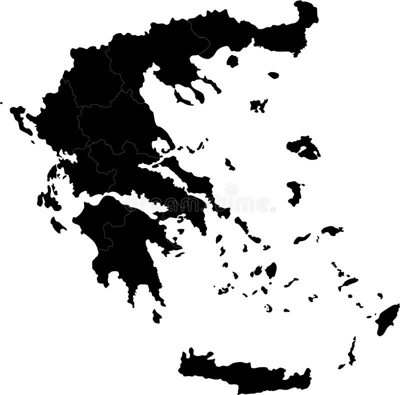
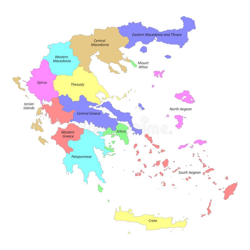
Free with trial Blind map of Greece with regions borders. Names of the regions, main cities, and neighbouring countries are in an additional format (. AI) in the latent layer. Boundary greece vectors Greece
Free with trial Greece vector map silhouette illustration. Boundary greece vectors GREECE MAP. Greece vector map silhouette illustration
Free with trial Greece map designed in illustration with the regions colored in green colors and with the main cities. Neighbouring countries are in an additional format (. AI) in the latent layer. Boundary greece vectors Map of Greece. Greece map designed in illustration with the regions colored in green colors and with the main cities. Neighbouring countries are in an additional format (.AI) in the latent layer.
Free with trial Greece map designed in illustration with the regions colored in bright colors and with the main cities. Neighbouring countries are in an additional format (. AI) in the latent layer. Boundary greece vectors Vector Greece map. Greece map designed in illustration with the regions colored in bright colors and with the main cities. Neighbouring countries are in an additional format (.AI) in the latent layer.
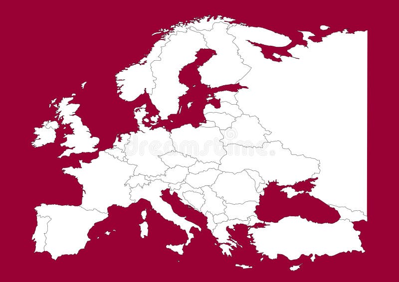
Free with trial This is a Europe map, Vector map - size and color can be changed for additional format! Great for your editorial article, news repport and other media!. Boundary greece vectors Europe vectorial map on red. This is a Europe map, Vector map - size and color can be changed for additional format! Great for your editorial article, news repport and other media!
Free with trial Greece map and boundaries on gradient background. Boundary greece vectors Greece map. Greece map and boundaries on gradient background.
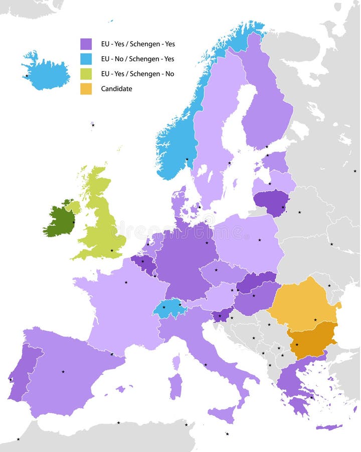
Free with trial Boundary of Schengen Area, Europe with countries silhouettes. Eps file contains separate layers with county name, boundaries and layer with counties. Boundary greece vectors Boundary of Schengen Area, Europe
Free with trial Greece map filled with light blue gradient. High resolution. Mercator projection. Boundary greece illustrations Greece map
Free with trial Greece set. Detailed country shape with region borders, flags and icons isolated on white background. Boundary greece vectors Greece set.
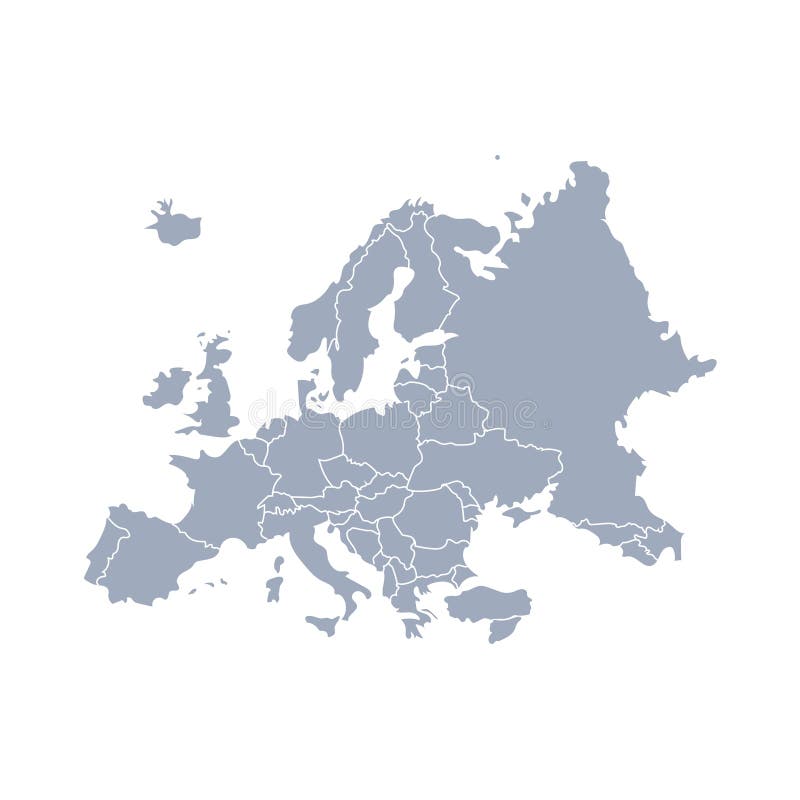
Free with trial Two europe maps: one soft coloured in light blue and one with colorful countries. Eps available. Boundary greece vectors Europe map
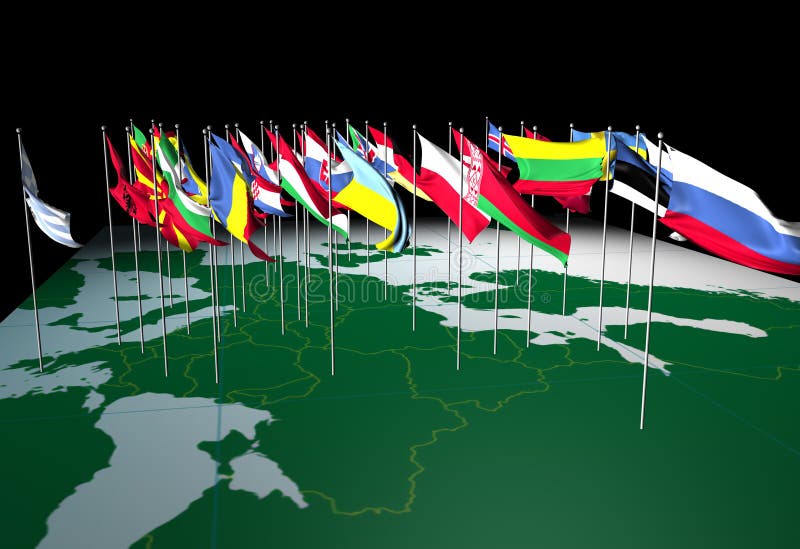
Free with trial Flags of European countries flying from their capital cities. Viewed from the South. Boundary greece illustrations European Flags on Map (South view). Flags of European countries flying from their capital cities. Viewed from the South.
Free with trial Flags of European countries flying from their capital cities. Viewed from the East. Boundary greece illustrations European Flags on Map (East view). Flags of European countries flying from their capital cities. Viewed from the East.
Free with trial Greece light blue map with shadow. High resolution. Mercator projection. Boundary greece illustrations Greece map. Greece light blue map with shadow. High resolution. Mercator projection.
Free with trial Highly detailed planet Earth. Night with glowing lights of the city gives way to day. The boundary of the night & day. Italy, Greece and the Mediterranean Sea. Elements of this image furnished by NASA. Boundary greece illustrations Detailed Earth. Italy, Greece and the Mediterranean Sea. Highly detailed planet Earth. Night with glowing lights of the city gives way to day. The boundary of the night & day. Italy, Greece and the Mediterranean Sea. Elements of this image furnished by NASA
Free with trial Colour Greece map with cities and regions on a white background. Boundary greece vectors Greece map on a white background. Colour Greece map with cities and regions on a white background
Free with trial Greece vector set with country shape, flags and symbols on white background. Boundary greece vectors Greece map. Greece vector set with country shape, flags and symbols on white background
Free with trial World map europe outline in vector, vector on white. Boundary greece illustrations World map europe outline in vector
Free with trial Greece, historically also known as Hellas, is a country in Southern Europe. Boundary greece vectors Map of Greece. Greece, historically also known as Hellas, is a country in Southern Europe
Free with trial Map of administrative divisions of Greece. Boundary greece illustrations Map of Greece. Map of administrative divisions of Greece
Free with trial Greece map in black on a background crumpled paper. Boundary greece vectors Greece map in black on a background crumpled paper
Free with trial Map of administrative divisions of Greece. Boundary greece illustrations Map of Greece. Map of administrative divisions of Greece
Free with trial Vector cartoon Greece map icon in comic style. Greece sign illustration pictogram. Cartography map business splash effect concept. Boundary greece vectors Vector cartoon Greece map icon in comic style. Greece sign illus
Free with trial Greece map icon. Business concept Greece pictogram. Vector illustration on green background. Boundary greece vectors Greece map icon. Business concept Greece pictogram. Vector
Free with trial High quality colorful labeled map of Greece with borders of the regions. Boundary greece illustrations High quality labeled map of Greece with borders of the regions
Free with trial Vector map Greece. Isolated vector Illustration. Black on White background. EPS 10 Illustration. Boundary greece illustrations Vector map Greece. Isolated vector Illustration. Black on White background
Free with trial White Greece map on gray background, vector, illustration, eps 10 file. Boundary greece vectors White Greece map on gray background, vector
Free with trial Grey political map of Greece. Administrative divisions - decentralized administrations. Simple flat blank vector map with labels. Boundary greece vectors Greece - map of decentralized administrations. Grey political map of Greece. Administrative divisions - decentralized administrations. Simple flat blank vector map with labels.
Free with trial Political map of Greece. Administrative divisions - decentralized administrations. Simple flat black outline vector map with labels. Boundary greece vectors Greece - map of decentralized administrations. Political map of Greece. Administrative divisions - decentralized administrations. Simple flat black outline vector map with labels.
Free with trial Stencil map of Greece. Simple and minimal transparent map of Greece. Black rectangle with cut shape of the country. Astonishing vector illustration. Boundary greece vectors Stencil map of Greece.
Free with trial Colorful political map of Greece. Administrative divisions - decentralized administrations. Simple flat vector map with labels. Boundary greece vectors Greece - map of decentralized administrations. Colorful political map of Greece. Administrative divisions - decentralized administrations. Simple flat vector map with labels.
Free with trial Kavala city (Greece, Hellenic Republic, Eastern Macedonia and Thrace region) map vector illustration, scribble sketch Kavala map. Boundary greece vectors Kavala city (Greece, Hellenic Republic, Eastern Macedonia and Thrace region) map vector illustration
Free with trial Map of Greece in a heart on the background of the flag. Boundary greece illustrations Map of Greece
Free with trial Vector map of Greece with named regions and travel icons. Boundary greece vectors Map of Greece with named regions
Free with trial Greece Map and National Flag Vector Digital Painting. Boundary greece vectors Greece Map and National Flag Vector
Free with trial Vector illustration of black silhouette Greece. Vector Greece map. Boundary greece vectors Vector illustration of black silhouette Greece. Vector map.
Free with trial Greece Map Flag. Map of Hellas with the Greek national flag isolated on white background. Vector Illustration. Boundary greece vectors Greece Map Flag. Map of Hellas with the Greek national flag isolated on white background. Vector Illustration
Free with trial Highly detailed map of Greece territory borders, South European country administrative map with Athens capital city and waving national flag vector illustration. Boundary greece vectors Highly detailed map of Greece territory borders
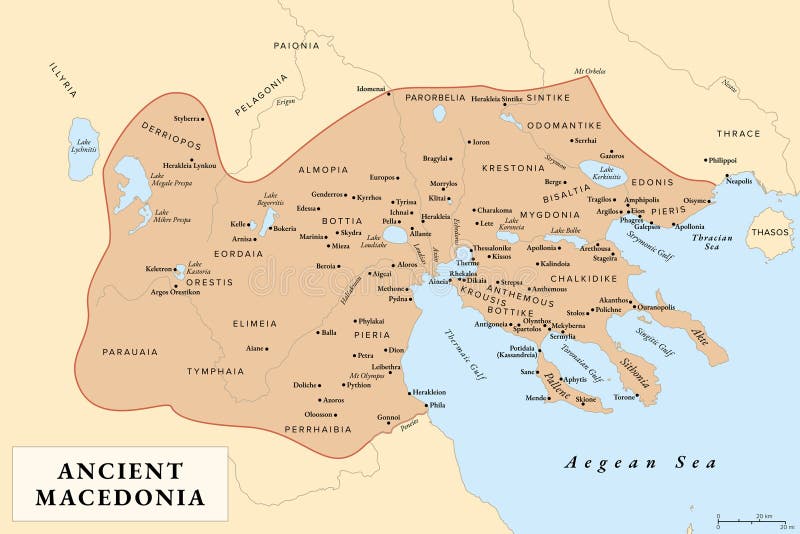
Free with trial Ancient Macedonia, Macedon, history map with approximate boundaries before Roman conquest. Kingdom on periphery of Archaic and Classical Greece which later become dominant state of Hellenistic Greece. Boundary greece vectors Ancient Macedonia, Macedon, history map
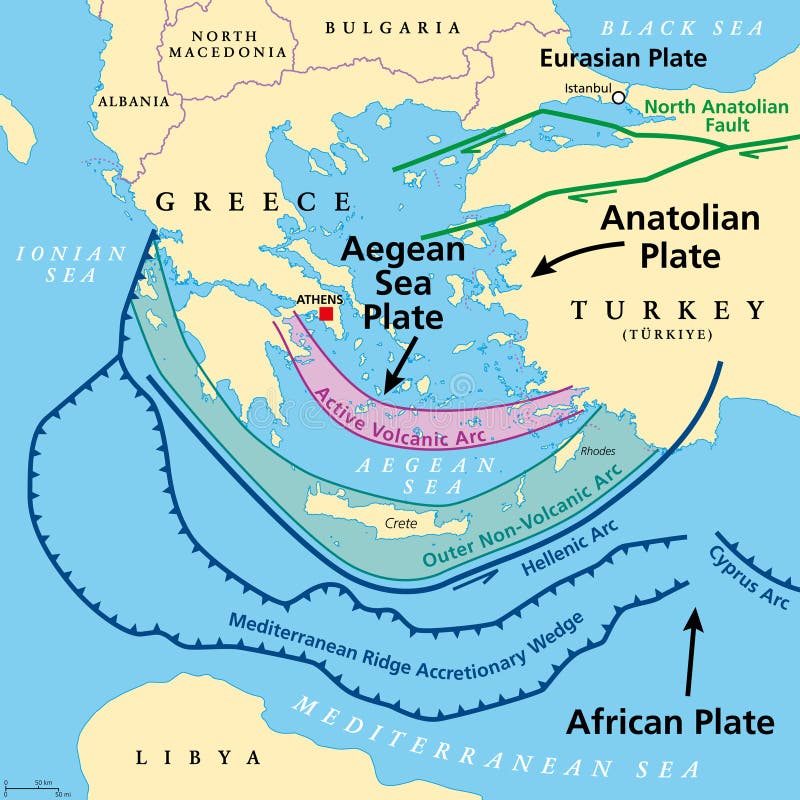
Free with trial Aegean Sea Plate and Hellenic Arc,tectonic map. Also called the Aegean or Hellenic Plate,is a small tectonic plate,located in the eastern Mediterranean Sea under southern Greece and western Turkey. Boundary greece vectors Aegean Sea Plate, also known as Aegean or Hellenic Plate, tectonic map. Aegean Sea Plate and Hellenic Arc,tectonic map. Also called the Aegean or Hellenic Plate,is a small tectonic plate,located in the eastern Mediterranean Sea under southern Greece and western Turkey.
Free with trial 3d map of Greece with borders of regions. Boundary greece illustrations 3d map with borders Template for your design. 3d map of Greece with borders of regions
Free with trial Illustration of euro currency symbol with europe maps. Boundary greece vectors Eurozone. Illustration of euro currency symbol with europe maps
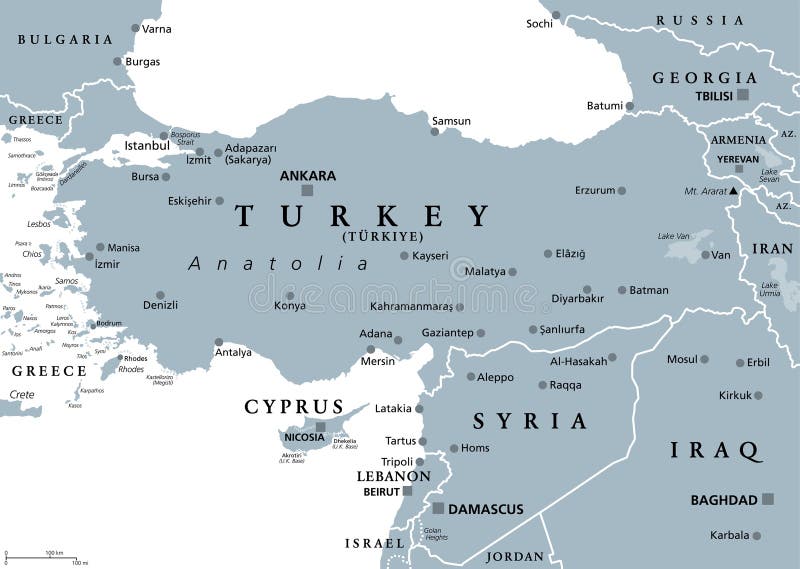
Free with trial Turkey and Syria region,gray political map. Geographic area of Anatolia,a peninsula and landmass making up most of the territory of contemporary Turkey,with neighbouring and surrounding countries. Boundary greece vectors Turkey and Syria region, geographic area of Anatolia, gray political map. Turkey and Syria region,gray political map. Geographic area of Anatolia,a peninsula and landmass making up most of the territory of contemporary Turkey,with neighbouring and surrounding countries.
Free with trial Illustration of euro currency symbol with europe maps. Boundary greece vectors Eurozone. Illustration of euro currency symbol with europe maps
Free with trial Anatolian Plate tectonics,gray map. Most of the country of Turkey is located on the Anatolian continental tectonic plate,separated from Eurasian and Arabian Plate by North and East Anatolian Fault. Boundary greece vectors Anatolian Plate tectonics, North and East Anatolian Fault, gray map. Anatolian Plate tectonics,gray map. Most of the country of Turkey is located on the Anatolian continental tectonic plate,separated from Eurasian and Arabian Plate by North and East Anatolian Fault.
Free with trial Illustration of euro currency symbol with europe maps. Boundary greece illustrations Eurozone. Illustration of euro currency symbol with europe maps
Free with trial Anatolian Plate tectonics map. Most of the country of Turkey is located on this continental tectonic plate,that is separated from the Eurasian and Arabian Plate by the North and East Anatolian Fault. Boundary greece vectors Anatolian Plate map, separated from the Eurasian and Arabian Plate. Anatolian Plate tectonics map. Most of the country of Turkey is located on this continental tectonic plate,that is separated from the Eurasian and Arabian Plate by the North and East Anatolian Fault.
Free with trial World map. graphic vector of europe map, vector on white. Boundary greece vectors World map. graphic vector of europe map
Free with trial World map europe outline in vector, vector. Boundary greece vectors World map europe outline in vector
Free with trial Hydra map. Island silhouette icon. Isolated Hydra black map outline. Vector illustration. Boundary greece vectors Hydra map.
Free with trial Rhodes map. Island silhouette icon. Isolated Rhodes black map outline. Vector illustration. Boundary greece vectors Rhodes map.
Free with trial World map europe outline in vector, vector. Boundary greece illustrations World map europe outline in vector
Free with trial Mykonos map. Blank vector map of the Island. Borders of Mykonos for your infographic. Vector illustration. Boundary greece vectors Mykonos map.
Free with trial Zakynthos Island map. Blank vector map of the Island. Borders of Zakynthos Island for your infographic. Vector illustration. Boundary greece vectors Zakynthos Island map.
Free with trial World map. graphic vector of latin america map. Boundary greece vectors World map. graphic vector of latin america map
Free with trial World map. graphic vector of latin america map. Boundary greece vectors World map. graphic vector of latin america map
Free with trial Rhodos blank outline map set. Boundary greece vectors Rhodos outline map. Rhodos blank outline map set
Free with trial Paros map. Island silhouette icon. Isolated Paros black map outline. Vector illustration. Boundary greece vectors Paros map.
Free with trial Zakynthos Island map. Island silhouette icon. Isolated Zakynthos Island black map outline. Vector illustration. Boundary greece vectors Zakynthos Island map.
Free with trial Paros badge. Map of the island with beautiful geometric waves and vibrant red blue frame. Vivid round Paros logo. Vector illustration. Boundary greece vectors Paros badge.
Free with trial The Bulgaria map divided in regions with some of the main cities. Boundary greece illustrations Bulgaria regions map. The Bulgaria map divided in regions with some of the main cities
Free with trial Kastellorizo map. Blank vector map of the Island. Borders of Kastellorizo for your infographic. Vector illustration. Boundary greece vectors Kastellorizo map.
Free with trial Ghana Country Map. Black silhouette and outline isolated on white background. EPS Vector. Boundary greece vectors Ghana Country Map. Black silhouette and outline isolated on white background. EPS Vector
Free with trial Crete vintage map. Grunge map of the island with distressed texture. Crete poster. Vector illustration. Boundary greece vectors Crete vintage map.
Free with trial Santorini badge. Bright gradient logo of island in low poly style. Multicolored Santorini rounded sign with map in geometric style for your infographics. Boundary greece vectors Santorini badge.
Free with trial Kos round stamp. Round logo with island map and title. Stylish minimal Kos badge with map. Vector illustration. Boundary greece vectors Kos round stamp.
Free with trial Kos low poly sunburst set. Logo of island in geometric polygonal style. Vector illustration. Boundary greece vectors Kos low poly sunburst set.
Free with trial Blossoming flower garden near the cottage. Spring flower bed. Vibrant and colourful farmer's flower garden. High quality illustration. Boundary greece illustrations Blossoming flower garden near the cottage. Spring flower bed
Free with trial Flags of European countries flying from their capital cities. Viewed from the North. Boundary greece illustrations European Flags on Map (North view). Flags of European countries flying from their capital cities. Viewed from the North.
Free with trial European union. EU. Set of flat design country map and national flag of member with shadow. White isolated background. Vector. Boundary greece vectors European union . EU . Set of flat design country map and national flag of member with shadow . White isolated background . Vector
Free with trial Patmos Logo. Map of Patmos with island name and flag. Appealing vector illustration. Boundary greece vectors Patmos Logo. Map of Patmos with island name and. Patmos Logo. Map of Patmos with island name and flag. Appealing vector illustration.
Free with trial Greece political map of administrative divisions - decentralized administrations and autonomous monastic state of Mount Athos. Colorful isometric blank vector map. Boundary greece vectors Greece political map of administrative divisions
Free with trial Greece political map of administrative divisions - decentralized administrations and autonomous monastic state of Mount Athos. Rainbow spectrum colorful blank vector map. Boundary greece vectors Greece political map of administrative divisions
Free with trial Greece political map of administrative divisions - decentralized administrations and autonomous monastic state of Mount Athos. Colorful handdrawn doodle style map with black outline borders and name labels. Boundary greece vectors Greece political map of administrative divisions. Decentralized administrations and autonomous monastic state of Mount Athos. Colorful handdrawn doodle style. Greece political map of administrative divisions - decentralized administrations and autonomous monastic state of Mount Athos. Colorful handdrawn doodle style map with black outline borders and name labels.
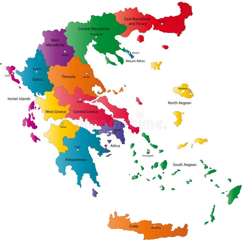
Free with trial Illustration of a detailed map of Greece. Colorful Map of Greece with all states and country boundaries. Boundary greece vectors Detailed Map Of Greece - Vector Illustration. Illustration of a detailed map of Greece. Colorful Map of Greece with all states and country boundaries.
Free with trial Greece political map of administrative divisions - decentralized administrations and autonomous monastic state of Mount Athos. Grey blank vector editable map EPS. Boundary greece vectors Greece editable vector political map EPS. Greece political map of administrative divisions - decentralized administrations and autonomous monastic state of Mount Athos. Grey blank vector editable map EPS.
Free with trial This image illustrates the black outline of the Greece map, with its country geographical shape and borders. Vector clipart illustration design using ai tool. Boundary greece vectors Greece silhouette. This image illustrates the black outline of the Greece map, with its country geographical shape and borders. Vector clipart illustration design using ai tool.
Free with trial West Greece (Greece) blank outline map set. Boundary greece vectors West Greece outline map. West Greece (Greece) blank outline map set