Free with trial Minnesota counties, gray political map. Minnesota, a state in the Upper Midwestern region of the United States, subdivided into 87 counties. Map with boundaries and county names. Illustration. Vector. Itasca county vectors U.S. state of Minnesota, subdivided into 87 counties, gray political map. Minnesota counties, gray political map. Minnesota, a state in the Upper Midwestern region of the United States, subdivided into 87 counties. Map with boundaries and county names. Illustration. Vector
Free with trial Rendering of a green 3d highway sign for Itasca County. Itasca county illustrations Road sign for Itasca County. Rendering of a green 3d highway sign for Itasca County
Free with trial Detailed and accurate illustration of map of Itasca in Minnesota. Itasca county vectors Map of Itasca in Minnesota
Free with trial Map of the County Itasca (Minnesota, US) showing the County with a few black dots. Itasca county illustrations Map of the County Itasca (Minnesota, United States). Map of the County Itasca (Minnesota, US) showing the County with a few black dots
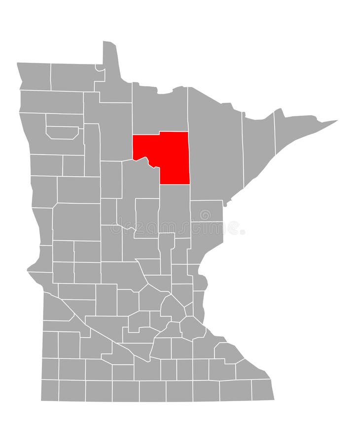
Free with trial Map of itasca County in Minnesota state on white background. single County map highlighted by black colour on Minnesota map. UNITED STATES, US. Itasca county illustrations Map of itasca County in Minnesota state on white background. single County map highlighted by black colour on Minnesota map.
Free with trial Symbol Map of the County Itasca (Minnesota, US) showing the County with a few black horizontal lines. Itasca county vectors Map of the County Itasca (Minnesota, United States). Symbol Map of the County Itasca (Minnesota, US) showing the County with a few black horizontal lines
Free with trial Map of the County Itasca (Minnesota, US) showing the isolated County with relief representation. No Lables. Itasca county illustrations Map of the County Itasca (Minnesota, United States). Map of the County Itasca (Minnesota, US) showing the isolated County with relief representation. No Lables. Map of the County Itasca (Minnesota, US) showing the isolated County with relief representation. No Lables.
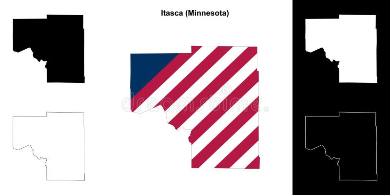
Free with trial Itasca County (Minnesota) outline map set. Itasca county vectors Itasca outline map. Itasca County (Minnesota) outline map set
Free with trial Itasca County (Minnesota) blank outline map. Itasca county vectors Itasca outline map. Itasca County (Minnesota) blank outline map
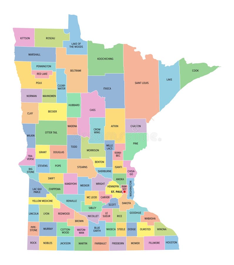
Free with trial Minnesota, U. S. state, subdivided into 87 counties, multi colored political map with capital St. Paul, borders and county names. State in the Upper Midwestern region of the USA. North Star State. Itasca county vectors Minnesota, U.S. state, subdivided into 87 counties, multi colored map. Minnesota, U.S. state, subdivided into 87 counties, multi colored political map with capital St. Paul, borders and county names. State in the Upper Midwestern region of the USA. North Star State.
Free with trial Minnesota counties, political map. Minnesota, a state in the Upper Midwestern region of the United States, is subdivided into 87 counties. Map with boundaries and county names. Illustration. Vector. Itasca county vectors U.S. state of Minnesota, subdivided into 87 counties, political map. Minnesota counties, political map. Minnesota, a state in the Upper Midwestern region of the United States, is subdivided into 87 counties. Map with boundaries and county names. Illustration. Vector
Free with trial Itasca County, Minnesota U. S. county, United States of America, USA, U. , US map vector illustration, scribble sketch Itasca map,. Itasca county vectors Itasca County, Minnesota U.S. county, United States of America, USA, U.S., US map vector illustration, scribble sketch Itasca
Free with trial Rendering of a green 3d highway sign for Itasca County. Itasca county illustrations Road sign for Itasca County. Rendering of a green 3d highway sign for Itasca County
Free with trial Rendering of a green 3d highway sign for Itasca County. Itasca county illustrations Road sign for Itasca County. Rendering of a green 3d highway sign for Itasca County
Free with trial Itasca County, Minnesota U. S. county, United States of America, USA, U. , US map vector illustration, scribble sketch Itasca map,. Itasca county vectors Itasca County, Minnesota U.S. county, United States of America, USA, U.S., US map vector illustration, scribble sketch Itasca
Free with trial Itasca County, Minnesota U. S. county, United States of America, USA, U. , US map vector illustration, scribble sketch Itasca map,. Itasca county vectors Itasca County, Minnesota U.S. county, United States of America, USA, U.S., US map vector illustration, scribble sketch Itasca
Free with trial Black highlighted location map of the Itasca County inside gray map of the Federal State of Minnesota, USA. Itasca county vectors Location map of the Itasca County of Minnesota, USA. Black highlighted location map of the Itasca County inside gray map of the Federal State of Minnesota, USA
Free with trial US Minnesota State Map with 87 counties and county seats. Each County is an individual object. Itasca county vectors Minnesota County Map with 87 counties. US Minnesota State Map with 87 counties and county seats. Each County is an individual object.
Free with trial Detailed and accurate illustration of map of Itasca in Minnesota. Itasca county vectors Map of Itasca in Minnesota
Free with trial Detailed and accurate illustration of map of Itasca in Minnesota. Itasca county vectors Map of Itasca in Minnesota
Free with trial Isolated US city limit sign of Grand Rapids, located in Itasca county, Minnesota. Place name sign from the USA on blue background. Itasca county illustrations Grand Rapids, Minnesota city limit sign. Town sign from the USA. Isolated US city limit sign of Grand Rapids, located in Itasca county, Minnesota. Place name sign from the USA on blue background