Free with trial Pacific tectonic plate on the physical elevation map in the Compact Miller projection centered meridionally. Boundaries of other plates. Pacific plate illustrations Pacific tectonic plate. Physical. Compact Miller. Boundaries. Pacific tectonic plate on the physical elevation map in the Compact Miller projection centered meridionally. Boundaries of other plates
Free with trial Pacific tectonic plate on the Blue Marble satellite map in the Natural Earth II projection centered meridionally. Locations of earthquakes above 6. 5 magnitude recorded since the early 17th century. Pacific plate illustrations Pacific tectonic plate. Satellite. Natural Earth II. Earthquakes. Pacific tectonic plate on the Blue Marble satellite map in the Natural Earth II projection centered meridionally. Locations of earthquakes above 6.5 magnitude recorded since the early 17th century
Free with trial Pacific tectonic plate on the solid contour map in the Lagrange Oblique projection centered meridionally and latitudinally. Locations of earthquakes above 6. 5 magnitude recorded since the early 17th century. Pacific plate illustrations Pacific tectonic plate. Contour. Lagrange Oblique. Earthquakes a. Pacific tectonic plate on the solid contour map in the Lagrange Oblique projection centered meridionally and latitudinally. Locations of earthquakes above 6.5 magnitude recorded since the early 17th century
Free with trial Pacific tectonic plate outlined on the globe. topographic map. 3D rendering. Pacific plate illustrations Pacific plate outlined - topographic. Pacific tectonic plate outlined on the globe. topographic map. 3D rendering
Free with trial Pacific tectonic plate on the solid contour map in the Natural Earth II projection centered meridionally. Boundaries of other plates. Pacific plate illustrations Pacific tectonic plate. Contour. Natural Earth II. Boundaries. Pacific tectonic plate on the solid contour map in the Natural Earth II projection centered meridionally. Boundaries of other plates
Free with trial Pacific tectonic plate on the Wiki style elevation map in the Times projection centered meridionally. Distribution of known volcanoes. Pacific plate illustrations Pacific tectonic plate. Wiki. Times. Volcanoes and boundaries. Pacific tectonic plate on the Wiki style elevation map in the Times projection centered. Pacific tectonic plate on the Wiki style elevation map in the Times projection centered meridionally. Distribution of known volcanoes
Free with trial Pacific tectonic plate on the bilevel elevation map in the Natural Earth II projection centered meridionally. Boundaries of other plates. Pacific plate illustrations Pacific tectonic plate. Bilevel. Natural Earth II. Boundaries. Pacific tectonic plate on the bilevel elevation map in the Natural Earth II projection centered meridionally. Boundaries of other plates
Free with trial Pacific tectonic plate on the solid contour map in the Lagrange Oblique projection centered meridionally and latitudinally. Boundaries of other plates. Pacific plate illustrations Pacific tectonic plate. Contour. Lagrange Oblique. Boundaries. Pacific tectonic plate on the solid contour map in the Lagrange Oblique projection centered meridionally and latitudinally. Boundaries of other plates
Free with trial Pacific tectonic plate on the Blue Marble satellite map in the Kavrayskiy VII projection centered meridionally. Boundaries of other plates. Pacific plate illustrations Pacific tectonic plate. Satellite. Kavrayskiy VII. Boundaries. Pacific tectonic plate on the Blue Marble satellite map in the Kavrayskiy VII projection centered meridionally. Boundaries of other plates
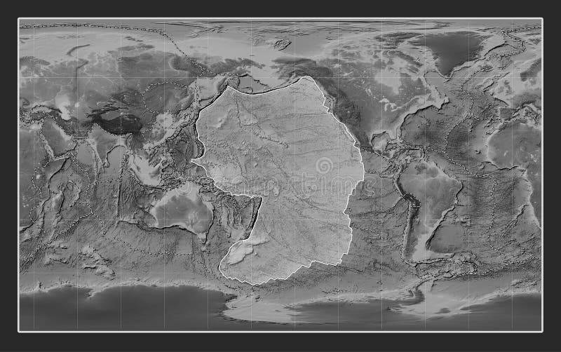
Free with trial Pacific tectonic plate on the grayscale elevation map in the Kavrayskiy VII projection centered meridionally. Boundaries of other plates. Pacific plate illustrations Pacific tectonic plate. Grayscale. Kavrayskiy VII. Boundaries. Pacific tectonic plate on the grayscale elevation map in the Kavrayskiy VII projection centered meridionally. Boundaries of other plates
Free with trial Pacific tectonic plate on the Wiki style elevation map in the Fahey projection centered meridionally. Distribution of known volcanoes. Pacific plate illustrations Pacific tectonic plate. Wiki. Fahey. Volcanoes and boundaries. Pacific tectonic plate on the Wiki style elevation map in the Fahey projection centered meridionally. Distribution of known volcanoes
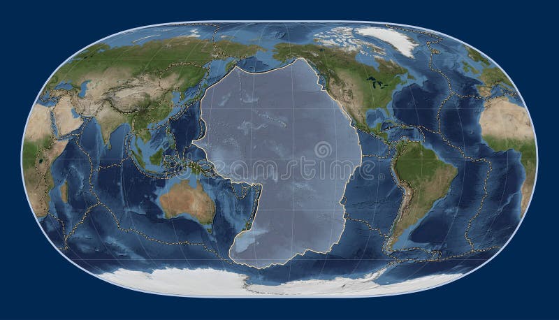
Free with trial Pacific tectonic plate on the Blue Marble satellite map in the Compact Miller projection centered meridionally. Boundaries of other plates. Pacific plate illustrations Pacific tectonic plate. Satellite. Compact Miller. Boundaries. Pacific tectonic plate on the Blue Marble satellite map in the Compact Miller projection centered meridionally. Boundaries of other plates
Free with trial Pacific tectonic plate on the grayscale elevation map in the Compact Miller projection centered meridionally. Boundaries of other plates. Pacific plate illustrations Pacific tectonic plate. Grayscale. Compact Miller. Boundaries. Pacific tectonic plate on the grayscale elevation map in the Compact Miller projection centered meridionally. Boundaries of other plates
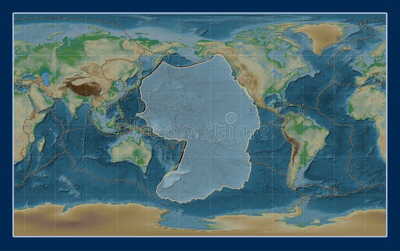
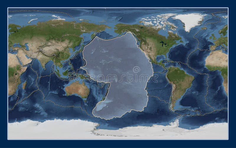
Free with trial Pacific tectonic plate on the physical elevation map in the Natural Earth II projection centered meridionally. Boundaries of other plates. Pacific plate illustrations Pacific tectonic plate. Physical. Natural Earth II. Boundaries. Pacific tectonic plate on the physical elevation map in the Natural Earth II projection centered meridionally. Boundaries of other plates
Free with trial Pacific tectonic plate overview the global shapes only - land/ocean mask in the Azimuthal Equidistant projection with dashed plates borders. 3D rendering. Pacific plate illustrations Pacific plate overview - solid. Pacific tectonic plate overview the global shapes only - land/ocean mask in the Azimuthal Equidistant projection with dashed plates borders. 3D rendering
Free with trial Pacific tectonic plate on the Wiki style elevation map in the Robinson projection centered meridionally. Boundaries of other plates. Pacific plate illustrations Pacific tectonic plate. Wiki. Robinson. Boundaries. Pacific tectonic plate on the Wiki style elevation map in the Robinson projection centered meridionally. Boundaries of other plates
Free with trial Pacific tectonic plate on the Wiki style elevation map in the Natural Earth II projection centered meridionally. Locations of earthquakes above 6. 5 magnitude recorded since the early 17th century. Pacific plate illustrations Pacific tectonic plate. Wiki. Natural Earth II. Earthquakes and. Pacific tectonic plate on the Wiki style elevation map in the Natural Earth II projection centered meridionally. Locations of earthquakes above 6.5 magnitude recorded since the early 17th century
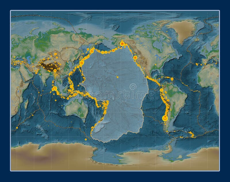
Free with trial Pacific tectonic plate on the physical elevation map in the Natural Earth II projection centered meridionally. Locations of earthquakes above 6. 5 magnitude recorded since the early 17th century. Pacific plate illustrations Pacific tectonic plate. Physical. Natural Earth II. Earthquakes. Pacific tectonic plate on the physical elevation map in the Natural Earth II projection centered meridionally. Locations of earthquakes above 6.5 magnitude recorded since the early 17th century
Free with trial Pacific tectonic plate on the Blue Marble satellite map in the Natural Earth II projection centered meridionally. Boundaries of other plates. Pacific plate illustrations Pacific tectonic plate. Satellite. Natural Earth II. Boundaries. Pacific tectonic plate on the Blue Marble satellite map in the Natural Earth II projection centered meridionally. Boundaries of other plates
Free with trial Pacific tectonic plate on the grayscale elevation map in the Natural Earth II projection centered meridionally. Boundaries of other plates. Pacific plate illustrations Pacific tectonic plate. Grayscale. Natural Earth II. Boundaries. Pacific tectonic plate on the grayscale elevation map in the Natural Earth II projection centered meridionally. Boundaries of other plates
Free with trial Pacific tectonic plate on the Wiki style elevation map in the Times projection centered meridionally. Locations of earthquakes above 6. 5 magnitude recorded since the early 17th century. Pacific plate illustrations Pacific tectonic plate. Wiki. Times. Earthquakes and boundaries. Pacific tectonic plate on the Wiki style elevation map in the Times projection centered meridionally. Locations of earthquakes above 6.5 magnitude recorded since the early 17th century
Free with trial Pacific tectonic plate on the solid contour map in the Times projection centered meridionally. Boundaries of other plates. Pacific plate illustrations Pacific tectonic plate. Contour. Times. Boundaries. Pacific tectonic plate on the solid contour map in the Times projection centered meridionally. Boundaries of other plates
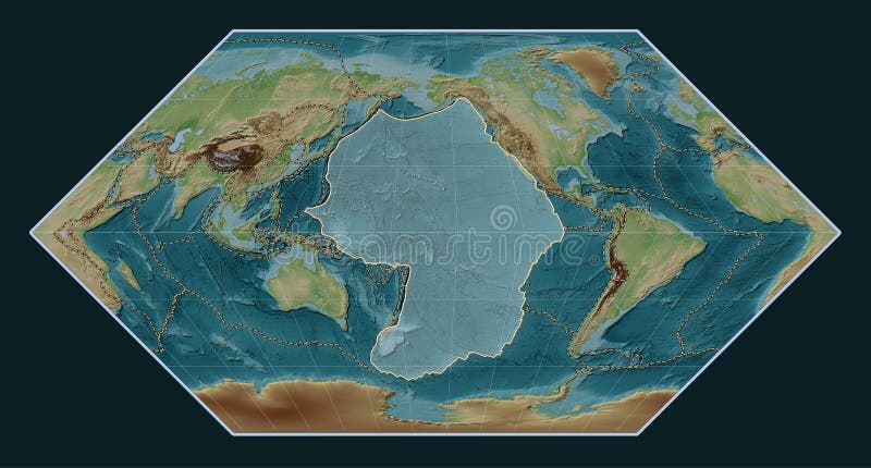
Free with trial Pacific tectonic plate on the physical elevation map in the Kavrayskiy VII projection centered meridionally. Distribution of known volcanoes. Pacific plate illustrations Pacific tectonic plate. Physical. Kavrayskiy VII. Volcanoes and. Pacific tectonic plate on the physical elevation map in the Kavrayskiy VII projection centered meridionally. Distribution of known volcanoes
Free with trial Pacific tectonic plate on the solid contour map in the Gall Stereographic projection centered meridionally. Boundaries of other plates. Pacific plate illustrations Pacific tectonic plate. Contour. Gall Stereographic. Boundaries. Pacific tectonic plate on the solid contour map in the Gall Stereographic projection centered meridionally. Boundaries of other plates
Free with trial Pacific tectonic plate on the physical elevation map in the Gall Stereographic projection centered meridionally. Distribution of known volcanoes. Pacific plate illustrations Pacific tectonic plate. Physical. Gall Stereographic. Volcanoes. Pacific tectonic plate on the physical elevation map in the Gall Stereographic projection centered meridionally. Distribution of known volcanoes
Free with trial Pacific tectonic plate on the bilevel elevation map in the Gall Stereographic projection centered meridionally. Boundaries of other plates. Pacific plate illustrations Pacific tectonic plate. Bilevel. Gall Stereographic. Boundaries. Pacific tectonic plate on the bilevel elevation map in the Gall Stereographic projection centered meridionally. Boundaries of other plates
Free with trial Pacific tectonic plate on the Wiki style elevation map in the Gall Stereographic projection centered meridionally. Distribution of known volcanoes. Pacific plate illustrations Pacific tectonic plate. Wiki. Gall Stereographic. Volcanoes and. Pacific tectonic plate on the Wiki style elevation map in the Gall Stereographic projection centered meridionally. Distribution of known volcanoes
Free with trial Pacific tectonic plate on the bilevel elevation map in the Fahey Oblique projection centered meridionally and latitudinally. Locations of earthquakes above 6. 5 magnitude recorded since the early 17th century. Pacific plate illustrations Pacific tectonic plate. Bilevel. Fahey Oblique. Earthquakes and. Pacific tectonic plate on the bilevel elevation map in the Fahey Oblique projection centered meridionally and latitudinally. Locations of earthquakes above 6.5 magnitude recorded since the early 17th century
Free with trial Pacific tectonic plate on the Wiki style elevation map in the Fahey projection centered meridionally. Locations of earthquakes above 6. 5 magnitude recorded since the early 17th century. Pacific plate illustrations Pacific tectonic plate. Wiki. Fahey. Earthquakes and boundaries. Pacific tectonic plate on the Wiki style elevation map in the Fahey projection centered meridionally. Locations of earthquakes above 6.5 magnitude recorded since the early 17th century
Free with trial Pacific tectonic plate on the solid contour map in the Fahey Oblique projection centered meridionally and latitudinally. Locations of earthquakes above 6. 5 magnitude recorded since the early 17th century. Pacific plate illustrations Pacific tectonic plate. Contour. Fahey Oblique. Earthquakes and. Pacific tectonic plate on the solid contour map in the Fahey Oblique projection centered meridionally and latitudinally. Locations of earthquakes above 6.5 magnitude recorded since the early 17th century
Free with trial Pacific tectonic plate on the Blue Marble satellite map in the Fahey Oblique projection centered meridionally and latitudinally. Distribution of known volcanoes. Pacific plate illustrations Pacific tectonic plate. Satellite. Fahey Oblique. Volcanoes and. Pacific tectonic plate on the Blue Marble satellite map in the Fahey Oblique projection centered meridionally and latitudinally. Distribution of known volcanoes
Free with trial Pacific tectonic plate on the bilevel elevation map in the Fahey projection centered meridionally. Boundaries of other plates. Pacific plate illustrations Pacific tectonic plate. Bilevel. Fahey. Boundaries. Pacific tectonic plate on the bilevel elevation map in the Fahey projection centered meridionally. Boundaries of other plates
Free with trial Pacific tectonic plate on the Wiki style elevation map in the Eckert I projection centered meridionally. Boundaries of other plates. Pacific plate illustrations Pacific tectonic plate. Wiki. Eckert I. Boundaries. Pacific tectonic plate on the Wiki style elevation map in the Eckert I projection centered meridionally. Boundaries of other plates
Free with trial Pacific tectonic plate on the physical elevation map in the Compact Miller projection centered meridionally. Distribution of known volcanoes. Pacific plate illustrations Pacific tectonic plate. Physical. Compact Miller. Volcanoes and. Pacific tectonic plate on the physical elevation map in the Compact Miller projection centered meridionally. Distribution of known volcanoes
Free with trial Pacific tectonic plate on the Blue Marble satellite map in the Times projection centered meridionally. Distribution of known volcanoes. Pacific plate illustrations Pacific tectonic plate. Satellite. Times. Volcanoes and boundari. Pacific tectonic plate on the Blue Marble satellite map in the Times projection centered meridionally. Distribution of known volcanoes
Free with trial Pacific tectonic plate on the physical elevation map in the Times projection centered meridionally. Distribution of known volcanoes. Pacific plate illustrations Pacific tectonic plate. Physical. Times. Volcanoes and boundarie. Pacific tectonic plate on the physical elevation map in the Times projection centered meridionally. Distribution of known volcanoes
Free with trial Pacific tectonic plate on the solid contour map in the Robinson projection centered meridionally. Distribution of known volcanoes. Pacific plate illustrations Pacific tectonic plate. Contour. Robinson. Volcanoes and boundar. Pacific tectonic plate on the solid contour map in the Robinson projection centered meridionally. Distribution of known volcanoes
Free with trial Pacific tectonic plate on the Blue Marble satellite map in the Robinson projection centered meridionally. Locations of earthquakes above 6. 5 magnitude recorded since the early 17th century. Pacific plate illustrations Pacific tectonic plate. Satellite. Robinson. Earthquakes and bou. Pacific tectonic plate on the Blue Marble satellite map in the Robinson projection centered meridionally. Locations of earthquakes above 6.5 magnitude recorded since the early 17th century
Free with trial Pacific tectonic plate on the Blue Marble satellite map in the Robinson projection centered meridionally. Distribution of known volcanoes. Pacific plate illustrations Pacific tectonic plate. Satellite. Robinson. Volcanoes and bound. Pacific tectonic plate on the Blue Marble satellite map in the Robinson projection centered meridionally. Distribution of known volcanoes
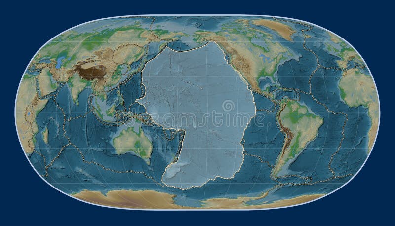
Free with trial Pacific tectonic plate on the physical elevation map in the Robinson projection centered meridionally. Distribution of known volcanoes. Pacific plate illustrations Pacific tectonic plate. Physical. Robinson. Volcanoes and bounda. Pacific tectonic plate on the physical elevation map in the Robinson projection centered meridionally. Distribution of known volcanoes
Free with trial Pacific tectonic plate on the solid contour map in the Natural Earth II projection centered meridionally. Distribution of known volcanoes. Pacific plate illustrations Pacific tectonic plate. Contour. Natural Earth II. Volcanoes and. Pacific tectonic plate on the solid contour map in the Natural Earth II projection centered meridionally. Distribution of known volcanoes
Free with trial Pacific tectonic plate on the solid contour map in the Robinson projection centered meridionally. Locations of earthquakes above 6. 5 magnitude recorded since the early 17th century. Pacific plate illustrations Pacific tectonic plate. Contour. Robinson. Earthquakes and bound. Pacific tectonic plate on the solid contour map in the Robinson projection centered meridionally. Locations of earthquakes above 6.5 magnitude recorded since the early 17th century
Free with trial Pacific tectonic plate on the physical elevation map in the Times projection centered meridionally. Locations of earthquakes above 6. 5 magnitude recorded since the early 17th century. Pacific plate illustrations Pacific tectonic plate. Physical. Times. Earthquakes and boundar. Pacific tectonic plate on the physical elevation map in the Times projection centered meridionally. Locations of earthquakes above 6.5 magnitude recorded since the early 17th century
Free with trial Pacific tectonic plate on the solid contour map in the Times projection centered meridionally. Locations of earthquakes above 6. 5 magnitude recorded since the early 17th century. Pacific plate illustrations Pacific tectonic plate. Contour. Times. Earthquakes and boundari. Pacific tectonic plate on the solid contour map in the Times projection centered meridionally. Locations of earthquakes above 6.5 magnitude recorded since the early 17th century
Free with trial Pacific tectonic plate on the bilevel elevation map in the Robinson projection centered meridionally. Locations of earthquakes above 6. 5 magnitude recorded since the early 17th century. Pacific plate illustrations Pacific tectonic plate. Bilevel. Robinson. Earthquakes and bound. Pacific tectonic plate on the bilevel elevation map in the Robinson projection centered meridionally. Locations of earthquakes above 6.5 magnitude recorded since the early 17th century
Free with trial Pacific tectonic plate on the Blue Marble satellite map in the Times projection centered meridionally. Locations of earthquakes above 6. 5 magnitude recorded since the early 17th century. Pacific plate illustrations Pacific tectonic plate. Satellite. Times. Earthquakes and bounda. Pacific tectonic plate on the Blue Marble satellite map in the Times projection centered meridionally. Locations of earthquakes above 6.5 magnitude recorded since the early 17th century
Free with trial Pacific tectonic plate on the grayscale elevation map in the Times projection centered meridionally. Locations of earthquakes above 6. 5 magnitude recorded since the early 17th century. Pacific plate illustrations Pacific tectonic plate. Grayscale. Times. Earthquakes and bounda. Pacific tectonic plate on the grayscale elevation map in the Times projection centered meridionally. Locations of earthquakes above 6.5 magnitude recorded since the early 17th century
Free with trial Pacific tectonic plate on the Wiki style elevation map in the Robinson projection centered meridionally. Locations of earthquakes above 6. 5 magnitude recorded since the early 17th century. Pacific plate illustrations Pacific tectonic plate. Wiki. Robinson. Earthquakes and boundari. Pacific tectonic plate on the Wiki style elevation map in the Robinson projection centered meridionally. Locations of earthquakes above 6.5 magnitude recorded since the early 17th century
Free with trial Pacific tectonic plate on the Wiki style elevation map in the Robinson projection centered meridionally. Distribution of known volcanoes. Pacific plate illustrations Pacific tectonic plate. Wiki. Robinson. Volcanoes and boundaries. Pacific tectonic plate on the Wiki style elevation map in the Robinson projection centered meridionally. Distribution of known volcanoes
Free with trial Pacific tectonic plate on the bilevel elevation map in the Times projection centered meridionally. Locations of earthquakes above 6. 5 magnitude recorded since the early 17th century. Pacific plate illustrations Pacific tectonic plate. Bilevel. Times. Earthquakes and boundari. Pacific tectonic plate on the bilevel elevation map in the Times projection centered meridionally. Locations of earthquakes above 6.5 magnitude recorded since the early 17th century
Free with trial Pacific tectonic plate on the grayscale elevation map in the Robinson projection centered meridionally. Locations of earthquakes above 6. 5 magnitude recorded since the early 17th century. Pacific plate illustrations Pacific tectonic plate. Grayscale. Robinson. Earthquakes and bou. Pacific tectonic plate on the grayscale elevation map in the Robinson projection centered meridionally. Locations of earthquakes above 6.5 magnitude recorded since the early 17th century
Free with trial Pacific tectonic plate on the solid contour map in the Times projection centered meridionally. Distribution of known volcanoes. Pacific plate illustrations Pacific tectonic plate. Contour. Times. Volcanoes and boundaries. Pacific tectonic plate on the solid contour map in the Times projection centered meridionally. Distribution of known volcanoes
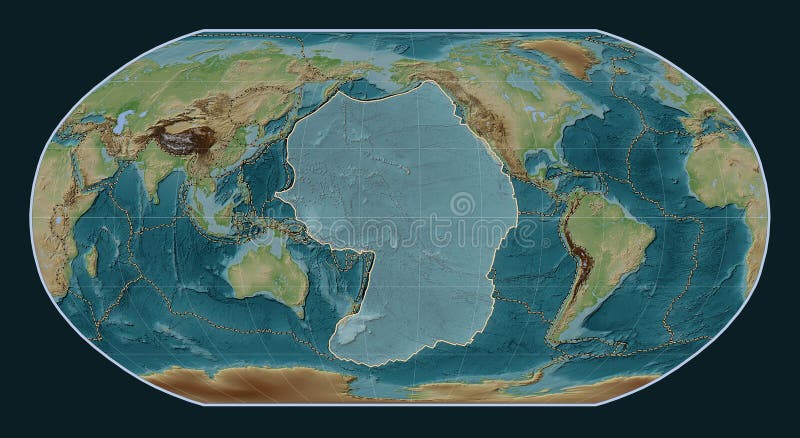
Free with trial Pacific tectonic plate on the physical elevation map in the Robinson projection centered meridionally. Locations of earthquakes above 6. 5 magnitude recorded since the early 17th century. Pacific plate illustrations Pacific tectonic plate. Physical. Robinson. Earthquakes and boun. Pacific tectonic plate on the physical elevation map in the Robinson projection centered meridionally. Locations of earthquakes above 6.5 magnitude recorded since the early 17th century
Free with trial Pacific tectonic plate on the solid contour map in the Natural Earth II projection centered meridionally. Locations of earthquakes above 6. 5 magnitude recorded since the early 17th century. Pacific plate illustrations Pacific tectonic plate. Contour. Natural Earth II. Earthquakes a. Pacific tectonic plate on the solid contour map in the Natural Earth II projection centered meridionally. Locations of earthquakes above 6.5 magnitude recorded since the early 17th century
Free with trial Pacific tectonic plate on the bilevel elevation map in the Natural Earth II projection centered meridionally. Locations of earthquakes above 6. 5 magnitude recorded since the early 17th century. Pacific plate illustrations Pacific tectonic plate. Bilevel. Natural Earth II. Earthquakes a. Pacific tectonic plate on the bilevel elevation map in the Natural Earth II projection centered meridionally. Locations of earthquakes above 6.5 magnitude recorded since the early 17th century
Free with trial Pacific tectonic plate on the physical elevation map in the Natural Earth II projection centered meridionally. Distribution of known volcanoes. Pacific plate illustrations Pacific tectonic plate. Physical. Natural Earth II. Volcanoes an. Pacific tectonic plate on the physical elevation map in the Natural Earth II projection centered meridionally. Distribution of known volcanoes
Free with trial Pacific tectonic plate on the Blue Marble satellite map in the Natural Earth II projection centered meridionally. Distribution of known volcanoes. Pacific plate illustrations Pacific tectonic plate. Satellite. Natural Earth II. Volcanoes a. Pacific tectonic plate on the Blue Marble satellite map in the Natural Earth II projection centered meridionally. Distribution of known volcanoes
Free with trial Pacific tectonic plate on the Wiki style elevation map in the Natural Earth II projection centered meridionally. Distribution of known volcanoes. Pacific plate illustrations Pacific tectonic plate. Wiki. Natural Earth II. Volcanoes and bo. Pacific tectonic plate on the Wiki style elevation map in the Natural Earth II projection centered meridionally. Distribution of known volcanoes
Free with trial Pacific tectonic plate on the grayscale elevation map in the Natural Earth II projection centered meridionally. Locations of earthquakes above 6. 5 magnitude recorded since the early 17th century. Pacific plate illustrations Pacific tectonic plate. Grayscale. Natural Earth II. Earthquakes. Pacific tectonic plate on the grayscale elevation map in the Natural Earth II projection centered meridionally. Locations of earthquakes above 6.5 magnitude recorded since the early 17th century
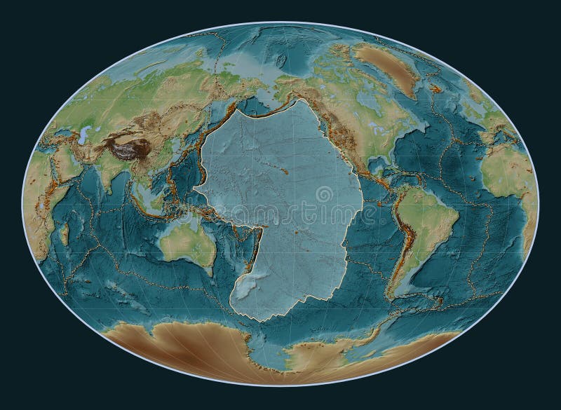
Free with trial Pacific tectonic plate on the physical elevation map in the Lagrange Oblique projection centered meridionally and latitudinally. Distribution of known volcanoes. Pacific plate illustrations Pacific tectonic plate. Physical. Lagrange Oblique. Volcanoes an. Pacific tectonic plate on the physical elevation map in the Lagrange Oblique projection centered meridionally and latitudinally. Distribution of known volcanoes
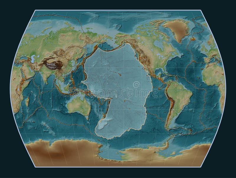
Free with trial Pacific tectonic plate on the physical elevation map in the Lagrange projection centered meridionally. Locations of earthquakes above 6. 5 magnitude recorded since the early 17th century. Pacific plate illustrations Pacific tectonic plate. Physical. Lagrange. Earthquakes and boun. Pacific tectonic plate on the physical elevation map in the Lagrange projection centered meridionally. Locations of earthquakes above 6.5 magnitude recorded since the early 17th century
Free with trial Pacific tectonic plate on the solid contour map in the Lagrange projection centered meridionally. Locations of earthquakes above 6. 5 magnitude recorded since the early 17th century. Pacific plate illustrations Pacific tectonic plate. Contour. Lagrange. Earthquakes and bound. Pacific tectonic plate on the solid contour map in the Lagrange projection centered meridionally. Locations of earthquakes above 6.5 magnitude recorded since the early 17th century
Free with trial Pacific tectonic plate on the Blue Marble satellite map in the Lagrange projection centered meridionally. Distribution of known volcanoes. Pacific plate illustrations Pacific tectonic plate. Satellite. Lagrange. Volcanoes and bound. Pacific tectonic plate on the Blue Marble satellite map in the Lagrange projection centered meridionally. Distribution of known volcanoes
Free with trial Pacific tectonic plate on the bilevel elevation map in the Lagrange projection centered meridionally. Locations of earthquakes above 6. 5 magnitude recorded since the early 17th century. Pacific plate illustrations Pacific tectonic plate. Bilevel. Lagrange. Earthquakes and bound. Pacific tectonic plate on the bilevel elevation map in the Lagrange projection centered meridionally. Locations of earthquakes above 6.5 magnitude recorded since the early 17th century
Free with trial Pacific tectonic plate on the physical elevation map in the Loximuthal projection centered meridionally. Locations of earthquakes above 6. 5 magnitude recorded since the early 17th century. Pacific plate illustrations Pacific tectonic plate. Physical. Loximuthal. Earthquakes and bo. Pacific tectonic plate on the physical elevation map in the Loximuthal projection centered meridionally. Locations of earthquakes above 6.5 magnitude recorded since the early 17th century
Free with trial Pacific tectonic plate on the Blue Marble satellite map in the Gall Stereographic projection centered meridionally. Boundaries of other plates. Pacific plate illustrations Pacific tectonic plate. Satellite. Gall Stereographic. Boundarie. Pacific tectonic plate on the Blue Marble satellite map in the Gall Stereographic projection centered meridionally. Boundaries of other plates
Free with trial Pacific tectonic plate on the grayscale elevation map in the Gall Stereographic projection centered meridionally. Boundaries of other plates. Pacific plate illustrations Pacific tectonic plate. Grayscale. Gall Stereographic. Boundarie. Pacific tectonic plate on the grayscale elevation map in the Gall Stereographic projection centered meridionally. Boundaries of other plates
Free with trial Pacific tectonic plate on the Blue Marble satellite map in the Gall Stereographic projection centered meridionally. Distribution of known volcanoes. Pacific plate illustrations Pacific tectonic plate. Satellite. Gall Stereographic. Volcanoes. Pacific tectonic plate on the Blue Marble satellite map in the Gall Stereographic projection centered meridionally. Distribution of known volcanoes
Free with trial Pacific tectonic plate on the Wiki style elevation map in the Kavrayskiy VII projection centered meridionally. Distribution of known volcanoes. Pacific plate illustrations Pacific tectonic plate. Wiki. Kavrayskiy VII. Volcanoes and boun. Pacific tectonic plate on the Wiki style elevation map in the Kavrayskiy VII projection centered meridionally. Distribution of known volcanoes
Free with trial Pacific tectonic plate on the solid contour map in the Kavrayskiy VII projection centered meridionally. Locations of earthquakes above 6. 5 magnitude recorded since the early 17th century. Pacific plate illustrations Pacific tectonic plate. Contour. Kavrayskiy VII. Earthquakes and. Pacific tectonic plate on the solid contour map in the Kavrayskiy VII projection centered meridionally. Locations of earthquakes above 6.5 magnitude recorded since the early 17th century
Free with trial Pacific tectonic plate on the physical elevation map in the Gall Stereographic projection centered meridionally. Locations of earthquakes above 6. 5 magnitude recorded since the early 17th century. Pacific plate illustrations Pacific tectonic plate. Physical. Gall Stereographic. Earthquake. Pacific tectonic plate on the physical elevation map in the Gall Stereographic projection centered meridionally. Locations of earthquakes above 6.5 magnitude recorded since the early 17th century
Free with trial Pacific tectonic plate on the Blue Marble satellite map in the Gall Stereographic projection centered meridionally. Locations of earthquakes above 6. 5 magnitude recorded since the early 17th century. Pacific plate illustrations Pacific tectonic plate. Satellite. Gall Stereographic. Earthquak. Pacific tectonic plate on the Blue Marble satellite map in the Gall Stereographic projection centered meridionally. Locations of earthquakes above 6.5 magnitude recorded since the early 17th century
Free with trial Pacific tectonic plate on the grayscale elevation map in the Gall Stereographic projection centered meridionally. Locations of earthquakes above 6. 5 magnitude recorded since the early 17th century. Pacific plate illustrations Pacific tectonic plate. Grayscale. Gall Stereographic. Earthquak. Pacific tectonic plate on the grayscale elevation map in the Gall Stereographic projection centered meridionally. Locations of earthquakes above 6.5 magnitude recorded since the early 17th century
Free with trial Pacific tectonic plate on the solid contour map in the Gall Stereographic projection centered meridionally. Locations of earthquakes above 6. 5 magnitude recorded since the early 17th century. Pacific plate illustrations Pacific tectonic plate. Contour. Gall Stereographic. Earthquakes. Pacific tectonic plate on the solid contour map in the Gall Stereographic projection centered meridionally. Locations of earthquakes above 6.5 magnitude recorded since the early 17th century
Free with trial Pacific tectonic plate on the physical elevation map in the Gall Stereographic projection centered meridionally. Boundaries of other plates. Pacific plate illustrations Pacific tectonic plate. Physical. Gall Stereographic. Boundaries. Pacific tectonic plate on the physical elevation map in the Gall Stereographic projection centered meridionally. Boundaries of other plates
Free with trial Pacific tectonic plate on the solid contour map in the Kavrayskiy VII projection centered meridionally. Distribution of known volcanoes. Pacific plate illustrations Pacific tectonic plate. Contour. Kavrayskiy VII. Volcanoes and b. Pacific tectonic plate on the solid contour map in the Kavrayskiy VII projection centered meridionally. Distribution of known volcanoes
Free with trial Pacific tectonic plate on the bilevel elevation map in the Kavrayskiy VII projection centered meridionally. Locations of earthquakes above 6. 5 magnitude recorded since the early 17th century. Pacific plate illustrations Pacific tectonic plate. Bilevel. Kavrayskiy VII. Earthquakes and. Pacific tectonic plate on the bilevel elevation map in the Kavrayskiy VII projection centered meridionally. Locations of earthquakes above 6.5 magnitude recorded since the early 17th century
Free with trial Pacific tectonic plate on the physical elevation map in the Kavrayskiy VII projection centered meridionally. Locations of earthquakes above 6. 5 magnitude recorded since the early 17th century. Pacific plate illustrations Pacific tectonic plate. Physical. Kavrayskiy VII. Earthquakes an. Pacific tectonic plate on the physical elevation map in the Kavrayskiy VII projection centered meridionally. Locations of earthquakes above 6.5 magnitude recorded since the early 17th century
Free with trial Pacific tectonic plate on the Wiki style elevation map in the Kavrayskiy VII projection centered meridionally. Locations of earthquakes above 6. 5 magnitude recorded since the early 17th century. Pacific plate illustrations Pacific tectonic plate. Wiki. Kavrayskiy VII. Earthquakes and bo. Pacific tectonic plate on the Wiki style elevation map in the Kavrayskiy VII projection centered meridionally. Locations of earthquakes above 6.5 magnitude recorded since the early 17th century
Free with trial Pacific tectonic plate on the Blue Marble satellite map in the Kavrayskiy VII projection centered meridionally. Distribution of known volcanoes. Pacific plate illustrations Pacific tectonic plate. Satellite. Kavrayskiy VII. Volcanoes and. Pacific tectonic plate on the Blue Marble satellite map in the Kavrayskiy VII projection centered meridionally. Distribution of known volcanoes