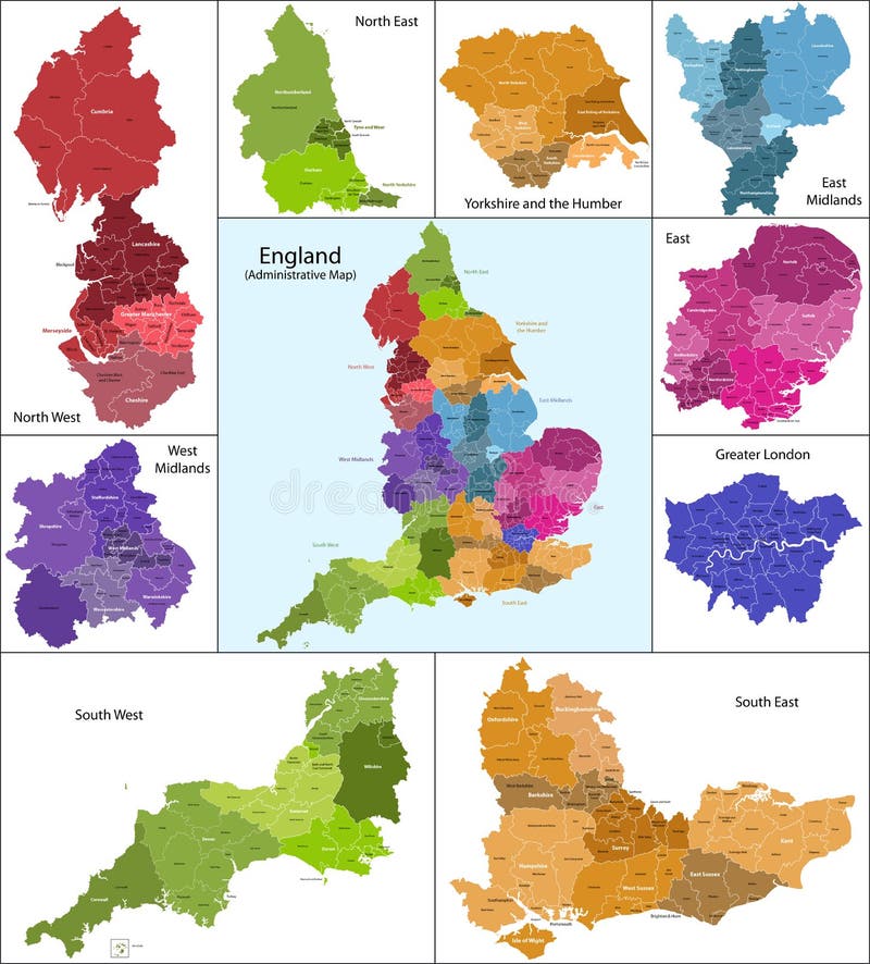
Free with trial The map shows the current subdivisions of England with a principal local authority: two-tier non-metropolitan counties and their non-metropolitan districts, metropolitan boroughs, unitary authorities, London boroughs and the sui generis City of London and Isles of Scilly. Principal areas vectors England map. The map shows the current subdivisions of England with a principal local authority: two-tier non-metropolitan counties and their non-metropolitan districts, metropolitan boroughs, unitary authorities, London boroughs and the sui generis City of London and Isles of Scilly
Free with trial Germany set. Detailed country shape with region borders, flags and icons isolated on white background. Principal areas vectors Germany vector set. Germany set. Detailed country shape with region borders, flags and icons isolated on white background.
Free with trial Detailed Old 1945 Map of Switzerland,including detail of major road and railway networks and mountain areas. Principal areas illustrations Old 1945 Map of Switzerland
Free with trial Vector map of Wales with principal areas and flags. Principal areas vectors Map of Wales with Principal Areas
Free with trial Labeled Color Map of Principal Areas of Wales. Principal areas vectors Map of Welsh Principal Areas. Labeled Color Map of Principal Areas of Wales
Free with trial White Labeled Flat Map of Council Areas of Scotland. Principal areas vectors Map of Scottish Council Areas. White Labeled Flat Map of Council Areas of Scotland
Free with trial Labeled Color Flat Map of Council Areas of Scotland. Principal areas vectors Map of Scottish Council Areas. Labeled Color Flat Map of Council Areas of Scotland
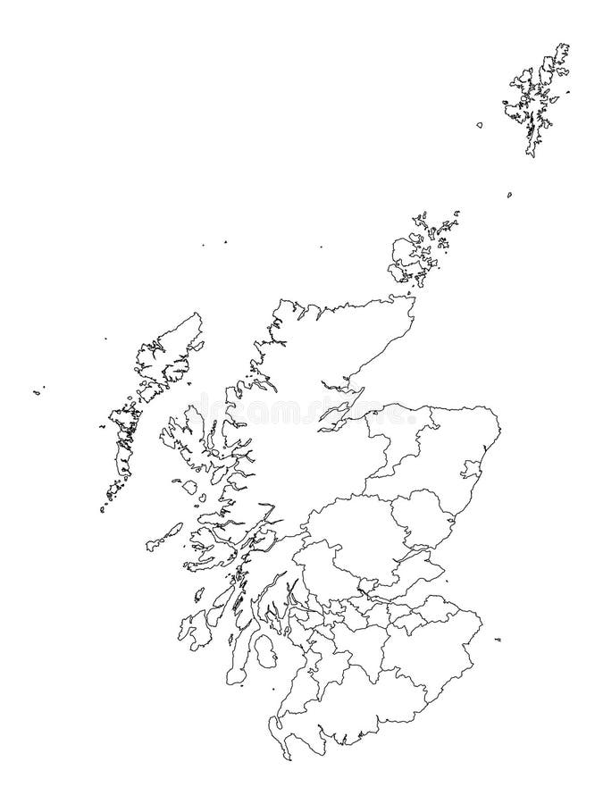
Free with trial White Flat Map of Council Areas of Scotland. Principal areas vectors Map of Scottish Council Areas. White Flat Map of Council Areas of Scotland
Free with trial Detailed Old 1945 Map of Netherlands, Holland,including detail of major road and railway networks. Inserts of North Sea Canal and Amsterdam. Principal areas illustrations Old 1945 Map of Netherlands or Holland. Detailed Old 1945 Map of Netherlands, Holland,including detail of major road and railway networks. Inserts of North Sea Canal and Amsterdam.
Free with trial Detailed Old 1945 Map of Saudi Arabia and Iran including detail of major road and railway networks. Principal areas illustrations Old 1945 Map of Saudi Arabia including Iran. Detailed Old 1945 Map of Saudi Arabia and Iran including detail of major road and railway networks.
Free with trial Detailed Old 1945 Map of Western Europe and North Africa ,including detail of major road and railway networks. Principal areas illustrations Old 1945 Map of Western Europe, including North Africa. Detailed Old 1945 Map of Western Europe and North Africa ,including detail of major road and railway networks.
Free with trial Detailed Old 1945 Map of Denmark and Faroe Islands,including detail of major road and railway networks. Inserts of North Sea Canal and Amsterdam. Principal areas illustrations Old 1945 Map of Faroe Islands and Denmark. Detailed Old 1945 Map of Denmark and Faroe Islands,including detail of major road and railway networks. Inserts of North Sea Canal and Amsterdam.
Free with trial Anglesey United Kingdom, Wales, Cymru, Principal areas of Wales map vector illustration, scribble sketch Isle of Anglesey map. Principal areas vectors Anglesey map vector. Anglesey United Kingdom, Wales, Cymru, Principal areas of Wales map vector illustration, scribble sketch Isle of Anglesey map
Free with trial Germany map and lands against white background, abstract vector art illustration. Principal areas vectors Germany map and lands
Free with trial Vector map of Scotland with named districts and icons. Principal areas vectors Map of Scotland with Districts. Vector map of Scotland with named districts and icons
Free with trial Vector map of Scotland with subdivisions and flags. Principal areas vectors Map of Scotland with Subdivisions
Free with trial Vector map of Northern Ireland with named districts. Principal areas vectors Map of Northern Ireland with Districts. Vector map of Northern Ireland with named districts
Free with trial Vector map of Northern Ireland with subdivisions and flags. Principal areas vectors Map of Northern Ireland with Subdivisions
Free with trial White Labeled Map of Districts of Northern Ireland, United Kingdom. Principal areas vectors Map of Northern Ireland Districts. White Labeled Map of Districts of Northern Ireland, United Kingdom
Free with trial Flag of the French Region of Hauts-de-France. Principal areas vectors Flag of Hauts-de-France. Flag of the French Region of Hauts-de-France
Free with trial Flag of the French Region of Pays de la Loire. Principal areas vectors Flag of Pays de la Loire. Flag of the French Region of Pays de la Loire
Free with trial Flag of the French Region of Centre-Val de Loire. Principal areas vectors Flag of Centre-Val de Loire. Flag of the French Region of Centre-Val de Loire
Free with trial Flag of the French Region of Provence-Alpes-Cote d`Azur. Principal areas vectors Flag of Provence-Alpes-Côte d`Azur. Flag of the French Region of Provence-Alpes-Cote d`Azur
Free with trial Flag of the French Region of Bretagne Brittany. Principal areas vectors Flag of Bretagne Brittany. Flag of the French Region of Bretagne Brittany
Free with trial Flag of the French Region of Normandie Normandy. Principal areas vectors Flag of Normandie Normandy. Flag of the French Region of Normandie Normandy
Free with trial Flag of the French Region of Bourgogne-Franche-Comte. Principal areas vectors Flag of Bourgogne-Franche-Comté. Flag of the French Region of Bourgogne-Franche-Comte
Free with trial Gray 3D Topography Map of European Country of Wales. Principal areas vectors Relief Map of Wales. Gray 3D Topography Map of European Country of Wales
Free with trial Regions of France Flags Set Collection. Principal areas vectors Set of French Regions` Flags. Regions of France Flags Set Collection
Free with trial Tactical Military Emerald 3D Topography Map of European Country of Northern Ireland, United Kingdom. Principal areas vectors Relief Map of of Northern Ireland. Tactical Military Emerald 3D Topography Map of European Country of Northern Ireland, United Kingdom
Free with trial Gray 3D Topography Map of European Country of Northern Ireland, United Kingdom. Principal areas vectors Relief Map of of Northern Ireland. Gray 3D Topography Map of European Country of Northern Ireland, United Kingdom
Free with trial Flag of the French Region of Grand Est Great East. Principal areas vectors Flag of Grand Est Great East. Flag of the French Region of Grand Est Great East
Free with trial Flag of the French Region of Nouvelle-Aquitaine. Principal areas vectors Flag of Nouvelle-Aquitaine. Flag of the French Region of Nouvelle-Aquitaine
Free with trial Flag of the French Region of Auvergne-Rhone-Alpes. Principal areas vectors Flag of Auvergne-Rhône-Alpes. Flag of the French Region of Auvergne-Rhone-Alpes
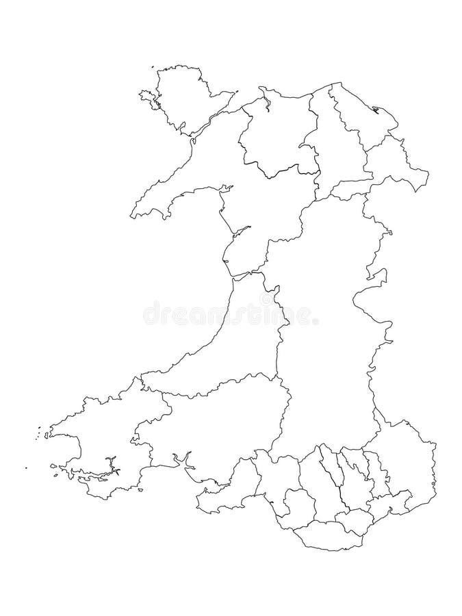
Free with trial White Flat Map of Principal Areas of Wales. Principal areas vectors Map of Welsh Principal Areas. White Flat Map of Principal Areas of Wales
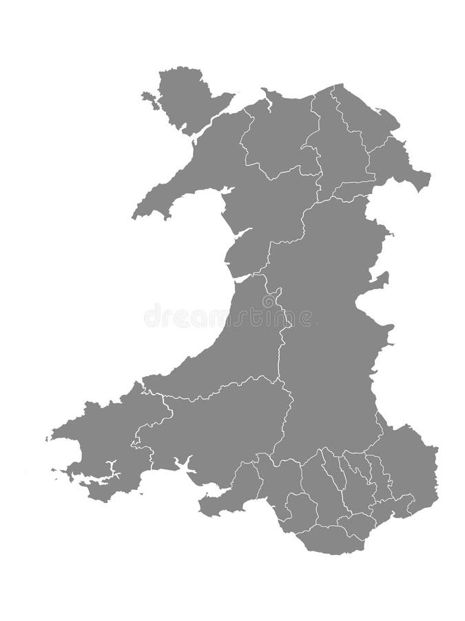
Free with trial Gray Flat Map of Principal Areas of Wales. Principal areas vectors Map of Welsh Principal Areas. Gray Flat Map of Principal Areas of Wales
Free with trial White Labeled Flat Map of Principal Areas of Wales. Principal areas vectors Map of Welsh Principal Areas. White Labeled Flat Map of Principal Areas of Wales
Free with trial Gray Flat Map of Council Areas of Scotland. Principal areas vectors Map of Scottish Council Areas. Gray Flat Map of Council Areas of Scotland
Free with trial The Bronze Age is a historic period, approximately 3300 BCE to 1200 BCE, that was characterized by the use of bronze, in some areas proto-writing, and other early features of urban civilization. The Bronze Age is the second principal period of the three-age Stone-Bronze-Iron system, as proposed in 1836 by Christian Jürgensen Thomsen, for classifying and studying ancient societies and history. Principal areas illustrations Bronze Age artefacts on display at the British Museum in London England. The Bronze Age is a historic period, approximately 3300 BCE to 1200 BCE, that was characterized by the use of bronze, in some areas proto-writing, and other early features of urban civilization. The Bronze Age is the second principal period of the three-age Stone-Bronze-Iron system, as proposed in 1836 by Christian Jürgensen Thomsen, for classifying and studying ancient societies and history.
Free with trial Core Knowledge traffic sign on blue sky background. Principal areas illustrations Core Knowledge traffic sign on blue sky
Free with trial Detailed Old 1945 Map of the Arctic Region,including detail of major road and railway networks. Principal areas illustrations Old 1945 Map of Arctic Regions, including Greenland. Detailed Old 1945 Map of the Arctic Region,including detail of major road and railway networks.
Free with trial Blaenau Gwent United Kingdom, Wales, Cymru, Principal areas of Wales map vector illustration, scribble sketch Blaenau Gwent County Borough map. Principal areas vectors Blaenau Gwent map vector. Blaenau Gwent United Kingdom, Wales, Cymru, Principal areas of Wales map vector illustration, scribble sketch Blaenau Gwent County Borough map
Free with trial Ceredigion United Kingdom, Wales, Cymru, Principal areas of Wales map vector illustration, scribble sketch Cardiganshire map. Principal areas vectors Ceredigion map vector. Ceredigion United Kingdom, Wales, Cymru, Principal areas of Wales map vector illustration, scribble sketch Cardiganshire map
Free with trial Cardiff United Kingdom, Wales, Cymru, Principal areas of Wales map vector illustration, scribble sketch City and County of Cardiff map. Principal areas vectors Cardiff map vector. Cardiff United Kingdom, Wales, Cymru, Principal areas of Wales map vector illustration, scribble sketch City and County of Cardiff map
Free with trial Anglesey United Kingdom, Wales, Cymru, Principal areas of Wales map vector illustration, scribble sketch Isle of Anglesey map. Principal areas vectors Anglesey map vector. Anglesey United Kingdom, Wales, Cymru, Principal areas of Wales map vector illustration, scribble sketch Isle of Anglesey map
Free with trial Vale of Glamorgan United Kingdom, Wales, Cymru, Principal areas of Wales map vector illustration, scribble sketch Vale of Glamorgan County Borough The Vale map. Principal areas vectors Vale of Glamorgan map vector. Vale of Glamorgan United Kingdom, Wales, Cymru, Principal areas of Wales map vector illustration, scribble sketch Vale of Glamorgan County Borough The Vale map
Free with trial Swansea Cynon Taf United Kingdom, Wales, Cymru, Principal areas of Wales map vector illustration, scribble sketch City and County of Swansea map. Principal areas vectors Swansea map vector. Swansea Cynon Taf United Kingdom, Wales, Cymru, Principal areas of Wales map vector illustration, scribble sketch City and County of Swansea map
Free with trial Pembrokeshire United Kingdom, Wales, Cymru, Principal areas of Wales map vector illustration, scribble sketch Pembrokeshire map. Principal areas vectors Pembrokeshire map vector. Pembrokeshire United Kingdom, Wales, Cymru, Principal areas of Wales map vector illustration, scribble sketch Pembrokeshire map
Free with trial Gwynedd United Kingdom, Wales, Cymru, Principal areas of Wales map vector illustration, scribble sketch Gwynedd map. Principal areas vectors Gwynedd map vector. Gwynedd United Kingdom, Wales, Cymru, Principal areas of Wales map vector illustration, scribble sketch Gwynedd map
Free with trial Powys United Kingdom, Wales, Cymru, Principal areas of Wales map vector illustration, scribble sketch County of Powys map. Principal areas vectors Powys map vector. Powys United Kingdom, Wales, Cymru, Principal areas of Wales map vector illustration, scribble sketch County of Powys map
Free with trial Powys United Kingdom, Wales, Cymru, Principal areas of Wales map vector illustration, scribble sketch County of Powys map. Principal areas vectors Powys map vector. Powys United Kingdom, Wales, Cymru, Principal areas of Wales map vector illustration, scribble sketch County of Powys map
Free with trial Powys United Kingdom, Wales, Cymru, Principal areas of Wales map vector illustration, scribble sketch County of Powys map. Principal areas vectors Powys map vector. Powys United Kingdom, Wales, Cymru, Principal areas of Wales map vector illustration, scribble sketch County of Powys map
Free with trial Swansea Cynon Taf United Kingdom, Wales, Cymru, Principal areas of Wales map vector illustration, scribble sketch City and County of Swansea map. Principal areas vectors Swansea map vector. Swansea Cynon Taf United Kingdom, Wales, Cymru, Principal areas of Wales map vector illustration, scribble sketch City and County of Swansea map
Free with trial Wrexham United Kingdom, Wales, Cymru, Principal areas of Wales map vector illustration, scribble sketch Wrexham County Borough map. Principal areas vectors Wrexham map vector. Wrexham United Kingdom, Wales, Cymru, Principal areas of Wales map vector illustration, scribble sketch Wrexham County Borough map
Free with trial Wrexham United Kingdom, Wales, Cymru, Principal areas of Wales map vector illustration, scribble sketch Wrexham County Borough map. Principal areas vectors Wrexham map vector. Wrexham United Kingdom, Wales, Cymru, Principal areas of Wales map vector illustration, scribble sketch Wrexham County Borough map
Free with trial Gwynedd United Kingdom, Wales, Cymru, Principal areas of Wales map vector illustration, scribble sketch Gwynedd map. Principal areas vectors Gwynedd map vector. Gwynedd United Kingdom, Wales, Cymru, Principal areas of Wales map vector illustration, scribble sketch Gwynedd map
Free with trial Cardiff United Kingdom, Wales, Cymru, Principal areas of Wales map vector illustration, scribble sketch City and County of Cardiff map. Principal areas vectors Cardiff map vector. Cardiff United Kingdom, Wales, Cymru, Principal areas of Wales map vector illustration, scribble sketch City and County of Cardiff map
Free with trial Torfaen United Kingdom, Wales, Cymru, Principal areas of Wales map vector illustration, scribble sketch Torfaen County Borough map. Principal areas vectors Torfaen map vector. Torfaen United Kingdom, Wales, Cymru, Principal areas of Wales map vector illustration, scribble sketch Torfaen County Borough map
Free with trial Gwynedd United Kingdom, Wales, Cymru, Principal areas of Wales map vector illustration, scribble sketch Gwynedd map. Principal areas vectors Gwynedd map vector. Gwynedd United Kingdom, Wales, Cymru, Principal areas of Wales map vector illustration, scribble sketch Gwynedd map
Free with trial Wrexham United Kingdom, Wales, Cymru, Principal areas of Wales map vector illustration, scribble sketch Wrexham County Borough map. Principal areas vectors Wrexham map vector. Wrexham United Kingdom, Wales, Cymru, Principal areas of Wales map vector illustration, scribble sketch Wrexham County Borough map
Free with trial Torfaen United Kingdom, Wales, Cymru, Principal areas of Wales map vector illustration, scribble sketch Torfaen County Borough map. Principal areas vectors Torfaen map vector. Torfaen United Kingdom, Wales, Cymru, Principal areas of Wales map vector illustration, scribble sketch Torfaen County Borough map
Free with trial Cardiff United Kingdom, Wales, Cymru, Principal areas of Wales map vector illustration, scribble sketch City and County of Cardiff map. Principal areas vectors Cardiff map vector. Cardiff United Kingdom, Wales, Cymru, Principal areas of Wales map vector illustration, scribble sketch City and County of Cardiff map
Free with trial Torfaen United Kingdom, Wales, Cymru, Principal areas of Wales map vector illustration, scribble sketch Torfaen County Borough map. Principal areas vectors Torfaen map vector. Torfaen United Kingdom, Wales, Cymru, Principal areas of Wales map vector illustration, scribble sketch Torfaen County Borough map
Free with trial Swansea Cynon Taf United Kingdom, Wales, Cymru, Principal areas of Wales map vector illustration, scribble sketch City and County of Swansea map. Principal areas vectors Swansea map vector. Swansea Cynon Taf United Kingdom, Wales, Cymru, Principal areas of Wales map vector illustration, scribble sketch City and County of Swansea map
Free with trial Bridgend United Kingdom, Wales, Cymru, Principal areas of Wales map vector illustration, scribble sketch Bridgend County Borough map. Principal areas vectors Bridgend map vector. Bridgend United Kingdom, Wales, Cymru, Principal areas of Wales map vector illustration, scribble sketch Bridgend County Borough map
Free with trial Bridgend United Kingdom, Wales, Cymru, Principal areas of Wales map vector illustration, scribble sketch Bridgend County Borough map. Principal areas vectors Bridgend map vector. Bridgend United Kingdom, Wales, Cymru, Principal areas of Wales map vector illustration, scribble sketch Bridgend County Borough map
Free with trial Bridgend United Kingdom, Wales, Cymru, Principal areas of Wales map vector illustration, scribble sketch Bridgend County Borough map. Principal areas vectors Bridgend map vector. Bridgend United Kingdom, Wales, Cymru, Principal areas of Wales map vector illustration, scribble sketch Bridgend County Borough map
Free with trial Caerphilly United Kingdom, Wales, Cymru, Principal areas of Wales map vector illustration, scribble sketch Caerphilly County Borough map. Principal areas vectors Caerphilly map vector. Caerphilly United Kingdom, Wales, Cymru, Principal areas of Wales map vector illustration, scribble sketch Caerphilly County Borough map
Free with trial Flintshire United Kingdom, Wales, Cymru, Principal areas of Wales map vector illustration, scribble sketch Flintshire map. Principal areas vectors Flintshire map vector. Flintshire United Kingdom, Wales, Cymru, Principal areas of Wales map vector illustration, scribble sketch Flintshire map
Free with trial Ceredigion United Kingdom, Wales, Cymru, Principal areas of Wales map vector illustration, scribble sketch Cardiganshire map. Principal areas vectors Ceredigion map vector. Ceredigion United Kingdom, Wales, Cymru, Principal areas of Wales map vector illustration, scribble sketch Cardiganshire map
Free with trial Caerphilly United Kingdom, Wales, Cymru, Principal areas of Wales map vector illustration, scribble sketch Caerphilly County Borough map. Principal areas vectors Caerphilly map vector. Caerphilly United Kingdom, Wales, Cymru, Principal areas of Wales map vector illustration, scribble sketch Caerphilly County Borough map
Free with trial Caerphilly United Kingdom, Wales, Cymru, Principal areas of Wales map vector illustration, scribble sketch Caerphilly County Borough map. Principal areas vectors Caerphilly map vector. Caerphilly United Kingdom, Wales, Cymru, Principal areas of Wales map vector illustration, scribble sketch Caerphilly County Borough map
Free with trial Flintshire United Kingdom, Wales, Cymru, Principal areas of Wales map vector illustration, scribble sketch Flintshire map. Principal areas vectors Flintshire map vector. Flintshire United Kingdom, Wales, Cymru, Principal areas of Wales map vector illustration, scribble sketch Flintshire map
Free with trial Ceredigion United Kingdom, Wales, Cymru, Principal areas of Wales map vector illustration, scribble sketch Cardiganshire map. Principal areas vectors Ceredigion map vector. Ceredigion United Kingdom, Wales, Cymru, Principal areas of Wales map vector illustration, scribble sketch Cardiganshire map
Free with trial Flintshire United Kingdom, Wales, Cymru, Principal areas of Wales map vector illustration, scribble sketch Flintshire map. Principal areas vectors Flintshire map vector. Flintshire United Kingdom, Wales, Cymru, Principal areas of Wales map vector illustration, scribble sketch Flintshire map
Free with trial Denbighshire United Kingdom, Wales, Cymru, Principal areas of Wales map vector illustration, scribble sketch Denbighshire map. Principal areas vectors Denbighshire map vector. Denbighshire United Kingdom, Wales, Cymru, Principal areas of Wales map vector illustration, scribble sketch Denbighshire map