Free with trial Vector paper earth world map. Modern style 3d blue, green, yellow color illustration of continent with shadows and elevation. Globe design element for travel, infographic, report, advertisment. Style elevation map vectors Vector paper earth world map. Modern style 3d blue, green, yellow color illustration of continent with shadows and elevation.
Free with trial Satellite-generated LiDAR GIS map rendering showing layered elevation contours and detailed topography in semi-transparent style. Generative AI. Style elevation map illustrations Satellite-generated LiDAR GIS map rendering showing layered elevation contours and detailed topography in semi-transparent style.
Free with trial Canterbury, regional council of New Zealand. Elevation map colored in wiki style with lakes and rivers. Corner auxiliary location maps. Style elevation map illustrations Canterbury, New Zealand. Wiki. Capital. Canterbury, regional council of New Zealand. Elevation map colored in wiki style with lakes and rivers. Corner auxiliary location maps
Free with trial Topographic map vector illustration. Imaginary mountain elevation map lines. Vintage style topo contour map. Style elevation map vectors Topographic map travel and geography background. Topographic map vector illustration. Imaginary mountain elevation map lines. Vintage style topo contour map
Free with trial This portrait-style topographic map of Africa showcases intricate elevation details, meticulously derived from WGS84 data. The map reveals a stunning array of geographical features, from the towering peaks of the Atlas Mountains and the dramatic Rift Valley to the vast plateaus and coastal plains. Visualize the diverse landscapes, from the highest points to the deepest valleys, and observe how. Style elevation map illustrations Detailed Topographic Map of Africa Exploring Elevation Variations Across the Continent Using WGS84 Data. This portrait-style topographic map of Africa showcases intricate elevation details, meticulously derived from WGS84 data. The map reveals a stunning array of geographical features, from the towering peaks of the Atlas Mountains and the dramatic Rift Valley to the vast plateaus and coastal plains. Visualize the diverse landscapes, from the highest points to the deepest valleys, and observe how
Free with trial This image showcases a detailed, stylized topographic map highlighting a coastal region. The map utilizes a three-dimensional relief technique, creating a layered effect that emphasizes the contours of the land and the dramatic waves crashing on the shore. The color palette is predominantly warm beige and cool teal, enhancing the visual contrast between the land and the water. The map includes various elevation markers and place names, adding to its realistic and informative nature, while the artistic rendering creates a captivating blend of cartography and visual art. The waves' motion is vividly represented with curving lines that give depth and movement to the scene. Style elevation map illustrations Intricate Topographical Relief Map Depicting Coastal Waves. This image showcases a detailed, stylized topographic map highlighting a coastal region. The map utilizes a three-dimensional relief technique, creating a layered effect that emphasizes the contours of the land and the dramatic waves crashing on the shore. The color palette is predominantly warm beige and cool teal, enhancing the visual contrast between the land and the water. The map includes various elevation markers and place names, adding to its realistic and informative nature, while the artistic rendering creates a captivating blend of cartography and visual art. The waves' motion is vividly represented with curving lines that give depth and movement to the scene.
Free with trial Colorful 3D map of Bolivia highlighting topography and elevation differences. Mountain ranges are depicted in rugged browns, with lower lands in green and blue areas indicating bodies of water. The border of Bolivia is prominently outlined. Labels in English identify major geographical features and regions. The map is visually textured, giving a sense of depth, and is set against a dark background to accentuate the vibrant colors. The map uses a relief style to enhance the topographical presentation. Style elevation map illustrations Map of Bulgaria as an infographic in green. Colorful 3D map of Bolivia highlighting topography and elevation differences. Mountain ranges are depicted in rugged browns, with lower lands in green and blue areas indicating bodies of water. The border of Bolivia is prominently outlined. Labels in English identify major geographical features and regions. The map is visually textured, giving a sense of depth, and is set against a dark background to accentuate the vibrant colors. The map uses a relief style to enhance the topographical presentation.
Free with trial A detailed vintage topographic map showcasing intricate contour lines, indicating varied elevations of mountains and valleys. The aged paper texture, sepia tones, and subtle green and blue hues for water bodies give it an antique aesthetic. Grid lines, geographical labels, and scale bars are visible, adding to its authentic cartographic feel. This historical document evokes concepts of exploration, discovery, and navigation, making it ideal for backgrounds, educational materials, or design projects requiring a classic, old-world charm. Style elevation map illustrations Vintage Topographic Relief Map with Contour Lines. A detailed vintage topographic map showcasing intricate contour lines, indicating varied elevations of mountains and valleys. The aged paper texture, sepia tones, and subtle green and blue hues for water bodies give it an antique aesthetic. Grid lines, geographical labels, and scale bars are visible, adding to its authentic cartographic feel. This historical document evokes concepts of exploration, discovery, and navigation, making it ideal for backgrounds, educational materials, or design projects requiring a classic, old-world charm.
Free with trial Detailed topographic map of North and Central America, showcasing land and ocean relief in shades of beige and teal. 3D textured style. High angle. Style elevation map illustrations Detailed 3D Topographic Map of North and Central America. Detailed topographic map of North and Central America, showcasing land and ocean relief in shades of beige and teal. 3D textured style. High angle
Free with trial Paper cut 3D relief grey background with shadows. Abstract elevation map. Vector illustration. Style elevation map vectors Paper cut 3D relief grey background . Paper cut 3D relief grey background with shadows. Abstract elevation map. Vector illustration
Free with trial African tectonic plate on the Wiki style elevation map in the Patterson Cylindrical projection centered meridionally. Distribution of known volcanoes. Style elevation map illustrations African tectonic plate. Wiki. Patterson Cylindrical. Volcanoes a. African tectonic plate on the Wiki style elevation map in the Patterson Cylindrical projection centered meridionally. Distribution of known volcanoes
Free with trial Bulacan, province of Philippines. Elevation map colored in wiki style with lakes and rivers. Style elevation map illustrations Bulacan, Philippines. Wiki. No legend. Bulacan, province of Philippines. Elevation map colored in wiki style with lakes and rivers
Free with trial Zambales, province of Philippines. Elevation map colored in wiki style with lakes and rivers. Style elevation map illustrations Zambales, Philippines. Wiki. No legend. Zambales, province of Philippines. Elevation map colored in wiki style with lakes and rivers
Free with trial Syunik, province of Armenia. Elevation map colored in wiki style with lakes and rivers. Style elevation map illustrations Syunik, Armenia. Wiki. No legend. Syunik, province of Armenia. Elevation map colored in wiki style with lakes and rivers
Free with trial Biobio, region of Chile. Elevation map colored in wiki style with lakes and rivers. Corner auxiliary location maps. Style elevation map illustrations Biobio, Chile. Wiki. Capital. Biobio, region of Chile. Elevation map colored in wiki style with lakes and rivers. Corner auxiliary location maps
Free with trial Tavush, province of Armenia. Elevation map colored in wiki style with lakes and rivers. Corner auxiliary location maps. Style elevation map illustrations Tavush, Armenia. Wiki. Capital. Tavush, province of Armenia. Elevation map colored in wiki style with lakes and rivers. Corner auxiliary location maps
Free with trial Andalucia, autonomous community of Spain. Elevation map colored in wiki style with lakes and rivers. Corner auxiliary location maps. Style elevation map illustrations Andalucia, Spain. Wiki. Capital. Andalucia, autonomous community of Spain. Elevation map colored in wiki style with lakes and rivers. Corner auxiliary location maps
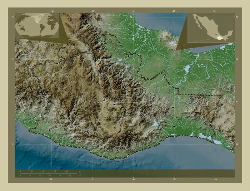
Free with trial Oaxaca, state of Mexico. Elevation map colored in wiki style with lakes and rivers. Locations of major cities of the region. Corner auxiliary location maps. Style elevation map illustrations Oaxaca, Mexico. Wiki. Major cities. Oaxaca, state of Mexico. Elevation map colored in wiki style with lakes and rivers. Locations of major cities of the region. Corner auxiliary location maps
Free with trial Cumbria, administrative county of England - Great Britain. Elevation map colored in wiki style with lakes and rivers. Corner auxiliary location maps. Style elevation map illustrations Cumbria, England - Great Britain. Wiki. Capital. Cumbria, administrative county of England - Great Britain. Elevation map colored in wiki style with lakes and rivers. Corner auxiliary location maps
Free with trial Varazdinska, county of Croatia. Elevation map colored in wiki style with lakes and rivers. Locations of major cities of the region. Corner auxiliary location maps. Style elevation map illustrations Varazdinska, Croatia. Wiki. Major cities. Varazdinska, county of Croatia. Elevation map colored in wiki style with lakes and rivers. Locations of major cities of the region. Corner auxiliary location maps
Free with trial Ras Al Khaymah, emirate of United Arab Emirates. Elevation map colored in wiki style with lakes and rivers. Corner auxiliary location maps. Style elevation map illustrations Ras Al Khaymah, United Arab Emirates. Wiki. Capital. Ras Al Khaymah, emirate of United Arab Emirates. Elevation map colored in wiki style with lakes and rivers. Corner auxiliary location maps
Free with trial Ras Al Khaymah, emirate of United Arab Emirates. Elevation map colored in wiki style with lakes and rivers. Style elevation map illustrations Ras Al Khaymah, United Arab Emirates. Wiki. No legend. Ras Al Khaymah, emirate of United Arab Emirates. Elevation map colored in wiki style with lakes and rivers
Free with trial Bihor, county of Romania. Elevation map colored in wiki style with lakes and rivers. Locations and names of major cities of the region. Corner auxiliary location maps. Style elevation map illustrations Bihor, Romania. Wiki. Labelled points of cities. Bihor, county of Romania. Elevation map colored in wiki style with lakes and rivers. Locations and names of major cities of the region. Corner auxiliary location maps
Free with trial Ankara, province of Turkiye. Elevation map colored in wiki style with lakes and rivers. Locations and names of major cities of the region. Corner auxiliary location maps. Style elevation map illustrations Ankara, Turkiye. Wiki. Labelled points of cities. Ankara, province of Turkiye. Elevation map colored in wiki style with lakes and rivers. Locations and names of major cities of the region. Corner auxiliary location maps
Free with trial Occitanie, region of France. Elevation map colored in wiki style with lakes and rivers. Locations and names of major cities of the region. Corner auxiliary location maps. Style elevation map illustrations Occitanie, France. Wiki. Labelled points of cities. Occitanie, region of France. Elevation map colored in wiki style with lakes and rivers. Locations and names of major cities of the region. Corner auxiliary location maps
Free with trial Eurasian tectonic plate on the Wiki style elevation map in the Loximuthal projection centered meridionally. Boundaries of other plates. Style elevation map illustrations Eurasian tectonic plate. Wiki. Loximuthal. Boundaries. Eurasian tectonic plate on the Wiki style elevation map in the Loximuthal projection centered meridionally. Boundaries of other plates
Free with trial Modern business background with dotted world map background and a globe. Style elevation map vectors Modern business background. Modern business background with dotted world map background and a globe
Free with trial Modern business background with dotted world map background and a globe. Style elevation map vectors Modern business background. Modern business background with dotted world map background and a globe
Free with trial A set of three minimalist illustrations with mountain relief, terrain, water, sea, streaks. Vintage posters with foot print. Style elevation map vectors Thin line backgrounds in warm colors for tourists and travelers. A set of three minimalist illustrations with mountain relief, terrain, water, sea, streaks. Vintage posters with foot print.
Free with trial Abstract city with skyscrapers background, futuristic city panorama. 3d illustration. Pink and blue colors. Style elevation map illustrations Abstract city with skyscrapers background, futuristic city panorama. 3d illustration.
Free with trial Abstract city with skyscrapers background, futuristic city panorama. 3d illustration. Pink. Style elevation map illustrations Abstract city with skyscrapers background, futuristic city panorama. 3d illustration.
Free with trial Welcome to Baku Azerbaijan famous architectural landmark skyline. Style elevation map vectors Welcome to Baku Azerbaijan famous architectural landmark skyline
Free with trial Topographic map with irregular contour lines representing elevation changes. Lines are smooth and closely spaced, depicting various peaks and valleys. The vector style is minimalist, utilizing black lines on a white background, emphasizing terrain features. The contours form concentric, organic shapes, each marking different elevation levels, suggesting a varied and hilly landscape. Style elevation map vectors Topographic Map with Elevation Lines in Flat Vector Style. Topographic map with irregular contour lines representing elevation changes. Lines are smooth and closely spaced, depicting various peaks and valleys. The vector style is minimalist, utilizing black lines on a white background, emphasizing terrain features. The contours form concentric, organic shapes, each marking different elevation levels, suggesting a varied and hilly landscape.
Free with trial Topographic map vintage style background. Land topography map vector design. Retro topographic elevation line map pattern. Style elevation map vectors Topographic map vintage style background
Free with trial Topographic map vector illustration. Imaginary mountain elevation map lines. Vintage style topo contour map. Geography texture. Style elevation map vectors Gold map background - elevation lines. Topographic map vector illustration. Imaginary mountain elevation map lines. Vintage style topo contour map. Geography texture
Free with trial Topographic map vector illustration. Imaginary mountain elevation map lines. Vintage style topo contour map. Travel texture. Style elevation map vectors Elevation lines topographic map background. Topographic map vector illustration. Imaginary mountain elevation map lines. Vintage style topo contour map. Travel texture
Free with trial Topographic map vector illustration. Imaginary mountain elevation map lines. Vintage style topo contour map texture. Style elevation map vectors Imaginary mountain elevation topography map. Topographic map vector illustration. Imaginary mountain elevation map lines. Vintage style topo contour map texture
Free with trial Antique-style physical world map depicting continents with textured elevation and varied colors indicating terrain differences such as mountains and plains. Oceans in blue surround the continents, with notable land masses including North and South America, Europe, Africa, Asia, and Australia. Polar regions show ice caps in white. Compass roses and vintage cartographic elements embellish the corners, adding a historical feel. The arrangement emphasizes global geographical features and demonstrates traditional map-making techniques. Style elevation map illustrations Antique-style physical world map depicting continents with textured elevation and varied colors
Free with trial A detailed flat style vector illustration of a contour map, showing elevation lines and terrain. This icon represents topographical data, geographical analysis, land surveying, and detailed mapping. Perfect for engineering, urban planning, or environmental studies, vector design Generative AI. Style elevation map vectors Contour map, topographical data and elevation, vector design Generative AI. A detailed flat style vector illustration of a contour map, showing elevation lines and terrain. This icon represents topographical data, geographical analysis, land surveying, and detailed mapping. Perfect for engineering, urban planning, or environmental studies, vector design Generative AI
Free with trial World map in a physical relief style, highlighting continents with varied colors representing terrain elevation. Green signifies lowlands, brown indicates mountains. Oceans are depicted in shades of blue, illustrating depths. Notable geographical features include the Himalayas in Asia and the Andes in South America. Major landmasses such as North America, South America, Africa, Europe, Asia, Australia, and Antarctica are identifiable. Additionally, Arctic and Antarctic polar ice caps are visible. Designed for visual educational purposes, emphasizing topographical diversity. Style elevation map illustrations World map in a physical relief style, highlighting continents with varied colors representing
Free with trial Topographic map background featuring detailed elevation contour lines in earthy brown and oceanic blue tones, illustrating both land and underwater terrain. The abstract scientific style captures precise elevation data through closely spaced lines and gradient shading, creating a visually engaging yet highly technical design. Dominated by organic curves and topographic layering, this image evokes geographic depth and spatial awareness, ideal for use in educational materials, scientific publications, outdoor adventure branding, mapping interfaces, or tech-themed presentations. The contrast between the land's elevation contours and the seabed bathymetry lines creates a compelling visual for both editorial and commercial design applications. Style elevation map illustrations Abstract Topographic Map with Elevation Contour Lines in Blue and Brown. Topographic map background featuring detailed elevation contour lines in earthy brown and oceanic blue tones, illustrating both land and underwater terrain. The abstract scientific style captures precise elevation data through closely spaced lines and gradient shading, creating a visually engaging yet highly technical design. Dominated by organic curves and topographic layering, this image evokes geographic depth and spatial awareness, ideal for use in educational materials, scientific publications, outdoor adventure branding, mapping interfaces, or tech-themed presentations.The contrast between the land's elevation contours and the seabed bathymetry lines creates a compelling visual for both editorial and commercial design applications.
Free with trial This image shows a three-dimensional representation of Earth's globe positioned above a layered, color-coded elevation map. The globe displays continents and oceans in a realistic style, while the map below features varying elevations indicated by different colors, including blue for lower elevations and orange for higher terrain. The map appears to be a topographic representation of a specific. Style elevation map illustrations 3d globe positioned over a layered, color-coded elevation map isolated on transparent background, isolated on white background. This image shows a three-dimensional representation of Earth's globe positioned above a layered, color-coded elevation map. The globe displays continents and oceans in a realistic style, while the map below features varying elevations indicated by different colors, including blue for lower elevations and orange for higher terrain. The map appears to be a topographic representation of a specific
Free with trial A high-contrast, black and white 3D representation of a geographical terrain map. The image displays a stylized isometric view of mountain peaks, ridges, and valleys, using layered shading to depict elevation changes. The visual style resembles a digital elevation model or a topographical survey map, emphasizing the geometric structure of the landscape against a circular background base. Style elevation map illustrations A detailed monochromatic topographic 3d elevation model map showcasing rugged mountain terrain and natural valley landscape. A high-contrast, black and white 3D representation of a geographical terrain map. The image displays a stylized isometric view of mountain peaks, ridges, and valleys, using layered shading to depict elevation changes. The visual style resembles a digital elevation model or a topographical survey map, emphasizing the geometric structure of the landscape against a circular background base
Free with trial Journey back in time with this captivating vintage elevation map of the Rocky Mountains. Rendered in an antique style, the topographical chart meticulously details the rugged terrain and soaring peaks of this iconic mountain range. Intricate lines reveal the contours of valleys, ridges, and summits, providing a fascinating glimpse into the region's dramatic geography. This detailed. Style elevation map illustrations Explore the Majestic Rocky Mountains A Detailed Vintage Elevation Map Unveiling HighAltitude Terrain and Scenic. Journey back in time with this captivating vintage elevation map of the Rocky Mountains. Rendered in an antique style, the topographical chart meticulously details the rugged terrain and soaring peaks of this iconic mountain range. Intricate lines reveal the contours of valleys, ridges, and summits, providing a fascinating glimpse into the region's dramatic geography. This detailed
Free with trial Topographic map, paper cut style, dark gray background, curved layers, elevation contour lines, banner design. Generative AI. Style elevation map illustrations Topographic map, paper cut style, dark gray background, curved layers, elevation contour lines, banner design
Free with trial Generative AI abstract topographic map in layered green tones, designed in a paper-cut style. The smooth organic shapes resemble elevation contours or stylized landforms. Ideal for use in eco-friendly branding, educational materials, infographic backgrounds, or modern design projects focused on geography, nature, or sustainability. Style elevation map illustrations . Generative AI abstract topographic map in layered green tones, designed in a paper-cut style. The smooth organic shapes resemble elevation contours or stylized landforms. Ideal for use in eco-friendly branding, educational materials, infographic backgrounds, or modern design projects focused on geography, nature, or sustainability
Free with trial This captivating topographic map showcases a mountainous region in exquisite detail. The intricate network of contour lines meticulously reveals the elevation variations, slopes, and valleys. Each line style, carefully crafted, represents a specific elevation, allowing the viewer to visualize the terrain's three-dimensional form. The map's clarity and precision make it an invaluable tool for. Style elevation map illustrations Unveiling Mountainous Landscapes A Detailed Topographic Map Depicting Elevation Changes and Terrain Features Through. This captivating topographic map showcases a mountainous region in exquisite detail. The intricate network of contour lines meticulously reveals the elevation variations, slopes, and valleys. Each line style, carefully crafted, represents a specific elevation, allowing the viewer to visualize the terrain's three-dimensional form. The map's clarity and precision make it an invaluable tool for
Free with trial Journey through the heart of Europe with this captivating vintage-style 3D topographic map. Experience the continent's breathtaking landscapes in a unique and engaging format. The detailed relief model vividly portrays the elevation changes, showcasing the dramatic peaks of the Alps, the rolling hills of central Europe, and the rugged coastline along the Mediterranean. Intricate valleys and. Style elevation map illustrations A Stunning Vintage 3D Topographic Map of Europe Detailed Relief Vibrant Colors and Intricate Elevation Changes Showcase. Journey through the heart of Europe with this captivating vintage-style 3D topographic map. Experience the continent's breathtaking landscapes in a unique and engaging format. The detailed relief model vividly portrays the elevation changes, showcasing the dramatic peaks of the Alps, the rolling hills of central Europe, and the rugged coastline along the Mediterranean. Intricate valleys and
Free with trial Satellite-generated LiDAR GIS map rendering showing layered elevation contours and detailed topography in semi-transparent style. Generative AI. Style elevation map illustrations Satellite-generated LiDAR GIS map rendering showing layered elevation contours and detailed topography in semi-transparent style.
Free with trial Satellite-generated LiDAR GIS map rendering showing layered elevation contours and detailed topography in semi-transparent style. Generative AI. Style elevation map illustrations Satellite-generated LiDAR GIS map rendering showing layered elevation contours and detailed topography in semi-transparent style.
Free with trial Satellite-generated LiDAR GIS map rendering showing layered elevation contours and detailed topography in semi-transparent style. Generative AI. Style elevation map illustrations Satellite-generated LiDAR GIS map rendering showing layered elevation contours and detailed topography in semi-transparent style.
Free with trial Topographic map vintage style background. Land topography map vector design. Retro topographic elevation line map pattern. Style elevation map vectors Travel background height map. Topographic map vintage style background. Land topography map vector design. Retro topographic elevation line map pattern
Free with trial Topographic map style geometric background. Land topography map vector design. Style elevation map vectors Topographic map style geometric background
Free with trial Topographic map style geometric blue white background. Land topography map vector design. Style elevation map vectors Elevation map background. Topographic map style geometric blue white background. Land topography map vector design
Free with trial A seamless pattern of abstract topographic contour lines in beige against a clean white background, suggesting elevation and terrain in a minimalist style. topographic map, contour. Style elevation map vectors Abstract Topographic Contour Lines Pattern topographic map. A seamless pattern of abstract topographic contour lines in beige against a clean white background, suggesting elevation and terrain in a minimalist style. topographic map, contour
Free with trial Elevation map vector background. Topographic map style geometric background. Land topography map vector design. Style elevation map vectors Elevation map vector background. Topographic map style geometric background. Land topography map vector design
Free with trial Detailed vintage engraving illustration of topographic contour lines forming a realistic terrain map texture in ink drawing style. Perfect for cartography projects, geographic navigation themes, scientific visuals, atlas layouts, and map backgrounds. Style elevation map vectors Topographic Contour Lines Map Background Vector Illustration in Vintage Engraving Ink Style. Detailed vintage engraving illustration of topographic contour lines forming a realistic terrain map texture in ink drawing style. Perfect for cartography projects, geographic navigation themes, scientific visuals, atlas layouts, and map backgrounds
Free with trial Is an isometric 3D of a stylized map featuring a large green landmass surrounded by blue water. The terrain includes a central mountain range depicted in brown, with a small red marker placed near the composition uses flat colors and geometric shapes to represent geographic such as land, water, and elevation. The style is minimal and abstract, designed for clarity and visual appeal in a flat. Style elevation map illustrations Isometric 3 d map with green land, blue water, and brown mountains. is an isometric 3D of a stylized map featuring a large green landmass surrounded by blue water. The terrain includes a central mountain range depicted in brown, with a small red marker placed near the composition uses flat colors and geometric shapes to represent geographic such as land, water, and elevation. The style is minimal and abstract, designed for clarity and visual appeal in a flat
Free with trial Abstract topographic map style background in dark red hues. Layered contours create a sense of depth and elevation. Textured abstract art. Style elevation map vectors Dark red abstract topographic map background with layered contours and shadows. Abstract topographic map style background in dark red hues. Layered contours create a sense of depth and elevation. Textured abstract art
Free with trial Abstract topographic map design featuring a series of overlapping, curved contour lines in varying shades of teal on a light turquoise background. The lines create an intricate, layered pattern that suggests elevation changes and forms suggestive of a three-dimensional landscape. This style is typically used for visualizing terrain in cartography. The image uses a monochromatic color scheme, emphasizing the complexity and depth of the depicted topography. Style elevation map illustrations Abstract topographic map design featuring a series of overlapping, curved contour lines
Free with trial A stylized topographic map of Asia, showcasing the continent's diverse terrain and geographical features in a three-dimensional, textured relief style. The image uses warm and cool tones to emphasize the elevation changes. Style elevation map illustrations Asia map textured relief view. A stylized topographic map of Asia, showcasing the continent's diverse terrain and geographical features in a three-dimensional, textured relief style. The image uses warm and cool tones to emphasize the elevation changes
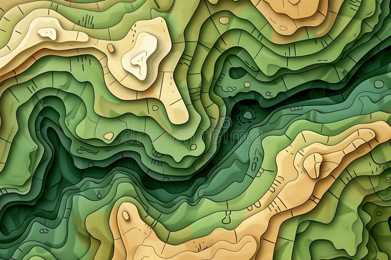
Free with trial This digital artwork depicts a stylized topographical map featuring a landscape of gently rolling green hills and valleys. The color palette consists primarily of varying shades of green and beige, creating a sense of depth and elevation. The lines used to contour the hills are clean and visually appealing, creating a harmonious and almost abstract representation of terrain. The style mimics a paper-cut or layered effect giving it a unique three-dimensional appearance. The overall effect is peaceful and visually engaging, hinting at a tranquil natural environment. Style elevation map illustrations Topographical Map Illustration of Rolling Green Hills. This digital artwork depicts a stylized topographical map featuring a landscape of gently rolling green hills and valleys. The color palette consists primarily of varying shades of green and beige, creating a sense of depth and elevation. The lines used to contour the hills are clean and visually appealing, creating a harmonious and almost abstract representation of terrain. The style mimics a paper-cut or layered effect giving it a unique three-dimensional appearance. The overall effect is peaceful and visually engaging, hinting at a tranquil natural environment.