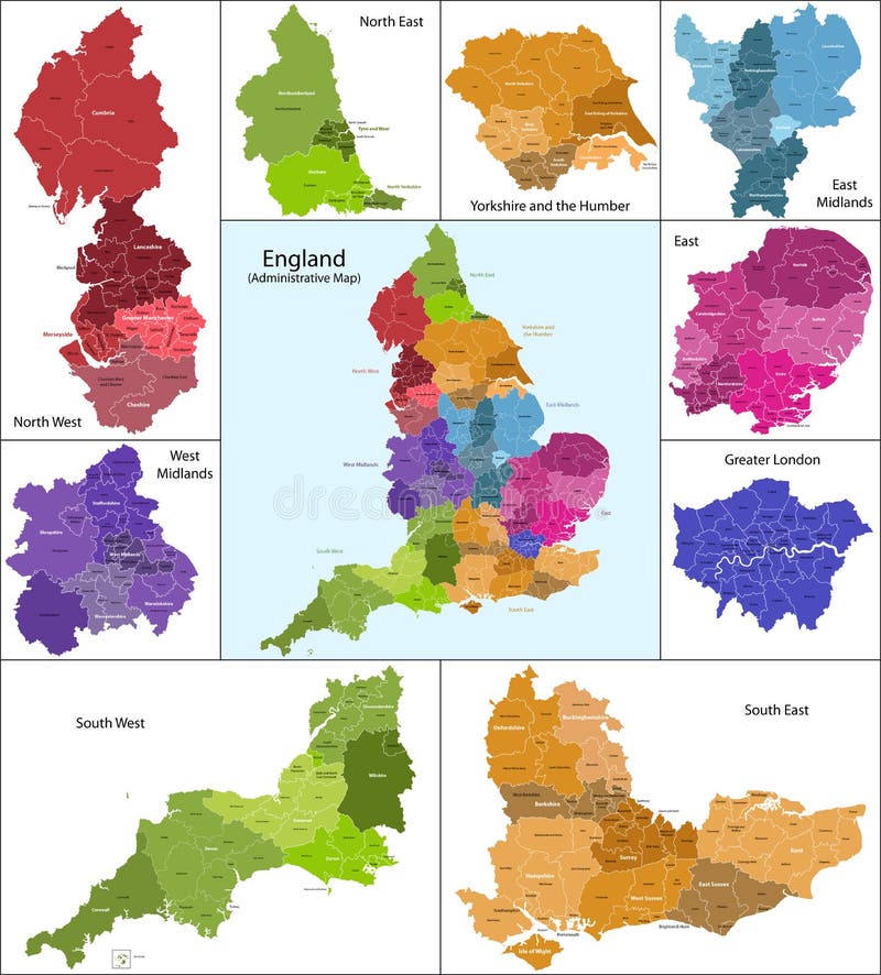
Free with trial The map shows the current subdivisions of England with a principal local authority: two-tier non-metropolitan counties and their non-metropolitan districts, metropolitan boroughs, unitary authorities, London boroughs and the sui generis City of London and Isles of Scilly. Greater vectors England map. The map shows the current subdivisions of England with a principal local authority: two-tier non-metropolitan counties and their non-metropolitan. The map shows the current subdivisions of England with a principal local authority: two-tier non-metropolitan counties and their non-metropolitan districts, metropolitan boroughs, unitary authorities, London boroughs and the sui generis City of London and Isles of Scilly
Free with trial People are going to the new better world. , conceptual illustration. Greater vectors New better world. People are going to the new better world., conceptual illustration. People are going to the new better world., conceptual illustration.
Free with trial 66 pieces of detailed vectoral fish silhouettes. Jpeg involves paths. Illustrator. ai file included. Greater vectors Detailed Vectoral Fish Silhouettes. 66 pieces of detailed vectoral fish silhouettes. Jpeg involves paths. Illustrator .ai file included. 66 pieces of detailed vectoral fish silhouettes. Jpeg involves paths. Illustrator .ai file included.
Free with trial Greater Kudu. Has the longest horns in the world. Greater vectors Greater Kudu. Has the longest horns in the world
Free with trial China Greater Bay Area Map in gray. Guangdong, Hong Kong, Macao, Greater Bay Area in China. Greater vectors China Greater Bay Area Map in gray. Greater Bay Area Map in gray. Guangdong, Hong Kong, Macao, Greater Bay Area in China
Free with trial Hispaniola Political Map with Haiti and Dominican Republic, located in the Caribbean island group, the Greater Antilles. With capitals, national borders, important cities, rivers and lakes. English labeling and scaling. Illustration. Greater vectors Hispaniola Political Map with Haiti and Dominican Republic. Located in the Caribbean island group, the Greater Antilles. With capitals, national borders. Hispaniola Political Map with Haiti and Dominican Republic, located in the Caribbean island group, the Greater Antilles. With capitals, national borders, important cities, rivers and lakes. English labeling and scaling. Illustration.
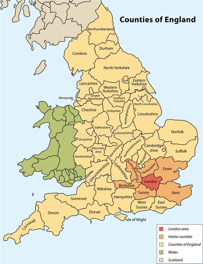
Free with trial Counties of England on vector map. Greater vectors Counties of England. On vector map
Free with trial Deep sea fish oil. Contained in a bottle, water background 3d illustration. Greater vectors Deep sea fish oil. Contained in a bottle, water background 3d illustration
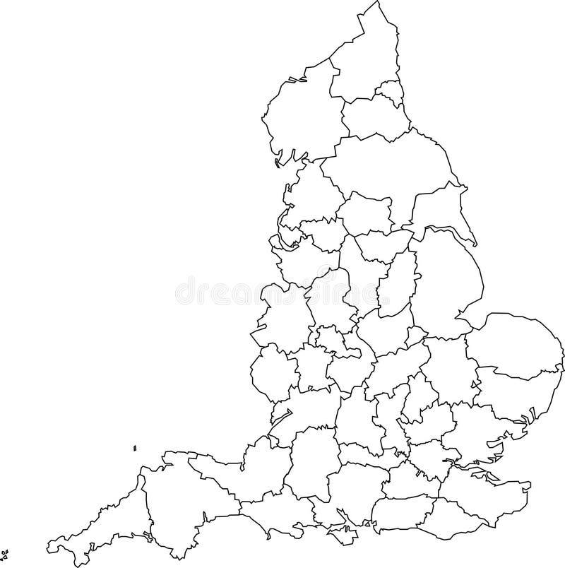
Free with trial A blank map of England featuring geographical counties (also known as ceremonial counties or Lieutenancy Areas). Greater vectors Blank map of England - counties. A blank map of England featuring geographical counties (also known as ceremonial counties or Lieutenancy Areas. A blank map of England featuring geographical counties (also known as ceremonial counties or Lieutenancy Areas)
Free with trial Serve II. Grouped and layered for easier editing. An Illustrator file is included for even greater control. Greater vectors Serve II. Grouped and layered for easier editing. An Illustrator file is included for even greater control
Free with trial Love in hand. Multi-coloured prints of hands with heart. Greater vectors Love in hand. Multi-coloured prints of hands with heart
Free with trial Reverse osmosis use the membrane to act like an extremely fine filter to create drinking water from contaminated water. Pressure is applied to the contaminated water forcing water molecules through the membrane. solvent moves from a solution of greater concentration through a membrane to a solution of lesser concentration. Greater vectors Reverse Osmosis. Use the membrane to act like an extremely fine filter to create drinking water from contaminated water. Pressure is applied to the contaminated. Reverse osmosis use the membrane to act like an extremely fine filter to create drinking water from contaminated water. Pressure is applied to the contaminated water forcing water molecules through the membrane. solvent moves from a solution of greater concentration through a membrane to a solution of lesser concentration.
Free with trial Australia map and cities. Australia map and words cloud with larger cities. Greater vectors Australia map and cities. Australia map and words cloud with larger cities
Free with trial Vector illustration of various mathematical symbols and numbers as written on a chalk board. Greater vectors Chalk Vector Math Symbols and Numbers. Vector illustration of various mathematical symbols and numbers as written on a chalk board. Vector illustration of various mathematical symbols and numbers as written on a chalk board.
Free with trial Vector illustration of a human pelvis and hip with pain in the hip joint and trochanteric bursitis. Front view. For advertising and medical publications. EPS 10. Greater vectors Pain in the hip joint_trochanteric bursitis. Vector illustration of a human pelvis and hip with pain in the hip joint and trochanteric bursitis. Front view. For. Vector illustration of a human pelvis and hip with pain in the hip joint and trochanteric bursitis. Front view. For advertising and medical publications. EPS 10.
Free with trial Greater roadrunner bird. Illustration of greater roadrunner bird. Greater vectors Greater roadrunner bird. Illustration of greater roadrunner bird
Free with trial Greater Antilles political map. Caribbean islands. Cuba, Jamaica, Haiti, Dominican Republic, Puerto Rico, Cayman Islands, The Bahamas, Turks And Caicos Islands. Illustration. English labeling. Vector. Greater vectors Greater Antilles political map. Caribbean islands. Cuba, Jamaica, Haiti, Dominican Republic, Puerto Rico, Cayman Islands, The Bahamas, Turks And Caicos Islands
Free with trial Vector Greater London administrative map. View from above. Greater vectors Vector Greater London administrative map. View from above
Free with trial Vector cuckoo Greater Roadrunner Geococcyx californianus. Illustration. Greater vectors Vector cuckoo Greater Roadrunner Geococcyx californianus. Illustration
Free with trial Greater kudu is One of the most beautiful antelope. Greater vectors Antelope Series Greater kudu. Greater kudu is One of the most beautiful antelope. Greater kudu is One of the most beautiful antelope.
Free with trial Greater London Road And Administrative Map, eps 10. Greater vectors Greater london road and administrative map. Eps 10. Greater London Road And Administrative Map, eps 10
Free with trial Vector street map of greater Los Angeles area, California, United States. Greater vectors Vector street map of greater Los Angeles area, California, United States.
Free with trial In order to succeed, your desire for success should be greater than your fear of failure. Motivational background. Typography poster. Greater vectors Motivational Background. In order to succeed, your desire for success should be greater than your fear of failure. Motivational background. Typography poster. In order to succeed, your desire for success should be greater than your fear of failure. Motivational background. Typography poster.
Free with trial Kurdistan, Kurdish lands political map. Cultural region wherein Kurdish people form a prominent majority. Greater Kurdistan includes parts of Turkey, Syria, Iraq, Iran and Armenia. English labeling. Greater vectors Kurdistan, Kurdish lands political map. Cultural region wherein Kurdish people form a prominent majority. Greater Kurdistan includes parts of Turkey, Syria
Free with trial Motivational Quote Poster About Success In order to succeed your desire for success should be greater than your fear of failure. Greater vectors Motivational Quote Poster About Success In order to succeed your desire for success should be greater than your fear of. Failure
Free with trial Big set of Horn, antlers Animals moose or elk with impala, gazelle and greater kudu, fallow deer reindeer and stag, doe or roe deer, axis and dibatag hand drawn, engraved. Greater vectors Big set of Horn, antlers Animals moose or elk with impala, gazelle and greater kudu, fallow deer reindeer and stag, doe. Or roe deer, axis and dibatag hand
Free with trial Math Icon Set 2. 16 icon set of mathematical operations symbols. Greater vectors Math Icon Set 2. 16 icon set of mathematical operations symbols
Free with trial A motivational and inspirational poster representing the proverb sayings, Wisdom is Better than Strength with simple human pictogram. Greater vectors Wisdom is Better than Strength. A motivational and inspirational poster representing the proverb sayings, Wisdom is Better than Strength with simple human. A motivational and inspirational poster representing the proverb sayings, Wisdom is Better than Strength with simple human pictogram.
Free with trial Recovery, empty wheelchair and child is going to the new better future. Greater vectors Recovery. Empty wheelchair and child is going to the new better future
Free with trial Birds-set colorful birds low poly design on white background. Greater vectors Birds set. Birds-set colorful birds low poly design on white background. Birds-set colorful birds low poly design on white background.
Free with trial Merry green frog. Illustration, merry green frog with greater eye. Greater vectors Merry green frog. Illustration, merry green frog with greater eye
Free with trial Hand vector. Square multi color hands vector. Greater vectors Hand vector. Square multi color hands vector
Free with trial Child is going to the new better future. Greater vectors Broken wall. Child is going to the new better future. Child is going to the new better future.
Free with trial Birds-set colorful birds low poly design on white background. Greater vectors Set of birds. Birds-set colorful birds low poly design on white background. Birds-set colorful birds low poly design on white background.
Free with trial Math icons set. Isolated black math icons set from white baclground. Greater vectors Math icons set. Isolated black math icons set from white baclground
Free with trial Cartoon Woodpecker. A cartoon woodpecker attacks a tree trunk. Greater vectors Cartoon Woodpecker. A cartoon woodpecker attacks a tree trunk
Free with trial Face of the green alien with the big head and greater black eyes. The stylized image. Greater vectors Face of another mind. Face of the green alien with the big head and greater black eyes. The stylized image. Face of the green alien with the big head and greater black eyes. The stylized image.
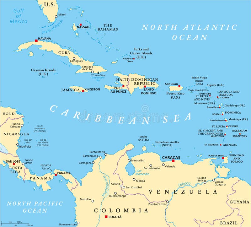
Free with trial Caribbean political map with capitals, national borders, important cities, rivers and lakes. English labeling and scaling. Illustration. Greater vectors Caribbean Political Map. With capitals, national borders, important cities, rivers and lakes. English labeling and scaling. Illustration
Free with trial Lever with box and ball. simple machines by Archimedes. lever is a machine consisting of a beam or rigid rod pivoted at a fixed hinge or fulcrum. Vector illustration for education and science use. Greater vectors Lever with box and ball. Simple machines by Archimedes. lever is a machine consisting of a beam or rigid rod pivoted at a fixed hinge or fulcrum. Vector
Free with trial Woodpecker. Great spotted woodpecker,dendrocopos major,side view picture isolated on white background. Greater vectors Woodpecker. Great spotted woodpecker,dendrocopos major,side view picture isolated on white background
Free with trial The Caribbean Physical Map. Highly detailed vector illustration. Greater vectors The Caribbean Physical Map. Highly detailed vector illustration
Free with trial Simple machines: Lever - Tongs- vector illustration. Greater vectors Simple machines: Lever - Tongs. Vector illustration
Free with trial Frog. Illustration, merry green frog with greater eye. Greater vectors Frog. Illustration, merry green frog with greater eye
Free with trial Frog. Illustration, merry green frog with greater eye. Greater vectors Frog. Illustration, merry green frog with greater eye
Free with trial Human stomach. Sections of the human stomach. Greater vectors Human stomach. Sections of the human stomach
Free with trial Frog. Illustration, merry green frog with greater eye. Greater vectors Frog. Illustration, merry green frog with greater eye
Free with trial Lever. simple machines. Archimedes. lever is a machine consisting of a beam or rigid rod pivoted at a fixed hinge or fulcrum. Lever, one of the six simple machines identified by Renaissance scientists. Greater vectors Lever. simple machines. Archimedes. Lever is a machine consisting of a beam or rigid rod pivoted at a fixed hinge or fulcrum. Lever, one of the six simple
Free with trial Anatomy of human stomach, illustration (for basic medical education, for clinics & Schools). Greater vectors Human stomach. Anatomy of human stomach, illustration (for basic medical education, for clinics & Schools. Anatomy of human stomach, illustration (for basic medical education, for clinics & Schools)
Free with trial Vector Award Ribbons - 1st, 2nd, 3rd, plus sayings such as Grand Champion, Superstar, Nice Job, You Totally Rock! and Superstar. Greater vectors 1st, 2nd, and 3rd Place Ribbons and More Vector. Vector Award Ribbons - 1st, 2nd, 3rd, plus sayings such as Grand Champion, Superstar, Nice Job, You Totally Rock. Vector Award Ribbons - 1st, 2nd, 3rd, plus sayings such as Grand Champion, Superstar, Nice Job, You Totally Rock! and Superstar
Free with trial Highly detailed vector map of Dominican Republic and Haiti with administrative regions, main cities and roads. Greater vectors Dominican Republic and Haiti map. Highly detailed vector map of Dominican Republic and Haiti with administrative regions, main cities and roads. Highly detailed vector map of Dominican Republic and Haiti with administrative regions, main cities and roads.
Free with trial Private residence. Country private residence, house with greater windows and red tile. Greater vectors Private residence. Country private residence, house with greater windows and red tile
Free with trial Simple machines:Lever - Pliers - vector illustration. Greater vectors Simple machines:Lever - Pliers. Vector illustration
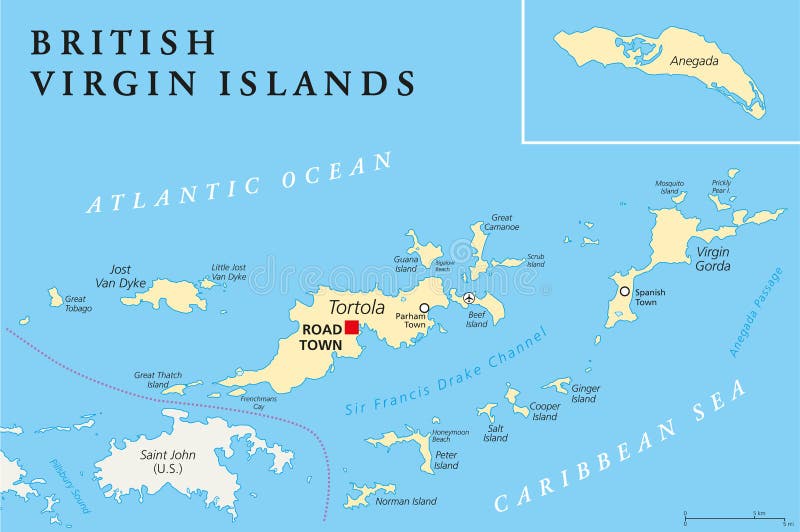
Free with trial British Virgin Islands Political Map, a british overseas territory located between the Caribbean Sea and the Atlantic Ocean and part of the Virgin islands archipelago. English labeling and scaling. Illustration. Greater vectors British Virgin Islands Political Map. A british overseas territory located between the Caribbean Sea and the Atlantic Ocean and part of the Virgin islands. British Virgin Islands Political Map, a british overseas territory located between the Caribbean Sea and the Atlantic Ocean and part of the Virgin islands archipelago. English labeling and scaling. Illustration.
Free with trial Math Financial Symbols. Colorful math financial symbols set. Greater vectors Math Financial Symbols. Colorful math financial symbols set
Free with trial UAE United Arab Emirates political map with capital Abu Dhabi, national borders, important cities and bodies of water. English labeling and scaling. Illustration. Greater vectors UAE United Arab Emirates Political Map. With capital Abu Dhabi, national borders, important cities and bodies of water. English labeling and scaling
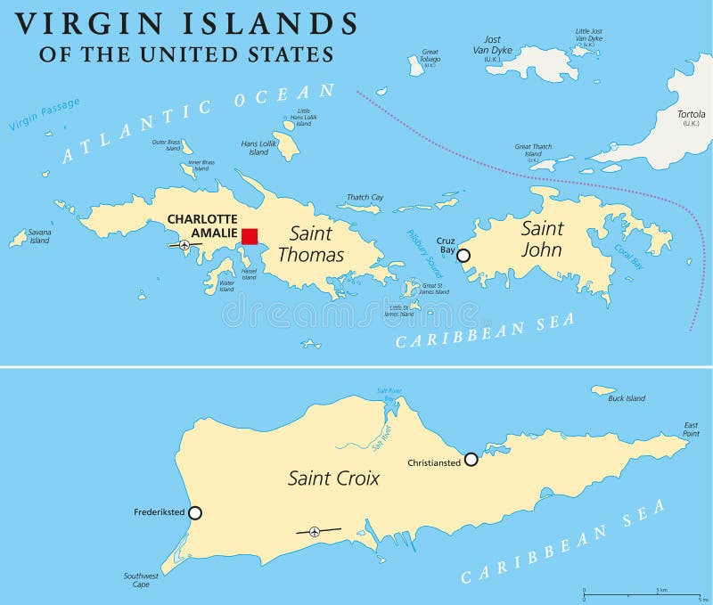
Free with trial United States Virgin Islands Political Map. A group of islands in the Caribbean that are an insular area of the United States. English labeling and scaling. Illustration. Greater vectors United States Virgin Islands Political Map. A group of islands in the Caribbean that are an insular area of the United States. English labeling and scaling
Free with trial Simple machines: Lever - Nutcracker- vector illustration. Greater vectors Simple machines: Lever - Nutcracker. Vector illustration
Free with trial Set a target for shooting range, bullet holes, vector. Greater vectors Set a target for shooting range, bullet holes, vector. Set a target for shooting range, bullet holes, vector
Free with trial Blue map of Poland with voivodeships on white projected in UTM coordinate system. Greater vectors Blue map of Poland with voivodeships. On white projected in UTM coordinate system
Free with trial Strait of Hormuz, Abu Musa and the Tunbs political map. Only sea passage from Persian Gulf to Arabian Sea. One of the most strategically important choke points in world. English labeling. Illustration. Greater vectors Strait of Hormuz, Abu Musa and the Tunbs Political Map. Only sea passage from Persian Gulf to Arabian Sea. One of the most strategically important choke points
Free with trial Illustration of the major veins of the leg from the front (anterior) and back (posterior). Greater vectors Major veins of the leg. Illustration of the major veins of the leg from the front (anterior) and back (posterior. Illustration of the major veins of the leg from the front (anterior) and back (posterior)
Free with trial Dominican Republic Political Map with capital Santo Domingo, with national borders, important cities, rivers and lakes. English labeling and scaling. Illustration. Greater vectors Dominican Republic Political Map. With capital Santo Domingo, with national borders, important cities, rivers and lakes. English labeling and scaling
Free with trial Arabian oryx is a kind of rare antelope. Greater vectors Antelope Series Arabian oryx. Arabian oryx is a kind of rare antelope. Arabian oryx is a kind of rare antelope.
Free with trial Puerto rico map. Puerto rico vector road map. Greater vectors Puerto rico map. Puerto rico vector road map
Free with trial Map of the city of Toronto, Canada. Vector map of the city of Toronto, Canada. Greater vectors Map of the city of Toronto, Canada. Vector map of the city of Toronto, Canada
Free with trial Map of the city of Houston, U. S. state of Texas, USA. Vector map of the city of Houston, U. Greater vectors Map of the city of Houston, U.S. state of Texas, USA. Vector map of the city of Houston, U.S. state of Texas, USA
Free with trial Mathematical equation describing synergy effect, it mean that working together will result in greater efficiency. Greater vectors Synergy Effect, Working Together Mean More. Mathematical equation describing synergy effect, it mean that working together will result in greater efficiency. Mathematical equation describing synergy effect, it mean that working together will result in greater efficiency.
Free with trial Map of the city of Houston, U. S. state of Texas, USA. Vector map of the city of Houston, U. Greater vectors Map of the city of Houston, U.S. state of Texas, USA. Vector map of the city of Houston, U.S. state of Texas, USA
Free with trial Map of the city of Toronto, Canada. Vector map of the city of Toronto, Canada. Greater vectors Map of the city of Toronto, Canada. Vector map of the city of Toronto, Canada
Free with trial This image is a vector illustration and can be scaled to any size without loss of resolution, can be variated and used for different compositions. This image is an. eps file and you will need a vector editor to use this file, such as Adobe Illustrator. Greater vectors Animals of Australia. This image is a vector illustration and can be scaled to any size without loss of resolution, can be variated and used for different. This image is a vector illustration and can be scaled to any size without loss of resolution, can be variated and used for different compositions. This image is an . eps file and you will need a vector editor to use this file, such as Adobe Illustrator.
Free with trial Detailed accurate map of London in high resolution. Vector illustration. Greater vectors Detailed accurate map of London in high resolution. Vector illustration
Free with trial Math crossword puzzles worksheet. Easy worksheet, for children in preschool, elementary and middle school. Greater vectors Math crossword puzzles worksheet. Easy worksheet, for children in preschool, elementary and middle school
Free with trial Math crossword puzzles worksheet. Easy worksheet, for children in preschool, elementary and middle school. Greater vectors Math crossword puzzles worksheet. Easy worksheet, for children in preschool, elementary and middle school
Free with trial Map of the Golden Horseshoe metropolitan area around the western end of Lake Ontario, Ontario. Canada. Greater vectors Map of the Golden Horseshoe metropolitan area around the western end of Lake Ontario Ontario Canada. Map of the Golden Horseshoe metropolitan area around the. Map of the Golden Horseshoe metropolitan area around the western end of Lake Ontario, Ontario. Canada
Free with trial Map of the city of Houston, U. S. state of Texas, USA. Vector map of the city of Houston, U. Greater vectors Map of the city of Houston, U.S. state of Texas, USA. Vector map of the city of Houston, U.S. state of Texas, USA
Free with trial Math crossword puzzles worksheet. Easy worksheet, for children in preschool, elementary and middle school. Greater vectors Math crossword puzzles worksheet. Easy worksheet, for children in preschool, elementary and middle school
Free with trial Math crossword puzzles worksheet. Easy worksheet, for children in preschool, elementary and middle school. Greater vectors Math crossword puzzles worksheet. Easy worksheet, for children in preschool, elementary and middle school
Free with trial Fill in the missing numbers. Easy colorful math crossword puzzles. For preschool, elementary and middle school kids. Greater vectors Fill in the missing numbers. Easy colorful math crossword puzzles. For preschool, elementary and middle school kids
Free with trial Vector map of British Isles administrative divisions colored by countries and regions. Districts and counties maps and flags of United Kingdom,Northern Ireland, Wales, Scotland and Republic of Ireland. Greater vectors Vector map of British Isles administrative divisions colored by countries and regions. Districts and counties maps and flags of United Kingdom,Northern Ireland
Free with trial Jamaica set. Detailed country shape with region borders, flags and icons isolated on white background. Greater vectors Jamaica set. Detailed country shape with region borders, flags and icons isolated on white background
 Sign in