Free with trial City Map Destination Route. Illustration. Mapping vectors City Map Destination Route. Illustration
Free with trial Abstract Colorful Vector 3d Large Mind Map Infographic. Web Element. Mapping vectors Abstract Colorful Vector 3d Large Mind Map Infographic. Web Element. Abstract Cool Colorful Vector 3d Large Mind Map Infographic. Web Element
Free with trial Cuba. Vector color map of Cuba country. Mapping vectors Cuba. Vector color map of Cuba country
Free with trial Stylized map of the area of the gulf of mexico. German captions. Mapping vectors Map of the area of the gulf of mexico. Stylized map of the area of the gulf of mexico. German captions. Stylized map of the area of the gulf of mexico. German captions.
Free with trial A stylized map of the islands of Samoa showing different big cities. Mapping vectors Map of Samoa. A stylized map of the islands of Samoa showing different big cities. A stylized map of the islands of Samoa showing different big cities.
Free with trial Map of Northern Hemisphere - Albers projection. A colored vector map of the northern hemisphere in Albers projection, showing longitudes and latitudes. Mapping vectors Map of Northern Hemisphere - Albers projection. A colored vector map of the northern hemisphere in Albers projection, showing longitudes and latitudes
Free with trial Abstract background with a Christmas gift. Vector. Mapping vectors Christmas gift. Abstract background with a Christmas gift. Vector. Abstract background with a Christmas gift. Vector.
Free with trial Mobile phone with pointer on screen, gps concept in flat style. Illustration. Mapping vectors Mobile phone with pointer on screen, gps concept in flat style. Illustration
Free with trial World Map - Equirectangular grid. A black and white vector world map. Mapping vectors World Map - Equirectangular grid. A black and white vector world map
Free with trial Road element set. With different traffic signs, curves, and lanes. Mapping vectors Road element set. With different traffic signs, curves, and lanes
Free with trial Digital marketing banner web icon for business and social media marketing, content marketing, website, viral, seo, keyword, advertise and internet online marketing. Minimal vector infographic. Mapping vectors Digital marketing banner web icon for business and social media marketing. Content marketing, website, viral, seo, keyword, advertise and internet online. Digital marketing banner web icon for business and social media marketing, content marketing, website, viral, seo, keyword, advertise and internet online marketing. Minimal vector infographic
Free with trial Contour line map. Elevation contouring outline cartography texture. Topographical relief map vector background. Mapping vectors Contour line map. Elevation contouring outline cartography texture. Topographical relief map background. Contour line map. Elevation contouring outline. Contour line map. Elevation contouring outline cartography texture. Topographical relief map vector background
Free with trial Political world map. Illustration of the globe, depicting the political world. Mapping vectors Political world map. Illustration of the globe, depicting the political world
Free with trial A stylized map of the Netherlands showing different big cities as well as nearby countries. Mapping vectors Map of the Netherlands. A stylized map of the Netherlands showing different big cities as well as nearby countries. A stylized map of the Netherlands showing different big cities as well as nearby countries.
Free with trial Ohio, OH, political map. State in East North Central region of Midwestern United States of America. Capital Columbus. The Buckeye State. Birthplace of Aviation. Heart of It All. Illustration. Vector. Mapping vectors Ohio, OH, political map, The Buckeye State, The Heart of It All. Ohio, OH, political map. State in East North Central region of Midwestern United States of. Ohio, OH, political map. State in East North Central region of Midwestern United States of America. Capital Columbus. The Buckeye State. Birthplace of Aviation. Heart of It All. Illustration. Vector.
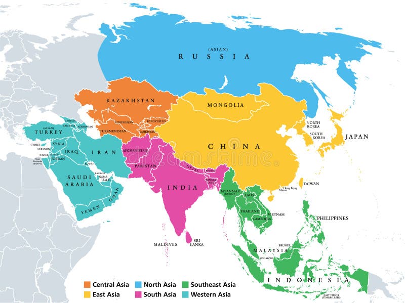
Free with trial Main regions of Asia. Political map with single countries. Colored subregions of the Asian continent. Central, East, North, South, Southeast and Western Asia. English labeled. Illustration. Vector. Mapping vectors Asia, continent, main regions, political map with subregions. Main regions of Asia. Political map with single countries. Colored subregions of the Asian. Main regions of Asia. Political map with single countries. Colored subregions of the Asian continent. Central, East, North, South, Southeast and Western Asia. English labeled. Illustration. Vector.
Free with trial DNA data chart. Medicine test graphic, abstract genome sequences graph and genomics map. Medicine genomics data sequences, antibody testing or genetic chromosome barcoding vector illustration. Mapping vectors DNA data chart. Medicine test graphic, abstract genome sequences graph and genomics map vector illustration. DNA data chart. Medicine test graphic, abstract. DNA data chart. Medicine test graphic, abstract genome sequences graph and genomics map. Medicine genomics data sequences, antibody testing or genetic chromosome barcoding vector illustration
Free with trial Thin lines icons set of geo-location mapping pin, global positioning system navigation, geo targeting marker, satellite signal. Modern infographic outline vector design, simple logo pictogram concept. Mapping vectors Geo location and navigation line icons set. Thin lines icons set of geo-location mapping pin, global positioning system navigation, geo targeting marker. Thin lines icons set of geo-location mapping pin, global positioning system navigation, geo targeting marker, satellite signal. Modern infographic outline vector design, simple logo pictogram concept.
Free with trial Map Austria. A simple map of austria. Mapping vectors Map Austria. A simple map of austria
Free with trial A stylized map of Poland showing the different provinces. All isolated on white background. Mapping vectors Map of Poland. A stylized map of Poland showing the different provinces. All isolated on white background. A stylized map of Poland showing the different provinces. All isolated on white background.
Free with trial World Map - Mercator Projection. A black and white vector world map in Mercator projection, showing longitudes and latitudes. Mapping vectors World Map - Mercator Projection. A black and white vector world map in Mercator projection, showing longitudes and latitudes
Free with trial A stylized map of Portugal showing the different provinces. All isolated on white background. Mapping vectors Map of Portugal. A stylized map of Portugal showing the different provinces. All isolated on white background. A stylized map of Portugal showing the different provinces. All isolated on white background.
Free with trial Marker hand drawn chart. Mind map doodle elements. Elements drawn marker for structure and management. Illustration of figures painted marker. Mapping vectors Marker hand drawn chart. Mind map doodle elements. Elements drawn marker for structure and management. Illustration of figures painted marker
Free with trial Nordic-Baltic Eight NB8 member states political map. Regional co-operation format of Denmark, Estonia, Finland, Iceland, Latvia, Lithuania, Norway and Sweden. English labeling. Illustration. Vector. Mapping vectors Nordic-Baltic Eight NB8 member states political map. Regional co-operation format of Denmark, Estonia, Finland, Iceland, Latvia, Lithuania, Norway and Sweden
Free with trial South America. Detailed map of South America. Mapping vectors South America. Detailed map of South America
Free with trial State of New York, USA. Illustration of State of New York, USA. Mapping vectors State of New York, USA. Illustration of State of New York, USA
Free with trial South America map - monochrome shape. Vector illustration. Mapping vectors South America map - monochrome shape. Vector. South America map - monochrome shape. Vector illustration. South America map - monochrome shape. Vector illustration.
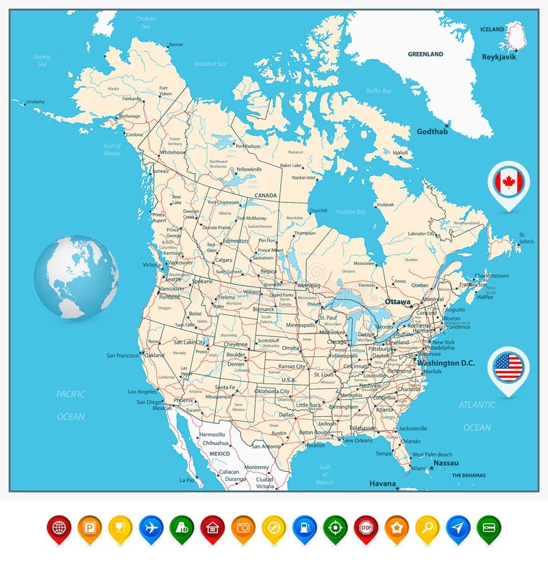
Free with trial USA and Canada large detailed political map with map pointers, states, provinces and capital cities in USA and Canada. Mapping vectors USA and Canada large detailed political map with map pointers. States, provinces and capital cities in USA and Canada
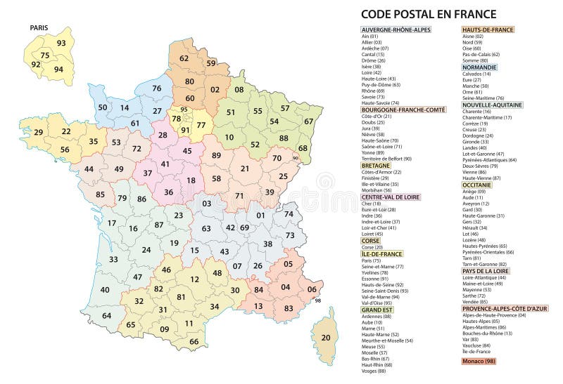
Free with trial France 2 digit postcodes postal codes vector map. Mapping vectors France 2 digit postcodes postal codes vector map.
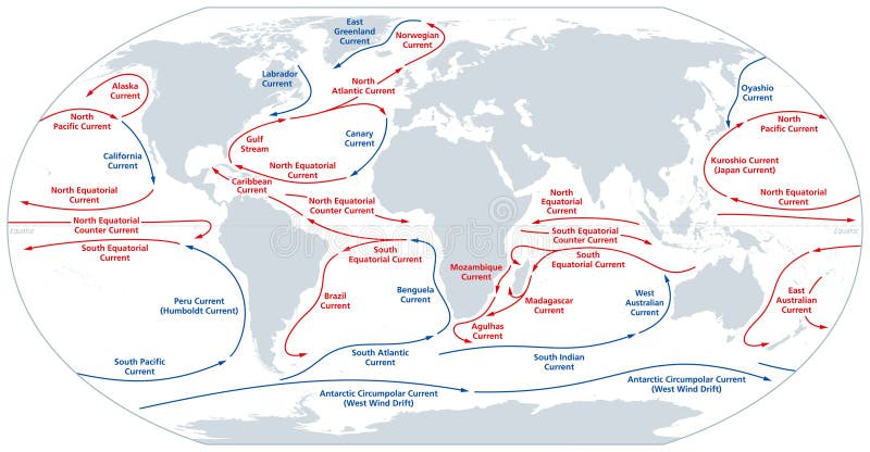
Free with trial World map of major ocean currents. Continuous,directed movement of seawater generated by forces acting upon the water,like wind,temperature,etc. Warm currents shown in red,cold currents in blue. Mapping vectors World map of major ocean currents, warm currents in red, cold currents in blue. World map of major ocean currents. Continuous,directed movement of seawater. World map of major ocean currents. Continuous,directed movement of seawater generated by forces acting upon the water,like wind,temperature,etc. Warm currents shown in red,cold currents in blue.
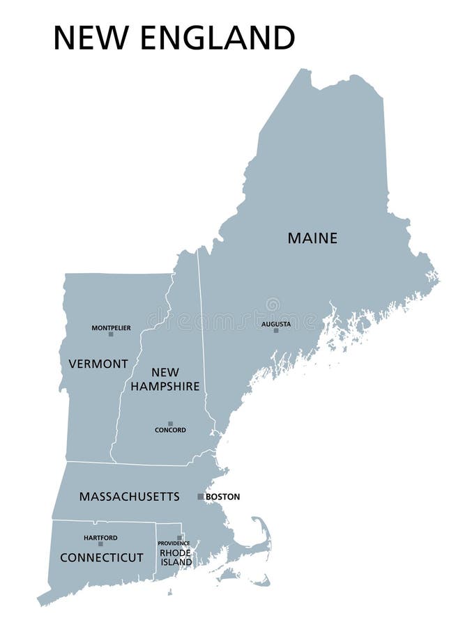
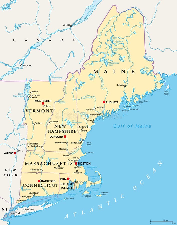
Free with trial New England region of the United States of America, gray political map. The six states Maine, Vermont, New Hampshire, Massachusetts, Rhode Island and Connecticut with capitals. Illustration. Vector. Mapping vectors New England region of the United States of America, gray political map. The six states Maine, Vermont, New Hampshire, Massachusetts, Rhode Island and
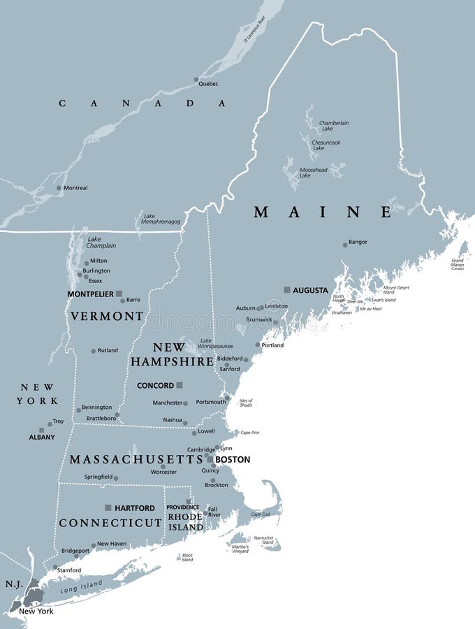
Free with trial New England region of the United States of America, gray political map. Maine, Vermont, New Hampshire, Massachusetts, Rhode Island and Connecticut with capitals and borders. Illustration. Vector. Mapping vectors New England region of the United States, gray political map. New England region of the United States of America, gray political map. Maine, Vermont, New. New England region of the United States of America, gray political map. Maine, Vermont, New Hampshire, Massachusetts, Rhode Island and Connecticut with capitals and borders. Illustration. Vector.
Free with trial Flat banner set with hand holding phone with city background and. Tourist way with points. Map application ads. Eps10. Mapping vectors Flat banner set with hand holding phone with city background and. Tourist way with points. Map application ads. Eps10
Free with trial Vector High detailed accurate, exact United States of America, american road, motorway map with labeling. Geographic pastel administrative. Editable cartography illustration. Mapping vectors Vector High detailed accurate, exact United States of America. American road, motorway map with labeling. Geographic pastel administrative. Editable. Vector High detailed accurate, exact United States of America, american road, motorway map with labeling. Geographic pastel administrative. Editable cartography illustration
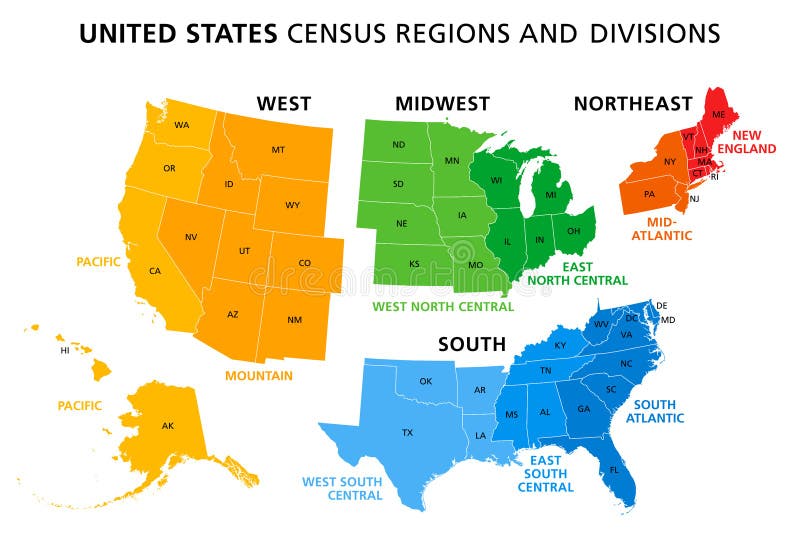
Free with trial Map of United States split into Census regions and divisions. Region definition, widely used for data collection and analysis. Most commonly used classification system. English. Illustration. Vector. Mapping vectors Map of United States split into Census regions and divisions. Region definition, widely used for data collection and analysis. Most commonly used
Free with trial Marker hand drawn chart. Mind map doodle elements. Elements drawn marker for structure and management. Vector Illustration of figures painted marker. Mapping vectors Marker hand drawn chart. Mind map doodle elements. Elements drawn marker for structure and management. Illustration of. Marker hand drawn chart. Mind map doodle. Marker hand drawn chart. Mind map doodle elements. Elements drawn marker for structure and management. Vector Illustration of figures painted marker
Free with trial New England region of the United States of America, political map. Maine, Vermont, New Hampshire, Massachusetts, Rhode Island and Connecticut with their Capitals and borders. Illustration. Vector. Mapping vectors New England region of the United States of America, political map. Maine, Vermont, New Hampshire, Massachusetts, Rhode Island and Connecticut with their
Free with trial Genome data. Genetics sequence barcode visualisation, dna test and genetic medical sequencing map. Genomics genealogy sequencing data, chromosome architecture vector concept illustration. Mapping vectors Genome data. Genetics sequence barcode visualisation, dna test and genetic medical sequencing map vector concept. Genome data. Genetics sequence barcode. Genome data. Genetics sequence barcode visualisation, dna test and genetic medical sequencing map. Genomics genealogy sequencing data, chromosome architecture vector concept illustration
Free with trial Road Map Destination Route. Road Map Destination Travel Route. Mapping vectors Road Map Destination Route. Road Map Destination Travel Route
Free with trial Seamless Abstract topographical map. Seamless pattern can be used for wallpaper, pattern fills, web page background,surface textures. Gorgeous seamless background. Mapping vectors Seamless Abstract topographical map. Seamless pattern can be used for wallpaper, pattern fills, web page background. Surface textures. Gorgeous seamless
Free with trial Genomic analysis visualization. Dna genomes sequencing, deoxyribonucleic acid genetic map and genome sequence analyse. Bioinformatics forensics data or dna radiographic testing vector concept. Mapping vectors Genomic analysis visualization. Dna genomes sequencing, deoxyribonucleic acid genetic map and genome sequence analyse. Bioinformatics forensics data or dna
Free with trial Detailed Relief map of USA. Retro color. No text. Mapping vectors Detailed Relief map of USA. Retro color. No text
Free with trial Abstract USA Map - vector illustration - geometric structure in blue color for presentation, booklet, website and other design projects. United States of America - abstract vector map. Mapping vectors Abstract USA Map - vector illustration - geometric structure in blue color. For presentation, booklet, website and other design projects. United States of. Abstract USA Map - vector illustration - geometric structure in blue color for presentation, booklet, website and other design projects. United States of America - abstract vector map.
Free with trial Pacific Ring of Fire,map with oceanic trenches. Also known as Rim of Fire,and as Circum-Pacific Belt. Region around the rim of the Pacific Ocean,where many volcanic eruptions and earthquakes occur. Mapping vectors Pacific Ring of Fire, also known as Rim of Fire, map with ocean trenches. Pacific Ring of Fire,map with oceanic trenches. Also known as Rim of Fire,and as Circum. Pacific Ring of Fire,map with oceanic trenches. Also known as Rim of Fire,and as Circum-Pacific Belt. Region around the rim of the Pacific Ocean,where many volcanic eruptions and earthquakes occur.
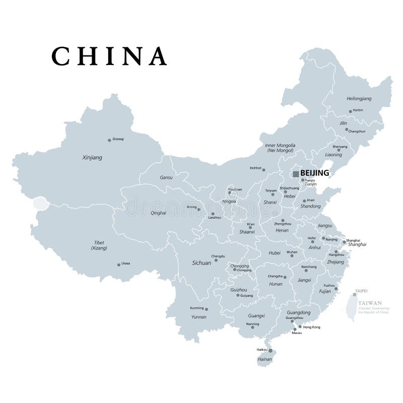
Free with trial China, gray political map, with administrative divisions. PRC, People`s Republic of China with capital Beijing, provinces with capitals and borders. English labeling. Illustration over white. Vector. Mapping vectors China, gray political map, provinces, administrative divisions. China, gray political map, with administrative divisions. PRC, People`s Republic of China with. China, gray political map, with administrative divisions. PRC, People`s Republic of China with capital Beijing, provinces with capitals and borders. English labeling. Illustration over white. Vector.
Free with trial Cape cod map. Detailed road map of the island of Cape Cod. Mapping vectors Cape cod map. Detailed road map of the island of Cape Cod
Free with trial 2-digit postcode areas Switzerland. Map. Mapping vectors 2-digit postcode areas Switzerland. Map
Free with trial Poland Map and Poland location on the Europe map isolated on transparent background. Highly detailed vector illustration of map. Mapping vectors Poland Map and Poland location on the Europe map isolated on transparent background. Highly detailed vector illustration of map
Free with trial Panama. Vector color map of Panama country. Mapping vectors Panama. Vector color map of Panama country
Free with trial Political blank map of Europe in white background. Vector illustration. Mapping vectors Political blank map of Europe in white background. Vector illustration
Free with trial Connecticut. Vector color map of Connecticut state. Usa. Mapping vectors Connecticut. Vector color map of Connecticut state. Usa
Free with trial Middle east map. Very detailed map of the Middle East. Mapping vectors Middle east map. Very detailed map of the Middle East
Free with trial High detailed Israel physical map. Vector illustration. Mapping vectors High detailed Israel physical map. Vector illustration
Free with trial City Map Main Roads Intersection. Illustration. Mapping vectors City Map Main Roads Intersection. Illustration
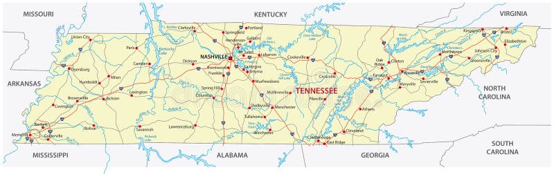
Free with trial The tennessee road map. The tennessee road vector map. Mapping vectors The tennessee road map. The tennessee road vector map
Free with trial Woman hand holding the smartphone with logo app Google Maps in vector format. Mapping vectors Woman hand holding the smartphone with logo app Google Maps, vector editorial illustration. Woman hand holding the smartphone with logo app Google Maps in. Woman hand holding the smartphone with logo app Google Maps in vector format
Free with trial High detailed Hungary physical map with labeling. Vector illustration. Mapping vectors High detailed Hungary physical map with labeling. Vector illustration
Free with trial World travel map. Pins on global earth maps, worldwide business communication. Earth map or globe location world travel mapping isolated concept illustration. Mapping vectors World travel map. Pins on global earth maps, worldwide business communication isolated concept illustration. World travel map. Pins on global earth maps. World travel map. Pins on global earth maps, worldwide business communication. Earth map or globe location world travel mapping isolated concept illustration
Free with trial Top view garden elements. Aerial houses, green trees and bushes, pool and benches for landscape architectural plan. Vector items isolated set. Mapping vectors Top view garden elements. Aerial houses, green trees and bushes, pool and benches for landscape architectural plan. Vector items isolated set
Free with trial Terrain map. Topographic contouring line cartography texture. Topographical relief map. Geographic vector background. Flat. Mapping vectors Terrain map. Topographic contouring line cartography texture. Topographical relief map. Geographic vector background. Flat
Free with trial High detailed North America physical map with labeling. Vector illustration. Mapping vectors High detailed North America physical map with labeling. Vector illustration
Free with trial Map of a top. View from the rooftops, city streets, trees and highways. Mapping vectors Map of a top. View from the rooftops, city streets, trees and highways
Free with trial High detailed France physical map with labeling. Vector illustration. Mapping vectors High detailed France physical map with labeling. Vector illustration
Free with trial High detailed Romania physical map with labeling. Vector illustration. Mapping vectors High detailed Romania physical map with labeling. Vector illustration
Free with trial Long island map. Map of long Iceland in new york state. Mapping vectors Long island map. Map of long Iceland in new york state
Free with trial Big data and database. Big data technology managing datas from public to database - concept idease with vintage color. Mapping vectors Big data and database. Big data technology managing datas from public to database - concept idease with vintage color
Free with trial Graphic of the North American great lakes and their neighboring states. Mapping vectors Graphic of the North American great lakes and their neighboring states.
Free with trial Map of the Sahara desert and Sahel zone. Vector map of the Sahara desert and Sahel zone. Mapping vectors Map of the Sahara desert and Sahel zone. Vector map of the Sahara desert and Sahel zone
Free with trial High detailed United States of America physical map with labeling. Vector illustration. Mapping vectors High detailed United States of America physical map with labeling. Vector illustration
Free with trial Isometric factory. Consists of a hangar, boiler, boiler room and storage. Mapping vectors Isometric factory. Consists of a hangar, boiler, boiler room and storage
Free with trial High detailed South America physical map with rivers and surface elements. Mapping vectors High detailed South America physical map with labeling. High detailed South America physical map with rivers and surface elements. High detailed South America physical map with rivers and surface elements.
Free with trial Stock vector AFRICA map icon Vector illustration 1. Mapping vectors Stock vector AFRICA map icon Vector illustration 1
Free with trial Medical Healthcare Icons w People Charting Disease or Scientific Discovery Web Header Banner. Mapping vectors Medical Healthcare Icons with People Charting Disease / Scientific Discovery Web Header Banner. Medical Healthcare Icons w People Charting Disease or Scientific. Medical Healthcare Icons w People Charting Disease or Scientific Discovery Web Header Banner
Free with trial Road map of the US American State of florida. Mapping vectors Road map of the US American State of florida.
Free with trial Road administrative map of the Romanian capital Bucharest. Road administrative and political map of the Romanian capital Bucharest. Mapping vectors Road administrative map of the Romanian capital Bucharest. Road administrative and political map of the Romanian capital Bucharest
Free with trial Province manitoba vector road and travel map. Mapping vectors Province manitoba vector road and travel map.
Free with trial Roads, political and administrative map of the Western United States of America with National Parks. Mapping vectors Roads, political and administrative map of the Western United States of America with National Parks.
Free with trial Vector map of canada island Vancouver island. Mapping vectors Vector map of canada island Vancouver island.
Free with trial High detailed Ukraine physical map with labeling. Vector illustration. Mapping vectors High detailed Ukraine physical map with labeling. Vector illustration
 Sign in